University of Minnesota
http://www.umn.edu/
612-625-5000
http://www.umn.edu/
612-625-5000
Minnesota Biodiversity Atlas
Bell Museum
Dataset: All Collections
Taxa: Plagiothecium denticulatum (Plagiothecium ruthei, Plagiothecium denticulatum var. bullulae, Plagiothecium denticulatum var. donii, Plagiothecium denticulatum var. majus, Plagiothecium denticulatum var. obtusifolium, Plagiothecium denticulatum var. undulatum, Hypnum lamprostachys), Plagiothecium denticulatum f. propaguliferum, Plagiothecium denticulatum var. donnianum, Plagiothecium denticulatum var. donnii, Plagiothecium denticulatum var. obtusatum, Plagiothecium denticulatum var. densum
Search Criteria: Bell Museum bryophytes; Minnesota; excluding cultivated/captive occurrences
1
Page 1, records 1-43 of 43
Bell Museum bryophytes | |
 MIN:Bryophytes |  Plagiothecium denticulatum (Hedw.) Schimp. 610565[1151972]Olson, W.A. 6941960-08-16 United States, Minnesota, Cook, Island no6 of Susie Islands, 47.973776 -89.578978 |
MIN:Bryophytes | 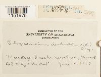 Plagiothecium denticulatum (Hedw.) Schimp. 383033[1151975]Van Wert, Mary C. s.n.1925-06-15 United States, Minnesota, Murdey Creek, near Anoka, 274m |
MIN:Bryophytes | 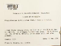 Plagiothecium denticulatum (Hedw.) Schimp. 853310[1151991]Bowers, Frank D. 22862a1994-09-17 United States, Minnesota, Cook, Lutsen State Natural Area, ca 3 km NE of Jct 36 & 61 (Hwy 61) NW 1/4. NE of Eagle Mountain ski area, T 60 N, R 3 W, sec. 21 |
MIN:Bryophytes | 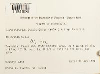 Plagiothecium denticulatum (Hedw.) Schimp. 853499[1151996]F. Bowers 226341994-09-01 United States, Minnesota, Lake, Kawishiwi Pines RNA State Natural Area, ca 9 mi SE of Ely, T 62 N, R11 W, sec. 16, W1/2 of SW 1/4; 47.833333 -91.75; 47.833333 -91.75; 47.833333 -91.75, 47.833333 -91.75 |
MIN:Bryophytes | 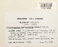 Plagiothecium denticulatum (Hedw.) Schimp. 748855[1151956]Janssens, Jan A. 111951982-08-22 United States, Minnesota, Beltrami, Waskish Area: 22.3 km north of Waskish, 0.5 km south of county line, along west side of Hwy 72 (NW SE NE S1 T156N R31W), 48.366667 -94.55, 363m |
MIN:Bryophytes | 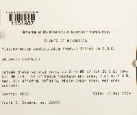 Plagiothecium denticulatum (Hedw.) Schimp. 852486[1151987]Bowers, Frank D. 229201994-10-17 United States, Minnesota, Cook, Lutsen State Natural Area, ca 3 km NE of Jct 36 & 61 (Hwy 61) NW 1/4. NE of Eagle Mountain ski area, T 60 N, R 3 W, sec. 21, 47.75 -90.733333 |
MIN:Bryophytes | 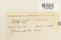 Plagiothecium denticulatum (Hedw.) Schimp. 400893[1151980]Newcomb, Eloise s.n.1941-08-13 United States, Minnesota, Clearwater, south of ice house, Itasca Park |
MIN:Bryophytes | 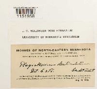 Plagiothecium denticulatum (Hedw.) Schimp. 648289[1151958]Holzinger, J.M. s.n.1902-08-15 United States, Minnesota, Cook, On Hat Point, a peninsula projecting southward from Mt. Josephine, into Lake Superior, near Grand Portage. |
MIN:Bryophytes | 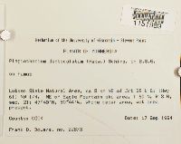 Plagiothecium denticulatum (Hedw.) Schimp. 852472[1151989]Bowers, Frank D. 228731994-09-17 United States, Minnesota, Cook, Lutsen State Natural Area, ca 3 km NE of Jct 36 & 61 (Hwy 61) NW 1/4. NE of Eagle Mountain ski area, T 60 N, R 3 W, sec. 21, 47.75 -90.733333 |
MIN:Bryophytes |  Plagiothecium denticulatum (Hedw.) Schimp. 648351[1151964]Holzinger, J. M. s.n.1903-07-19 United States, Minnesota, Cook, Along the Little Devil's Track, north of Grand Marais |
MIN:Bryophytes | 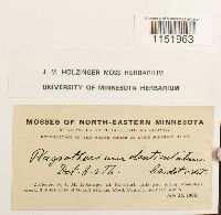 Plagiothecium denticulatum (Hedw.) Schimp. 648294[1151963]J.M. Holzinger s.n.1902-07-28 United States, Minnesota, Cook, At Rosebush falls and along Rosebush creek, 3 mi W of Grand Marais |
MIN:Bryophytes | 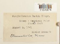 Plagiothecium denticulatum (Hedw.) Schimp. 400891[1151974]Newcomb, Eloise s.n.1941-08-08 United States, Minnesota, Clearwater, Garrison Point, Itasca Park |
MIN:Bryophytes |  Plagiothecium denticulatum (Hedw.) Schimp. 41493[1151973]J.M. Holzinger s.n.1897-06-08 United States, Minnesota, Saint Louis, On Fall Lake, near the foot of Kawasatchong Falls, 7 mi N of Ely, Minn. |
MIN:Bryophytes |  Plagiothecium denticulatum (Hedw.) Schimp. 648293[1151962]Holzinger, J.M. s.n.1902-07-16 United States, Minnesota, Cook, In the vicinity of Grand Marais |
MIN:Bryophytes |  Plagiothecium denticulatum (Hedw.) Schimp. 648347[1151965]J.M. Holzinger s.n.1902-07-16 United States, Minnesota, Cook, in the vicinity of Grand Marais; 48 |
MIN:Bryophytes |  Plagiothecium denticulatum (Hedw.) Schimp. 648290[1151959]Holzinger, J. M. 3711901-07-16 United States, Minnesota, Cook, In the vicinity of Grand Marais, Cook County, near lat. 48d N |
MIN:Bryophytes | 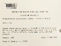 Plagiothecium denticulatum (Hedw.) Schimp. 852484[1151988]Bowers, Frank D. s.n.1994-09-17 United States, Minnesota, Cook, Lutsen State Natural Area, ca 3 km NE of Jct 36 & 61 (Hwy 61) NW 1/4. NE of Eagle Mountain ski area, T 60 N, R 3 W, sec. 21, 47.75 -90.733333 |
MIN:Bryophytes | 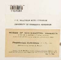 Plagiothecium denticulatum (Hedw.) Schimp. 648286[1151981]Holzinger, J.M. s.n.1902-08-15 United States, Minnesota, on Hat Point, a peninsula projecting southward from Mt. Josephine, into Lake Superior, near Grand Portage, lat. 48-N |
MIN:Bryophytes | 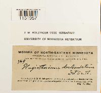 Plagiothecium denticulatum (Hedw.) Schimp. 648288[1151957]J.M. Holzinger 3491902-08-15 United States, Minnesota, Cook, On Hat Point, a peninsula projecting southward from Mt. Josephine, into Lake Superior, near Grand Portage |
MIN:Bryophytes | 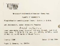 Plagiothecium denticulatum (Hedw.) Schimp. 852781[1151986]Bowers, Frank D. 23421a1994-09-08 United States, Minnesota, Cook, Loon Lake white pine, Superior National Forest, just N of Loon Lake. T 65 N, R 3 2, sec. 25. North of Hwy 12, ca 45 km NW of Grand Marais, 48.05 -90.733333 |
MIN:Bryophytes | 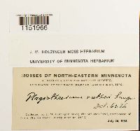 Plagiothecium denticulatum (Hedw.) Schimp. 648348[1151966]Holzinger, J.M. s.n.1902-07-00 United States, Minnesota, Cook, along the old Iron Trail, northwest of Grand Marais, near lat. 48-N |
MIN:Bryophytes | 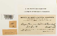 Plagiothecium denticulatum (Hedw.) Schimp. 648292[1151961]J.M. Holzinger s.n.1902-07-16 United States, Minnesota, Cook, in the vicinity of Grand Marais, near lat. 48° N. |
MIN:Bryophytes | 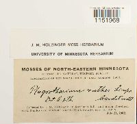 Plagiothecium denticulatum (Hedw.) Schimp. 648350[1151968]J.M. Holzinger s.n.1902-07-28 United States, Minnesota, Cook, At Rosebush falls and along Rosebush creek, 3 mi W of Grand Marais |
MIN:Bryophytes | 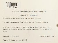 Plagiothecium denticulatum (Hedw.) Schimp. 852053[1151954]Bowers, Frank D. 24117b1994-08-31 United States, Minnesota, Saint louis, T 63 N, R 13 W, sec. 2 + sec. 11. White pine area north of Burntside Lake, ca 9 km NW of Ely;, 47.966667 -91.966667 |
MIN:Bryophytes | 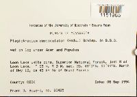 Plagiothecium denticulatum (Hedw.) Schimp. 852785[1151985]F. Bowers 234251994-09-08 United States, Minnesota, Cook, Loon Lake, Superior National Forest, ca. 45 km NW of Grand Marais. Just N of Loon Lake, N of Hwy 12.; 48.05 -90.733333; 48.05 -90.733333; 48.05 -90.733333, 48.05 -90.733333 |
MIN:Bryophytes | 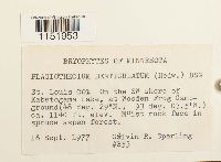 Plagiothecium denticulatum (Hedw.) Schimp. 850781[1151953]Sperling, Calvin R. B531977-09-16 United States, Minnesota, Saint louis, On the SW shore of Kabetogama Lake, at Wooden Frog Campground., 48.483333 -95.05, 347m |
MIN:Bryophytes | 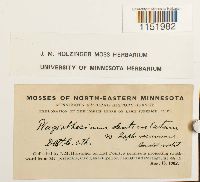 Plagiothecium denticulatum (Hedw.) Schimp. 648287[1151982]Holzinger, J.M. s.n.1902-08-15 United States, Minnesota, on Hat Point, a peninsula projecting southward from Mt. Josephine, into Lake Superior, near Grand Portage; 48 |
MIN:Bryophytes | 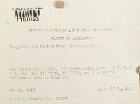 Plagiothecium denticulatum (Hedw.) Schimp. 852111[1151993]Bowers, Frank D. 22984b1994-09-17 United States, Minnesota, Lake, Heartbreak Creek cRNA, old growth white cedar; ca. 3 km NNE cf Schroeder, west of Road 343; 47.583333 -90.916667, 47.583333 -90.916667 |
MIN:Bryophytes | 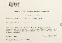 Plagiothecium denticulatum (Hedw.) Schimp. 852073[1151952]F. Bowers 2402Bc1994-09-02 United States, Minnesota, Lake, Tettegouche State Park. SE 1/4 of Sec. 7. 7 acre upland "island" along Northshore of Tettegouche; 47.316667 -91.266667; 47.316667 -91.266667; 47.316667 -91.266667, 47.316667 -91.266667 |
MIN:Bryophytes | 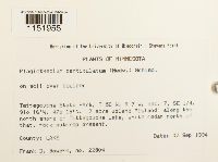 Plagiothecium denticulatum (Hedw.) Schimp. 852056[1151955]F. Bowers 228041994-09-02 United States, Minnesota, Lake, Tettegouche State Park. SE 1/4 of Sec. 7. 7 acre upland "island" along Northshore of Tettegouche; 47.316667 -91.266667; 47.316667 -91.266667; 47.316667 -91.266667, 47.316667 -91.266667 |
MIN:Bryophytes |  Plagiothecium denticulatum (Hedw.) Schimp. 648291[1151960]J.M. Holzinger 151902-07-16 United States, Minnesota, Cook, In the vicinity of Grand Marais |
MIN:Bryophytes |  Plagiothecium denticulatum (Hedw.) Schimp. 648349[1151967]Holzinger, J.M. s.n.1902-08-15 United States, Minnesota, on Hat Point, a peninsula projecting southward from Mt. Josephine, into Lake Superior, near Grand Portage, lat. 48-N |
MIN:Bryophytes | 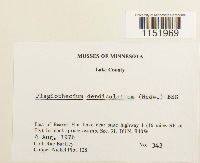 Plagiothecium denticulatum (Hedw.) Schimp. 753937[1151969]Barkley, Rae 3431976-08-04 United States, Minnesota, Lake, east of Beaver Hut Lake near state highway 1 (16 miles SE of Ely). Sec. 31, T61N, R10W. Copper-Nickel Plot T28 |
MIN:Bryophytes | 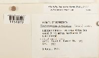 Plagiothecium denticulatum (Hedw.) Schimp. 677669[1151970]Bowers, Frank D. 9511975-08-08 United States, Minnesota, Hubbard, At Lake Alice Bog about 3 1/2 miles northwest of Lake George. |
MIN:Bryophytes | 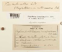 Plagiothecium denticulatum (Hedw.) Schimp. 41501[1151971]Nelson 151901-05-03 United States, Minnesota, Fish hatchery |
MIN:Bryophytes | 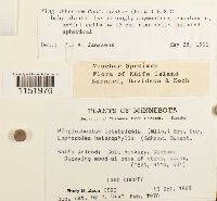 Plagiothecium denticulatum (Hedw.) Schimp. 619794[1151976]Koch, Rudy G. s.n.1969-10-18 United States, Minnesota, Lake, Knife Island; Gull Rookery, Diabase. (T52N, R11W, S31) |
MIN:Bryophytes |  Plagiothecium denticulatum (Hedw.) Schimp. 610564[1151978]Olson, W.A. 6071960-08-02 United States, Minnesota, Koochiching, T69N, R23W, SE1/4 NE1/4 Sec 6, near Ericsburg |
MIN:Bryophytes |  Plagiothecium denticulatum (Hedw.) Schimp. 610563[1151979]Olson, W. A. 5571960-07-22 United States, Minnesota, Saint louis, Distal end of Minnesota Point, Duluth |
MIN:Bryophytes |  Plagiothecium denticulatum (Hedw.) Schimp. 864789[1151983]Wheeler, Gerald A. 168871997-07-26 United States, Minnesota, Stearns, Ca. 5 mi. N of St. Joseph, W of Rte. 4; NW1/4 SW1/4 SE1/4 Sec. 16 T135N R29W (St. Wendel 16). |
MIN:Bryophytes |  Plagiothecium denticulatum (Hedw.) Schimp. 865202[1151984]Smith, Michael R. 7081998-06-27 United States, Minnesota, Voyageurs National Park. UTM 537250 E 5360863 N Zone 15 NAD 83 |
MIN:Bryophytes |  Plagiothecium denticulatum (Hedw.) Schimp. 853256[1151992]Bowers, Frank D. 242341995-09-23 United States, Minnesota, Lake, Crosby-Manitow State Park, T 58 N, R 6 W, sec. 28, SW 1/4 & sec. 32, SE 1/4, ca 12 km North of Little Marais, East of Hwy 7. |
MIN:Bryophytes | 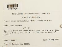 Plagiothecium denticulatum (Hedw.) Schimp. 853516[1151994]Bowers, Frank D. 22660a1994-09-01 United States, Minnesota, Lake, Kawishiwi Pines RNA State Natural Area, ca 9 mi SE of Ely. T 62 N, R 11 W, sec. 16, W 1/2 of SW 1/4, 47.833333 -91.75 |
MIN:Bryophytes | 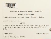 Plagiothecium denticulatum (Hedw.) Schimp. 853503[1151995]Bowers, Frank D. 22647a1994-09-01 United States, Minnesota, Lake, Kawishiwi Pines RNA State Natural Area, ca 9 mi Se of Ely. T 62 N, R 11 W, sec. 16, W 1/2 of SW 1/4, 47.833333 -91.75 |
1
Page 1, records 1-43 of 43
Google Map
Google Maps is a web mapping service provided by Google that features a map that users can pan (by dragging the mouse) and zoom (by using the mouse wheel). Collection points are displayed as colored markers that when clicked on, displays the full information for that collection. When multiple species are queried (separated by semi-colons), different colored markers denote each individual species.