University of Minnesota
http://www.umn.edu/
612-625-5000
http://www.umn.edu/
612-625-5000
Minnesota Biodiversity Atlas
Bell Museum
Dataset: All Collections
Taxa: Anomodon attenuatus (Anomodon flagelliformis, Anomodon wrightii, Hypnum fulvum, Hypnum stoloniferum)
Search Criteria: Bell Museum bryophytes; Minnesota; excluding cultivated/captive occurrences
1
Page 1, records 1-67 of 67
Bell Museum bryophytes | |
 MIN:Bryophytes | 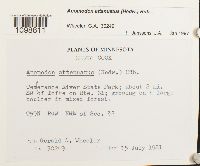 Anomodon attenuatus (Hedw.) Huebener 857374[1098811]Gerald A. Wheeler 302491981-07-15 United States, Minnesota, Cook, Temeranee River State Park; about 2 rai. SW of Tofte on Rte. 61 |
MIN:Bryophytes | 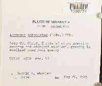 Anomodon attenuatus (Hedw.) Huebener 856820[1098774]Gerald A. Wheeler 311411985-05-27 United States, Minnesota, Sherburne, Near St. Cloud, E side of city; granitic outcrop and adjacent woodland |
MIN:Bryophytes | 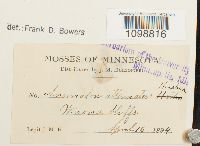 Anomodon attenuatus (Hedw.) Huebener 27926[1098816]J.M.H. s.n.1894-04-16 United States, Minnesota, Winona bluffs |
MIN:Bryophytes | 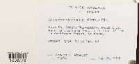 Anomodon attenuatus (Hedw.) Huebener 856866[1098773]Gerald A. Wheeler 310741985-05-26 United States, Minnesota, Stearns, Near St. John's University; about 2 mi. NW of St. Joseph |
MIN:Bryophytes | 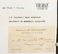 Anomodon attenuatus (Hedw.) Huebener 636745[1098818]J.M. Holzinger 371894-05-00 United States, Minnesota, Winona bluffs |
MIN:Bryophytes |  Anomodon attenuatus (Hedw.) Huebener 876372[1098799]Gerald A. Wheeler 201581999-07-31 United States, Minnesota, Carver, Ca. 0.5 mi. SSW of East Union on Rte. 40, W of road. Near edge of steep bluff overlooking Bevens Creek; NE 1/4 SW 1/4; San Francisco 3 |
MIN:Bryophytes |  Anomodon attenuatus (Hedw.) Huebener 876325[1098797]Gerald A. Wheeler 186141998-05-19 United States, Minnesota, Redwood, NW edge of North Redwood. N1/2 NW1/4 Section 30 |
MIN:Bryophytes |  Anomodon attenuatus (Hedw.) Huebener 857095[1098790]Gerald A. Wheeler 308521984-07-10 United States, Minnesota, Winona, John A. Latsch State Park; about 6.5 mi. NW of Minnesota City on Rte. 61. |
MIN:Bryophytes | 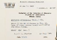 Anomodon attenuatus (Hedw.) Huebener 857116[1098756]Gerald A. Wheeler 308281984-07-10 United States, Minnesota, Winona, About 13 km SE of Winona on Rte. 61; overlooking Big Trout Creek. |
MIN:Bryophytes | 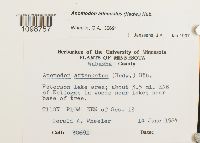 Anomodon attenuatus (Hedw.) Huebener 857320[1098757]Gerald A. Wheeler 306911984-06-14 United States, Minnesota, Wabasha, Peterson Lake area; about 3.5 mi. ENE of Kellogg; T110 N R10W NE1/4 of Sec. 13 |
MIN:Bryophytes | 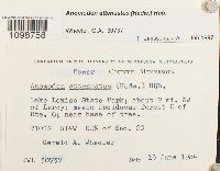 Anomodon attenuatus (Hedw.) Huebener 857140[1098758]Gerald A. Wheeler 307371984-06-15 United States, Minnesota, Mower, Lake Louise State Park; about 2 mi. NW of Leroy; E of Rte. 6; SE1/4 of Section 20 |
MIN:Bryophytes |  Anomodon attenuatus (Hedw.) Huebener 852672[1098759]Frank D. Bowers 235661995-09-09 United States, Minnesota, Cook, sec. 30 + sec. 31. Temperence River State Park, along river and falls, 1.2 km N of Schroeder on Hwy 61, 47.516667 -90.933333 |
MIN:Bryophytes |  Anomodon attenuatus (Hedw.) Huebener 852596[1098760]Frank D. Bowers 239491995-09-22 United States, Minnesota, Lake, Crosby-Manitou State Park ca. 12 km north of Little Marais and east of Hwy 7; mostly SW 1/4 Section 28 |
MIN:Bryophytes |  Anomodon attenuatus (Hedw.) Huebener 865062[1098761]Gerald A. Wheeler 160451997-06-09 United States, Minnesota, Brown, Ca. 2.3 mi. NW of Rte. 13, NW of New Ulm; N1/2 NW 1/4 SW 1/4 Sec. 3 T110N R31W (Milford 3) |
MIN:Bryophytes |  Anomodon attenuatus (Hedw.) Huebener 865039[1098762]Gerald A. Wheeler 161091997-06-11 United States, Minnesota, Blue Earth, Ca. 4 mi. W of Mankato on Rte. 169; Minneopa State Park; NW1/4 NW1/4 Section 21 (South Bend 21) |
MIN:Bryophytes |  Anomodon attenuatus (Hedw.) Huebener 865167[1098763]Gerald A. Wheeler 155661997-05-20 United States, Minnesota, Renville, Ca. 1.5 mi. NE of Morton. S of Rte. 2; Birch Coulee State Memorial Park; NW1/4 Nw 1/4 Section 28 (Birch Cooley 28) |
MIN:Bryophytes | 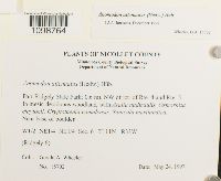 Anomodon attenuatus (Hedw.) Huebener 865137[1098764]Gerald A. Wheeler 157021997-05-24 United States, Minnesota, Nicollet, Fort Ridgely State Park; 0.6 mi. NW of jct. of Rte. 4 and Rte. 5.; W1/2 NE1/4 NE1/4 Section 6 (Ridgely 6) |
MIN:Bryophytes | 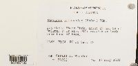 Anomodon attenuatus (Hedw.) Huebener 856725[1098765]Gerald A. Wheeler 302961981-07-17 United States, Minnesota, Carlton, Jay Cooke State Park; about 15 mi. SV of Duluth; F of Rte. 210; T48N R16W N1/2 of Sec. 10 |
MIN:Bryophytes |  Anomodon attenuatus (Hedw.) Huebener 856769[1098766]Gerald A. Wheeler 301051981-06-05 United States, Minnesota, Lake, Caribou Falls State Park; forest N of Rte, 61 along E bank of Caribou River; NE1/4 of Section 36 |
MIN:Bryophytes |  Anomodon attenuatus (Hedw.) Huebener 876223[1098767]Gerald A. Wheeler 189221998-06-05 United States, Minnesota, Carver, Ca. 2.5 mi. SE of East Union, E of Rte. 45. Minnesota River; N1/2 SW1/4 Section 7 |
MIN:Bryophytes |  Anomodon attenuatus (Hedw.) Huebener 876156[1098768]Gerald A. Wheeler 188801998-06-05 United States, Minnesota, Scott, Minnesota County Biological Survey Department of Natural Resources. Ca. 1.5 mi. N of Jordan on Rte. 9, E of road. Minnesota River. N1/2 SW1/4 SW1/4 Section 7. (Sand Creek 7) |
MIN:Bryophytes |  Anomodon attenuatus (Hedw.) Huebener 876194[1098769]Gerald A. Wheeler 191001997-06-13 United States, Minnesota, Le Sueur, Ca. 2 mi N of Ottawa; 0.7 mi. W of Rte. 36; Chamberlain Woods SNA. Along wooded bluff overlooking the Minnesota River valley, with Festuca obtusa, Carex cephalophora, C. eburnea C. tenera; W1/2 NW 1/4 Sec. 22 T111N R26W (Ottawa 22) |
MIN:Bryophytes |  Anomodon attenuatus (Hedw.) Huebener 853457[1098770]Dan Hatleli 481993-04-10 United States, Minnesota, Fillmore, 9 miles south of Rushford, MN, west of Hwy. 43 in Norway township |
MIN:Bryophytes |  Anomodon attenuatus (Hedw.) Huebener 852847[1098771]Frank D. Bowers 235611995-09-09 United States, Minnesota, Cook, sec. 30 + sec. 31. Temperence River State Park, along river and falls, 1.2 km N of Schroeder on Hwy 61, 47.516667 -90.933333 |
MIN:Bryophytes |  Anomodon attenuatus (Hedw.) Huebener 856838[1098772]Gerald A. Wheeler 311091985-05-26 United States, Minnesota, Stearns, About 1.5 mi. W of Rockville on unmarked county road; growing N of road; S1/2 of Section 8 |
MIN:Bryophytes |  Anomodon attenuatus (Hedw.) Huebener 856804[1098775]Gerald A. Wheeler 311601985-05-27 United States, Minnesota, Sherburne, Sand Dunes State Forest; about 4 mi. N of Zimmerman on Rte. 4; T34N R27W N1/2 of Sec. 15 |
MIN:Bryophytes |  Anomodon attenuatus (Hedw.) Huebener 857348[1098776]Gerald A. Wheeler 306571984-05-23 United States, Minnesota, Houston, About 3.5 mi. S of La Crescent; between Rte. 7 and the Root River; N1/2 of NW1/4 of Section 34 |
MIN:Bryophytes |  Anomodon attenuatus (Hedw.) Huebener 857338[1098777]Gerald A. Wheeler 306691984-05-23 United States, Minnesota, Houston, Beaver Creek Valley State Park; about 1.5 mi. N of Rte. 12; overlooking Beaver Creek. W1/2 of Sec. 8 |
MIN:Bryophytes |  Anomodon attenuatus (Hedw.) Huebener 865068[1098778]Gerald A. Wheeler 160031997-06-08 United States, Minnesota, Nicollet, Ca. 4 mi. SSW of Nicollet on Rte. 23; Swan Lake State WMA |
MIN:Bryophytes |  Anomodon attenuatus (Hedw.) Huebener 857262[1098779]Gerald A. Wheeler 304661982-06-04 United States, Minnesota, Pine, About 2 mi. S of Sturgeon Lake on Rte. 61; C. C. Andrews State Forest; S of jct. of Rte. 52 and the Kettle River; NW1/4 of Section 26 |
MIN:Bryophytes | 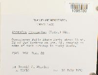 Anomodon attenuatus (Hedw.) Huebener 857021[1098780]Gerald A. Wheeler 312181985-07-18 United States, Minnesota, Lake, Gooseberry Falls State Park; about 15 mi. NW of Two Harbors on Rte. 61; T54N R9W Sec. 28. |
MIN:Bryophytes |  Anomodon attenuatus (Hedw.) Huebener 857240[1098781]Gerald A. Wheeler 304951982-06-04 United States, Minnesota, Pine, Banning State Park; 4.5 mi. NNW of Sandstone, and 1 mi. N of jet. of Rte. 23 and the Kettle River. W1/2 of Section 23 |
MIN:Bryophytes |  Anomodon attenuatus (Hedw.) Huebener 856916[1098782]Gerald A. Wheeler 306221982-07-17 United States, Minnesota, Carlton, About 1.5 mi. E of jct. Rte. 23 and Soo Railroad tracks |
MIN:Bryophytes |  Anomodon attenuatus (Hedw.) Huebener 857037[1098783]Wheeler, Gerald A. 338031996-06-09 United States, Minnesota, Rice, Nerstrand Woods State Park; about 2.5 mi. W of Nerstrand; woods N of Rte. 27; SW1/4 of Section 16 |
MIN:Bryophytes |  Anomodon attenuatus (Hedw.) Huebener 857047[1098784]Gerald A. Wheeler 337891996-06-09 United States, Minnesota, Steele, Rice Lake State Park; about 8 mi. E of Owatonna on Rte. 19; in mesic deciduous woods N of lake; T107N R19W W1/2 of Sec. 12 |
MIN:Bryophytes |  Anomodon attenuatus (Hedw.) Huebener 864763[1098785]Gerald A. Wheeler 169261997-07-27 United States, Minnesota, Stearns, Ca. 3 mi. W of Cold Spring on Rte. 23; 0.5 mi. S on Frostview Road, NE of road; NE1/4 SW1/4 SW1/4 SW1/4 of Section 20 (Wakefield 20) |
MIN:Bryophytes | 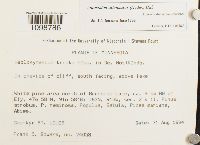 Anomodon attenuatus (Hedw.) Huebener 856524[1098786]Frank D. Bowers 240581994-08-31 United States, Minnesota, Saint Louis, White pine area north of Burnside Lake; ca. 9 km NW of Ely; T63N, R13W, sec. 2 & 11; Pinus strobus, P. resinosa, Populus, Betula, Picea mariana, Abies, 47.966667 -91.966667 |
MIN:Bryophytes |  Anomodon attenuatus (Hedw.) Huebener 876442[1098787]Gerald A. Wheeler 198411999-06-04 United States, Minnesota, Jackson, Minnesota County Biological Survey Department of Natural Resources. Ca. 6.5 mi. NE of Lakefield. Kilen Woods State Park. N1/2 SE1/4 Section 17 (Belmont 17) |
MIN:Bryophytes |  Anomodon attenuatus (Hedw.) Huebener 876369[1098788]Gerald A. Wheeler 191891998-06-15 United States, Minnesota, Scott, Ca. 4.5 mi. NNW of Jordan; 1.2 mi. W of Rte. 169. Louisville Swamp; Carver Rapids Wayside. On and around a large, flat Jordan Sandstone outcrop, with Selaginella rupestris, geranium carolinianus, and several rarities; SE 1/4 NE 1/4 NW 1/4 Sec. 32 T115N R23W (Louisville 32) |
MIN:Bryophytes |  Anomodon attenuatus (Hedw.) Huebener 857074[1098789]Gerald A. Wheeler 310181984-08-14 United States, Minnesota, Wabasha, Near Minneiska; about 10 mi. SE of Kellogg on Rte, 61; near Rte. 61; Section 33 |
MIN:Bryophytes |  Anomodon attenuatus (Hedw.) Huebener 636748[1098791]J.M. Holzinger s.n.1901-06-22 United States, Minnesota, Big Stone, The Upper Minnesota river, near Ortonville |
MIN:Bryophytes |  Anomodon attenuatus (Hedw.) Huebener 27923[1098792]J.M. Holzinger s.n.1901-07-10 United States, Minnesota, Yellow Medicine, near Granite Falls |
MIN:Bryophytes |  Anomodon attenuatus (Hedw.) Huebener 27921[1098793]J.M. Holzinger s.n.1901-06-22 United States, Minnesota, Big Stone, Near Ortonville, above lat. 45° N |
MIN:Bryophytes |  Anomodon attenuatus (Hedw.) Huebener 865084[1098794]Gerald A. Wheeler 158851997-06-05 United States, Minnesota, Renville, Ca. 9 mi. SSW of Renville on Rte. 6; W of road; County Park No. 2; E1/2 SW1/4 Section 19 (Flora 19) |
MIN:Bryophytes |  Anomodon attenuatus (Hedw.) Huebener 853206[1098795]Frank D. Bowers 235931995-09-09 United States, Minnesota, Cook, Temperence River State Park; along river and falls; 1.2 km N of Schroeder on Hwy 61; T59 N, R4 W sec. 30 + sec. 31, 47.516667 -90.933333 |
MIN:Bryophytes |  Anomodon attenuatus (Hedw.) Huebener 865124[1098796]Gerald A. Wheeler 157521997-05-24 United States, Minnesota, Nicollet, Near Fort Ridgely State Park. just E of the jet. of Rte. 4 and Rte. 5. SW1/4 NE1/4 SW1/4 Section 5 (Ridgely 5) |
MIN:Bryophytes |  Anomodon attenuatus (Hedw.) Huebener 876387[1098798]Gerald A. Wheeler 202261999-08-02 United States, Minnesota, Sibley, Ca. 2 mi. SW of Henderson; Rush River State Wayside Park. On moderate, wooded slope dominated by Tilia americana; E 1/2 SE 1/4 Sec. 15 T12N R26W (Henderson 15) |
MIN:Bryophytes |  Anomodon attenuatus (Hedw.) Huebener 852638[1098800]Frank D. Bowers 235481995-09-09 United States, Minnesota, Cook, sec. 30 + sec. 31. Temperence River State Park, 1.2 km N of Schroeder on Hwy 61., 47.516667 -90.933333 |
MIN:Bryophytes |  Anomodon attenuatus (Hedw.) Huebener 865107[1098801]Gerald A. Wheeler 158231997-05-26 United States, Minnesota, Renville, Ca. 15 mi. S of Danube on Rte. 1. W of road; NW1/4 NE1/4 SW1/4; Beaver Falls 20; T.113N, R.35W, Sec. 20 |
MIN:Bryophytes |  Anomodon attenuatus (Hedw.) Huebener 812938[1098802]Jan A. Janssens 87261982-06-11 United States, Minnesota, Washington, STILLWATER AREA: Fairy Falls Canyon, 45.08167 -92.80861, 230m |
MIN:Bryophytes |  Anomodon attenuatus (Hedw.) Huebener 865003[1098803]Gerald A. Wheeler 174431985-07-18 United States, Minnesota, Lake, Gooseberry Falls State Park; about 15 mi. NE of Two Harbors on Rte. 61; growing on edge of rock outcrop in rocky woods; T54N R9W Sec. 28 |
MIN:Bryophytes |  Anomodon attenuatus (Hedw.) Huebener 865011[1098804]Gerald A. Wheeler 173541997-08-28 United States, Minnesota, Nicollet, Ca. 2.5 mi. NW of Courtland on Rte. 14; Red Rock area; E1/2 SE1/4 SW1/4 Section 34 (Courtland 34) |
MIN:Bryophytes | 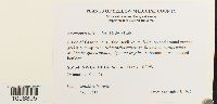 Anomodon attenuatus (Hedw.) Huebener 864922[1098805]Gerald A. Wheeler 176131997-09-03 United States, Minnesota, Yellow Medicine, S side of Granite Falls, Blue Devil Valley SNA. SW1/4 NW1/4 NE1/4 Sec. 4 T115N R39W (Minnesota Falls 4) |
MIN:Bryophytes | 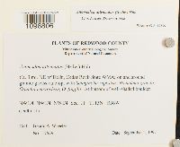 Anomodon attenuatus (Hedw.) Huebener 864926[1098806]Gerald A. Wheeler 175791997-09-02 United States, Minnesota, Redwood, Ca. 3 mi. NE of Delhi, Cedar Rock State WMA; NW1/4 NW1/4 NW1/4 Section 11 (Delhi 11) |
MIN:Bryophytes | 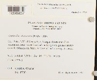 Anomodon attenuatus (Hedw.) Huebener 864938[1098807]Gerald A. Wheeler 177431997-09-06 United States, Minnesota, Brown, Ca. 15 mi. NW of Sleepy Eye, Morgan Sportsman Club Recreation Area; on and around shaded granite gneiss outcrop near the Minnesota River. N 1/2 NW 1/4 NW 1/4 Sec. 19 T112N R33W (Eden 19 'N') |
MIN:Bryophytes | 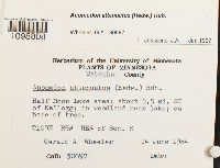 Anomodon attenuatus (Hedw.) Huebener 857162[1098808]Gerald A. Wheeler 306971984-06-14 United States, Minnesota, Wabasha, Half Moon Lake area; about 5.5 mi. SE of Kellogg; NE1/4 of Section 8 |
MIN:Bryophytes | 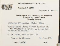 Anomodon attenuatus (Hedw.) Huebener 857147[1098809]Gerald A. Wheeler 307241984-06-14 United States, Minnesota, Wabasha, Carley State Park; forest between Rte. 4 and Whitewater River; T108N R11W NW1/4 of Sec. 32 |
MIN:Bryophytes | 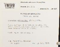 Anomodon attenuatus (Hedw.) Huebener 857420[1098810]Gerald A. Wheeler 301301981-07-11 United States, Minnesota, Saint Louis, About1.5 mi. N of Cotton on Rte. 53; E of road; S1/2 of SEction 3 |
MIN:Bryophytes |  Anomodon attenuatus (Hedw.) Huebener 852034[1098812]Frank D. Bowers 236091995-09-09 United States, Minnesota, Cook, Temperence River State Park; along river and falls; 1.2 km N of Schroeder on Hwy 61; T59 N, R4 W sec. 30 + sec. 31, 47.516667 -90.933333 |
MIN:Bryophytes | 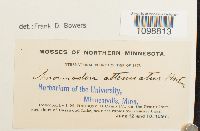 Anomodon attenuatus (Hedw.) Huebener 27920[1098813]J.M. Holzinger s.n.1897-06-12 United States, Minnesota, at Camp IV, on the Prairie Portage, shore of Basswood Lake, near the rapids from Sucker Lake. |
MIN:Bryophytes | 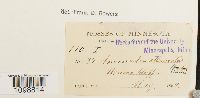 Anomodon attenuatus (Hedw.) Huebener 27922[1098814]J.M. Holzinger s.n.1894-05-00 United States, Minnesota, Winona bluffs |
MIN:Bryophytes | 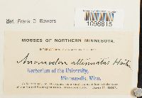 Anomodon attenuatus (Hedw.) Huebener 27925[1098815]J.M. Holzinger s.n.1897-06-11 United States, Minnesota, at the base of the United States peninsula, Basswood Lake |
MIN:Bryophytes | 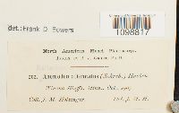 Anomodon attenuatus (Hedw.) Huebener 27924[1098817]J.M. Holzinger 2621905-10-00 United States, Minnesota, Winona Bluffs |
MIN:Bryophytes | 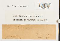 Anomodon attenuatus (Hedw.) Huebener 636747[1098819]J.M. Holzinger s.n.1893-05-06 United States, Minnesota |
MIN:Bryophytes |  Anomodon attenuatus (Hedw.) Huebener 636749[1098820]J.M. Holzinger s.n.1902-08-11 United States, Minnesota, Cook, The north shore of Lake Superior, Grand Portage island |
MIN:Bryophytes |  Anomodon attenuatus (Hedw.) Huebener 744272[1098821]Dale H. Vitt 268011981-07-28 United States, Minnesota, Lake, Gooseberry Falls on Hwy 61, Northwest shore of Lake Superior. Calcareous rock bluffs on North side of river, just west of road in Betula papyrifera, 47.083333 -91.366667 |
MIN:Bryophytes |  Anomodon attenuatus (Hedw.) Huebener 646623[1098822]J.M. Holzinger s.n.1899-08-07 United States, Minnesota |
1
Page 1, records 1-67 of 67
Google Map
Google Maps is a web mapping service provided by Google that features a map that users can pan (by dragging the mouse) and zoom (by using the mouse wheel). Collection points are displayed as colored markers that when clicked on, displays the full information for that collection. When multiple species are queried (separated by semi-colons), different colored markers denote each individual species.