University of Minnesota
http://www.umn.edu/
612-625-5000
http://www.umn.edu/
612-625-5000
Minnesota Biodiversity Atlas
Bell Museum
Dataset: All Collections
Taxa: Atrichum oerstedianum (Atrichum paraphyllium, Atrichum androgynum var. oerstedianum, Atrichum undulatum var. oerstedianum)
Search Criteria: Bell Museum bryophytes; Minnesota; excluding cultivated/captive occurrences
1
Page 1, records 1-8 of 8
Bell Museum bryophytes | |
 MIN:Bryophytes | 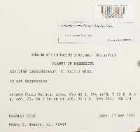 Atrichum oerstedianum (Müll. Hal.) Mitt. 852265[1099605]Frank D. Bowers 229371994-09-17 United States, Minnesota, Cook, Lutsen State Natural Area; ca 3 km NE of Jet. 36 & 61 (Hwy 61). NW 1/4, 47.75 -90.733333 |
MIN:Bryophytes | 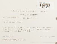 Atrichum oerstedianum (Müll. Hal.) Mitt. 853177[1099602]Frank D. Bowers 241541995-09-21 United States, Minnesota, Cook, Judge Magney State Park, area above Brule River (west) ; ca 24 km NE of Grand Marais, North of Devil's Kettle, 47.766667 -90.033333 |
MIN:Bryophytes | 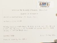 Atrichum oerstedianum (Müll. Hal.) Mitt. 852728[1099603]Frank D. Bowers 239881995-09-23 United States, Minnesota, Lake, Crosby-Manitow State Park, ca 12 km North of Little Marais, East of Hwy 7. Yellow Birch Area. Section 28 SE 1/4 and Section 32 SE 1/4. |
MIN:Bryophytes | 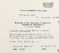 Atrichum oerstedianum (Müll. Hal.) Mitt. 857058[1099604]Gerald A. Wheeler 310601984-08-15 United States, Minnesota, Fillmore, Forestville State Park; about 7.5 mi. SW of Preston on Rte. 12 T102N R12W S1/2 of Sec. 13 |
MIN:Bryophytes |  Atrichum oerstedianum (Müll. Hal.) Mitt. 31400[1099599]J.M. Holzinger s.n.1890-07-20 United States, Minnesota, Washington, Marine Mills, St. Croix R. |
MIN:Bryophytes | 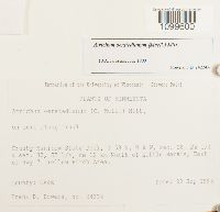 Atrichum oerstedianum (Müll. Hal.) Mitt. 852938[1099600]Frank D. Bowers 242241995-09-23 United States, Minnesota, Lake, Crosby-Manitow State Park. Sec. 28 SW 1/4 & Sec. 32 SE 1/4. ca 12 km North of Little Marais, East of Hwy 7. Yellow Birch Area. |
MIN:Bryophytes | 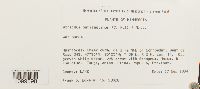 Atrichum oerstedianum (Müll. Hal.) Mitt. 852453[1099598]Frank D. Bowers 230281994-09-17 United States, Minnesota, Lake, Heartbreak Creek cRNA, ca S km NNE of Schroeder, west of Road 343., 47.583333 -90.916667 |
MIN:Bryophytes | 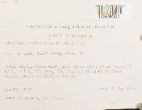 Atrichum oerstedianum (Müll. Hal.) Mitt. 853172[1099601]Frank D. Bowers 241761995-09-21 United States, Minnesota, Cook, Judge Magney State Park, area above Brule River (west), ca 24 km NE of Grand Marais, North of Devil's Kettle, 47.766667 -90.033333 |
1
Page 1, records 1-8 of 8
Google Map
Google Maps is a web mapping service provided by Google that features a map that users can pan (by dragging the mouse) and zoom (by using the mouse wheel). Collection points are displayed as colored markers that when clicked on, displays the full information for that collection. When multiple species are queried (separated by semi-colons), different colored markers denote each individual species.