University of Minnesota
http://www.umn.edu/
612-625-5000
http://www.umn.edu/
612-625-5000
Minnesota Biodiversity Atlas
Dataset: SMM
Search Criteria: United States OR USA OR U.S.A. OR United States of America; excluding cultivated/captive occurrences
Science Museum of Minnesota | |
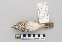
SMM | Z93:3:27[]Sonnens Pet Store 1987-05-12 United States, Minnesota, Ramsey, 406 St. Peter St. Hamm Bldg., 44.946341 -93.096493 |
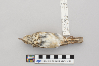
SMM | Z91:11:20[]R.J. Oehlenschlager 1991-05-12 United States, Minnesota, Ramsey, 30 E. 10th St., 44.9516 -93.102295 |
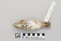
SMM | Z82:4:21[]Chase Davies 1965-04-01 United States, Minnesota, Ramsey, Interstate 35E North of junction 36, 45.022945 -93.089715 |
SMM | Z2002:1:129[] 2002-07-17 United States, Minnesota, Washington, on highway 95 between Stillwater and Marine on St. Croix |
SMM | Z2008:1:64[]Mark Edlund 2008-05-05 United States, Minnesota, Washington, Stonebridge Trail N., 45.096939 -92.818798 |
SMM | Z79:1:237[]Science Museum of Minnesota 1979-09-27 United States, Minnesota, Ramsey, 30 East 10th Street, 44.951522 -93.102546 |
SMM | Z83:36:26[] 1968-01-29 United States, Arizona, Pima, 12.5 mi N Tucson along Silverball Rd. |
SMM | Z83:36:30[]L.N.H. 1968-03-16 United States, Arizona, Pima, along Silverbell Rd. 8 mi North of Speedway, 32.283883 -111.052658 |
SMM | Z74:2:139[]Science Museum of Minnesota 1974-07-03 United States, Alaska, Steese Highway, near Eagle Summit, 65.484444 -145.403611 |
SMM | Z74:2:169[]Science Museum of Minnesota S0707131974-07-07 United States, Alaska, Steese Highway; Miller House Road, 65.557005 -145.099038 |
SMM | Z82:2:21[]H.F.K. 3301904-10-06 United States, Minnesota, Saint louis, 47.489629 -92.874534 |
SMM | Z87:9:32[]Richard Oehlenschlager B-241987-09-20 United States, Minnesota, Cook, 4.3 miles W of Sawbill trail on County Road 3, 47.806573 -90.970669 |
SMM | Z74:2:173[]Science Museum of Minnesota S0708091974-07-08 United States, Alaska, near Steese Highway, 65.405818 -145.884903 |
SMM | Z76:1:36[]Norm Johnson 1976-11-27 United States, Minnesota, Ramsey, 1367 Colby Ave, 44.907681 -93.189146 |
SMM | Z80:1:24[]Dan Koepp 1980-05-27 United States, Minnesota, Ramsey, Pets Unlimited Har Mar Mall |
SMM | Z2018:2:214[]Richard Oehlenschlager 2017-09-26 United States, Minnesota, Hennepin, Minneapolis Public Library, 44.980557 -93.270123 |
SMM | Z2018:2:19[]Kurt 1999-12-26 United States, Minnesota, Carver, Lowry Nature Center, 44.882535 -93.68354 |
SMM | Z96:18:2[]Richard Oehlenschlager B-5701996-06-28 United States, Minnesota, Ramsey, Twin Cities Army Ammunitions Plant, 45.097514 -93.162888 |
SMM | Z95:7:1[]Richard Oehlenschlager B-4621995-06-20 United States, Minnesota, Ramsey, Twin Cities Army Ammunition Plant, 45.097403 -93.162677 |
SMM | Z95:7:2[]Richard Oehlenschlager B-4611995-06-13 United States, Minnesota, Ramsey, Twin Cities Army Ammunition Plant, 45.097828 -93.163064 |
SMM | Z2000:1:48[] 2000-09-08 United States, Minnesota, Ramsey |
SMM | Z91:11:36[]Richard Oehlenschlager B-1831991-05-23 United States, Minnesota, Houston, Correy Creek Bottom, W side of MN 76, 1 mile N of turnoff to MLO Ranch, 43.878712 -91.611369 |
SMM | Z91:11:33[]Richard Oehlenschlager B-1791991-05-21 United States, Minnesota, Houston, ca 3 miles E of Caledonia; N side of MN 249 just below SCS earth dam, 43.634676 -91.436768 |
SMM | Z91:11:37[]Richard Oehlenschlager B-1841991-05-23 United States, Minnesota, Houston, Correy Creek Bottom, W side of MN 76, 1 mile N of turnoff to MLO Ranch, 43.87732 -91.610468 |
SMM | Z94:1:27[]Larry Smith 1992-07-09 United States, Minnesota, Anoka, 45.399032 -93.271075 |
SMM | Z90:7:34[]Richard Oehlenschlager B-1221990-08-30 United States, Minnesota, Houston, ca 3 miles E of Caledonia; N side MN249, just below SCS earth dam, 43.634428 -91.436768 |
SMM | Z91:11:40[]Richard Oehlenschlager B-1851991-05-24 United States, Minnesota, Houston, Correy Creek Bottom; W side of MN 76, 1 mile N of turnoff to MLO Ranch, 43.878371 -91.61124 |
SMM | Z91:11:41[]Richard Oehlenschlager B-1861991-05-24 United States, Minnesota, Houston, Storer Creek; just N of County Rd 21, 43.789097 -91.482928 |
SMM | Z91:11:39[]Richard Oehlenschlager B-1811991-05-23 United States, Minnesota, Houston, Correy Creek Bottom, W side of MN 76, 1 mile N of turnoff to MLO Ranch, 43.878124 -91.612099 |
SMM | Z91:11:38[]Richard Oehlenschlager B-1821991-05-23 United States, Minnesota, Houston, Correy Creek Bottom, W side of MN 76, 1 mile N of turnoff to MLO Ranch, 43.878 -91.611155 |
SMM | Z83:36:29[]B.A.F. 1965-09-00 United States, Wisconsin, Eau claire, TV Tower, 44.831917 -91.464813 |
SMM | Z2001:4:44[] 2001-08-09 United States, Minnesota, Carver, Lowry Nature Center |
SMM | Z2001:4:61[]James L. Smith 2001-05-29 United States, Minnesota, Isanti, Highway 65 S overpass, 45.559342 -93.218763 |
SMM | Z2018:2:152[]Dave Gardner 2010-09-04 United States, Minnesota, Ramsey, 45.058133 -93.042139 |
SMM | Z96:13:6[] 1996-07-11 United States, Minnesota, Washington, May Township; driveway to Warner Nature Center |
SMM | Z2008:1:3[]Richard Oehlenschlager 2008-09-08 United States, Minnesota, Washington, T31N R20W Sec. 32 NW 1/4 NW 1/4; DOR County Road 7, 45.136056 -92.873615 |
SMM | Z2018:2:49[]Richard Oehlenschlager B-1171990-06-29 United States, Minnesota, Wadena, T136N, R33W Sec. 11 NE 1/4 NW 1/4, 46.613761 -94.815933 |
SMM | Z96:13:1[]James Larry Smith 1996-05-20 United States, Minnesota, Anoka, 45.399936 -93.268758 |
SMM | Z96:18:3[]Richard Oehlenschlager B-5711996-06-28 United States, Minnesota, Ramsey, Twin Cities Army Ammunitions Plant, 45.097484 -93.163746 |
SMM | Z96:18:1[]Richard Oehlenschlager 1996-06-28 United States, min, ram, Twin Cities Army Ammunitions Plant, 45.098362 -93.162737 |
SMM | Z84:4:23[]H.F. Kendall 4991906-06-17 United States, Minnesota, Crow wing, Sec. 32-47-29, 46.470936 -93.899143 |
SMM | Z79:4:81[]C. Hadlund 1979-05-11 United States, Minnesota, Anoka, T33N R22W Sec. 26 NW; Carlos Avery Wildlife Management Area, 45.318797 -93.050506 |
SMM | Z84:4:32[] 1965-09-00 United States, Minnesota, Fillmore, Ostrander TV |
SMM | Z91:1:18[]Richard Oehlenschlager B-1741991-05-10 United States, Minnesota, Washington, May Township; Sec. 27 SW 1/4, 45.141847 -92.830465 |
SMM | Z2007:1:8[]James L. Smith 2007-05-18 United States, Minnesota, Anoka, 45.399819 -93.269103 |
SMM | Z2009:1:5[] 2009-08-26 United States, Minnesota, Anoka |
SMM | Z94:11:10[]Richard Oehlenschlager B-3741994-04-10 United States, Minnesota, Wadena, 46.638849 -94.880851 |
SMM | Z82:2:28[]J.H. Reisinger 1965-08-09 United States, Minnesota, Ramsey, 849 Tatum Street, 44.966569 -93.180127 |
SMM | Z95:9:17[]Richard Oehlenschlager 1995-03-19 United States, Minnesota, Hennepin, Dinkytown, 44.980702 -93.23581 |
SMM | Z74:2:164[]Science Museum of Minnesota S0707081974-07-07 United States, Alaska, Steese Highway on Miller House Road, 65.524167 -145.216111 |
SMM | Z74:2:134[]Science Museum of Minnesota S0703101974-07-03 United States, Alaska, Steese Highway near Eagle Summit, 65.484444 -145.403611 |
SMM | Z79:1:153[]Jan Fisher 1979-06-00 United States, Minnesota, Hennepin, 44.840798 -93.29828 |
SMM | Z2007:1:19[]R.J. Oehlenschlager 2007-09-10 United States, Minnesota, Ramsey, 360 St. Peter St, Lawson Sortware Bldg, 44.945032 -93.095113 |
SMM | Z82:2:93[]H.F. Kendall 1930-09-15 United States, Minnesota, Saint louis, 47.462428 -92.539906 |
SMM | Z82:2:91[]H.F. Kendall 1906-09-09 United States, Minnesota, Saint louis, 47.4167 -92.9333 |
SMM | Z82:2:90[]H.F.K. 1911-05-28 United States, Minnesota, 47.52326 -92.536571 |
SMM | Z97:15:10[]R.J. Oehlenschlager 1997-05-13 United States, Minnesota, Houston, Highway 61, 43.704269 -91.27105 |
SMM | Z82:2:96[]B.F. and P.T. 1965-09-00 United States, Wisconsin, Eau claire, Eau Claire TV Tower, 44.743111 -91.218343 |
SMM | Z2002:1:111[]R.J. Oehlenschlager 2002-09-11 United States, Minnesota, Ramsey, St. Paul Companies, 44.952255 -93.088107 |
SMM | Z2003:1:27[]Science Museum of Minnesota 2003-09-19 United States, Minnesota, Ramsey, 120 W. Kellogg blvd, The Science Museum of Minnesota, 44.9426 -93.098944 |
SMM | Z2007:1:15[]R.J. Oehlenschlager 2007-07-16 United States, Minnesota, Ramsey, Wabasha St. and 6th St., 44.946543 -93.095319 |
SMM | Z2003:1:30[]Richard Oehlenschlager 2003-10-10 United States, Minnesota, Ramsey, 120 W Kellogg Blvd, 44.942457 -93.098801 |
SMM | Z82:2:95[]B.A.F. 1965-09-00 United States, Wisconsin, Eau claire, TV Tower, 44.806509 -91.48329 |
SMM | Z2000:1:60[]R.J. Oehlenschlager 2000-10-02 United States, Minnesota, Ramsey, Ecolab Bldg, 44.94699 -93.09758 |
SMM | Z2002:1:85[]R.J. Oehlenschlager 2002-10-03 United States, Minnesota, Ramsey, St. Paul companies Bldg, 44.943993 -93.082613 |
SMM | Z86:6:4[]Curt 1983-10-26 United States, Minnesota, Ramsey, 30 E 10th Street; the Science Museum of Minnesota, 44.949651 -93.098236 |
SMM | Z86:6:16[] 1983-10-13 United States, Minnesota, Ramsey, 30 E 10th St. at Science Museum |
SMM | Z2005:1:34[]R.J. Oehlenschlager 2005-09-00 United States, Minnesota, Ramsey, 44.947152 -93.100123 |
SMM | Z82:2:97[]B.A.F. 1965-09-00 United States, Minnesota, Eau Claire, Tv tower, 44.827838 -91.493713 |
SMM | Z79:4:43[]C. Hadlund 1979-05-07 United States, Minnesota, Anoka, Carlos Avery Wildlife Management Area; T33N R22W Sec. 26 NW, 45.322297 -93.055999 |
SMM | Z82:2:99[]H.F.K. 1907-08-25 United States, Minnesota, 47.412983 -92.942913 |
SMM | Z73:10:81[] 1972-09-15 United States, Minnesota, Ramsey |
SMM | Z82:2:98[]R.G.K. 1931-06-08 United States, Minnesota, 47.465213 -92.551064 |
SMM | Z2003:1:36[]Richard Oehlenschlager 2003-06-01 United States, Minnesota, Wadena, T136N R33W Sec. 11 NWNW, 46.61382 -94.803745 |
SMM | Z2002:1:48[]R.J. Oehlenschlager 2002-05-24 United States, Minnesota, Wadena, 0.5 mi N Oylen, 46.581981 -94.80073 |
SMM | Z2001:4:4[]Mark Johnson 2001-05-10 United States, Minnesota, Kanabec, Comfort Township, within 5 miles of Moira, 45.862904 -93.207176 |
SMM | Z2007:1:18[] 2007-05-00 United States, Minnesota, Wadena |
SMM | Z2002:1:54[]Richard Oehlenschlager 2002-05-26 United States, Minnesota, Wadena, T136N R33W Sec. 10 NE SE, 46.605716 -94.82935 |
SMM | Z94:11:33[]Mark Spreyer 1994-05-15 United States, Minnesota, Scott, 44.712809 -93.43749 |
SMM | Z79:4:45[]C. Hadlund 1979-05-07 United States, Minnesota, Anoka, Carlos Avery Wildlife Management Area; T33N R22W Sec. 26 NW, 45.32272 -93.056428 |
SMM | Z2004:1:8[]Karen Terry 2004-05-15 United States, Minnesota, Otter tail, audrel Twp, 26156 Brekke, Lake Rd., 46.342846 -95.959901 |
SMM | Z93:3:32[]Richard Oehlenschlager B-3371993-05-09 United States, Minnesota, Wadena, T136N R33W Sec. 10 NW, 46.612556 -94.838921 |
SMM | Z89:13:6[] United States, Minnesota |
SMM | Z98:6:8[]Ron Lawrenz 1998-05-22 United States, Minnesota, Washington, 12020 182nd Street N; on Saint Croix River, 45.215719 -92.849293 |
SMM | Z2007:1:16[]John Oehlenshlager 2007-07-13 United States, Minnesota, Wadena, T136N R33W Sec11 SE NE, 46.610047 -94.803659 |
SMM | Z2003:1:35[]Science Museum of Minnesota 2003-07-28 United States, Minnesota, Ramsey, Xcel Energy Center, W Kellogg Blvd, 44.944917 -93.101177 |
SMM | Z79:4:80[]C. Hadlund 1979-05-11 United States, Minnesota, Anoka, Carlos Avery Wildlife Management Area; T33N R22W Sec27 NW; pool #4, 45.323761 -93.078061 |
SMM | Z94:14:1[]Richard Oehlenschlager B-4111994-09-09 United States, Minnesota, Cook, County Road 3, 1.3 miles W Sawbill trailside, 47.802169 -90.906141 |
SMM | Z93:3:56[]Glen T. Sawyer 1993-10-15 United States, Minnesota, Hennepin, 10631 Utica Road, 44.81082 -93.349162 |
SMM | Z86:9:7[] 1986-09-25 United States, Minnesota, Cook, Forest Road 153, 2.7 mile E Caribou Trail S side; site 60 |
SMM | Z91:10:30[]Richard Oehlenschlager B-2401991-09-21 United States, Minnesota, Cook, Forest Road 153, 2.3 miles E Caribou trail, S side; site 59, 47.860813 -90.575423 |
SMM | Z94:11:8[]Jane Olyphant 1994-10-05 United States, Minnesota, Washington, Lake Jane, 45.01515 -92.924355 |
SMM | Z93:3:62[]Patricia FreeBurg 1993-10-09 United States, Minnesota, Anoka, 5557 E Danube Road, 45.068605 -93.233557 |
SMM | Z85:14:2[]F.J. 1985-10-22 United States, Minnesota, Cook, Forest Road 153, 5.8 miles E junction with Caribou Trail, N side, 47.868815 -90.502831 |
SMM | Z88:14:19[] 1988-09-09 United States, Minnesota, Cook, SE intersection Forest Road 165 and Forest Road 339; site C3 |
SMM | Z91:10:29[]Richard Oehlenschlager B-2491991-09-22 United States, Minnesota, Cook, Forest Road 326, 2.5 miles N junction Forest Roads 153 and 165, W side; site 24, 47.895509 -90.646203 |
SMM | Z83:36:53[]Mudge Hawkinson 1982-05-00 United States, Minnesota, Ramsey, 4038 Valentine Court, 45.062961 -93.169615 |
SMM | Z84:2:30[]H.M. Parsons Jr. 1983-10-08 United States, Minnesota, Hennepin, 10639 Utica Circle, 44.810975 -93.348785 |
SMM | Z91:10:32[]Richard Oehlenschlager B-1971991-09-14 United States, Minnesota, Cook, Forest Road 165, 2.1 miles E of Baker Lake access road, S side, 47.815805 -90.843581 |
SMM | Z87:9:27[] 1987-09-24 United States, Minnesota, Cook, Forest Road 153, 2.1 miles W junction Forest Road 323, N side; site C31 |
Google Map
Google Maps is a web mapping service provided by Google that features a map that users can pan (by dragging the mouse) and zoom (by using the mouse wheel). Collection points are displayed as colored markers that when clicked on, displays the full information for that collection. When multiple species are queried (separated by semi-colons), different colored markers denote each individual species.
