University of Minnesota
http://www.umn.edu/
612-625-5000
http://www.umn.edu/
612-625-5000
Minnesota Biodiversity Atlas
Dataset: MIN-Plants
Taxa: Araceae
Search Criteria: excluding cultivated/captive occurrences
Bell Museum plants | |
 MIN:Plants |  Arisaema triphyllum (L.) Schott 777631[1335203]Coffin, Barbara; Engstrom, D. 84-71984-06-26 United States, Minnesota, Cook, Cook Co.; Hovland Lookout Tower. T62N R4W sec. 6;Superior National Forest;062N;04W;6, 47.881195 -90.883701 |
MIN:Plants |  Arisaema triphyllum (L.) Schott 777634[1335201]Coffin, Barbara; Engstrom, D. 83-681983-06-09 United States, Minnesota, Cook, Cook Co.; T62N R2E, sec.13 SW1/4 of NW1/4; Bogus Tower Area, near Grand Marais. Superior National Forest.;Superior National Forest;062N;02E;13, 47.852523 -90.136151 |
MIN:Plants |  Arisaema triphyllum (L.) Schott 777644[1335202]Coffin, Barbara; Engstrom, D. 82-701982-06-16 United States, Minnesota, Cook, Cook Co.; Hovland Lookout - on SE facing slope below forestry tower. T62N R3E Sec. 1;North Shore / Spring Beauty Northern Hardwoods Scientific Natural Area;062N;03E;1, 47.881408 -90.007702 |
MIN:Plants |  Arisaema triphyllum (L.) Schott 777670[1335207]Coffin, Barbara; Engstrom, D. 83-401983-06-08 United States, Minnesota, Cook, Cook Co.; Yellow Birch Study Area, Superior National Forest. T60N R5W Sec. 36;Superior National Forest;060N;05W;36, 47.637566 -90.905587 |
MIN:Plants |  Arisaema triphyllum (L.) Schott 777679[1335018]Coffin, Barbara 83-371983-06-07 United States, Minnesota, Cook, Cook Co.; Cross River, Superior National Forest. T59N R5w Sec. 10;Superior National Forest;059N;05W;10, 47.608849 -90.948106 |
MIN:Plants |  Arisaema triphyllum (L.) Schott 781265[1335222]Smith, Welby 93231984-06-23 United States, Minnesota, Mower, Mower Co.; Lake Louise State Park, about 1 mile N-NW of LeRoy. Banks of the Upper Iowa River. Section 28, T101N R14W;Lake Louise State Park;101N;14W;28, 43.522099 -92.518958 |
MIN:Plants |  Arisaema triphyllum (L.) Schott 782624[1335240]Tenney, M. 2191982-06-17 United States, Minnesota, Fillmore, Forestville State Park. Fillmore Co. T102N R11W Sec.18 NW1/4 SW1/4 NW1/4;Forestville State Park;102N;11W;18, 43.637926 -92.199183 |
MIN:Plants |  Arisaema triphyllum (L.) Schott 782645[1335234]Tenney, M. 2001982-06-14 United States, Minnesota, Winona, Whitewater State Park. Winona Co.; T107N R10W;Whitewater State Park;107N;10W;, 44.063442 -92.019259 |
MIN:Plants |  Arisaema triphyllum (L.) Schott 787537[1335136]Smith, Welby 100841985-05-03 United States, Minnesota, Fillmore, Dorer Memorial Hardwood State Forest. Fillmore County ... Along the South Branch Root River, about 3 mi northwest of Greenleafton... T102N R12W NE1/4 of NW1/4 of Sec 26.. 102N 12W 26, 43.6152763 -92.2422256 |
MIN:Plants |  Arisaema triphyllum (L.) Schott 788892[1335123]Smith, Welby 103211985-05-30 United States, Minnesota, Le Sueur, Le Sueur County ... Richter Woods County Park, about 2 mi W of Montgomery ... T11N R23W NW1/4 SE1/4 sec.8;Richter Woods County Park;111N;23W;8, 44.4333344 -93.6138916 |
MIN:Plants |  Arisaema triphyllum (L.) Schott 789596[1335181]Smith, Welby 101651985-05-27 United States, Minnesota, Hennepin, Hennepin Co.; Wolsfeld Woods State Scientific and Natural Area, about 2 1/2 miles west of Plymouth. Sec. 27, T118N R23W;Wolsfeld Woods SNA;118N;23W;27, 44.999919 -93.573712 |
MIN:Plants |  Arisaema triphyllum (L.) Schott 795688[1335126]Larson, I. 61975-05-25 United States, Minnesota, Traverse, Traverse Co.; Near Lake Traverse, on woodlot of the Ole Larson property.;;;;, 45.685453 -96.760254 |
MIN:Plants |  Arisaema triphyllum (L.) Schott 800193[1335097]Cholewa, A. 16001989-05-23 United States, Minnesota, Washington, Carpenter Nature Center. Washington Co, T26N R20W S4...North Ravine, base of NE-facing slope above waterfall.;Carpenter Nature Center;026N;20W;04, 44.768807 -92.813616 |
MIN:Plants |  Arisaema triphyllum (L.) Schott 803042[1335101]Smith, Welby 117761986-06-14 United States, Minnesota, Olmsted, Oxbow County Park. Olmsted County ... Oxbow County Park, about 3 mi. north of Byron ... overlooking the Zumbro River ... NW1/4 NW1/4 sec.17, T107N R15W. 107N 15W 17, 44.0769463 -92.6538925 |
MIN:Plants |  Arisaema triphyllum (L.) Schott 803052[1335122]Smith, Welby 116161986-06-03 United States, Minnesota, Mower, Brandt-Larson Wildlife Management Area. Mower Co.; Brandt-Larson State Wildlife Management Area, about 4 miles northeast of Lyle. Along Otter Creek. Section 16, Mower Co.; Brandt-Larson State Wildlife Management Area, about 4 miles northeast of Lyle. Along Otter Creek. Section 16, T101N R17W. 101N 17W 16, 43.550746 -92.878835 |
MIN:Plants |  Arisaema triphyllum (L.) Schott 806933[1335023]Siemers, Ross 31977-06-06 United States, Minnesota, Stearns, Stearns Co. Rockville Tamarack Bog Preserve.;Rockville Tamarack Bog;123N;29W;17, 45.464811 -94.353471 |
MIN:Plants |  Arisaema triphyllum (L.) Schott 812762[1335098]Wheeler, Gerald 105131988-05-26 United States, Minnesota, Norman, Norman Co.; Ca. 2 miles north of Faith; about 0.5 mile west of Rte. 40. Section 2, T144N R43W;;144N;43W;2, 47.318097 -96.098758 |
MIN:Plants |  Arisaema triphyllum (L.) Schott 814751[1335100]Wheeler, Gerald 114721988-07-27 United States, Minnesota, Lac Qui Parle, Lac Qui Parle Co.; Ca. 6 mi NNE of Bellingham; Lac Qui Parle WMA. Bordering Minnesota River. Sect. 12 T 120N R 45W;Lac Qui Parle Wildlife Management Area;120N;45W;12, 45.214682 -96.23671 |
MIN:Plants |  Arisaema triphyllum (L.) Schott 817469[1311604]Engels, A. s.n.1991-05-16 United States, Minnesota, Aitkin, Aitkin Co. T49N, R25W, Sec28, ca. 2 mi SW of Palisade.;;049N;25W;28, 46.703158 -93.516482 |
MIN:Plants |  Arisaema triphyllum (L.) Schott 826173[1335137]Bender, J. s.n.1986-05-02 United States, Minnesota, Washington, Washington Co, Afton twp.; Valley Branch Creek;Belwin Outdoor Education Laboratory;028N;20W;, 44.907173 -92.81202 |
MIN:Plants |  Arisaema triphyllum (L.) Schott 829309[1311605]Myhre, K. 19001992-05-25 United States, Minnesota, Cass, Cass Co. Located near Cedar Creek in the Foothills State Forest; T138N R31W NW1/4 of SE1/4 of Sec 27;Foothills State Forest;138N;31W;27, 46.739552 -94.587919 |
MIN:Plants |  Arisaema triphyllum (L.) Schott 829541[1311603]Boe, J. 920623141992-06-23 United States, Minnesota, Roseau, Roseau Co.; N of Roosevelt; SE1/4 NE1/4 Sec.25 T162N R35W.;;162N;35W;25, 48.821707 -95.101713 |
MIN:Plants |  Arisaema triphyllum (L.) Schott 831630[1335094]Harris, Fred 920191992-06-03 United States, Minnesota, Marshall, Marshall Co.; first terrace on E bank of Red River; SW1/4 SW1/4 Sec.22 T156N R50W;;156N;50W;22, 48.318377 -97.075965 |
MIN:Plants |  Arisaema triphyllum (L.) Schott 833920[1335099]Smith, Welby 140621988-05-20 United States, Minnesota, Kanabec, Kanabec County ... On the W side of the Snake River, just S of the Hwy 3 crossing ... NE1/4 NW1/4 sec 22 T 41N R23W;;041N;23W;22, 46.0238876 -93.2333298 |
MIN:Plants |  Arisaema triphyllum (L.) Schott 834174[1335093]Smith, Welby 197041991-07-18 United States, Minnesota, Roseau, Roseau County ... On the side side of Elm Point in Lake of the Woods, about 0.25 mi south of the international border ... T164N R36W NE1/4 of NE1/4 of Sec 28. 164N 36W 28, 48.9958344 -95.2916641 |
MIN:Plants |  Arisaema triphyllum (L.) Schott 834900[1311610]Haferman, J. 591995-05-19 United States, Minnesota, Scott, Scott Co. T115N R22W S36 SW of SW. Approx. 0.1 miles north-northeast of intersection of State Highway 13 and County Road Scott Co. T115N R22W S36 SW of SW. Approx. 0.1 miles north-northeast of intersection of State Highway 13 and County Road 44 on north side of hwy. 115N 22W 36, 44.724586 -93.409031 |
MIN:Plants |  Arisaema triphyllum (L.) Schott 835411[1335129]Monson, Paul 54831983-06-20 United States, Minnesota, Saint Louis, Voyageur's National Park. St. Louis Co. R-21W, T-69N, S-19. Kabetogama Road, 4 mi N of Hwy.53; E side of road;Voyageurs National Park;069N;21W;19, 48.450516 -93.080987 |
MIN:Plants |  Arisaema triphyllum (L.) Schott 835679[1311607]Cholewa, A.; Engels, A. 21391995-05-18 United States, Minnesota, Aitkin, Savanna Portage State Park. Aitkin Co. Savanna Portage State Park, about 17 mi NE of McGregor, Group Camp on Savanna Lake, T50N R22W S6 NE1/4 of SW1 Aitkin Co. Savanna Portage State Park, about 17 mi NE of McGregor, Group Camp on Savanna Lake, T50N R22W S6 NE1/4 of SW1/4. 050N 20W 6, 46.845996 -93.17745 |
MIN:Plants |  Arisaema triphyllum (L.) Schott 840667[1335121]Smith, Welby 126951987-05-16 United States, Minnesota, Goodhue, Goodhue County...Hay Creek Recreation Area, about 2 mi S of Red Wing...NE1/4 NE1/4 sec.12, T112N R15W;Dorer Memorial Hardwood State Forest;112N;15W;12, 44.5247231 -92.5538864 |
MIN:Plants |  Arisaema triphyllum (L.) Schott 84375[1335287]Moore, W. s.n.1907-05-30 United States, Minnesota, Hennepin, Hennepin Co.; Spring Park.;;117N;23W;, 44.934923 -93.584208 |
MIN:Plants |  Arisaema triphyllum (L.) Schott 84396[1335247]Goldsmith, G. s.n.1885-05-24 United States, Minnesota, Carlton Lake.;;;;, 44.919005 -95.70981 |
MIN:Plants |  Arisaema triphyllum (L.) Schott 84397[1335070]Manning, Sara s.n.1883-06-29 United States, Minnesota, Wabasha, Lake City;;111N;12W;, 44.4081 -92.252454 |
MIN:Plants |  Arisaema triphyllum (L.) Schott 84398[1335264]Rosendahl, C.; Butters, F. 35921918-07-08 United States, Minnesota, Mille Lacs, Cove Bay, Mille Lacs. Mille Lacs Co.;;042N;26W;, 46.11234 -93.620504 |
MIN:Plants |  Arisaema triphyllum (L.) Schott 84399[1335270]Skinner, S. 1441902-06-19 United States, Minnesota, Jackson, Jackson Co.; Heron Lake Region. Banks of the Des Moines River.;;;;, 43.794959 -95.320276 |
MIN:Plants |  Arisaema triphyllum (L.) Schott 84401[1335304]Sheldon, Edmund S21031892-06-00 United States, Minnesota, Aitkin, Nichols;;044N;27w;04, 46.326835 -93.784934 |
MIN:Plants |  Arisaema triphyllum (L.) Schott 84403[1335267]Sandberg, John s.n.1882-05-00 United States, Minnesota, Goodhue, Goodhue Co. Vasa;Dorer Memorial Hardwood State Forest;112N;16W;15, 44.507076 -92.722 |
MIN:Plants |  Arisaema triphyllum (L.) Schott 84405[1335237]Aiton, G. s.n.1879-05-00 United States, Minnesota, Nicollet, Nicollet Co.;;;;, 44.368476 -94.348877 |
MIN:Plants |  Arisaema triphyllum (L.) Schott 84406[1335236]Arthur, J.; et al. 156A1886-07-24 United States, Minnesota, Saint Louis, Vermilion Lake;;;;, 47.89167 -92.36667 |
MIN:Plants | Arisaema triphyllum (L.) Schott 84408[]MacMillan, C.; et al. 237Sk1900-08-00 United States, Minnesota, Polk, Crookston.;;150N;46W;30, 47.782001 -96.600066 |
MIN:Plants |  Arisaema triphyllum (L.) Schott 84409[1335314]Campbell, Jennie C41896-07-00 United States, Minnesota, Stearns, Grand Lake, Stearns Co.;;123N;29W;, 45.45742 -94.322478 |
MIN:Plants |  Arisaema triphyllum (L.) Schott 84410[1335266]Sandberg, John s.n.1890-06-00 United States, Minnesota, Hennepin, Henn. Co.;;;;, 45 -93.47 |
MIN:Plants |  Arisaema triphyllum (L.) Schott 84411[1335279]Frost, W. F651892-06-00 United States, Minnesota, Meeker, Litchfield;;119N;31W;, 45.12722 -94.52778 |
MIN:Plants |  Arisaema triphyllum (L.) Schott 84412[1335313]Taylor, B. 432a1891-06-00 United States, Minnesota, Waseca, Janesville;;108N;24W;, 44.152568 -93.70784 |
MIN:Plants |  Arisaema triphyllum (L.) Schott 84413[1335280]Ballard, C. B581891-06-00 United States, Minnesota, Carver, Chaska;;;;, 44.789407 -93.602179 |
MIN:Plants |  Arisaema triphyllum (L.) Schott 84414[1335305]Sheldon, Edmund S29801892-07-00 United States, Minnesota, Mille Lacs, Milaca;;038N;26W;, 45.777674 -93.576336 |
MIN:Plants |  Arisaema triphyllum (L.) Schott 84415[1335319]Burglehaus, F. s.n.1891-06-05 United States, Minnesota, Hennepin, Hennepin Co.;;;;, 45 -93.47 |
MIN:Plants |  Arisaema triphyllum (L.) Schott 84416[1335271]Kassube, J. s.n.1878-05-00 United States, Minnesota, Hennepin, Minneapolis.;;;;, 44.979965 -93.263836 |
MIN:Plants |  Arisaema triphyllum (L.) Schott 84417[1335301]McElligott, T. s.n.1890-05-08 United States, Minnesota, McLeod, Glencoe;;115N;28W;, 44.76151 -94.192838 |
MIN:Plants |  Arisaema triphyllum (L.) Schott 84418[1335110]Herrick, C. s.n.1878-05-00 United States, Minnesota, Hennepin, Minneapolis;;;;, 44.979965 -93.263836 |
MIN:Plants |  Arisaema triphyllum (L.) Schott 84490[1335265]Ainslie, G. 876 United States, Minnesota, Olmsted, Near Rochester;;106N;14W;00, 43.97834 -92.498342 |
MIN:Plants |  Arisaema triphyllum (L.) Schott 84492[1335248]Wheeler, William 10611901-09-10 United States, Minnesota, Rock, Luverne. Rock Co.;;102N;45W;, 43.630871 -96.232681 |
MIN:Plants |  Arisaema triphyllum (L.) Schott 84494[1335246]Sheldon, Edmund s.n.1895-05-00 United States, Minnesota, Ramsey, Ramsey Co.; On Larson Island.;;;;, 45.018032 -93.092742 |
MIN:Plants |  Arisaema triphyllum (L.) Schott 461223[1335320]Gerdes, Lynden; et al. 24631998-05-22 United States, Minnesota, Cook, T64N R03E S03NWNE. Cook County; Superior National Forest, BWCAW. In vic. of portage between John Lake & the Royal River;Boundary Waters Canoe Area Wilderness / Superior National Forest;064N;03E;3, 48.057476 -90.04601 |
MIN:Plants |  Arisaema triphyllum (L.) Schott 476692[1335016]Kaul, R. 63931989-06-15 United States, Minnesota, Clearwater, Clearwater County ... east side of Lake Itasca.;Itasca State Park;143N;36W;, 47.19557 -95.233216 |
MIN:Plants |  Arisaema triphyllum (L.) Schott 896537[1335078]Rowe, Erika ERR20060726072006-07-26 United States, Minnesota, Becker, Becker County...north edge of Buffalo River...NESE S17 T140N R43W;;140N;43W;17, 46.9416667 -96.1369444 |
MIN:Plants |  Arisaema triphyllum (L.) Schott 912851[1335076]Smith, Welby 242091994-05-31 United States, Minnesota, Koochiching, Franz Jevne State Park. Koochiching County...Franz Jevne State Park. In the Rainy River Valley, about 2 miles northeast of Birchdale... T160N R27W SW1/4 of SW1/4 of Sec 26. 160N 27W 26, 48.6427778 -94.0783333 |
MIN:Plants |  Arisaema triphyllum (L.) Schott 511060[1335130]Wheeler, Gerald 157111997-05-24 United States, Minnesota, Nicollet, Fort Ridgely State Park. Nicollet County ... Fort Ridgely State Park; 0.6 mi. NW of jct. of Rte. 4 and Rte. 5 ... W1/2 NE1/4 NE1/4 Sec. 6 T111N R32W (Ridgely 6). 111N 32W 6, 44.442137 -94.736857 |
MIN:Plants |  Arisaema triphyllum (L.) Schott 427361[1335197]Gellerman, Joanne 011-A JLG1994-05-10 United States, Minnesota, Freeborn, Myre Big Island State Park. Myre Big Island State Park. Freeborn Co.; T: 102N R: 21W Sec: 24 Quater Sec: NE. 12 yards from campground road opposite (south) of site #24 sign.. 102N 21W 24, 43.622355 -93.298697 |
MIN:Plants | Arisaema triphyllum (L.) Schott 443433[]US Nat. Arboretum staff 231978-00-00 United States, District of Columbia, National Arboretum;;;;, 38.91039 -76.966086 |
MIN:Plants |  Arisaema triphyllum (L.) Schott 508817[1335195]Wheeler, Gerald 188011998-05-27 United States, Minnesota, Meeker, Ca. 3.5 mi. NW of Dassel. (Dassel Township). N1/2 NW1/4 NW1/4 of section;;119N;29W;17, 45.116786 -94.347745 |
MIN:Plants |  Arisaema triphyllum (L.) Schott 599380[1335422]Tryon, R. 45821936-05-17 United States, Indiana, Porter, Indiana Dunes State Park, 3 miles N of Chesterton, Porter Co.;Indiana Dunes National Lakeshore;;;, 41.654063 -87.064199 |
MIN:Plants |  Arisaema triphyllum (L.) Schott 499455[1335242]McNaughton, Lynn 119A2003-05-16 United States, Minnesota, Waseca, Maplewood Park: Waseca County ... NE1/4 of SW1/4 of Sect. 9, T107N, R22W.;Maplewood County Park;107N;22W;09, 44.08766 -93.47676 |
MIN:Plants |  Arisaema triphyllum (L.) Schott 453934[1335294]Juhnke, C. 200 CMJ FRO1999-05-11 United States, Minnesota, Goodhue, Frontenac State Park Goodhue County ... self-guided trail woodland at quarry ...T112N R13W NE NW SE 2;Frontenac State Park;112N;13W;2, 44.535072 -92.339158 |
MIN:Plants |  Arisaema triphyllum (L.) Schott 427162[1335196]Gellerman, Joanne 011-B JLG1994-05-10 United States, Minnesota, Freeborn, Myre Big Island State Park. Myre Big Island State Park. Freeborn Co.; T: 102N R: 21W Sec: 24 Quarter sec: NE. 12 yards from campground road opposite (south) of site #24 sign.. 102N 21W 24, 43.622355 -93.298697 |
MIN:Plants | 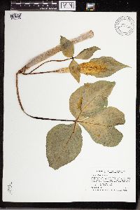 Arisaema triphyllum (L.) Schott 913221[1335074]Smith, Welby 240931994-05-16 United States, Minnesota, Murray, Lake Shetek State Park. Murray County ... Lake Shetek State Park, about 3 miles northwest of Currie ... Loon Island in Lake Shetek ... T107N R40W SW1/4 of SW1/4 of Sec 31. 107N 40W 31, 44.1111111 -95.7011111 |
MIN:Plants | 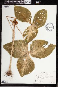 Arisaema triphyllum (L.) Schott 476697[1335017]Seevers, K. s.n.1983-09-22 United States, Minnesota, Winona, 1-1/2 miles north, 1/2 mile west of headquarters to Whitewater State Park. Winona Co.;Whitewater State Park;107N;10W;, 44.063442 -92.019259 |
MIN:Plants | 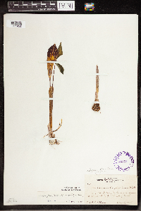 Arisaema triphyllum (L.) Schott 295311[1335424]Benner, F.R. 1631928-05-19 United States, Wisconsin, Polk, 2.8 mi N. St. Croix Falls, Wis. on River road, just S. of Whiskey Creek.;Saint Croix National Riverway;;;, 45.090547 -92.4333 |
MIN:Plants | 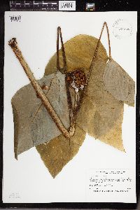 Arisaema triphyllum (L.) Schott 923879[1335143]Smith, Welby 216771992-08-26 United States, Minnesota, Nicollet, About 7 miles north of Mankato; bank of Seven Mile Creek. NW1/4 of NE1/4 of section.;Seven Mile Creek County Park;109N;27W;11, 44.2680556 -94.0344444 |
MIN:Plants |  Arisaema triphyllum (L.) Schott 922446[1335144]Smith, Welby 234431993-08-10 United States, Minnesota, Cottonwood, About 6 miles north-northwest of Storden, along Dutch Charley Creek. SW1/4 of NE1/4 of Sec;;108N;38W;36, 44.1194444 -95.3513889 |
MIN:Plants |  Arisaema triphyllum (L.) Schott 934836[1335229]Whitfeld, T. J. S.; et al. 8632012-05-01 United States, Minnesota, Washington, St. Croix Watershed Management Research Station, Washington County;;;;, 45.03333 -92.91667 |
MIN:Plants |  Arisaema triphyllum (L.) Schott 937566[1335142]Gerdes, Lynden B. 65062012-06-05 United States, Minnesota, Lake, Approximately 16.54 miles NE of Ely, MN and 0.24 miles west of Secret Lake along small drainage intersecting the hiking trail.;Superior National Forest;064N;09W;32, 47.981111 -91.501944 |
MIN:Plants |  Arisaema triphyllum (L.) Schott 951424[1290514]Anonymous s.n.1879-05-07 United States, Minnesota, near Dead Lake, 46.717645 -95.555118 |
MIN:Plants |  Arisaema triphyllum (L.) Schott 938684[1292849]Kerns, Courtney CKK0043 United States, Minnesota, Beltrami, 48.107881 -94.522402 |
MIN:Plants |  Arisaema triphyllum (L.) Schott 480016[1292975]Lowli,Nellie s.n.1896-05-13 United States, Iowa, Sugar Creek |
MIN:Plants |  Arisaema triphyllum (L.) Schott 959079[1305306]Lynden B. Gerdes 72152015-06-15 United States, Minnesota, Koochiching, Approximately 6.51 miles NE of Ray, MN and 0.81 miles west of St. Louis Cty. Rd 122., 48.47416667 -93.09722222 |
MIN:Plants |  Arisaema triphyllum (L.) Schott 959342[1311183]Lynden B. Gerdes 73152015-07-23 United States, Minnesota, Koochiching, Approximately 7.70 miles southwest of Ray, MN and 1.92 miles NW of the Haney Road & Burdis Road intersection., 48.31916667 -93.29666667 |
MIN:Plants |  Arisaema triphyllum (L.) Schott 84498[1335274][illegible], C. Mar 2371900-08-00 United States, Minnesota, Polk |
MIN:Plants |  Arisaema triphyllum (L.) Schott 937406[1335356]Miller, James S. 83621994-08-11 United States, Tennessee, Cocke, Cherokee National Forest, 35.47 83, 970m |
MIN:Plants |  Arisaema triphyllum (L.) Schott 934168[1335357]Boufford, D. E. 209601979-05-16 United States, Tennessee, Johnson, 3.5 km (2.2 miles) S of the Virginia state line on Tennessee route 91; N of the town of Laurel Bloomery. Streamside forest along Laurel Creek., 36.588757 -81.75412 |
MIN:Plants |  Arisaema triphyllum (L.) Schott 389575[1335358]Zenkert, Charles A. s.n.1929-06-16 United States, New York, Eerie, East Concord, 42.55 -78.6333 |
MIN:Plants |  Arisaema triphyllum (L.) Schott 441600[1335360]Hunnewell, F. W. 120281931-06-13 United States, Maine, Oxford |
MIN:Plants |  Arisaema triphyllum (L.) Schott 581361[1335363]Dutton, D. L. s.n.1925-06-20 United States, Vermont, Addison, Scanlon Swamp, 43.866729 -73.107891 |
MIN:Plants |  Arisaema triphyllum (L.) Schott 304464[1335365]Smith, Benjamin H. s.n.1902-05-30 United States, North Carolina, Martin |
MIN:Plants |  Arisaema triphyllum (L.) Schott 84372[1335369]Fernald, M. L. 164941918-08-17 United States, Massachusetts, Barnstable |
MIN:Plants |  Arisaema triphyllum (L.) Schott 702854[1335370]Herny, Leroy K. s.n.1953-06-11 United States, Pennsylvania, Crawford, Hartstown, Mud Lake, 41.552554 -80.379233 |
MIN:Plants |  Arisaema triphyllum (L.) Schott 618350[1335373]Long, R. W. 318181969-02-10 United States, Florida, Collier, Little Hickory Pass, North Naples, 26.310918 -81.837588 |
MIN:Plants |  Arisaema triphyllum (L.) Schott 509089[1335375]Williams, C. L. 1951-04-17 United States, Louisiana, Lincoln, near D'Arbonne Bayou, 32.6667 -92.4667 |
MIN:Plants |  Arisaema triphyllum (L.) Schott 336156[1335383]Gilbert, F. A. 4511930-05-19 United States, West Virginia, Wayne, Near Hubbard's Branch, 38.392167 -82.538135 |
MIN:Plants |  Arisaema triphyllum (L.) Schott 366643[1335385]Weatherby, C.A. 10261932-05-28 United States, Connecticut, New London, North Stonington, 41.440932 -71.881183 |
MIN:Plants |  Arisaema triphyllum (L.) Schott 567273[1335386]Hunnewell, F. W. 66431920-05-28 United States, District of Columbia |
MIN:Plants |  Arisaema triphyllum (L.) Schott 84382[1335389]Topping, D. LeRoy s.n.1895-05-29 United States, District of Columbia, Argyle Estate |
MIN:Plants |  Arisaema triphyllum (L.) Schott 523507[1335390]Cooper, W. S. s.n.1902-05-10 United States, Michigan, Wayne |
MIN:Plants |  Arisaema triphyllum (L.) Schott 444560[1335392]Abbot, Robinson S. s.n.1947-04-30 United States, Pennsylvania, Northumberland, Montandon, 40.965363 -76.850798 |
MIN:Plants |  Arisaema triphyllum (L.) Schott 358608[1335393]Elliot, F. M. s.n. United States, Illinois |
MIN:Plants |  Arisaema triphyllum (L.) Schott 242460[1335394]C. S. H. 156221918-05-10 United States, New York, Long Island, west side of cold spring marsh, 40.816765 -73.06622 |
MIN:Plants |  Arisaema triphyllum (L.) Schott 386650[1335396]Chrysler, M. A. s.n.1941-05-24 United States, New Jersey, Morris, North of Chester, 40.784267 -74.696828 |
MIN:Plants |  Arisaema triphyllum (L.) Schott 406489[1335397]Chase, Virginius H. 30881919-05-25 United States, Illinois, Peoria |
MIN:Plants |  Arisaema triphyllum (L.) Schott 288583[1335399]Kleinhoonte, A. s.n.1913-06-01 United States, Illinois, Naperville Park, 41.750986 -88.153575 |
MIN:Plants |  Arisaema triphyllum (L.) Schott 84391[1335400]Fernald, Geo. B s.n.1896-05-22 United States, Maine, Dover, 43.923136 -69.637824 |
MIN:Plants |  Arisaema triphyllum (L.) Schott 84379[1335401]Davis, Charles A. s.n. United States, Michigan, Gratiot, Alma, 43.37892 -84.659727 |
Google Map
Google Maps is a web mapping service provided by Google that features a map that users can pan (by dragging the mouse) and zoom (by using the mouse wheel). Collection points are displayed as colored markers that when clicked on, displays the full information for that collection. When multiple species are queried (separated by semi-colons), different colored markers denote each individual species.