University of Minnesota
http://www.umn.edu/
612-625-5000
http://www.umn.edu/
612-625-5000
Minnesota Biodiversity Atlas
Bell Museum
Dataset: MIN-Plants
Search Criteria: Nicaragua; excluding cultivated/captive occurrences
Bell Museum plants | |
 MIN:Plants |  Sideroxylon portoricense minutiflorum (Pittier) T.D. Pennington 454561[1299053]Guzman, M.; Castro, D. 21431981-10-22 Nicaragua, Jinotega, Carretera Matagalpa-Jinoega, Km 145, 1400m |
MIN:Plants | Diospyros nigra (J.F. Gmel.) Perr. 461014[]Robleto, Walter 20061985-06-02 Nicaragua, Rivas, Isla Ometepe - Volcan Maderas, localidad de "Las Cuchillas".;;;;, 11.45 -85.4666667, 400 - 800m |
MIN:Plants |  461022[1353399]Rueda, R.; et al. 16401994-07-03 Nicaragua, Rio San Juan. Pueblo de Graytown nuevo;;;;, 10.9333333 -83.7666667 |
MIN:Plants | Diospyros nigra (J.F. Gmel.) Perr. 461015[]Robleto, Walter 20501985-06-03 Nicaragua, Rivas, Isla Ometepe - Volcan Maderas, localidad de "Las Cuchillas".;;;;, 11.4333333 -85.4833333, 300 - 400m |
MIN:Plants | Solanum lanceolatum Cavanilles 488015[]Grijalva, A.; Araquistain, M. 6361979-10-19 Nicaragua, Esteli, Cerro Quiabu, situado a unos 8 kms NO de la ciudad de Esteli, 1500 - 1600m |
MIN:Plants |  Manilkara chicle (Pittier) Gilly 455066[1299054]Stevens, Warren Douglas 225931983-12-18 Nicaragua, Chontales, along road between Rio Bizcocho and Rio El Jordan (near confluence with Rio La Pradera);;;;, 12.25 -85.2666702, 350 - 550m |
MIN:Plants | Tillandsia fasciculata Swartz 515258[]Stevens, Warren Douglas; et al. 144781979-10-01 Nicaragua, Esteli, Salto de Estanzuela, Rio Estanzuela ca 6 km S of Esteli;;;;, 13.0166664 -86.3333359, 920 - 1020m |
MIN:Plants | Solanum lanceolatum Cavanilles 488013[]Moreno, Pedro; et al. 204021983-02-22 Nicaragua, Matagalpa, Km 136, entre Matagalpa y Jinotega;;;;, 12.4166667 -85.9166667, 1000 - 1200m |
MIN:Plants |  Solanum nicaraguense Rydberg 229765[1002437]Flint [?], C. s.n.0000-00-00 Nicaragua, [no further data] |
MIN:Plants | Erythroxylum havanense Jacq. 489246[1299638]Stevens, Warren Douglas Nicaragua, Detailed locality information protected. This is typically done to protect rare or threatened species localities. |
MIN:Plants | Dichaea glauca Lindl. 925271[1310193]Rueda, R. Nicaragua, Jinotega, Detailed locality information protected. This is typically done to protect rare or threatened species localities. |
MIN:Plants | Dichaea graminoides Lindl. 925272[1310195]Rueda, R.M. Nicaragua, Jinotega, Jinotega, Detailed locality information protected. This is typically done to protect rare or threatened species localities. |
MIN:Plants | Dichaea muricatoides Hamer & Garay in Hamer 925269[1310197]Rueda, R. Nicaragua, Jinotega, Detailed locality information protected. This is typically done to protect rare or threatened species localities. |
MIN:Plants | 925270[1310229]Rueda, R. Nicaragua, Jinotega, Detailed locality information protected. This is typically done to protect rare or threatened species localities. |
MIN:Plants | Elleanthus tonduzii Schltr. 925295[1310230]Rueda, R. Nicaragua, Matagalpa, Detailed locality information protected. This is typically done to protect rare or threatened species localities. |
MIN:Plants | Encyclia ambigua Schltr. 925299[1310257]Rueda, R. Nicaragua, Esteli, Detailed locality information protected. This is typically done to protect rare or threatened species localities. |
MIN:Plants | Encyclia papillosa Bateman 925287[1310259]Coronado, I. Nicaragua, Chinandega, Detailed locality information protected. This is typically done to protect rare or threatened species localities. |
MIN:Plants | Epidendrum chlorocorymbos Schltr. 925294[1310314]Rueda, R. Nicaragua, Esteli, Detailed locality information protected. This is typically done to protect rare or threatened species localities. |
MIN:Plants | 925255[1310336]Rueda, R.M. Nicaragua, Detailed locality information protected. This is typically done to protect rare or threatened species localities. |
MIN:Plants | Epidendrum laucheanum Rolfe 925291[1310349]Rueda, R. Nicaragua, Esteli, Detailed locality information protected. This is typically done to protect rare or threatened species localities. |
MIN:Plants | Guarianthe aurantiaca Bateman 925284[1313287]Coronado, I. Nicaragua, Detailed locality information protected. This is typically done to protect rare or threatened species localities. |
MIN:Plants | Laelia Lindl. 925286[1313515]Coronado, I. Nicaragua, Madriz, Detailed locality information protected. This is typically done to protect rare or threatened species localities. |
MIN:Plants | Maxillaria Ruiz & Pav. 925285[1316469]Guzman, Raul Nicaragua, Detailed locality information protected. This is typically done to protect rare or threatened species localities. |
MIN:Plants | Maxillaria Ruiz & Pav. 925254[1316470]Rueda, R. Nicaragua, Jinotega, Detailed locality information protected. This is typically done to protect rare or threatened species localities. |
MIN:Plants | Oerstedella Rchb.f. 925293[1316519]Rueda, R.M. Nicaragua, Jinotega, Detailed locality information protected. This is typically done to protect rare or threatened species localities. |
MIN:Plants | Oerstedella Rchb.f. 925300[1316520]Rueda, R. Nicaragua, Esteli, Detailed locality information protected. This is typically done to protect rare or threatened species localities. |
MIN:Plants |  925250[1321414]Rueda, R.M. 141472000-07-15 Nicaragua, Matagalpa, Cerro Musún Nature Reserve, 500 - 1400m |
MIN:Plants |  925252[1321417]Rueda, R.M. 145192000-08-26 Nicaragua, Jinotega, Cerro Kilambé Reserve, 950 - 1100m |
MIN:Plants | Polystachya concreta (Jacq.) 925253[1320332]Rueda, R.M. Nicaragua, Esteli, Detailed locality information protected. This is typically done to protect rare or threatened species localities. |
MIN:Plants | 925296[1320372]Rueda, R.M. Nicaragua, Matagalpa, Detailed locality information protected. This is typically done to protect rare or threatened species localities. |
MIN:Plants | 925262[1320373]Rueda, R.M. Nicaragua, Jinotega, Detailed locality information protected. This is typically done to protect rare or threatened species localities. |
MIN:Plants | 925297[1320374]Rueda, R.M. Nicaragua, Jinotega, Detailed locality information protected. This is typically done to protect rare or threatened species localities. |
MIN:Plants | 925290[1320375]Rueda, R.M. Nicaragua, Jinotega, Detailed locality information protected. This is typically done to protect rare or threatened species localities. |
MIN:Plants | Scaphyglottis behrii (Rchb.f.) Benth. & Hook.f. ex Hemsl. 925288[1320416]Coronado, I. Nicaragua, Detailed locality information protected. This is typically done to protect rare or threatened species localities. |
MIN:Plants | Scaphyglottis minutiflora Ames & Correll 925289[1320417]Guzman, Raul Nicaragua, Detailed locality information protected. This is typically done to protect rare or threatened species localities. |
MIN:Plants | Sobralia macrantha Lindl. 925298[1320431]Rueda, R.M. Nicaragua, Jinotega, Detailed locality information protected. This is typically done to protect rare or threatened species localities. |
MIN:Plants |  Gonolobus leianthus Donn.Sm. 948475[1332230]Stevens, Warren Douglas 18117 Nicaragua |
MIN:Plants |  Malouetia guatemalensis Standl. 926761[1332289]Moreno, P.P. 25960 Nicaragua, Rio San Juan; Sobre Rio Sábalo., 11.173299 -85.458903, 40m |
MIN:Plants |  Odontadenia macrantha (Roem. & Schult.) Markgr. in Pulle 493348[1332463]Davidse, Gerrit 307201985-06-01 Nicaragua, 12.166667 -84.3, 30m |
MIN:Plants |  Prestonia speciosa Donn.Sm. 493346[1332565]Davidse, Gerrit 30428 Nicaragua, Behind La Selva Negra Hotel, slopes of Cerro Picacho, near the border with Dept. Jinotego., 12.844804 -86.41659, 1200 - 1540m |
MIN:Plants |  Philodendron aurantiifolium Schott 642434[1337394]Moreno, P.P. 146631982-02-04 Nicaragua, Zelaya, Cano Monte Cristo, "La Grupera"., 11.514673 -83.798953, 10m |
MIN:Plants |  Philodendron inaequilaterum Liebm. 476013[1337396]W., Robleto 19861985-06-02 Nicaragua, Las Cuchillas, 11.491509 -85.516349, 400 - 800m |
MIN:Plants | 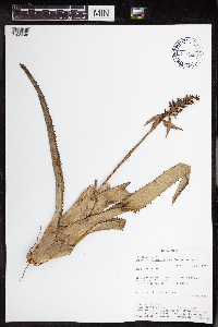 Aechmea angustifolia Poepp. & Endl. 438202[1345048]Rueda, Ricardo 18201994-07-06 Nicaragua, Rio San Juan, Spanish Creek, spout of Agua Negra, branch of Rio Indio., 0 - 100m |
MIN:Plants | 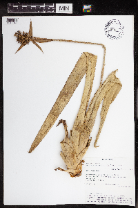 Aechmea angustifolia Poepp. & Endl. 438201[1345049]Rueda, Ricardo 25531995-01-05 Nicaragua, Rio San Juan, Caño Negro and Caño Pescado. Greytown, 11.90864 -83.893528 |
MIN:Plants | 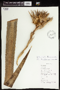 Aechmea magdalenae (André) André ex Baker 540789[1345050]Salick 7867 Nicaragua, Rio San Juan. "La Lupe" near Rio Santa Cruz., 11.017941 -84.421127 |
MIN:Plants | 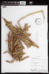 Aechmea pubescens Baker 459561[1345051]Rueda, Ricardo 36331994-02-27 Nicaragua, Zelaya, Rio Punta Gorda. South of San José., 11.5167 -83.7833 |
MIN:Plants |  Billbergia pallidiflora Liebm. 459555[1345056]Stevens, Warren Douglas 3275 Nicaragua, Nueva Segovia, 5.2 km N of San Fernando, valley of Río San Fernando (800 m), NE to Portillo Los Coyoles (1083 m), SW up narrow quebrada to Cerro El Peñascal (1125 m)., 13.791246 -86.292158 |
MIN:Plants |  488862[1345057]Stevens, Warren Douglas 44371977-10-06 Nicaragua, Masaya, Parque Nacional Volcán Masaya, near W shore of Laguna de Masaya, ca. 7.1 km S of Hwy 4., 11.969618 -86.114508, 140 - 200m |
MIN:Plants |  515309[1345058]Stevens, Warren Douglas 4296 Nicaragua, Masaya, Parque Nacional Volcán Masaya, small peninsula on W shore of Laguna de Masaya, ca. 3.9 km S of Hwy 4., 11.969618 -86.114508, 135 - 145m |
MIN:Plants |  Catopsis hahnii Baker 438588[1345061]Nee, Micheal 284481983-09-23 Nicaragua, Chontales, 4 km NNW of Cuapa, ridgetops and summits of Cerro Oluma., 12.304148 -85.372854, 700 - 775m |
MIN:Plants |  Catopsis hahnii Baker 493865[1345062]Grijalva, A. 6821979-11-19 Nicaragua, Cerro Quiabú, situado a unos 8 kilometers al norte este de la ciudad de Estelí [[Near Quiabú, located about 8 kilometers north east of the city of Estelí]], 13.116667 -86.433333, 1500 - 1600m |
MIN:Plants |  Catopsis montana L.B.Sm. 438048[1345066]Stevens, Warren Douglas 203811981-05-24 Nicaragua, Jinotega, Along Hwy 3 ca 1 km NW of La Fundadora entrance, unnamed peak ca 500 m W of Hwy., 13.06639 -85.918443, 1450 - 1520m |
MIN:Plants |  Catopsis nitida Griseb. 526488[1345069]Stevens, Warren Douglas 215961982-06-23 Nicaragua, Jinotega, Laguna Miraflor, 13.050768 -86.302235, 1250 - 1300m |
MIN:Plants |  Catopsis nitida Griseb. 438049[1345070]Stevens, Warren Douglas s.n.1979-10-31 Nicaragua, Jinotega, Along road from Hwy 3 through La Fundadora, between La Salvadora and La Palestina., 13.06639 -85.918443, 1100 - 1150m |
MIN:Plants |  Catopsis nitida Griseb. 540895[1345071]Stevens, Warren Douglas 152451979-11-25 Nicaragua, Departamento Jinotega: North slope of Volcán Yalí, 13.25 -86.166667, 1200 - 1400m |
MIN:Plants |  Guzmania angustifolia Wittm. 438606[1345074]Robleto, Walter 8491984-06-15 Nicaragua, Rivas, Isla Ometepe, Volcán Maderas, property of "La Argentina"., 11.44554 -85.515765, 700 - 900m |
MIN:Plants |  Guzmania monostachya Rusby 438050[1345078]Stevens, Warren Douglas 11,9061979-01-25 Nicaragua, Matagalpa, Ridge along road between La Danta and La Luna, E of Esquiplas., 11.764729 -85.889604, 960 - 1000m |
MIN:Plants |  Guzmania nicaraguensis Mez & Baker 540896[1345079]Stevens, Warren Douglas 204291981-05-24 Nicaragua, Jinotega, Along Hwy 3 ca 1 km NW of La Fundadora entrance, unnamed peak ca 500 m W of Hwy., 13.06639 -85.918443, 1450 - 1520m |
MIN:Plants |  459565[1345086]Moreno, Pedro P. 199331983-02-02 Nicaragua, Esteli, "Portal de Belen" Kukamonga to the N of Esteli., 13.091853 -86.353841, 800 - 840m |
MIN:Plants |  540919[1345093]Stevens, Warren Douglas 11,8661979-01-25 Nicaragua, Matagalpa, Ridge along road between La Danta and La Luna, E of Esquiplas., 11.764729 -85.889604, 960 - 1000m |
MIN:Plants |  Catopsis hahnii Baker 962418[1345063]Moreno, P. 13381980-07-24 Nicaragua, Departamento de Estelí: cerro Quiabú, al NO de Estelí [[Department Estelí :near Quiabú, NW of Estelí]], 13.116667 -86.433333, 1600m |
MIN:Plants |  Catopsis juncifolia Mez & Wercklé 962417[1345064]Soza, D. 1161984-07-20 Nicaragua, Matagalpa, Cerro El Apante Grande, ca 2 km to the S of Matagalpa., 12.925592 -85.917474, 1000 - 1100m |
MIN:Plants |  Catopsis montana L.B.Sm. 962416[1345065]Moreno, P.P. 34341980-10-07 Nicaragua, Matagalpa, Highway to Jinotega, Fuente Pura at 11 km de Matagalpa highway to Jinotega., 13.026298 -85.924505, 1400 - 1450m |
MIN:Plants |  962415[1345067]Pipoly, John, J. 42761979-03-10 Nicaragua, Zelaya, Cerro Waylawás summit, central range., 13.655681 -84.817744, 200 - 225m |
MIN:Plants |  962414[1345068]Nee, Micheal 278271983-09-06 Nicaragua, Zelaya, 0-1 Km. N of San Martin., 12.17609 -86.03771, 120m |
MIN:Plants |  Catopsis nitida Griseb. 962413[1345094]Araquistain, M. 9031980-01-20 Nicaragua, Departamento de Jinotega: Carretera entre Matagalpa y Jinotega, aproximadamente en el kilometer 157.8, a la orilla de la misma carretera. [[Jinotega Department: Highway between Matagalpa and Jinotega, approximately at kilometer 157.8, on the edge of the same highway.]], 13.023373 -85.921749, 1000m |
MIN:Plants |  Catopsis nitida Griseb. 962412[1345072]Moreno, P.P. 34321980-10-07 Nicaragua, Matagalpa, 1400 - 1450m |
MIN:Plants |  Catopsis nitida Griseb. 962411[1345095]Araquistain, M. 9031980-01-20 Nicaragua, Jinotega, Road between Matagalpa and Jinotega, Km 157.8, on the edge of the same road., 13.091712 -86.001769, 1000m |
MIN:Plants |  962410[1345077]Rueda, Ricardo 25161995-01-04 Nicaragua, Rio San Juan, Rio Indio, entry to Greytown and the division of Pimienta and the Indio. Greytown, 10.94684 -83.734665 |
MIN:Plants |  962409[1345096]Rueda, Ricardo 19261994-07-10 Nicaragua, Rio San Juan. A lo logo del Rio San Juan entre El Tambor y Remolinos, incluyendo el caño de San Francisco. [[Rio San Juan. Along the Rio San Juan between El Tambor and Remolinos, including the San Francisco pipe.]], 10.75 -84.016667, 50 - 200m |
MIN:Plants |  Guzmania monostachya Rusby 962419[1345097]Grijalva, A. 19591982-11-24 Nicaragua, Granada, Isla Zapatera, coast E of Hacienda El Cerro., 11.740884 -85.831655, 400 - 500m |
MIN:Plants |  Guzmania monostachya Rusby 962420[1345098]Rueda, Ricardo 20241994-07-15 Nicaragua, Rio San Juan, Along the River Sábalos, starting off at the town Boca de Sábalos., 11.05 -84.466667 |
MIN:Plants |  Guzmania monostachya Rusby 962421[1345099]Stevens, Warren Douglas 34971977-08-25 Nicaragua, Managua, 5.4 km NE of E1 Crucero, ridge of Sierra de Managua near Hda. Palmíra., 12.14699 -86.207132, 800 - 900m |
MIN:Plants |  Guzmania monostachya Rusby 962422[1345100]Moreno, P.P. 4123A1980-11-28 Nicaragua, Departamento de Granada: Volcán Mombacho, subiendo por la finca Las Delicias, 1 1/2 kilometers de la Hda. [[Granada Department: Mombacho Volcano, going up the Las Delicias farm, 1 1/2 kilometers from Hda]], 11.85 -85.966667, 800m |
MIN:Plants | 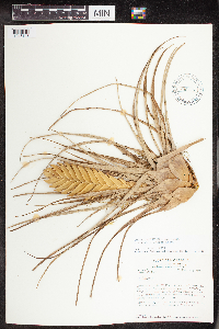 436865[1345143]Stevens, Warren Douglas 123801979-02-21 Nicaragua, Zelaya, Along road from Constancia to Laguna Siempreviva., 13.866667 -84.516667, 290 - 360m |
MIN:Plants | 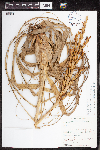 438562[1345144;1343905]Stevens, Warren Douglas 10,0091978-08-16 Nicaragua, Managua, Along new road from Hwy. 1 (N of San Jacinto entrance) to San Fransisco del Carnicero, ca 4.8 km W of Hwy 1;, 12.339997 -86.020686, 100m |
MIN:Plants | 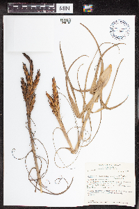 Tillandsia balbisiana Schult. & Schult. f. 459618[1345145]Stevens, Warren Douglas 44381977-11-06 Nicaragua, Department de Masaya: Parque Nacional Volcán Masaya, near west shore of Laguna de Masaya, ca. 7.1 kilometers south of Highway 4 [[Masaya Department: Masaya Volcano National Park, near west shore of Laguna de Masaya, ca. 7.1 kilometers south of Highway 4]], 11.985222 -86.160729, 140 - 200m |
MIN:Plants | 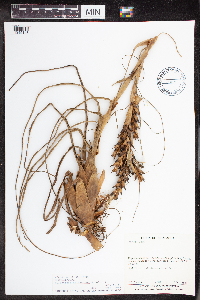 Tillandsia balbisiana Schult. & Schult. f. 493876[1345146]Sandino, J.C. 17821981-12-17 Nicaragua, Rio San Juan, W de San Carlos, 11.134363 -84.833771, 30 - 35m |
MIN:Plants |  Tillandsia bulbosa Hook. 438618[1345147]Rueda, Ricardo 44651996-07-24 Nicaragua, Rio San Juan, Indio-Maiz Reserve. Gigante Hill., 380 - 412m |
MIN:Plants |  438808[1345148]Araquistain, M. 1731979-08-29 Nicaragua, Departamento de Matagalpa. Kilometer 139 a un lado de la carretera. [[Matagalpa Department. Kilometer 139 on the side of the road.]], 12.911313 -85.849315, 1600m |
MIN:Plants |  438620[1345149]Grijalva, A. 205 Nicaragua, Jinotega, Property La Palestina. Situated 10 km to the east of the city of Jinotega., 13.071014 -85.897827, 1200 - 1300m |
MIN:Plants |  493119[1345150]Stevens, Warren Douglas 152421979-10-25 Nicaragua, Jinotega, N slope of Volcán Yalí; Coffee plantations on lower slopes, upper slopes with tall closed forest., 13.271317 -86.126325, 1200 - 1400m |
MIN:Plants | 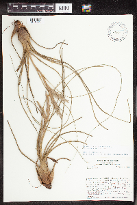 493150[1345153]Stevens, Warren Douglas 11,5761979-01-16 Nicaragua, Jinotega, Macizos de Peñas Blancas, top and N slope of steep ridge SW of finca of Manuel Estrada (El Cielo), S of Río Gusaneras., 13.287235 -85.672431, 1200 - 1330m |
MIN:Plants | 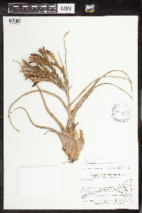 Tillandsia caput-medusae E.Morren 488103[1345154]Griajalva, A. 7451979-11-06 Nicaragua, Granada, Puerto de Asese, situado a unos 5 km SE de la ciudad de Granada e isletas de Granada [Puerto de Asese, located about 5 km SE from the city of Granada and islets of Granada], 11.867168 -85.852542, 40m |
MIN:Plants | 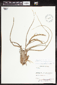 Tillandsia caput-medusae E.Morren 488105[1345155]Moreno, P. 89141981-05-30 Nicaragua, Masaya, Laguna de Masaya., 11.969618 -86.114508, 120 - 160m |
MIN:Plants | 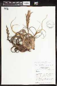 Tillandsia caput-medusae E.Morren 515326[1345156]Stevens, Warren Douglas 11,0551978-12-11 Nicaragua, Masaya, Parque Nacional Volcán Masaya, W shore of Laguna de Masaya, ca. 3.9 km S of Hwy. 4; ca., 11.969618 -86.114508, 140m |
MIN:Plants |  Tillandsia deflexa L.B.Sm. 493788[1345157]Araquistain, M. 6861979-10-19 Nicaragua, Cerro Quiabú, situado a unos 8 kilometers al North East de la ciudad de Estelí, bosque enano, nublado. [[Near Quiabú, located about 8 kilometers North East of the city of Estelí, dwarf forest, cloudy.]], 13.116667 -86.433333, 1500 - 1600m |
MIN:Plants |  Tillandsia fasciculata Swartz 488411[1345159]Pipoly, John, J. 42221979-03-09 Nicaragua, Zelaya, Cerro Waylawás, E side of central range., 13.655681 -84.817744, 100 - 200m |
MIN:Plants |  Tillandsia fasciculata Swartz 488412[1345160]Grijalva, A. 14111982-10-09 Nicaragua, Matagalpa, Chapel of Es-Equipulas, situated 20 km NE of El Tuma (between Río Wasaka and Río Bulbul); ca 13., 13.189679 -85.613782, 500m |
MIN:Plants |  Tillandsia fasciculata Swartz 540899[1345161]Stevens, Warren Douglas 152401979-10-25 Nicaragua, N slope of Volcán Yalí; Coffee plantations on lower slopes, upper slopes with tall closed forest., 13.269646 -86.124608, 1200 - 1400m |
MIN:Plants |  Tillandsia fasciculata Swartz 436864[1345162]Araquistain, M. 146161979-10-03 Nicaragua, Departamento Boaco: upper south west slope of Cerro Mombachito, south of road between Boaco and Camoapa, 12.4 -85.55, 900 - 1000m |
MIN:Plants |  Tillandsia fasciculata Swartz 515308[1345163]Stevens, Warren Douglas 12,0431979-02-12 Nicaragua, Matagalpa, Lower W slope of Cerro Musun, Quebrada El Jobo, a tributary of Río Paiwas., 12.985186 -85.242346, 300m |
MIN:Plants |  Tillandsia festucoides Brongn. ex Mez 515294[1345164]Stevens, Warren Douglas 12,0421979-02-12 Nicaragua, Matagalpa, Lower W slope of Cerro Musun, Quebrada El Jobo, a tributary of Río Paiwas., 12.985186 -85.242346, 300m |
MIN:Plants |  Tillandsia guatemalensis L.B.Sm. 488115[1345165]Araquistain, M. 21571980-04-16 Nicaragua, Departamento de Madriz; Cerro Volcán de Somoto (Tepesomoto) cerca de la cima. [[Madriz Department; Cerro Volcán de Somoto (Tepesomoto) near the top.]], 13.416667 -86.566667, 1500 - 1600m |
MIN:Plants | 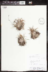 Tillandsia ionantha Planch. 488117[1345168]Rueda, Ricardo 12461993-10-25 Nicaragua, Carretera entre Las Peñinas y Poneloya. [[Highway between Las Peñinas and Poneloya.]], 12.383333 -87.016667 |
MIN:Plants | 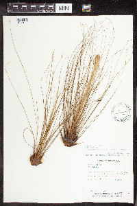 Tillandsia juncea Poir. 488414[1345169]Moreno, P. 56881980-12-28 Nicaragua, Nueva Segovia, El Jícaro, road to the Hda. of Tranquera., 13.722864 -86.132275, 650 - 680m |
MIN:Plants | 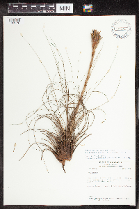 Tillandsia juncea Poir. 515291[1345170]Stevens, Warren Douglas 160661979-11-22 Nicaragua, Madriz, Cerro Quisuca, summit and upper slopes., 13.511639 -86.529492, 1100 - 1250m |
MIN:Plants | 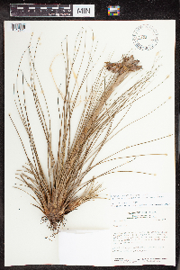 Tillandsia juncea Poir. 515296[1345171]Stevens, Warren Douglas 144761979-10-01 Nicaragua, Esteli, Departamento ESTELI: Salto de Estanzuela, Rio Estanzuela ca 6 km S of Esteli, 13.016667 -86.333333, 920 - 1020m |
MIN:Plants | 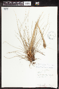 Tillandsia juncea Poir. 515292[1345172]Vincelli, Paul C. 7981978-08-12 Nicaragua, Madriz, Eastern slope of Cerro Mogote de la Caguasea., 13.902095 -86.162593, 1350 - 1400m |
MIN:Plants | 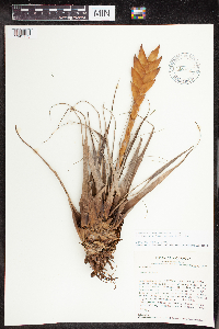 Tillandsia lampropoda L.B.Sm. 515305[1345173]Stevens, Warren Douglas 11,5471979-01-16 Nicaragua, Jinotega, Macizos de Peñas Blancas, top and N slope of steep ridge SW of finca of Manuel Estrada (El Cielo), S of Río Gusaneras; ca., 13.287235 -85.672431, 1200 - 1330m |
Google Map
Google Maps is a web mapping service provided by Google that features a map that users can pan (by dragging the mouse) and zoom (by using the mouse wheel). Collection points are displayed as colored markers that when clicked on, displays the full information for that collection. When multiple species are queried (separated by semi-colons), different colored markers denote each individual species.