University of Minnesota
http://www.umn.edu/
612-625-5000
http://www.umn.edu/
612-625-5000
Minnesota Biodiversity Atlas
Bell Museum
Dataset: MIN-Plants
Search Criteria: Peru; excluding cultivated/captive occurrences
Bell Museum plants | |
 MIN:Plants |  Passiflora sanquinolenta Masters & Linden 896999[1290162]Diaz, Camilo 74281995-01-17 Peru, Tumbes, Zarumilla Province, Matapalo. El Caucho-Camp Verde, parcela de evaluacion permanente "E"., 700m |
MIN:Plants |  429695[1299167]Croat, Thomas 190561972-08-11 Peru, Loreto, Ca. 6 km up Rio Itaya from Iquitos. |
MIN:Plants | Heliconia hirsuta L. f. 432237[]Schunke V., Jose 105261978-08-26 Peru, Huanuco, Prov: Leoncio Prado. Distrito: Rupa Rupa...Al oeste de Tingo Maria., 700 - 800m |
MIN:Plants | Rinorea viridifolia Rusby 633652[]Croat, Thomas 202621972-09-16 Peru, Loreto, Altura Tuta Pishco on Rio Napo |
MIN:Plants | Passiflora auriculata Kunth 515096[]Jaramillo, N.; et al. 13391996-03-11 Peru, Amazonas, Bagua Province, Bagua Province. YamayakatBosque de Rivera;;;;, -4.9166667 -78.3166667, 320m |
MIN:Plants | Aniba heterotepala van der Werff 476000[]Croat, Thomas 190101972-08-09 Peru, Loreto, at Puerto Almendra, SW of Iquitos on Rio Nanay. |
MIN:Plants | Pourouma minor Benoist 487975[]Weiblen, G.D. GW14622001-10-12 Peru, Cocha Cashu, Manu National Park, -7.983333 -74.683333, 153m |
MIN:Plants | Castilla ulei Warb. 431608[]Weiblen, G.D. GW14562001-10-12 Peru, Cocha Cashu, Manu National Park, -7.983333 -74.683333, 153m |
MIN:Plants | Morus insignis Bur. 431620[]Weiblen, G.D. GW14502001-10-08 Peru, Cloud Forest Lodge, Manu National Park, -12.25 -70.9, 295m |
MIN:Plants | Pourouma minor Benoist 487974[]Weiblen, G.D. GW14742001-10-15 Peru, Cocha Cashu, Manu National Park, -7.983333 -74.683333, 153m |
MIN:Plants | Ficus obtusifolia Kunth 493689[]Weiblen, G.D. GW14942001-10-20 Peru, Cocha Cashu, Manu National Park, -7.983333 -74.683333, 153m |
MIN:Plants | Ficus americana subsp. guianensis (Desv.) C.C. Berg 493679[]Weiblen, G.D. GW14822001-10-16 Peru, Cocha Cashu, Manu National Park, -7.983333 -74.683333, 153m |
MIN:Plants | Ficus americana subsp. guianensis (Desv.) C.C. Berg 488329[]Weiblen, G.D. GW14932001-10-15 Peru, Cocha Cashu, Manu National Park, -7.983333 -74.683333, 153m |
MIN:Plants | Poulsenia armata (Miq.) Standl. 431426[]Weiblen, G.D. GW14872001-10-16 Peru, Cocha Cashu, Manu National Park, -7.983333 -74.683333, 153m |
MIN:Plants | Clarisia biflora Ruiz & PavÛn 431607[]Weiblen, G.D. GW14602001-10-12 Peru, Cocha Cashu, Manu National Park, -7.983333 -74.683333, 153m |
MIN:Plants | Clarisia biflora Ruiz & PavÛn 431624[]Weiblen, G.D. GW14652001-10-12 Peru, Cocha Cashu, Manu National Park, -7.983333 -74.683333, 153m |
MIN:Plants | Sorocea briquetii Macbride 431435[]Weiblen, G.D. GW14572001-10-12 Peru, Cocha Cashu, Manu National Park, -7.983333 -74.683333, 153m |
MIN:Plants | Ficus caballina Standley 488327[]Weiblen, G.D. GW14882001-10-15 Peru, Cocha Cashu, Manu National Park, -7.983333 -74.683333, 153m |
MIN:Plants | Maquira calophylla (Poepp. & Endl.) C.C. Berg 431621[]Weiblen, G.D. GW13992001-10-21 Peru, Cocha Cashu, Manu National Park, -7.983333 -74.683333, 153m |
MIN:Plants | Ficus casapiensis (Miq.) Miq. 493495[]Weiblen, G.D. GW14802001-10-16 Peru, Cocha Cashu, Manu National Park, -7.983333 -74.683333, 153m |
MIN:Plants | Ficus casapiensis (Miq.) Miq. 431405[]Weiblen, G.D. GW14832001-10-16 Peru, Cocha Cashu, Manu National Park, -7.983333 -74.683333, 153m |
MIN:Plants | Ficus coerulescens (Rubsy) Rossberg 488301[]Weiblen, G.D. GW14912001-10-15 Peru, Cocha Cashu, Manu National Park, -7.983333 -74.683333, 153m |
MIN:Plants | Batocarpus costaricensis Standley & L.O.Williams 431418[]Weiblen, G.D. GW14632001-10-12 Peru, Cocha Cashu, Manu National Park, -7.983333 -74.683333, 153m |
MIN:Plants | Ficus eximia Scott 431407[]Weiblen, G.D. GW14512001-10-08 Peru, Cloud Forest Lodge, Manu National Park, -12.25 -70.9, 295m |
MIN:Plants | Ficus gomelleira Kunth & BouchÈ 432556[]Weiblen, G.D. GW14712001-10-15 Peru, Cocha Cashu, Manu National Park, -7.983333 -74.683333, 153m |
MIN:Plants | Brosimum guianense (Aubl.) Huber 431422[]Weiblen, G.D. GW14762001-10-15 Peru, Cocha Cashu, Manu National Park, -7.983333 -74.683333, 153m |
MIN:Plants | Brosimum guianense (Aubl.) Huber 431419[]Weiblen, G.D. GW14952001-10-21 Peru, Cocha Cashu, Manu National Park, -7.983333 -74.683333, 153m |
MIN:Plants | Perebea humilis C. C. Berg 431459[]Weiblen, G.D. GW14682001-10-12 Peru, Cocha Cashu, Manu National Park, -7.983333 -74.683333, 153m |
MIN:Plants | 493598[]Weiblen, G.D. GW14552001-10-12 Peru, Cocha Cashu, Manu National Park, -7.983333 -74.683333, 153m |
MIN:Plants |  Naucleopsis krukovii (Standley) C. C. Berg 431615[]Weiblen, G.D. GW14842001-10-16 Peru, Cocha Cashu, Manu National Park, -7.983333 -74.683333, 153m |
MIN:Plants |  Naucleopsis krukovii (Standley) C. C. Berg 431614[]Weiblen, G.D. GW14982001-10-23 Peru, Cocha Cashu, Manu National Park, -7.983333 -74.683333, 153m |
MIN:Plants | Brosimum lactescens (S. Moore) C.C. Berg 431424[]Weiblen, G.D. GW14582001-10-12 Peru, Cocha Cashu, Manu National Park, -7.983333 -74.683333, 153m |
MIN:Plants | Brosimum lactescens (S. Moore) C.C. Berg 431425[]Weiblen, G.D. GW14672001-10-12 Peru, Cocha Cashu, Manu National Park, -7.983333 -74.683333, 153m |
MIN:Plants | Brosimum lactescens (S. Moore) C.C. Berg 431400[]Weiblen, G.D. GW14732001-10-15 Peru, Cocha Cashu, Manu National Park, -7.983333 -74.683333, 153m |
MIN:Plants | Pseudolmedia laevigata Trécul 431427[]Weiblen, G.D. GW14612001-10-12 Peru, Cocha Cashu, Manu National Park, -7.983333 -74.683333, 153m |
MIN:Plants | Pseudolmedia laevis (Ruiz & Pav.) Macbride 431432[]Weiblen, G.D. GW14592001-10-12 Peru, Cocha Cashu, Manu National Park, -7.983333 -74.683333, 153m |
MIN:Plants | Perebea longepedunculata C. C. Berg 431460[]Weiblen, G.D. GW14772001-10-15 Peru, Cocha Cashu, Manu National Park, -7.983333 -74.683333, 153m |
MIN:Plants | Pseudolmedia macrophylla Trecul 431433[]Weiblen, G.D. GW14722001-10-15 Peru, Cocha Cashu, Manu National Park, -7.983333 -74.683333, 153m |
MIN:Plants | Ficus maxima P. Miller 493710[]Weiblen, G.D. GW14852001-10-16 Peru, Cocha Cashu, Manu National Park, -7.983333 -74.683333, 153m |
MIN:Plants | Ficus pertusa L.f. 488319[]Weiblen, G.D. GW14892001-10-15 Peru, Cocha Cashu, Manu National Park, -7.983333 -74.683333, 153m |
MIN:Plants | Ficus sphenophylla Standley 493274[]Weiblen, G.D. GW14812001-10-16 Peru, Cocha Cashu, Manu National Park, -7.983333 -74.683333, 153m |
MIN:Plants | Perebea tessmanii Mildbr. 431609[]Weiblen, G.D. GW14972001-10-23 Peru, Cocha Cashu, Manu National Park, -7.983333 -74.683333, 153m |
MIN:Plants | Maclura tinctoria NULL 431622[]Weiblen, G.D. GW14962001-10-21 Peru, Cocha Cashu, Manu National Park, -7.983333 -74.683333, 153m |
MIN:Plants | Helicostylis tomentosa (Poep. & Endl.) Rusby 431626[]Weiblen, G.D. GW14752001-10-15 Peru, Cocha Cashu, Manu National Park, -7.983333 -74.683333, 153m |
MIN:Plants | Ficus trigona L. f. 493598[]Weiblen, G.D. GW14532001-10-10 Peru, Cocha Cashu, Manu National Park, -12.25 -70.9, 295m |
MIN:Plants | Coussapoa villosa Poeppig & Endl. 487971[]Weiblen, G.D. GW14862001-10-16 Peru, Cocha Cashu, Manu National Park, -7.983333 -74.683333, 153m |
MIN:Plants | Coussapoa villosa Poeppig & Endl. 487970[]Weiblen, G.D. GW14922001-10-15 Peru, Cocha Cashu, Manu National Park, -7.983333 -74.683333, 153m |
MIN:Plants | Coussapoa villosa Poeppig & Endl. 487970[]Weiblen, G.D. GW14522001-10-08 Peru, Cloud Forest Lodge, Manu National Park, -12.25 -70.9, 295m |
MIN:Plants | Ficus ypsilophlebia Dugand 432563[]Weiblen, G.D. GW14702001-10-12 Peru, Cocha Cashu, Manu National Park, -7.983333 -74.683333, 153m |
MIN:Plants | 488158[]Weiblen, G.D. GW14542001-10-12 Peru, Cocha Cashu, Manu National Park, -12.25 -70.9, 295m |
MIN:Plants | 431416[]Weiblen, G.D. GW14692001-10-12 Peru, Cocha Cashu, Manu National Park, -7.983333 -74.683333, 153m |
MIN:Plants | Castilla NULL 431610[]Weiblen, G.D. GW14992001-10-23 Peru, Cocha Cashu, Manu National Park, -7.983333 -74.683333, 153m |
MIN:Plants | 947597[]Weiblen, G.D. GW14782001-10-15 Peru, Cocha Cashu, Manu National Park, -7.983333 -74.683333 |
MIN:Plants | Clarisia racemosa Ruiz. & Pav. 431617[]Weiblen, G.D. GW14642001-10-12 Peru, Cocha Cashu, Manu National Park, -7.983333 -74.683333, 153m |
MIN:Plants | Cecropia engleriana Snethl. 926815[]Barriga, Paola 2009-1532009-02-15 Peru, Madre de Dios. Los Amigos Biological Station. Close to soccer field in the station. Disturbed area inside Los Amigos Station. Close to the soccer field., 250m |
MIN:Plants | Cecropia membranacea Trecul 926819[]Barriga, Paola 2009-1592009-02-16 Peru, Madre de Dios. Collected at the port of Los Amigos Station. Close to the sign of the station., 250m |
MIN:Plants | Cecropia tacuna C.C. Berg & P. Franco 927202[]Bevington, J. Bevington692010-06-05 Peru, Peru cloud forest. Young leaf., -13.1006 -71.5185, 1982m |
MIN:Plants | Cecropia tacuna C.C. Berg & P. Franco 927203[]Bevington, J. Bevington642010-06-05 Peru, Cloud forest. Young leaf., -13.1203 -71.5708, 2165m |
MIN:Plants | Cecropia ficifolia Snethl. 927204[]Barriga, Paola 2009-1682009-02-17 Peru, Madre de Dios, Los Amigos Biological Station |
MIN:Plants | Cecropia membranacea Trecul 927206[]Barriga, Paola 2009-1672009-02-18 Peru, Madre de Dios, Los Amigos Biological Station |
MIN:Plants | Cecropia membranacea Trecul 927207[]Barriga, Paola 2009-1562009-02-16 Peru, Madre de Dios, Los Amigos Biological Station |
MIN:Plants | 927208[]Barriga, Paola 2009-0592009-00-00 Peru, Madre de Dios, Los Amigos Biological Station |
MIN:Plants | Cecropia distachya Huber 927209[]Barriga, Paola 2009-5982009-02-28 Peru, Madre de Dios, Los Amigos Biological Station; airport; 100m from techo on the side of the airstrip with a trail, 20m off trail, 250m |
MIN:Plants | 927210[]Barriga, Paola 2009-1542009-02-14 Peru, Madre de Dios, Los Amigos Biological Station; airport; 100m from techo on the side of the airstrip with a trail, 20m off trail |
MIN:Plants | 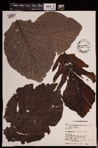 Cecropia polystachya Trécul 951328[1290199]Bevington, J. 84A2013-06-09 Peru |
MIN:Plants | 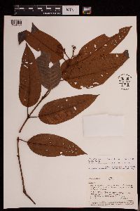 Vismia baccifera (L.) Triana & Planch. 953247[1291769]Vazquez, R. 253 Peru, Loreto |
MIN:Plants | 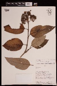 Vismia tomentosa Ruiz & Pav. 953246[1291770]Smith, David 2804 Peru, Oxapampa |
MIN:Plants | 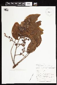 Sterculia apetala var. elata (Ducke) E.L. Taylor ex Brako & Zarucchi 520697[1293533;1293534]Berlin, Brent 35351979-08-06 Peru, Amazonas |
MIN:Plants |  Carex collumanthus (Steyerm.) G.A. Wheeler 953602[1292835]Ruthsatz 10132 Peru, Arequipa |
MIN:Plants |  Desmoncus polyacanthos C. Mart. 956110[1295600;1295601]Vasquez, R. 13559 Peru, Loreto |
MIN:Plants |  Erythroxylum fimbriatum Peyr. 926042[1299656] Peru |
MIN:Plants |  Erythroxylum glaucum O.E.Schulz 641875[1299657] Peru |
MIN:Plants |  Erythroxylum mamacoca Mart. 633618[1299661] Peru |
MIN:Plants |  Erythroxylum mucronatum Benth. 949079[1299662] Peru |
MIN:Plants |  Erythroxylum patens Ruiz ex O.E.Schulz 492170[1299664] Peru |
MIN:Plants |  Marcgravia longifolia J.F. Macbr. 438682[1299679]Ruiz, Juan 0032004-11-23 Peru, Road to Pto. Almendras, about 1-1.5 km past golf course, on left side of roaod [road] |
MIN:Plants | 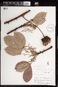 Hevea guianensis Aubl. 911680[1299702]Victor Huaschikat 12141979-11-09 Peru, Rio Santiago, monte virgen, 2 km atras de comunidad Caterpiza, banda este, en trocha, -3.908575 -77.708755, 180m |
MIN:Plants | chaubardia klugii (C.Schweinf.) Garay 435972[1304492]Vasquez. R. Peru, Maynas, Las Amazonas, Detailed locality information protected. This is typically done to protect rare or threatened species localities. |
MIN:Plants |  Adiantum glaucophyllum Hook. 50701[1303444]Murray, Alex s.n. Peru |
MIN:Plants |  50690[1303445]Murray, Alex s.n. Peru |
MIN:Plants |  Adiantum poeppigianum C.Presl 478613[1303449]Timana, Martin 20811991-08-26 Peru, Tambopata, 200m |
MIN:Plants | 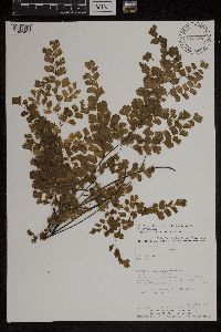 Adiantum raddianum C. Presl 919628[1303451]Diaz, C. 48481992-07-13 Peru, Zarumilla, -3.841389 -80.259167, 720m |
MIN:Plants | 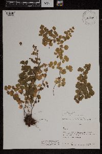 Adiantum subvolubile Mett.; Kuhn 920188[1303453]Gentry, Al 164951976-07-04 Peru, South of Lima near Pachacamac, -12.225589 -76.857551, 120 - 410m |
MIN:Plants | 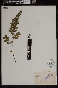 Adiantum decorum T.Moore 50832[1303457]Murray, Alex s.n. Peru |
MIN:Plants | 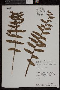 Asplenium alatum Humb. & Bonpl. ex Willd. 949166[1307315]Croat, Thomas B. 581661984-04-12 Peru, San Martin, Along road between Moyobamba and Chachapoyas, in vicinity of Km marker 415, 13.5 km W of Naranjos, -5.633333 -77.416667, 700m |
MIN:Plants |  461382[1307316]Timana, Martin 27051991-10-19 Peru, Tambopata, Las Piedras, Madre de Dios: Tambopata Province Las Piedras. Cusco Amazónico. Inventrio Permanente., -12.483333 -69.05, 200m |
MIN:Plants |  427613[1307317]Timana, M. 22981991-09-21 Peru, Tambopata, Las Piedras, Madre de Dios: Tambopata Province Las Piedras. Cusco Amazonico. Inventario Permanente. Plantas colectadas en la zona 2., -12.483333 -69.05, 200m |
MIN:Plants |  Asplenium cirrhatum Rich. 937399[1307318]Vasquez, R. 170611991-07-06 Peru, Maynas, Loreto, Iquitos, Allpahuayo-IIAP. Bosque primario, inundable solo hay grandes lluvias (Quebrada Shimbaico), muestreo de 1000 m cuadrada en subparcelas de 50 x 2 m, -4.166667 -73.5, 150 - 180m |
MIN:Plants |  Asplenium cirrhatum Rich. 485123[1307319]Vasquez, R. 165211991-05-25 Peru, Maynas, Loreto, Iquitos. Allpahuayo. Estación Experimental del Instituto de Investigaciones de la Amazonia Peruana (IIAP); (Quebrada Brashico), -4.166667 -73.5, 150 - 180m |
MIN:Plants |  Asplenium pearcei Baker 427609[1307328]Vasquez, R. 173751991-07-11 Peru, Maynas, Loreto, Iquitos, Allpahuayo-IIAP., -4.166667 -73.5, 150 - 180m |
MIN:Plants |  Asplenium pearcei Baker 478608[1307329]Timana, M. 21001991-08-28 Peru, Tambopata, Madre de Dios, Las Piedras. Cusco Amazónico, Inventario Permanente., -12.483333 -69.05, 200m |
MIN:Plants |  485095[1307332]Vasquez, R. 163161991-05-22 Peru, Maynas, Loreto, Iquitos, Allpahuayo. Estación Experimental del Instituto de Investigaciones de la Amazonía Peruana (IIAP), -4.166667 -73.5, 150 - 180m |
MIN:Plants |  485089[1307333]Vasquez, R. 162301991-05-21 Peru, Maynas, Loreto, Iquitos, Allpahuayo. Estación Experimental del Instituto de Investigaciones de la Amazonía Peruana (IIAP)., -4.166667 -73.5, 150 - 180m |
MIN:Plants |  Asplenium stubelianum Hieron. 427554[1307336]Vasquez, R. 166361991-05-27 Peru, Maynas, Loreto, Iquitos, Allpahuayo. Estación Experimental del Instituto de Investigaciones de la Amazonia Peruana (IIAP)., -4.166667 -73.5, 150 - 180m |
MIN:Plants |  Asplenium stubelianum Hieron. 427555[1307337]Vasquez, R. 166961991-05-30 Peru, Maynas, Loreto, Iquitos, Allpahuayo. Estacion Experimental del Instituto de Investigaciones de la Amazonia Peruana (IIAP)., -4.166667 -73.5, 150 - 180m |
MIN:Plants |  Asplenium zamiifolium Willd. 925564[1307339]Smith, D.N. 63561984-03-00 Peru, Oxapampa, Pasco, Trail between Yanahuanca and Chumalli along Rio Pozuzo, -11.77974 -75.05808, 820 - 1100m |
MIN:Plants |  453116[1307795]Vasquez, R. 167341991-06-16 Peru, Maynas |
MIN:Plants |  433740[1309509]Cook, O.F. 2411915-04-20 Peru, Near Calca |
MIN:Plants | 503656[1310356]Vasquez, R. Peru, Maynas, Detailed locality information protected. This is typically done to protect rare or threatened species localities. |
MIN:Plants | Epidendrum funkii Rchb.f. 899987[1310360]Croat, Thomas B. Peru, Detailed locality information protected. This is typically done to protect rare or threatened species localities. |
Google Map
Google Maps is a web mapping service provided by Google that features a map that users can pan (by dragging the mouse) and zoom (by using the mouse wheel). Collection points are displayed as colored markers that when clicked on, displays the full information for that collection. When multiple species are queried (separated by semi-colons), different colored markers denote each individual species.