University of Minnesota
http://www.umn.edu/
612-625-5000
http://www.umn.edu/
612-625-5000
Minnesota Biodiversity Atlas
Bell Museum
Dataset: MIN-Plants
Search Criteria: Slovakia; excluding cultivated/captive occurrences
1
Page 1, records 1-15 of 15
Bell Museum plants | |
 MIN:Plants | Corallorhiza trifida Ch̢telain 552635[1306557]Domin, K. Slovakia, Detailed locality information protected. This is typically done to protect rare or threatened species localities. |
MIN:Plants | 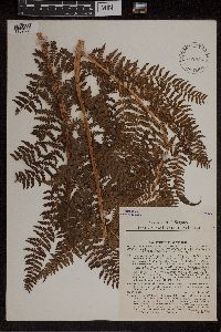 552888[1309302]Krajina, Vlad 2071931-09-10 Slovakia, septentrionalis: montes Vysoké Tatry,... in Mugheto explentibus in valle Mlynica [the north: the mountains of High Tatry, in the Mugheto fulfilling his commands, in the valley of Mlynica], 49.136368 20.243862, 1580m |
MIN:Plants | 256378[1310452]Holuby Slovakia, Detailed locality information protected. This is typically done to protect rare or threatened species localities. |
MIN:Plants | Epipactis palustris (L.) Crantz, Stirp. Austr. Fasc. 552941[1310469]Domin, K. Slovakia, Detailed locality information protected. This is typically done to protect rare or threatened species localities. |
MIN:Plants | Epipactis rubiginosa Crantz, Stirp. Austr. Fasc. 92732[1310493]Kupeok, Samuel Slovakia, Detailed locality information protected. This is typically done to protect rare or threatened species localities. |
MIN:Plants | Goodyera repens (L.) R. Brown 552634[1313270]Domin, K Slovakia, Detailed locality information protected. This is typically done to protect rare or threatened species localities. |
MIN:Plants | Goodyera repens (L.) R. Brown 552812[1313282]Sillinger, Pav. Slovakia, Detailed locality information protected. This is typically done to protect rare or threatened species localities. |
MIN:Plants | 552562[1316622]Sillinger, P. Slovakia, Detailed locality information protected. This is typically done to protect rare or threatened species localities. |
MIN:Plants | Orchis purpurea Huds. 552595[1316822]Cervenka, M. Slovakia, Detailed locality information protected. This is typically done to protect rare or threatened species localities. |
MIN:Plants | 552600[1316880]Domin, K Slovakia, Detailed locality information protected. This is typically done to protect rare or threatened species localities. |
MIN:Plants | 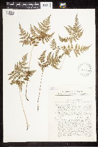 Cystopteris montana (Lamarck) Bernhardi ex Desvaux 552663[1322417]Domin, K. s.n.1929-07-10 Slovakia, septentrionalis: montis Bielské Tatry; Konsky Zleb prope Javorina, 1130m |
MIN:Plants | 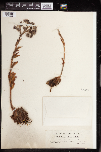 Sempervivum assimile Schott 122518[1343982]Wolff, G. 1739 Slovakia, Transsilvania. In rupibus "Tordai hasadek" near Tordam [Tordaméc, Tvrdomestice], 48.636602 18.132043 |
MIN:Plants | 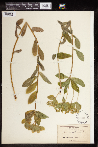 148219[1376560] Slovakia |
MIN:Plants | 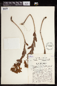 Euphorbia pannonica Host 552876[1376684] Slovakia |
MIN:Plants | 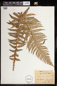 Polystichum aculeatum (L.) Roth ex Mert. 58488[1379900] Slovakia |
1
Page 1, records 1-15 of 15
Google Map
Google Maps is a web mapping service provided by Google that features a map that users can pan (by dragging the mouse) and zoom (by using the mouse wheel). Collection points are displayed as colored markers that when clicked on, displays the full information for that collection. When multiple species are queried (separated by semi-colons), different colored markers denote each individual species.