University of Minnesota
http://www.umn.edu/
612-625-5000
http://www.umn.edu/
612-625-5000
Minnesota Biodiversity Atlas
Bell Museum
Dataset: MIN-Plants
Taxa: Adoxaceae
Search Criteria: excluding cultivated/captive occurrences
Bell Museum plants | |
 MIN:Plants | Viburnum NULL 463461[]Lakela, Olga 142291952-06-18 United States, Minnesota, Saint Louis, on Namakan Narrows, St. Louis Co.;Voyageurs National Park;069N;17W;, 48.4282435 -92.5270181 |
MIN:Plants | Viburnum edule (Michaux) Rafinesque 907605[]Smith, Welby; et al. 309522008-06-19 United States, Minnesota, Cook, Cook County...About 3 miles south of McFarland Lake, in Grand Portage State Forest...T 64N R 3E NW1/4 of NW1/4 of Sec 27;Grand Portage State Forest;064N;03E;27, 48.0030556 -90.0505556 |
MIN:Plants | Viburnum edule (Michaux) Rafinesque 918172[]Gerdes, Lynden 59572009-07-14 United States, Minnesota, Cook, Superior National Forest. T64N R04E S28NWNWNENE. Cook County, MN. Superior National Forest. Pigeon River Purchase Unit. Approximately 0.35 miles southwest of the Pigeon River and Swamp River confluence...NAD 83 / 728689 / 5320831. 064N 04E 28, 47.9997222 -89.9341667 |
MIN:Plants |  Viburnum edule (Michaux) Rafinesque 462045[1329977]Smith, Welby 274871998-08-04 United States, Minnesota, Cook, Cook County ... On the north side of Big Susie Island in Lake Superior ... T 64N R 7E SE1/4 of SE1/4 of Sec 32;North Shore / Susie Islands, The Nature Conservancy;063N;07E;32, 47.9783325 -89.5741653 |
MIN:Plants |  Viburnum edule (Michaux) Rafinesque 482141[1329976]Gerdes, Lynden 25411998-05-29 United States, Minnesota, Cook, Boundary Waters Canoe Area Wilderness / Superior National Forest. T65N R01W S34NWNW. Cook County; Superior National Forest, BWCAW, Caribou Rock Hiking Trail vicinity of Duncan Lake.. 065N 01W 34, 48.06986 -90.43821 |
MIN:Plants |  Viburnum edule (Michaux) Rafinesque 918169[1329974]Gerdes, Lynden 57212009-06-03 United States, Minnesota, Cook, T64N R03E S12SWNENWSW. Cook County, MN. Superior National Forest. South Fowl Cliff...NAD 83 / 723097 / 5325377;Superior National Forest;064N;03E;12, 48.0425 -90.0066667 |
MIN:Plants | Viburnum edule (Michaux) Rafinesque 196039[]Cheney, L. s.n.1891-06-20 United States, Minnesota, Cook, Grand Marais;North Shore;060N;01E;, 47.750447 -90.334273 |
MIN:Plants | Viburnum edule (Michaux) Rafinesque 196040[]Rosendahl, C. 26341912-08-26 United States, Minnesota, Cook, Along the North shore Kimball Creek. Cook Co.;Grand Portage Indian Reservation / North Shore;061N;02E;, 47.7906709 -90.2059909 |
MIN:Plants | Viburnum edule (Michaux) Rafinesque 225012[]Rosendahl, C.; Butters, F. 44881924-06-30 United States, Minnesota, Cook, In gorge of Caribou River, North Shore, Lake Superior. Cook Co.;North Shore / Superior National Forest;060N;03W;, 47.6774443 -90.7068914 |
MIN:Plants | Viburnum edule (Michaux) Rafinesque 225013[]Rosendahl, C.; Butters, F. 45321924-07-01 United States, Minnesota, Cook, Near mouth of Brule River. Cook Co.;Judge Magney State Park / North Shore;062N;03E;, 47.8498363 -90.0649488 |
MIN:Plants | Viburnum edule (Michaux) Rafinesque 273240[]Rosendahl, C. 59951929-08-10 United States, Minnesota, Cook, Along the W side of Hat Point, Grand Portage Bay;Grand Portage Indian Reservation / North Shore;N;;, 47.9621 -89.650704 |
MIN:Plants | Viburnum edule (Michaux) Rafinesque 294508[]Butters, F.; Buell, Murray 4031932-07-12 United States, Minnesota, Cook, S side of Clearwater Lake. T65N, R1E;Boundary Waters Canoe Area Wilderness / Superior National Forest;065N;01E;, 48.0810547 -90.3151891 |
MIN:Plants | Viburnum edule (Michaux) Rafinesque 351290[]Benner, F.; Benner, J. 6321929-08-21 United States, Minnesota, Cook, 2 mi. E of Grand Portage, on road to Hat Point.;Grand Portage Indian Reservation / North Shore;N;;, 47.963768 -89.641581 |
MIN:Plants | Viburnum edule (Michaux) Rafinesque 351590[]Benner, F.; Benner, J. 5541929-07-27 United States, Minnesota, Cook, 1 mi. E of Grand Portage;Grand Portage Indian Reservation / North Shore;063N;06E;, 47.9584678 -89.7035757 |
MIN:Plants | Viburnum edule (Michaux) Rafinesque 371706[]Lakela, Olga 47851941-08-17 United States, Minnesota, Cook, Shore of Lake Superior at Lutsen. Cook Co.;North Shore / Superior National Forest;060N;03W;, 47.6774443 -90.7068914 |
MIN:Plants | Viburnum edule (Michaux) Rafinesque 393277[]Ownbey, Gerald; et al. 10781948-08-14 United States, Minnesota, Cook, Cook County...East end of Little Brick Island, Susie Islands near Grand Portage.;Grand Portage Indian Reservation / North Shore;063N;07E;, 47.973776 -89.568422 |
MIN:Plants | Viburnum edule (Michaux) Rafinesque 393952[]Butters, F.; Abbe, E. 9461944-08-06 United States, Minnesota, Cook, Cliff 2B, Clearwater Lake. T65N, R1E.;Boundary Waters Canoe Area Wilderness / Superior National Forest;065N;01E;, 48.0810547 -90.3151891 |
MIN:Plants | Viburnum edule (Michaux) Rafinesque 393953[]Butters, F.; Abbe, E.; Abbe, L. 2931937-07-05 United States, Minnesota, Cook, At E end of Mountain Lake. T65N, R2E.;Boundary Waters Canoe Area Wilderness / Superior National Forest;065N;02E;, 48.0861239 -90.1864827 |
MIN:Plants | Viburnum edule (Michaux) Rafinesque 393954[]Butters, F.; et al. s.n.1935-06-30 United States, Minnesota, Cook, Hat Point, Grand Portage. T63N, R6E.;Grand Portage Indian Reservation / North Shore;063N;06E;, 47.9584678 -89.7035757 |
MIN:Plants | Viburnum edule (Michaux) Rafinesque 393955[]Burns, G.; Hendrickson, M. 3941938-08-07 United States, Minnesota, Cook, At the base of cliff on the E side of Little Caribou Lake. T65N, R1E;Boundary Waters Canoe Area Wilderness / Superior National Forest;065N;01E;, 48.0810547 -90.3151891 |
MIN:Plants | Viburnum edule (Michaux) Rafinesque 393956[]Butters, F.; et al. 101938-07-03 United States, Minnesota, Cook, Cliff 2b, S side of Clearwater Lake. ;Boundary Waters Canoe Area Wilderness / Superior National Forest;065N;01E;, 48.0810547 -90.3151891 |
MIN:Plants | Viburnum edule (Michaux) Rafinesque 393957[]Burns, G.; Hendrickson, M. 3131938-07-27 United States, Minnesota, Cook, Gorge of Pigeon River just below outlet of South Fowl Lake. T64N, R3E. Cook Co.;Pigeon River Cliffs, The Nature Conservancy / Superior National Forest;064N;03E;12, 48.044201 -90.0032544 |
MIN:Plants | Viburnum edule (Michaux) Rafinesque 393958[]Butters, F.; Burns, G. 108241939-07-02 United States, Minnesota, Cook, Above Pigeon River at lower end of South Fowl Lake. T64N, R3E. Cook Co.;Pigeon River Cliffs, The Nature Conservancy / Superior National Forest;064N;03E;12, 48.044201 -90.0032544 |
MIN:Plants | Viburnum edule (Michaux) Rafinesque 393959[]Butters, F.; Burns, G. 7371940-07-06 United States, Minnesota, Cook, N shore of Morrison's Bay, Pigeon Point. T64N, R7E.;Grand Portage Indian Reservation / North Shore;064N;07E;, 47.9940093 -89.5751116 |
MIN:Plants | Viburnum edule (Michaux) Rafinesque 393960[]Dahl, A. 1231945-06-19 United States, Minnesota, Cook, Alongside cliff 2B on N shore of Clearwater Lake;Boundary Waters Canoe Area Wilderness / Superior National Forest;065N;01E;28, 48.0848591 -90.335202 |
MIN:Plants | Viburnum edule (Michaux) Rafinesque 405102[]Rosendahl, C. 78711947-09-21 United States, Minnesota, Cook, West of stockade, Grand Portage. Cook Co.;Grand Portage National Monument / North Shore;063N;06E;, 47.9584678 -89.7035757 |
MIN:Plants | Viburnum edule (Michaux) Rafinesque 583237[]Kellner, H. 5161956-06-14 United States, Minnesota, Cook, Cook Co.; On the N-facing side of Rose Mt, Grand Portage;Grand Portage National Monument / North Shore;063N;06E;, 47.9584678 -89.7035757 |
MIN:Plants | Viburnum edule (Michaux) Rafinesque 590224[]Voss, E. 101181961-07-18 United States, Minnesota, Cook, Cook Co.; Near mouth of Pigeon River;Grand Portage Indian Reservation / North Shore;064N;07E;, 47.9940093 -89.5751116 |
MIN:Plants |  Viburnum edule (Michaux) Rafinesque 723847[1329979]Smith, Welby; Coffin, Barbara; Berlin, N. 25631980-06-20 United States, Minnesota, Cook, T63N, R7E ... The NW side of Little Brick Island, in the Susie Island system; Lake Superior;North Shore / Susie Islands, The Nature Conservancy;063N;07E;, 47.9744453 -89.5688858 |
MIN:Plants | Viburnum edule (Michaux) Rafinesque 477046[]Anonymous 590224 United States, [no data] |
MIN:Plants |  Viburnum edule (Michaux) Rafinesque 462033[1329978]Smith, Welby 274791998-08-05 United States, Minnesota, Cook, Cook County ... At the far western tip of Susie Island, in Lake Superior ... T 63N R 7E NW1/4 of SW1/4 of Sec 5;North Shore / Susie Islands, The Nature Conservancy;063N;07E;05, 47.9677773 -89.5888901 |
MIN:Plants | Viburnum edule (Michaux) Rafinesque 918166[]Gerdes, Lynden; et al. 57402009-06-15 United States, Minnesota, Cook, Boundary Waters Canoe Area Wilderness / Superior National Forest. T65N R01E S28 NESWSESW Cook County ... Superior National Forest. Boundary Waters Canoe Area Wilderness. Clearwater Lake ... NAD 83 / ~698385 / 5329072. 065N 01E 28, 48.0838889 -90.3361111 |
MIN:Plants |  Viburnum edule (Michaux) Rafinesque 493268[1329982]Gerdes, Lynden 33601999-05-28 United States, Minnesota, Cook, T64N R03E S12NWSW Cook County ... Superior National Forest. South Fowl Lake Cliff. Between cliff edge and hiking trail.;Superior National Forest;064N;03E;12, 48.044201 -90.0032544 |
MIN:Plants |  Viburnum edule (Michaux) Rafinesque 918158[1329975]Gerdes, Lynden 57462009-06-18 United States, Minnesota, Cook, Superior National Forest. T64N R03E S12SENWNWSW. Cook County, MN. Superior National Forest. South Fowl Registry site [=wilderness access site]...NAD 83 / 722927 / 5325379. 064N 03E 12, 48.0427778 -90.0088889 |
MIN:Plants |  Viburnum edule (Michaux) Rafinesque 476715[1329980]Gerdes, Lynden 40052000-07-05 United States, Minnesota, Lake, North Shore. T57N R06W S18SENW. Lake County ... Mary's Mountain. Little Marais, MN. Feature approx. 1.0 miles west of the Hwy 61 and Lake Cty. 6 junction.. 057N 06W 19, 47.4080413 -91.1400076 |
MIN:Plants |  Viburnum edule (Michaux) Rafinesque 489153[1329981]Gerdes, Lynden 48922004-08-04 United States, Minnesota, Lake, Superior National Forest. T61N R07W S31NWSW. Lake County...Superior National Forest. Approximately 8.25 miles NE of Isabella, MN and 0.04 NW of Sylvania Lake.. 061N 07W 31, 47.723478 -91.2672179 |
MIN:Plants | Viburnum edule (Michaux) Rafinesque 919405[]Gerdes, Lynden; et al. 57362009-06-14 United States, Minnesota, Cook, Boundary Waters Canoe Area Wilderness / Superior National Forest. T65N R02E S13SWSW. Cook County, MN. Superior National Forest. Boundary Waters Canoe Area Wilderness. approximately 0.11 miles south of Fan Lake...NAD 83 / 712620 / 5332531. 065N 02E 13, 48.1105556 -90.1433333 |
MIN:Plants | Viburnum edule (Michaux) Rafinesque 947443[]Dziuk, Peter M. PMD15-0292015-06-24 United States, Minnesota, Cook, Artist's Point, North peninsula, just off south edge of northern beach. T61N R1E Sec. 21, 47.7455 -90.331803 |
MIN:Plants | 794926[]Schaaf, J. 141982-08-16 United States, Nevada, Humboldt, Pine Canyon, Santa Rosa Mts.;;;;, 36.25611 -115.60667, 1585m |
MIN:Plants | 510967[]Bright, R. 73-2251973-00-00 United States, Idaho, Bannock, [no further data] |
MIN:Plants | 510968[]Univ. of Calif. Bot. Gard. list 17 - 91974-00-00 United States, California, San Mateo, San Mateo Co. |
MIN:Plants | 431914[]Pistarino, A. 12181992-08-17 Italy, Valle d'Aosta, Aosta |
MIN:Plants |  972382[1395932]Janssens, J. 1911974-06-12 Belgium, Kiel |
MIN:Plants |  972385[1395935]Janssens, J. 75/1381975-06-14 Belgium, L. O. |
MIN:Plants | 510374[]US Nat. Arboretum staff 1976-511976-00-00 United States, New Jersey, Burlington, Burlington Co. |
MIN:Plants | 510373[]US Nat. Arboretum staff 1976-521976-00-00 United States, New Jersey, Burlington, Burlington Co. |
MIN:Plants | 510372[]US Nat. Arboretum staff 1974-321974-00-00 United States, District of Columbia, USNA [Nat. Arboretum] |
MIN:Plants | 897129[]Smith, Welby 274271998-07-23 United States, Minnesota, Renville, Renville County...On the railroad right-of-way that runs adjacent to State Highway 212, about 1/2 mile west of its junction with County Road 34...T 115N R 33W SE1/4 of NW1/4 of Sec 22. 115N 33W 22, 44.7547222 -94.8061111 |
MIN:Plants | 914225[]Smith, Welby 228011993-07-10 United States, Minnesota, Steele, Steele County ... At the rest area on Interstate 35, about 5 miles south of Owatonna...north side of the Straight River...T106N R20W SW1/4 of NE1/4 of Sec 17. 106N 20W 17, 43.9863889 -93.2522222 |
MIN:Plants | 511150[]US Nat. Arboretum staff 1978-521978-00-00 United States, Ohio, Clermont, Clermont Co. |
MIN:Plants | 426795[]Arboretum, Cary 73-131973-00-00 United States, New York, Dutchess, Dutchess Co. |
MIN:Plants | 920459[]Smith, Welby 257181995-07-06 United States, Minnesota, Wabasha, Wabasha County ... Weaver Dunes Preserve, about 4.5 miles southeast of Kellogg ... T109N R9W NE1/4 of NW1/4 of Sec 8;;109N;09W;08, 44.2630556 -91.92 |
MIN:Plants | 897502[]Smith, Welby 292322001-07-10 United States, Minnesota, Pine, Pine County ... Along Hwy 23 in the town of Askov ... T43N R19W NE1/4 of SW1/4 of Sec 20;;043N;19W;20, 46.1930556 -92.7697222 |
MIN:Plants |  459121[1334401]Smith, Welby 170711990-06-27 United States, Minnesota, Martin, Martin Co.; Bright Lake County Park, about 2.5 miles NE of Ceylon; T101N R31W SW1/4 of NE1/4 of Sec 17;;101N;31W;17, 43.5533333 -94.7047195 |
MIN:Plants | 506759[]Smith, Welby 169051990-06-20 United States, Minnesota, Dodge, Dodge Co.; Dodge Center Creek Park. On the N side of Dodge Center Creek, and 1 mi W of the town of Dodge Center; etc;;107N;17W;28, 44.040554 -92.8780518 |
MIN:Plants | 506824[]Smith, Welby 170971990-06-28 United States, Minnesota, Waseca, Mueller Wildlife Management Area. Waseca Co. Mueller State Wildlife Management Area, about 2 mi NE of Waldorf; on the N side of Mott Lake; Waseca Co. Mueller State Wildlife Management Area, about 2 mi NE of Waldorf; on the N side of Mott Lake; T106N R24W SE1/4 of SE1/4 of Sec 23. 106N 24W 23, 43.9652786 -93.6672211 |
MIN:Plants |  506868[1334410]Smith, Welby 169631990-06-21 United States, Minnesota, Faribault, Fairbault [sic] Co.; at the public access at the N end of Rice Lake, about 4 mi NW of Delavan; Fairbault [sic] Co.; at the public access at the N end of Rice Lake, about 4 mi NW of Delavan; T104N R27W SW1/4 of NE1/4 of Sec 16. 104N 27W 16, 43.8116684 -94.0772247 |
MIN:Plants | 510357[]US Nat. Arboretum staff 1975-451975-00-00 United States, Maryland, Dutchess Co. [no such county in Maryland] |
MIN:Plants | 690721[]Shane, L. 77-621977-07-22 United States, New Hampshire, Coos, Coos County ... near Carter Notch Ponds, specifically west slope of the more northerly of the two ponds ... Ponds are at terminus of Nineteen Mile Brook Trail by AMC hut, White Mountain National Forest.., 1036m |
MIN:Plants | 510860[]US Nat. Arboretum staff 1974-241974-00-00 United States, Maryland, Anne Arundel, [no further data] |
MIN:Plants | 897503[]Smith, Welby 292312001-07-10 United States, Minnesota, Pine, Pine County ... About 3 miles south of Pine City ... T38N R21W SW1/4 of SW1/4 of Sec 16;;038N;21W;16, 45.775 -92.9775 |
MIN:Plants | 510966[]US Nat. Arboretum staff 1974-251974-00-00 United States, District of Columbia, Washington |
MIN:Plants | 904071[]Smith, Welby 280481999-07-21 United States, Minnesota, Lac Qui Parle, Lac Qui Parle County...Lac Qui Parle State Park...along the Lac Qui Parle River...T118N R42W SE1/4 of NE1/4 of Sec 15;Lac Qui Parle State Park;118N;42W;15, 45.0325 -95.9019444 |
MIN:Plants |  952600[1292192]Harrigan, A. s.n.1924-06-00 United States, Minnesota, Saint Louis, Greaney, 47.967145 -93.021006 |
MIN:Plants | []Timothy J. S. Whitfeld 37342023-07-18 United States, Minnesota, Washington, Crystal Spring Scientific and Natural Area; 0.4 miles northeast of the intersection of Scandia Trail North and Hwy 95, 45.2609 -92.7683, 279m |
MIN:Plants | 439225[]Cochran, Philip; et al. s.n.2002-10-10 United States, Minnesota, Winona, Winona Co, Farmer's Community Park, near Garvin Brook (T107N,R8W,S8);Dorer Memorial Hardwood State Forest;107N;08W;08, 44.0851132 -91.810374 |
MIN:Plants | 439223[]Cochran, Philip; et al. s.n.2002-10-10 United States, Minnesota, Winona, Winona Co, Farmer's Community Park, near Garvin Brook (T107N,R8W,S8);Dorer Memorial Hardwood State Forest;107N;08W;08, 44.0851132 -91.810374 |
MIN:Plants | 479217[]Kaul, R. 72921994-07-16 United States, Minnesota, Steele, Steele Co.; near Straight River south of Morehouse Park, Owatonna.;;107N;20W;, 44.0661118 -93.2260713 |
MIN:Plants | 904516[]Smith, Welby 256701995-06-12 United States, Minnesota, Le Sueur, Le Sueur County ... About one mile north of Ottawa ... T111N R26W SW1/4 of SW1/4 of Sec 22;;111N;26W;22, 44.3911111 -93.9438889 |
MIN:Plants | 439224[]Cochran, Philip; et al. s.n.2002-09-09 United States, Minnesota, Winona, Winona Co, Saint Mary's University campus (T107N,R7W,S29)...bluff along east side of Yon's Road.;;107N;07W;29, 44.0415032 -91.6901248 |
MIN:Plants | 505428[]Smith, Welby 272611998-06-17 United States, Minnesota, Cook, Boundary Waters Canoe Area Wilderness / Superior National Forest. Cook County ... Boundary Waters Canoe Area Wilderness, Superior National Forest, along the Cross River ... T65N R4W SW1/4 of SE1/4 of Sec 27. 065N 04W 27, 48.0802778 -90.7380556 |
MIN:Plants |  833981[1334367]Smith, Welby 198161991-07-31 United States, Minnesota, Todd, Grey Eagle Wildlife Management Area. Todd Co. Grey Eagle State Wildlife Management Area, about 4 mi W of Grey Eagle; Todd Co. Grey Eagle State Wildlife Management Area, about 4 mi W of Grey Eagle; T127N R33W SW1/4 of SE1/4 of Sec 9. 127N 33W 9, 45.8202782 -94.8366699 |
MIN:Plants | 439226[]Cochran, Philip; et al. s.n.2002-09-09 United States, Minnesota, Winona, Winona Co, Saint Mary's University campus (T107N,R7W,S29)...bluff along east side of Yon's Road.;;107N;07W;29, 44.0415032 -91.6901248 |
MIN:Plants | 438442[]Cochran, Philip; et al. s.n.2002-10-10 United States, Minnesota, Winona, Winona Co, Farmer's Community Park, near Garvin Brook (T107N,R8W,S8);Dorer Memorial Hardwood State Forest;107N;08W;08, 44.0851132 -91.810374 |
MIN:Plants | 477047[]Anonymous 366992 United States, [no data] |
MIN:Plants | 772687[]Smith, Welby R. 32090A2010-08-26 United States, Minnesota, Cook, At the public access to Irish Creek, about 6 miles north of Hovland. SW of SW of section;;063N;04E;17, 47.933333 -89.9666667 |
MIN:Plants |  950611[1290065]Schimpf, David J. DJS8542016-06-22 United States, Minnesota, Saint Louis, T50N R14W NE1/4 of SE1/4 of Sec15; Duluth, 46.813056 -92.090417 |
MIN:Plants | 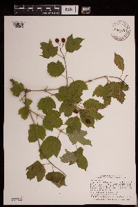 948408[1292540]Smith, Welby R. 341872012-08-17 United States, Minnesota, Jackson, Sangle State Wildlife Management Area, about 10.5 miles (17 km) southwest of the town of Jackson.; T101N R36W sec21, 43.53875 -95.1724 |
MIN:Plants | 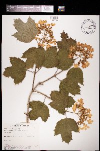 971887[1395722]Verbelen, E. 1551974-05-26 Belgium, Durme |
MIN:Plants | []Bourdaghs, Michael 2022-09-20 United States, Minnesota, Blue Earth, Site ID: 16BLUE290; Visit Number: 2727, 44.11753516 -94.19906323 |
MIN:Plants | 480624[]Smith, Welby 174021990-07-23 United States, Minnesota, Steele, Steele County ... Kaplan Woods City Park, on the south side of Owatonna ... T107N R20W NE1/4 of NW1/4 of Sec 21;;107N;20W;21, 44.0644444 -93.235 |
MIN:Plants | 429270[]Smith, Welby 285302000-06-15 United States, Minnesota, Otter Tail, Almora Wildlife Management Area. Otter Tail County ... Almora State Wildlife Management Area, about 0.75 mile west of Almora ... T 132N R 37W SW1/4 of NE1/4 of Sec 18. 132N 37W 18, 46.2466667 -95.3786111 |
MIN:Plants | 910984[]Smith, Welby 244931994-06-27 United States, Minnesota, Stearns, Stearns County... In Birch Lake State Forest, about 4 miles south of Grey Eagle... T127N R33W NE1/4 of NE1/4 of Sec 36;Birch Lakes State Forest;127N;33W;36, 45.7730556 -94.7705556 |
MIN:Plants | 490480[]Smith, Welby 266071997-06-12 United States, Minnesota, Itasca, Itasca County ... Along Hwy 1 where it crosses the Big Fork River ... T 62N R 25W SE1/4 of SW1/4 of Sec 23;Leech Lake Indian Reservation;062N;25W;23, 47.8408333 -93.5027778 |
MIN:Plants | 493436[]Smith, Welby 273041998-06-29 United States, Minnesota, Itasca, Itasca County...At the northwest end of Island Lake, about 3 mi south of Northome...T 150N R 28W SW1/4 of SW1/4 of sec 5;Chippewa National Forest;150N;28W;05, 47.8316667 -94.2625 |
MIN:Plants | 904594[]Smith, Welby 260891996-06-03 United States, Minnesota, Rock, Rock County ... Blue Mounds State Park, about 3 miles N-NE of Luverne... Rock Creek...T103N R45W NW1/4 of NW1/4 of Sec24;Blue Mounds State Park;103N;45W;24, 43.7163889 -96.1897222 |
MIN:Plants | 914560[]Smith, Welby 225181993-06-18 United States, Minnesota, Douglas, Douglas County...Lake Carlos State Park, about 6 miles north of Alexandria... T129N R 37W SE1/4 of SW 1/4 of Sec 9;Lake Carlos State Park;129N;37W;09, 45.9958333 -95.3469444 |
MIN:Plants | 913128[]Scott, P. 27022006-08-24 United States, Minnesota, Lake, Lake Co. ...S. Kawishiwi River, SNF. T62N R11W sec. 23 SENE.;Superior National Forest;062N;11W;23, 47.8413189 -91.6937992 |
MIN:Plants | 475271[]Smith, Welby 288272000-07-26 United States, Minnesota, Aitkin, Aitkin County ... Savanna Portage State Park; about one mile west of Shumway Lake ... T50N R22W SW1/4 of SE1/4 of Sec 7;Savanna Portage State Park;050N;22W;07, 46.8286095 -93.1744461 |
MIN:Plants | 910709[]Rowe, Erika ERR2852007-08-30 United States, Minnesota, Hubbard, Hubbard County...3 miles NNE of Laporte; 1.85 miles east of Cty Rd 36; 85 meters east of old railroad bed turned snowmobile trail...T144N R32W SENE S30. 144N 32W 30, 47.2608333 -94.7736111 |
MIN:Plants | 919222[]Gerdes, Lynden; et al. 59062009-08-25 United States, Minnesota, Cook, Boundary Waters Canoe Area Wilderness / Superior National Forest. T66N R05W S12SWNENWSW. Cook County, MN. Superior National Forest. Boundary Waters Canoe Area Wilderness. Saganaga Lake. Munker Island.. 066N 05W 12, 48.2151183 -90.9125223 |
MIN:Plants | 515408[]Scott, P. 13142001-08-10 United States, Minnesota, Cook, COOK CO ... Voyageur Island, Saganaga Lake, BWCAW. T66N R5W sec.1 SENESW.;Boundary Waters Canoe Area Wilderness / Superior National Forest;066N;05W;01, 48.2286502 -90.910713 |
MIN:Plants | 510375[]US Nat. Arboretum staff 77-631977-00-00 United States, Maryland, Montgomery, Montgomery Co. |
MIN:Plants | 498986[]Smith, Welby 266031997-06-12 United States, Minnesota, Beltrami, Beltrami County ... Along Hwy 71 about 3 miles SE of Funkley ... T149N R30W NE1/4 of NE1/4 of Sec 4;;149N;30W;04, 47.7577778 -94.4861111 |
MIN:Plants | 567994[]Gerdes, Lynden 51072006-05-23 United States, Minnesota, Itasca, George Washington State Forest. T62N R24W S08SWSWSW Itasca County ... George Washington State Forest. Approximately 9.09 miles ENE of Effie, MN and 0.03 mile E of Cty. Rd. 525.. 062N 24W 8, 47.873022 -93.4337424 |
MIN:Plants | 461870[]Kaul, R. 62321988-08-24 United States, Minnesota, Steele, Steele Co.; along the Straight River near the Lemond Road.;;107N;20W;, 44.0661118 -93.2260713 |
MIN:Plants | 915832[]Whitfeld, T.J.S. 6652006-05-25 United States, Minnesota, Hubbard, Hubbard County...1/2 mi S of Blacksmith Lake; 2 mi SE of Coon Lake Forest Road...UTM (NAD83): E344327 N5218696;;142N;35W;24, 47.1033333 -95.0516667 |
MIN:Plants | 493670[]Smith, Welby 266061997-06-12 United States, Minnesota, Koochiching, Koochiching County ... On the north side of Hwy 1, about 3 mi east of Northome ... T 151N R 28W SW1/4 of SW1/4 of Sec 24;;151N;28W;24, 47.875 -94.1861115 |
MIN:Plants | 453133[]Smith, Welby 290432000-08-24 United States, Minnesota, Sherburne, Sherburne National Wildlife Refuge. Sherburne County ... Sherburne National Wildlife Refuge. Along the Mahnomen Trail on the north side of Rice Lake ... T 35N R 27W NW1/4 of NW1/4 of Sec 26. 035N 27W 26, 45.4980545 -93.6511078 |
MIN:Plants | 489623[]Smith, Welby 270481998-05-12 United States, Minnesota, Koochiching, Koochiching County...Where County Road 5 crosses the Big Fork River at Craigville...T 63N R 26W SE1/4 of NW1/4 of Sec 36;Koochiching State Forest;063N;26W;36, 47.9069443 -93.6108322 |
Google Map
Google Maps is a web mapping service provided by Google that features a map that users can pan (by dragging the mouse) and zoom (by using the mouse wheel). Collection points are displayed as colored markers that when clicked on, displays the full information for that collection. When multiple species are queried (separated by semi-colons), different colored markers denote each individual species.