University of Minnesota
http://www.umn.edu/
612-625-5000
http://www.umn.edu/
612-625-5000
Minnesota Biodiversity Atlas
Bell Museum
Dataset: MIN-Plants
Taxa: Araceae
Search Criteria: excluding cultivated/captive occurrences
Bell Museum plants | |
 MIN:Plants |  580647[1332955] Trinidad and Tobago |
MIN:Plants |  509134[1335384]Hogg, M. R. s.n.1951-03-24 United States, Louisiana, Lincoln, 3 mi S of Choudrant, 32.486612 -92.514312 |
MIN:Plants |  764141[1335450]Lugger, O. s.n.1876-05-11 United States, Maryland, Patuxent River, 38.811589 -76.712246 |
MIN:Plants |  765322[1335451]Hays, W.M. s.n. United States, Iowa, Ames, 42.034708 -93.61994 |
MIN:Plants |  583715[1335487]Rugel, F. 471844-05-00 United States, Florida, Pinus canadensis region of the Smoky Mountains. |
MIN:Plants |  84504[1337411]G. Schweinforth 11111869-06-02 Sudan |
MIN:Plants |  919704[1337059]Nelson, John B. 244882004-03-05 United States, South Carolina, Sumter, Lake Marion within Santee River swamp, N of Sparkleberry Landing, 33.706556 -80.535252 |
MIN:Plants |  Anthurium myosuroides Sodiro 295765[1299160]Yuncker, T. 46151934-07-16 Honduras, ridge above Lancetilla;;;;, 15.7 -87.466667, 244m |
MIN:Plants |  Wolffia borealis (Engelmann) Landolt 920034[1337692]Smith, Welby 190171991-06-27 United States, Minnesota, Morrison, Camp Ripley Military Reservation. Camp Ripley Military Reservation. Morrison County...About 4 km east-southeast of Pillager, and 0.75 km north of Pusan Road...UTM: 388900E 5129900N. T 133N R 30W SW1/4 of SW1/4 of Sec 23. 133N 30W 23, 46.3155556 -94.4430556 |
MIN:Plants |  Wolffia borealis (Engelmann) Landolt 433198[1337710]Smith, Welby R. 148411988-08-12 United States, Minnesota, Washington, At the southwest end of Lake Elmo, about one mile south of the town of Lake Elmo; NW1/4 NE1/4 section 26, T 29N R 21W [Lake Elmo County Park], 44.9772224 -92.8911133 |
MIN:Plants |  Wolffia borealis (Engelmann) Landolt 526364[1337698]Moore, John W. 211101951-06-27 United States, Minnesota, Stearns, Sauk Lake, Sauk Center [T126N;R34W], 45.71615 -94.953516 |
MIN:Plants |  Wolffia borealis (Engelmann) Landolt 526365[1337697]Moore, John W. 211091951-06-27 United States, Minnesota, Stearns, Sauk Lake, Sauk Center. [T126N;R34W], 45.71615 -94.953516 |
MIN:Plants |  Wolffia borealis (Engelmann) Landolt 370718[1337700]Moore, John W. 137311940-10-05 United States, Minnesota, Scott, Fisher Lake, Minnesota River bottoms, 1/2 mile west of the Bloomington Bridge [Minnesota Valley National Wildlife Refuge; T27N;R22W], 44.7995 -93.40988 |
MIN:Plants |  Wolffia borealis (Engelmann) Landolt 448316[1337703]Moore, John W. 189201946-08-02 United States, Minnesota, Benton, Little Rock Lake, 7 miles north of Sauk Rapids [T37N;R31W], 45.73686 -94.16656 |
MIN:Plants |  Wolffia borealis (Engelmann) Landolt 572628[1337699]Moore, John W. 253951961-06-06 United States, Minnesota, Houston, Mississippi River 2 miles north of Brownsville. [Upper Mississippi National Wildlife Refuge; T103N;R3W], 43.723383 -91.27319 |
MIN:Plants |  Wolffia borealis (Engelmann) Landolt 371110[1337704]Moore, John W. 129801940-09-28 United States, Minnesota, Anoka, east side of the lake; 1/2 mile west of Bethel [T34N;R24W], 45.427962 -93.326981 |
MIN:Plants |  Wolffia borealis (Engelmann) Landolt 425851[1337706]Emanuel, J. P. 5671951-00-00 United States, Minnesota, Winona, East slough of the Prairie Is. Road from Winona [T107N;R7W], 44.052588 -91.672687 |
MIN:Plants |  Wolffia borealis (Engelmann) Landolt 433196[1337701]Smith, Welby R. 148421988-08-12 United States, Minnesota, Washington, At the southwest end of Lake Elmo, about one mile south of the town of Lake Elmo. NW1/4 NE1/4 section 26, T 29N R 21W. [Lake Elmo Country Park], 44.9772224 -92.8911133 |
MIN:Plants |  Wolffia borealis (Engelmann) Landolt 458804[1337695]Myhre, K. 68321997-07-04 United States, Minnesota, Morrison, Morrison Co.; Sullivan Lake. Located 15 mi NE of the town Pierz. Plants occur along the N bay of the lake; T42N R29W SW1 Morrison Co.; Sullivan Lake. Located 15 mi NE of the town Pierz. Plants occur along the N bay of the lake; T42N R29W SW1/4 of NE1/4 of Sec 1. 042N 29W 1, 46.149496 -93.946975 |
MIN:Plants |  Wolffia borealis (Engelmann) Landolt 508596[1311657]Myhre, K. 65211996-08-09 United States, Minnesota, Crow Wing, Crow Wing Co. Located 7 mi NE of Pequot Lakes; NE shores of Duck Lake; T137N R27W NW1/4 of SW1/4 of Sec 30;;137N;27W;30, 46.653138 -94.145909 |
MIN:Plants |  Wolffia borealis (Engelmann) Landolt 508598[1311659]Myhre, K. 65091996-08-07 United States, Minnesota, Crow Wing, Crow Wing Co. Located 19 mi NE of Pequot Lakes; channel leading into Mud Lake and the NE bay of lake; T137N R26W NW1/4 o Crow Wing Co. Located 19 mi NE of Pequot Lakes; channel leading into Mud Lake and the NE bay of lake; T137N R26W NW1/4 of SW1/4 of Sec 23. 137N 26W 23, 46.665756 -93.935482 |
MIN:Plants |  Wolffia borealis (Engelmann) Landolt 508600[1311656]Myhre, K. 63681996-06-27 United States, Minnesota, Aitkin, Aitkin Co. Located 1 mi W of Bennetville [sic]; Horseshoe Lake; T45N R27W NW1/4 of NW1/4 of Sec 9;;045N;27W;9, 46.395557 -93.759845 |
MIN:Plants |  Wolffia borealis (Engelmann) Landolt 515547[1311662]Myhre, K. 34991993-04-30 United States, Minnesota, Pine, Saint Croix State Forest. Pine Co.; located on the south outlet of the Hay Creek Flowage as it enters the Lower Tamarack River; T 42N R 16W NE1/4 Pine Co.; located on the south outlet of the Hay Creek Flowage as it enters the Lower Tamarack River; T 42N R 16W NE1/4 of SE1/4 of Sec 30. 042N 16W 30, 46.0916 -92.415029 |
MIN:Plants |  Wolffia borealis (Engelmann) Landolt 572629[1337707]Moore, John W. 253911961-06-06 United States, Minnesota, Houston, Mississippi River, 2 miles north of Brownsville. [Upper Mississippi National Wildlife Refuge; T103N;R3W], 43.723383 -91.27319 |
MIN:Plants |  Wolffia borealis (Engelmann) Landolt 618983[1337696]Whitesides, Mel s.n.1970-08-15 United States, Minnesota, Becker, Lake Sallie, ca. 3.5 mi. SW of Detroit Lakes. [T138N;R41W], 46.760408 -95.858857 |
MIN:Plants |  Wolffia borealis (Engelmann) Landolt 739534[1337693]Kaul, R.; et al. 82-4011982-08-09 United States, Minnesota, Clearwater, Clearwater County...Itasca State Park. In roadside pond about 3/4 mile E of Bert's Cabins, North Boundary road.;Itasca State Park;143N;36W;, 47.19557 -95.233216 |
MIN:Plants |  Wolffia borealis (Engelmann) Landolt 833238[1311658]Myhre, K. 30931992-08-17 United States, Minnesota, Cass, Cass Co. Located 1 mi NW of Sylvan Lake; edge of the Crow Wing River; T133N R30W SW1/4 of NE1/4 of Sec 24;;133N;30W;24, 46.316245 -94.404584 |
MIN:Plants |  Wolffia borealis (Engelmann) Landolt 834137[1337708]Smith, Welby R. 201251991-09-10 United States, Minnesota, Aitkin, In Elm Island Lake, about 6 miles southeast of Aitkin. T 46N R 26W NE1/4 of NE1/4 of Sec 21, 46.458889 -93.625 |
MIN:Plants |  Wolffia borealis (Engelmann) Landolt 842489[1311655]Myhre, K. 57921995-07-01 United States, Minnesota, Crow Wing, Crow Wing Co. Located 4.5 mi NE of the town of Pequot Lakes. Plants occur along the W bays of Upper Whitefish Lake; T137 Crow Wing Co. Located 4.5 mi NE of the town of Pequot Lakes. Plants occur along the W bays of Upper Whitefish Lake; T137N R29W SE1/4 of NE1/4 of Sec 13. 137N 29W 13, 46.682255 -94.293169 |
MIN:Plants |  Wolffia borealis (Engelmann) Landolt 842821[1337694]Myhre, K. 58811995-07-14 United States, Minnesota, Crow Wing, Crow Wing Co. Located 5 mi SW of the town of Garrison. Plants occur along the SE shore of Camp Lake; T43N R28W NE1/4 of Crow Wing Co. Located 5 mi SW of the town of Garrison. Plants occur along the SE shore of Camp Lake; T43N R28W NE1/4 of NW1/4 of Sec 10.. 043N 28W 10, 46.221344 -93.862456 |
MIN:Plants |  Wolffia borealis (Engelmann) Landolt 842823[1299680]Myhre, K. 58091995-07-03 United States, Minnesota, Aitkin, Aitkin Co. Located 5 mi SW of the town of Aitkin. Plants occur along the SE bay of Cedar Lake; T46N R27W NW1/4 of NW1/4 Aitkin Co. Located 5 mi SW of the town of Aitkin. Plants occur along the SE bay of Cedar Lake; T46N R27W NW1/4 of NW1/4 of Sec 7.. 046N 27W 7, 46.482671 -93.801371 |
MIN:Plants |  Wolffia borealis (Engelmann) Landolt 842824[1337691]Myhre, K. 60251995-08-08 United States, Minnesota, Crow Wing, Crow Wing Co. Located 6 mi S of the town of Crosby; NE bay of Nokay Lake; T45N R29W NW1/4 of NW1/4 of Sec 13.;;045N;29W;13, 46.380859 -93.947081 |
MIN:Plants |  Wolffia borealis (Engelmann) Landolt 842826[1337709]Myhre, K. 61621995-08-23 United States, Minnesota, Aitkin, Located 4.5 miles south of the town of Aitkin. Plants occur along a northern bay of Hanging Kettle Lake. T 46N R 27W NW1/4 of NW1/4 of Sec 13, 46.467869 -93.696389 |
MIN:Plants |  Wolffia borealis (Engelmann) Landolt 842828[1311661]Myhre, K. 62681995-09-13 United States, Minnesota, Aitkin, Aitkin Co. Located 4 mi NW of the town of McGregor. Plants occur along the NW channel of Steamboat Lake; T48N R24W NE1/4 Aitkin Co. Located 4 mi NW of the town of McGregor. Plants occur along the NW channel of Steamboat Lake; T48N R24W NE1/4 of SE1/4 of sec 15.. 048N 24W 15, 46.64482 -93.37023 |
MIN:Plants |  Wolffia borealis (Engelmann) Landolt 842829[1311660]Myhre, K. 61941995-08-29 United States, Minnesota, Aitkin, Aitkin Co. Located 5 mi SE of the town of Aitkin. Plants occur along a S bay of Ripple Lake; T46N R26W SW1/4 of NE1/4 of Aitkin Co. Located 5 mi SE of the town of Aitkin. Plants occur along a S bay of Ripple Lake; T46N R26W SW1/4 of NE1/4 of Sec 19.. 046N 26W 19, 46.453572 -93.674886 |
MIN:Plants |  Wolffia borealis (Engelmann) Landolt 446625[1337705]Moore, John W. 183931945-10-16 United States, Minnesota, Stearns, Horseshoe Lake at Richmond [T123N;R31W], 45.455613 -94.572732 |
MIN:Plants |  Wolffia borealis (Engelmann) Landolt 834257[1337702]Monson, Paul H. 46811964-08-23 United States, Minnesota, Mahnomen, R-40, T-143, S-27. Small pond on S side of Hwy.113, 9.6 mi E of Waubun [White Earth Indian Reservation / White Earth State Forest], 47.172302 -95.731705 |
MIN:Plants |  Wolffia borealis (Engelmann) Landolt 932743[1293498]Lee, Michael MDL48732008-09-25 United States, Minnesota, Wadena, Along the Crow Wing River upstream from Knob Hill, 2.5 miles south-southwest of Oylen, 7.5 miles south-southeast of Nimrod. E1/2 of SE1/4 of NW1/4 of section;;135N;33W;02, 46.5377963 -94.8119531 |
MIN:Plants |  Wolffia borealis (Engelmann) Landolt 84701[1337743]Brinton, J. Bernard s.n.1890-08-20 United States, Pennsylvania, Philadelphia, Philadelphia; Girard Pond, 39.952584 -75.165222 |
MIN:Plants |  Wolffia borealis (Engelmann) Landolt 346516[1337744]Moyle, J. B. 26791932-08-20 United States, Wisconsin, Racine, Stork's Lake, near Rochester, 42.74139 -88.22417 |
MIN:Plants |  Wolffia borealis (Engelmann) Landolt 291378[1337745]Muensher, W. C. 21161931-08-29 United States, New York, Saint lawrence, Inlet, Indian River and Bay, Black Lake, 44.51872 -75.589155 |
MIN:Plants |  Wolffia borealis (Engelmann) Landolt 389601[1337746]McFarland, Frank T. 911940-10-11 United States, Kentucky, Fayette, Large pond 2 miles E of Lexington, along C and O RR, 38.033294 -84.463185 |
MIN:Plants |  Wolffia borealis (Engelmann) Landolt 389597[1337747]Hermann, F. J. 73371935-09-22 United States, Michigan, Washtenaw, overflow of Huron River, 2 miles E Ann Arbor, 42.278969 -83.707688 |
MIN:Plants |  Wolffia borealis (Engelmann) Landolt 567264[1337748]Hunnewell, F. W. 117891930-08-14 United States, New York, Madison, Cazenovia Lake, 42.94722 -75.87111 |
MIN:Plants |  Wolffia borealis (Engelmann) Landolt 336821[1337749]Hermann, F. J. 6968; 69671935-08-15 United States, Michigan, Washtenaw, Huron River at Geddes Ave Bridge; 2.5 miles E Ann Arbor, 42.278969 -83.707688 |
MIN:Plants |  Wolffia borealis (Engelmann) Landolt 337492[1337750]Hermann, F. J. 6391935-08-24 United States, Michigan, Washtenaw, Huron River; 2 miles E Ann Arbor, 42.278969 -83.707688 |
MIN:Plants |  Wolffia borealis (Engelmann) Landolt 424199[1337751]Fassett, N. C. 53181924-08-24 United States, Wisconsin, Trempealeau |
MIN:Plants |  Peltandra virginica (L.) Schott 440412[1311633;1311634]Argue, C. s.n.1995-07-24 United States, Minnesota, Cook, Cook Co. T65N R2W, Gunflint Trail, end of southern arm of Iron Lake, in bay to the E.;Superior National Forest;065N;02W;, 48.06277 -90.627523 |
MIN:Plants | 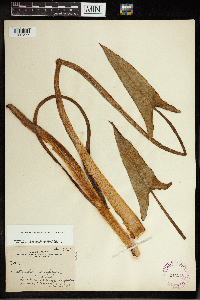 Peltandra virginica (L.) Schott 244346[1337377]Harris, J. Arthur C161711916-02-25 United States, Florida, Dade, Everglades, south of Florida City;Everglades National Park;;;, 25.3125 -80.9375 |
MIN:Plants | 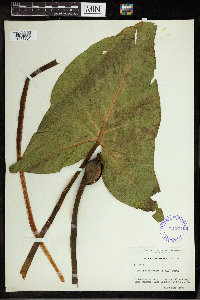 Peltandra virginica (L.) Schott 291374[1337361]Muensher, W. C. 21081931-08-25 United States, New York, Jefferson, lagoon, Wilson Bay, Lake Ontario, 44.086136 -76.352744 |
MIN:Plants | 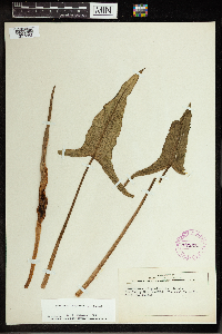 Peltandra virginica (L.) Schott 279528[1337362]Carpenter, Dana S. s.n.1927-07-06 United States, Vermont, Bennington |
MIN:Plants | 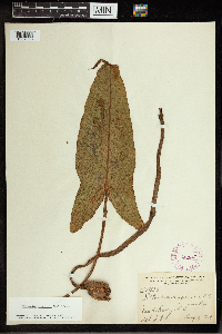 Peltandra virginica (L.) Schott 262843[1337363]Harris, J. Arthur 196841919-08-01 United States, South Carolina, Dawho River, 32.627126 -80.272043 |
MIN:Plants |  Peltandra virginica (L.) Schott 84491[1337364]Foltz, Kent O. s.n.1889-07-10 United States, Ohio, Summit, Akron; Blue Pond, 41.066459 -81.475202 |
MIN:Plants |  Peltandra virginica (L.) Schott 389580[1337365]Dowell, Philip 33701904-09-11 United States, New York, Richmond, Grant City, 40.582049 -74.104864 |
MIN:Plants |  Peltandra virginica (L.) Schott 84489[1337366]Durand, E. J. s.n.1894-06-19 United States, New York, Tompkins, Ithaca, Cayuga St., 42.440628 -76.496607 |
MIN:Plants |  Peltandra virginica (L.) Schott 278336[1337367]Stokes, Jos. s.n. United States, New Jersey, Burlington, Atsion, 39.742618 -74.725992 |
MIN:Plants |  Peltandra virginica (L.) Schott 84499[1337368]Kearney, T. H. s.n. United States, Tennessee, Knox |
MIN:Plants |  Peltandra virginica (L.) Schott 84496[1337370]Umbach, L. M. s.n.1898-06-29 United States, Indiana, Clark |
MIN:Plants |  Peltandra virginica (L.) Schott 246271[1337371]Umbach, L. M. s.n.1898-06-29 United States, Indiana, Clark |
MIN:Plants |  Peltandra virginica (L.) Schott 263200[1337372]Harris, J. Arthur 191741919-07-19 United States, North Carolina, Bogue Sound, 34.696551 -76.935776 |
MIN:Plants |  Peltandra virginica (L.) Schott 263301[1337373]Harris, J. Arthur 193031919-07-05 United States, North Carolina, North River, 34.81639 -76.63611 |
MIN:Plants |  Peltandra virginica (L.) Schott 263299[1337374]Harris, J. Arthur 193001919-07-05 United States, North Carolina, North River, 34.81639 -76.63611 |
MIN:Plants |  Peltandra virginica (L.) Schott 389581[1337375]Wadmond, S. C. s.n.1941-08-07 United States, Michigan, Kalamazoo, Barton Lake, near Schoolcraft, 42.114211 -85.637778 |
MIN:Plants |  Peltandra virginica (L.) Schott 439878[1337376]Nelson, John B. 126631992-06-01 United States, South Carolina, Richland, edge of Boyden Arbor Rd at Gill's Creek, 34.024044 -80.945645 |
MIN:Plants |  Peltandra virginica (L.) Schott 84500[1337378]Collins, F. S. s.n.1890-07-12 United States, Massachusetts, Middlesex |
MIN:Plants |  Peltandra virginica (L.) Schott 525224[1337379] s.n.1886-06-29 United States, District of Columbia, Eastern Branch, 38.876337 -76.976417 |
MIN:Plants |  Peltandra virginica (L.) Schott 84495[1337380]Hasse, H. E. s.n.1885-05-00 United States, Arkansas, Pulaski |
MIN:Plants |  Peltandra virginica (L.) Schott 84493[1337381]Steele, E. S. s.n.1896-05-29 United States, District of Columbia, River flats, 38.905089 -77.069977 |
MIN:Plants |  Peltandra virginica (L.) Schott 597923[1337383]Redford, A. E. 448431966-07-01 United States, North Carolina, Chatham, 3 miles S of Wilsonville, 35.689787 -79 |
MIN:Plants |  Peltandra virginica (L.) Schott 528879[1337384]Smith, L. B, s.n.1946-06-16 United States, Massachusetts, Middlesex, Aberjona River; Winchester, 42.451695 -71.135098 |
MIN:Plants |  Peltandra virginica (L.) Schott 246259[1337386]Deam, Mrs. Chas. C. 40261908-03-19 United States, Florida, Pinellas, near St. Petersburg at margin of Bay-head, 27.767601 -82.640291 |
MIN:Plants |  Peltandra virginica (L.) Schott 286723[1337387]Harris, J. Arthur 23761923-03-02 United States, Florida, Miami dade |
MIN:Plants |  Peltandra virginica (L.) Schott 244355[1337388]Harris, J. Arthur 171771917-02-23 United States, Florida, Miami dade |
MIN:Plants |  Peltandra virginica (L.) Schott 244356[1337389]Harris, J. Arthur 161931916-03-03 United States, Florida, Miami dade |
MIN:Plants |  Peltandra virginica (L.) Schott 523489[1337390]Cooper, William S. s.n.1902-06-17 United States, Michigan, Oakland, Cass Lake, 42.608243 -83.367779 |
MIN:Plants |  Peltandra virginica (L.) Schott 470217[1337391]Marie-Victorin, F. 22441943-08-22 Canada, Quebec, Richelieu, Lavalliere Bay; Along the Pot-au-Beurre stream., 45.079758 -72.951156 |
MIN:Plants |  Peltandra virginica (L.) Schott 84497[1337393] s.n. United States, New York |
MIN:Plants |  Peltandra virginica (L.) Schott 961136[1337369]Kearney, T. H. s.n. United States, Tennessee, Knox |
MIN:Plants |  Peltandra virginica (L.) Schott 961137[1337382]Hyams, M. E. s.n. United States, North Carolina, Iredell |
MIN:Plants |  Peltandra virginica (L.) Schott 961138[1337385]Nash., Geo. V. 4531894-04-00 United States, Florida, Lake, vicinity of Eustis, 28.852768 -81.685353 |
MIN:Plants |  Peltandra virginica (L.) Schott 961139[1337392] 12961896-06-05 United States, North Carolina, Buncombe, Biltmore, 35.558169 -82.533457 |
MIN:Plants |  910372[1335922]Loso, Stephanie; et al. 14312007-08-23 United States, Minnesota, Cass, Lake ID: 11050400, Steamboat Lake. Not exact location [collector provided invalid lat/long];Leech Lake Indian Reservation;144N;31W;20, 47.272279 -94.622915 |
MIN:Plants |  488242[1335893]Zager, S. 1122000-08-08 United States, Minnesota, Kanabec, Rice Creek Wildlife Management Area. Kanabec County ... Rice Creek Wildlife Management Area ... T38N R23W NW1/4 of NE1/4 of SE1/4 of Section 21 MCBS Site KA164. 038N 23W 21, 45.7669449 -93.2091675 |
MIN:Plants |  84616[1337120]Nelson, Aven; et al. 69291899-07-14 United States, Wyoming, Park, Yellowstone National Park...Trout Lake;Yellowstone National Park;;;, 44.900548 -110.129716 |
MIN:Plants |  910436[1335923]Vacinek, Brent; et al. 13912007-08-22 United States, Minnesota, Cass, County: Cass, Lake ID: 11038300, Lake: Pleasant...T140, R30W, Sec28, West shoreline. DNR Site # 84;;140N;30W;28, 46.914433 -94.480892 |
MIN:Plants |  493954[1335892]Crowell, Wendy; et al. s.n.2005-06-23 United States, Minnesota, Pope, Pope County, Lake Villard, public access;;126N;37W;13, 45.72274 -95.273317 |
MIN:Plants |  915862[1335890]Smith, Welby 224911993-06-18 United States, Minnesota, Grant, Grant County...On the south side of Ask Lake, about 1.5 miles east-southest of Ashby...T 130N R 41W NW1/4 of SW1/4 of Sec 12. 130N 41W 12, 46.0847222 -95.7886111 |
MIN:Plants |  910689[1335920]BioBlitz volunteers s.n.2009-06-13 United States, Minnesota, Ramsey, Ramsey Co, St. Paul, Crosby Farm Regional Park, Crosby Lake. T28N R23W Sec. 22;Hidden Falls - Crosby Farm Regional Park;028N;23W;22, 44.898874 -93.158011 |
MIN:Plants |  263710[1335965]Nurnberger, P. P28411928-08-13 United States, Minnesota, Aitkin, Big Sandy Lake.;Savanna State Forest;N;;, 46.72381 -93.254302 |
MIN:Plants |  275967[1335937]Grant, Martin 29291929-07-25 United States, Minnesota, Clearwater, Lake Itasca.;Itasca State Park;143N;36W;2, 47.231973 -95.201528 |
MIN:Plants |  276684[1335869]Fassett, N.C. 31971926-08-28 United States, Minnesota, Wabasha, Maloney Lake. Weaver. [Upper Mississippi National Wildlife Refuge; R109N;R9W], 44.233108 -91.917245 |
MIN:Plants | 333691[]Moore, John; Huff, N. 186451946-06-15 United States, Minnesota, Becker, Callaway.;White Earth Indian Reservation;141N;41W;, 47.020668 -95.87045 |
MIN:Plants |  346282[1335898]Moyle, J. 32391938-09-18 United States, Minnesota, Yellow Medicine, Near Granite Falls.;;N;;, 44.809958 -95.545575 |
MIN:Plants |  346286[1335916]Moyle, J. B. 32341938-09-18 United States, Minnesota, Yellow Medicine, W of Granite Falls, 44.809958 -95.545575 |
MIN:Plants |  353299[1335967]Lakela, Olga 24221938-06-05 United States, Minnesota, Saint Louis, In a lake on the road to Poupore from hwy. 2.;;N;;, 46.8725 -92.764444 |
MIN:Plants |  359218[1335858]Moyle, J. B. 33871939-08-00 United States, Minnesota, Crow Wing, Nokasippi River, 46.334077 -94.018174 |
MIN:Plants |  362671[1335930]Rosendahl, C. 66171934-09-12 United States, Minnesota, Clearwater, Mississippi River, at an outlet of Lake Itasca.;Itasca State Park;143N;36W;, 47.19557 -95.233216 |
MIN:Plants |  366977[1335938]Moore, John; Moore, Marjorie 104491938-09-12 United States, Minnesota, Wilkin, In the Bois de Sioux River, adjacent to hwy. 41, 1.03 mi. S of Breckenridge.;;N;;, 46.240081 -96.553133 |
MIN:Plants |  369895[1335877]Moore, John W. 130281940-06-19 United States, Minnesota, Blue Earth, West shore of Eagle Lake, S.E. 1/4, Section 1, Mankato Township [T108N;R26W], 44.188701 -93.898739 |
MIN:Plants |  381697[1335968]Moore, John 155821942-06-28 United States, Minnesota, Polk, 5 mi. E of Fertile.;;;;, 47.543099 -96.259086 |
Google Map
Google Maps is a web mapping service provided by Google that features a map that users can pan (by dragging the mouse) and zoom (by using the mouse wheel). Collection points are displayed as colored markers that when clicked on, displays the full information for that collection. When multiple species are queried (separated by semi-colons), different colored markers denote each individual species.