University of Minnesota
http://www.umn.edu/
612-625-5000
http://www.umn.edu/
612-625-5000
Minnesota Biodiversity Atlas
Bell Museum
Dataset: MIN-Plants
Taxa: Asteliaceae
Search Criteria: excluding cultivated/captive occurrences
1
Page 1, records 1-4 of 4
Bell Museum plants | |
 MIN:Plants | Astelia veratroides Gaudichaud 272930[]Degener, O. H351922-12-21 United States, Hawaii, Hawaii, Byron trail; Kilauea, Hawaii;Hawaii Volcanoes National Park |
MIN:Plants | Astelia menziesiana var. depauperata Skottsberg 621875[]Degener, O. 323661966-12-00 United States, Hawaii, Hawaii, Kilauea Forest Reserve, Hawaii;Hawaii Volcanoes National Park |
MIN:Plants | 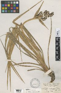 Astelia argyrocoma Heller 87917[1000286]Heller, A.A. 27521895-08-22 United States, Hawaii, Kauai, Island of Kauai, on the Hanapepe and Wahiawa Watershed |
MIN:Plants | 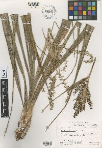 Astelia raiateensis John W. Moore 620516[1000287]Moore, J.W. 1761926-10-07 French Polynesia, Society Islands, Raiatea, Temehani Plain, -16.827646 -151.453148, 450m |
1
Page 1, records 1-4 of 4
Google Map
Google Maps is a web mapping service provided by Google that features a map that users can pan (by dragging the mouse) and zoom (by using the mouse wheel). Collection points are displayed as colored markers that when clicked on, displays the full information for that collection. When multiple species are queried (separated by semi-colons), different colored markers denote each individual species.