University of Minnesota
http://www.umn.edu/
612-625-5000
http://www.umn.edu/
612-625-5000
Minnesota Biodiversity Atlas
Bell Museum
Dataset: MIN-Plants
Taxa: Campanulaceae
Search Criteria: excluding cultivated/captive occurrences
Bell Museum plants | |
 MIN:Plants | Campanula parryi A. Gray 197224[]Eastwood, Alice s.n.1886-06-00 United States, Colorado, [no further data], 2438m |
MIN:Plants | 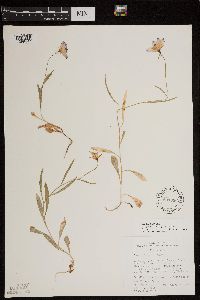 Campanula parryi A. Gray 597096[1299497]Holmgren, Noel; et al. 24211965-08-11 United States, Utah, Garfield, Garfield Co.: Aquarius Plateau, Dixie National Forest, 8 miles north of Escalante where Pine Creek and road meet (Escalante-Loa road). T.34 S, R.2 E, Sec. 12.. 034S 02E 12, 1981m |
MIN:Plants | Campanula parryi A. Gray 197218[]Sheldon, C. s.n.1892-07-05 United States, Colorado, Chaffee, Chaffee Co. ... Buena Vista |
MIN:Plants | Campanula parryi A. Gray 128002[]Nash, A. 43251966-07-30 United States, Wyoming, Park, along Wraith Falls Trail;Yellowstone National Park |
MIN:Plants | Campanula parryi A. Gray 127553[]Nash, A. 43241966-07-30 United States, Wyoming, Park, along Wraith Falls Trail;Yellowstone National Park |
MIN:Plants |  479201[1397359]Husveth, J. 95-17141995-09-04 United States, Minnesota, Goodhue, Goodhue Co, T113N R15W SE1/4 of the NE1/4 of S19; along Cannon River;Dorer Memorial Hardwood State Forest;113N;15W;19, 44.5791086 -92.6620477 |
MIN:Plants | 911733[]Chayka, K. KC-09092009-08-15 United States, Minnesota, Ramsey, Ramsey County...Long Lake Regional Park, New Brighton...west side of railroad tracks across from the train depot;Long Lake County Park;030N;23W;20, 45.0793333 -93.1975 |
MIN:Plants | 304429[]Lakela, Olga 12761935-08-25 United States, Minnesota, Saint Louis, Bank of Lake Superior near the mouth of Congdon Creek (cemetery side) Duluth;;N;;, 46.81471 -92.05204 |
MIN:Plants | 362410[]Moyle, J. 34411940-08-06 United States, Minnesota, Cook, Along road between Tofte and Grand Marais. Cook Co.;Superior National Forest;N;;, 47.678376 -90.595198 |
MIN:Plants | 391779[]Lakela, Olga 61441945-08-19 United States, Minnesota, Saint Louis, On the Old North Shore Road near French River. St. Louis Co.;;051N;12W;, 46.92053 -91.880583 |
MIN:Plants | 463705[]Puchalski, L. 4111993-08-18 United States, Minnesota, Polk, Polk Co.; on south side of road; T 148N R 43W NW1/4 of NE1/4 of Sec 25;;148N;43W;25, 47.607365 -96.078242 |
MIN:Plants |  475479[1397358]Myhre, K. 3351991-07-07 United States, Minnesota, Aitkin, Aitkin County ... 3 miles east of highway 169 on township road 69 (the Mississippi River Road), south side of the road; along the Mississippi River. T 49N R 25W NW1/4 of SW1/4 of Sec 32.. 049N 25W 32, 46.6887667 -93.5373678 |
MIN:Plants |  508527[1397360]Evans, Karen 41751993-07-19 United States, Minnesota, Pine, Pine Co. Located 6 mi NE of the town of Bruno; T44N R17W SE1/4 of SE1/4 of Sec 7;;044N;17W;7, 46.309418 -92.541551 |
MIN:Plants | 558546[]Moore, John 235901957-09-23 United States, Minnesota, Clay, Clay Co.; at Barnesville;;N;;, 46.652182 -96.41979 |
MIN:Plants | 573956[]Stevens, O. 25291961-08-23 United States, Minnesota, Clay, Moorhead, Clay Co.;;139N;48W;, 46.8456476 -96.7288463 |
MIN:Plants | 592029[]Moore, John 267611965-08-05 United States, Minnesota, Anoka, Anoka Co. Growing in the john Mickelson farm yard along the S side of the house, Cedar Creek Natural History Area.;Cedar Creek National History Area;034N;23W;, 45.4280632 -93.2039968 |
MIN:Plants | 592474[]Westkaemper, Remberta s.n.1964-07-00 United States, Minnesota, Stearns, Stearns Co. St. Cloud. St. Cloud Hospital river bank;;N;;, 45.55918 -94.16039 |
MIN:Plants | 616400[]Moore, John; et al. 3911969-07-31 United States, Minnesota, Crow Wing, Crow Wing Natural History Area. Crow Wing County...Growing at house site, S half of the SE1/4, Sec.29, Garrison Twp.;Crow Wing Natural Area;044N;28W;29, 46.2651419 -93.9044982 |
MIN:Plants |  657155[1397356]Scanlan, M. 0801973-08-07 United States, Minnesota, Swift, Swift Co. Collected in SW-257 (Sec.20, T122N, R37W) a 4-acre woodlot;;122N;37W;20, 45.361789 -95.347777 |
MIN:Plants | 670583[]Heitlinger, M. 2061971-07-07 United States, Minnesota, McLeod, Mcleod Co, Schaefer Prairie. SE1/4 of Sec 34, t115N, R29W; just SE of parking space on N side of prairie;Schaefer Prairie, The Nature Conservancy;115N;29W;34, 44.72505 -94.30491 |
MIN:Plants | 685084[]Stassen, Carol 1481977-06-25 United States, Minnesota, Lyon, Camden State Park. Lyon Co. Camden State Park, T111N R42W Sec 32 SE1/4. Old homestead behind original park manager's house, N of horse and Lyon Co. Camden State Park, T111N R42W Sec 32 SE1/4. Old homestead behind original park manager's house, N of horse and snowmobile trail. 111N 42W 32, 44.377898 -95.927589 |
MIN:Plants |  687545[1397355]Wheeler, Gerald; Glaser, Paul 19871977-07-09 United States, Minnesota, Itasca, Itasca Co. Coll. Site #101. E1/2 NE1/4 Sec.32 T56N R25W, approx. 3.5 mi N of Grand Rapids; adjacent to Hwy.38;;056N;25W;32, 47.289571 -93.544201 |
MIN:Plants | 697749[]Ownbey, Gerald 53241976-08-20 United States, Minnesota, Clearwater, Clearwater Co. Itasca State Park. Mississippi Headwaters. In old parking lot, E side;Itasca State Park;144N;36W;, 47.2823239 -95.2334173 |
MIN:Plants | 727894[]Eikum, B. 1481979-07-26 United States, Minnesota, Dakota, Hastings;Hastings Scientific Natural Area;115N;17W;, 44.73907 -92.86266 |
MIN:Plants | 728969[]Berlin, N. 1241979-07-23 United States, Minnesota, Goodhue, Goodhue Co. Wacouta Pond Natural Area: 5 mi SE of Red Wing. Portions of: Sec.6, T112N, R13W and Sec.31,32, T113N, R13W;Wacouta Pond Natural Area, The Nature Conservancy;N;;, 44.514886 -92.465075 |
MIN:Plants |  833144[1397361]Myhre, K. 28191992-07-23 United States, Minnesota, Cass, Cass Co. Located 1 mi S of Leech Lake; T141N R29W NE1/4 of NE1/4 of Sec.17;Chippewa National Forest / Leech Lake Indian Reservation;141N;29W;17, 47.0296351 -94.3753169 |
MIN:Plants |  839355[1397362]Cholewa, A.; Engels, A. 23691995-07-27 United States, Minnesota, Aitkin, Savanna Portage State Park. Aitkin Co. Savanna Portage State Park, about 17 mi NE of McGregor, small manmade opening along ridge on W side of Wolf L Aitkin Co. Savanna Portage State Park, about 17 mi NE of McGregor, small manmade opening along ridge on W side of Wolf Lake, T50N R22W S6 SW1/4 of NE1/4.. 050N 22W 6, 46.845996 -93.1774497 |
MIN:Plants | 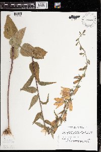 840689[1397357]Myhre, K. 42661993-07-23 United States, Minnesota, Pine, Pine Co. Located 5.5 mi SE of the town of Nickerson; T45N R16W SW1/4 of NW1/4 of Sec 29;Nemadji State Forest;045N;16W;29, 46.352316 -92.394696 |
MIN:Plants | 498936[]Whitfeld, T.J.S. 3532002-07-03 United States, Minnesota, Pope, Pope County ... 3/4 mile west of Starbuck; 1/4 mile north of County Hwy 28 ... T125N R39W SWSW 23;;125N;39W;23, 45.621698 -95.541447 |
MIN:Plants | 440578[]Anonymous s.n.1979-10-14 United States, Minnesota, Hennepin, [no further data];;;;, 45 -93.47 |
MIN:Plants | 493084[]Gerdes, Lynden 49352004-08-26 United States, Minnesota, Lake, Superior National Forest. T61N R07W S30SWNES Lake County ... Superior National forest. Approximately 9.29 miles NNE of Isabella, MN and 0.27 miles SW of Section 29 Lake. Gravel pit on west side of old RR grade.. 061N 07W 30, 47.737919 -91.267161 |
MIN:Plants | 499268[]Juhnke, C. 423 CMJ FRO1999-07-04 United States, Minnesota, Goodhue, Frontenac State Park. Frontenac State Park Goodhue County ... On to bluff edge where the middle bluff trail drops to the Mississippi River from the walk-in campsite ... T112N R13W NE SE SW 2. 112N 13W 2, 44.5350723 -92.3391578 |
MIN:Plants | 937675[]Gerdes, Lynden B. 66352012-07-24 United States, Minnesota, Lake, Approximately 5.70 miles northwest of Isabella, MN. Old location of the Environmental Learning Center in vicinity of staff trailer locations.;Superior National Forest;060N;09W;27, 47.656111 -91.460278 |
MIN:Plants | 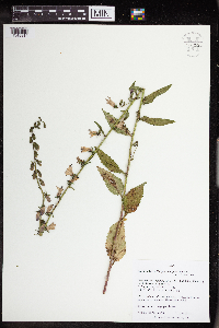 963530[1348914]Nee, M. H. 643002018-06-28 United States, Wisconsin, Grant, 0.5 km. SE of Millville. SW-facing roadside bank along Hwy. C, 43.2475 -90.255, 212m |
MIN:Plants | []Timothy J. S. Whitfeld 37282023-07-18 United States, Minnesota, Washington, Crystal Spring Scientific and Natural Area; 0.4 miles northeast of the intersection of Scandia Trail North and Hwy 95, 45.258155 -92.764969, 271m |
MIN:Plants | Downingia pulchella (Lindley) Torrey 478522[]Univ. of Calif. Bot. Gard. list 17 - 71974-00-00 United States, California, Contra Costa, Contra Costa Co. |
MIN:Plants | Clermontia kakeana Meyen 440579[]US Nat. Arboretum staff s.n.1981-00-00 United States, Hawaii, Oahu, Mt. Tantalus, Honolulu |
MIN:Plants | Campanula angustiflora Eastwood 197157[]Michener; Bioletti 14161892-06-01 United States, California, Marin, Marin County |
MIN:Plants | Campanula angustiflora Eastwood 197159[]Michener; Bioletti s.n.1892-06-01 United States, California, Marin, Marin County ... [Mt.] Tamalpais |
MIN:Plants | Nemacladus ramosissimus Nuttall 499150[]Went, F. s.n.1941-05-00 United States, California, Contra Costa, Moraga Valley, Contra Costa Co. |
MIN:Plants | 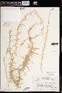 Triodanis leptocarpa (Nuttall) Nieuwland 412167[1397373]Moore, John; Moore, Marjorie 102011938-06-26 United States, Minnesota, Dakota, 1/4 mi W of Fifth Avenue and just S of Church Street, South St. Paul, Dakota Co.;;028N;22W;00, 44.9052257 -93.0450747 |
MIN:Plants | 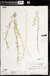 Triodanis leptocarpa (Nuttall) Nieuwland 412198[1397374]Moore, John; Moore, Marjorie 107601939-06-25 United States, Minnesota, Dakota, Dakota County...1/4 mi W of Fifth Avenue and just S of Church Street, South St. Paul;;028N;22W;00, 44.9052257 -93.0450747 |
MIN:Plants |  Campanula carpatica N.J. von Jacquin 197123[1404882]Vagner 2993 Hungary, Comittus Marmaros ... prope Trebusan |
MIN:Plants |  Campanula carpatica N.J. von Jacquin 284157[1404881]Vagner, L. s.n.1889-06-19 Hungary, in alpe Marmaros, ad rupes versus Trebusan |
MIN:Plants | Platycodon grandiflorum (Jacquin) A. de Candolle 367030[]Moore, John; Moore, Marjorie 102821938-08-09 United States, Minnesota, Minnesota; East River Road, south of Franklin Avenue Bridge, Minneapolis, Hennepin County;;029N;23W;, 44.9920769 -93.1663869 |
MIN:Plants |  515272[1397352]Schimpf, D. DJS3682004-07-16 United States, Minnesota, Saint Louis, St. Louis County, Rice Lake Township. T51N R14W SE1/4 of SE1/4 Sec 25...Site of former agricultural research station.;;051N;14W;25, 46.8672218 -92.0491638 |
MIN:Plants | 491273[]Winter, Catherine CW012003-08-06 United States, Minnesota, Saint Louis, St. Louis County, Duluth. T50N R13W NW1/4 Sec 6;;050N;13W;06, 46.8486099 -92.0391693 |
MIN:Plants |  438091[1397347]Pomroy, Deborah; et al. DLP22572005-07-15 United States, Minnesota, Lake, North Shore. Lake County ... T52N R11W NW1/4 of NW1/4 Sec 15 ... 1/2 SW of Two Harbors between Scenic Drive & railroad tracks; 1/2 mi NE of sign to Bob's Cabins ... UTM zone 15T, 596691E, 5205294N (NAD83)[Duplicate of DLP2256]. 052N 11W 15, 46.993423 -91.725972, 210m |
MIN:Plants |  476863[1397350]Gerdes, Lynden 44272001-08-01 United States, Minnesota, Lake, T56N R08W S03SENW. Lake County ... Silver Bay, MN. Tettegouche LSA. Along the North Shore snowmobile trail, approx. 2.0 miles NW of Lax Lake.. 056N 08W 3, 47.364822 -91.335689 |
MIN:Plants | 914155[]Schimpf, D. DJS5612009-07-23 United States, Minnesota, Saint Louis, St. Louis County, Duluth. T50N R14W SW1/4 Sec 8;;050N;14W;08, 46.8272222 -92.1522222 |
MIN:Plants | 380132[]Lakela, Olga 54161943-08-18 United States, Minnesota, Saint Louis, Highway 61, less than 1 mi southeast of the Duluth Water Works, Duluth;;;;, 46.80951 -92.0606 |
MIN:Plants | 391965[]Lakela, Olga 65231946-07-21 United States, Minnesota, Saint Louis, Highway 61, just beyond the Duluth Water Works, Duluth;;;;, 46.80951 -92.0606 |
MIN:Plants | 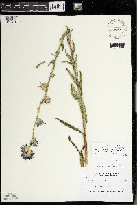 456301[1404879]Marshall, David 970723011997-07-23 United States, Minnesota, Saint Louis, Fond du Lac Indian Reservation. St Louis County ... Along County Road 31 south of Hwy. 2. About 1 mi. W. of the St. Louis River. T 50N R 18W NW1/4 of NW1/4 of Sec 2. 050N 18W 2, 46.846344 -92.586507 |
MIN:Plants | 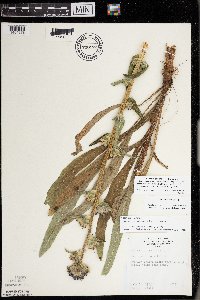 738172[1404878]Monson, Paul 45191963-07-11 United States, Minnesota, Saint Louis, St. Louis Co, Duluth ... road through Hartly tract near pond;;;;, 46.783273 -92.106579 |
MIN:Plants | 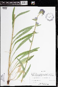 437960[1397348]Pomroy, Deborah DLP20162004-08-02 United States, Minnesota, Saint Louis, St. Louis County, Lakewood Township.T51NR13W SW1/4 of NW1/4 Sec 35. Old Hwy 61 & Lakewood Rd, near water treatment plant.. 051N 13W 35, 46.863666 -91.959917 |
MIN:Plants | 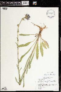 509939[1397349]Gerdes, Lynden 43862001-07-10 United States, Minnesota, Lake, T56N R08W S03SENW. Lake County ... Silver Bay, MN. Tettegouche LSA. Along the North Shore snowmobile trail, approximately 2.0 miles NW of Lax Lake.. 056N 08W 3, 47.364822 -91.335689 |
MIN:Plants | 515304[]Schimpf, D. DJS3742004-08-01 United States, Minnesota, Saint Louis, St. Louis County, Duluth. T50N R13W SE1/4 Sec 4...landward side of Brighton Beach Road.;;050N;13W;04, 46.8424988 -91.9944458 |
MIN:Plants | 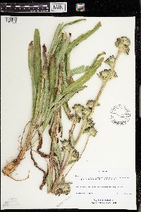 487907[1397351]Schimpf, D. DJS3832004-08-21 United States, Minnesota, Saint Louis, St. Louis County, Cloquet Valley State Forest. T54N R14W SW1/4 Sec 27...Along County Rd. 4, about 1.2 mi N of Co. Rd 49;Cloquet Valley State Forest;054N;14W;27, 47.1261101 -92.1038895 |
MIN:Plants | 944045[]Schimpf, David J. DJS8232015-07-12 United States, Minnesota, Saint Louis, T49N R15W NE1/4 Sec 1, Open right-of-way on SE side of power line, 46.759722 -92.179444 |
MIN:Plants | Nemacladus longiflorus A. Gray 499154[]Went, F. s.n.1941-05-00 United States, California, Contra Costa, Moraga Valley, Contra Costa Co. |
MIN:Plants | Downingia laeta (Greene) Greene 440580[]Bright, R. 73-1561973-00-00 United States, Idaho, Bannock, [no further data] |
MIN:Plants |  914154[1397353]Schimpf, D. DJS5422009-07-08 United States, Minnesota, Saint Louis, St. Louis County, Duluth. T50N R14W NE1/4 Sec 14...above 8th St. & SW of 26th Ave. E.;;050N;14W;14, 46.8169444 -92.0747222 |
MIN:Plants |  914161[1397354]Schimpf, D. DJS5542009-07-15 United States, Minnesota, Saint Louis, St. Louis County, Duluth. T50N R14W Sec 15...between woods and parking lot of nursing home.;;050N;14W;15, 46.8136111 -92.0916667 |
MIN:Plants |  972670[1398223]Blytt s.n. Norway |
MIN:Plants | 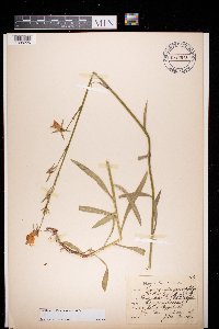 972673[1398226]Julius Persson 7671928-08-02 Sweden, Jonkoping, Kalset Skeppshult |
MIN:Plants | 197064[]G. & L. s.n.1885-08-02 United States, Minnesota, Chippewa, Montevideo;;117N;40W;, 44.93463 -95.67577 |
MIN:Plants | 263902[]Holzinger, John s.n.1901-08-00 United States, Minnesota, Winona, Minn. City; in Winona County;;107N;08;, 44.063412 -91.779624 |
MIN:Plants | 728678[]Lustig, K. 8121979-08-08 United States, Minnesota, Sherburne, Mississippi River Islands Scientific Natural Area. Sherburne & Wright Cos. ...Mississippi Scenic and Recreational River Islands SNA. Mississippi River Islands between Monticello and Elk River. Sec. 2, 3, 4, T 32N, R 26, 27W, Sec. 7, 9, 18, T 121N, R 23, 24W.. 032N 26W 3, 45.295844 -93.666101 |
MIN:Plants | 723640[]Smith, Welby 31111980-08-01 United States, Minnesota, Wright, Wright Co.; T 119N R 24W, SE1/4 SE1/4 sec. 20. Between the Crow River and County Road 19, about 1/2 mile northeast of its junction with State Highway 55 in Rockford.. 119N 24W 20, 45.096081 -93.728422 |
MIN:Plants | 896504[]Smith, Welby 157881989-07-18 United States, Minnesota, Freeborn, Bear Lake Wildlife Management Area. Freeborn County...At the public access on the north side of Bear Lake, about 4 miles north of Emmons...SW1/4 SE1/4 section 8, T 101N R 22W. 101N 22W 8, 43.564613 -93.4980929 |
MIN:Plants | 723820[]Smith, Welby 32491980-08-10 United States, Minnesota, Wright, Wright Co.; T 120N R 23W, NW1/4 NW1/4 section 18. About 2 miles east of St. Michael; west bank of the Crow River.;;120N;23W;18, 45.201296 -93.635461 |
MIN:Plants | 461607[]Husveth, J. 95-37381995-09-12 United States, Minnesota, Winona, Winona Co, T107n r10W SW1/4 of the SE1/4 of S6; North Fork of the Whitewater River.;Whitewater Wildlife Management Area;107N;10W;6, 44.09954 -92.069429 |
MIN:Plants | 197059[]Sheldon, Edmund S11631891-07-00 United States, Minnesota, Brown, New Ulm.;;110N;30W;, 44.3263589 -94.431802 |
MIN:Plants | 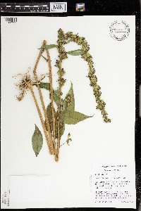 428501[1397333]Husveth, J. 95-31451995-08-30 United States, Minnesota, Wabasha, Wabasha Co, T110N R12W SW1/4 of the NE1/4 of S36; Zumbro River.;Dorer Memorial Hardwood State Forest;110N;12W;36, 44.287627 -92.199704 |
MIN:Plants |  480764[1397334]Bosch, T. 232002-07-25 United States, Minnesota, Big Stone, Lac Qui Parle Wildlife Management Area. Big Stone County ... Lac Qui Parle Wildlife Area ... Approx. 0.5 east of Hwy. 75 and 2 miles south of Hwy. 7 ... T120N R45W sec. 1-2. 120N 45W 42371, 45.1967547 -96.2899963 |
MIN:Plants | 727881[]Eikum, B. 1531979-08-14 United States, Minnesota, Dakota, Dakota County...Hastings Scientific and Natural Area: Hastings, sec. 23, 34, 35, T 115N, R 17W.;Hastings Scientific Natural Area;115N;17W;00, 44.7390747 -92.8626554 |
MIN:Plants | 197072[]Sandberg, John s.n.1881-07-00 United States, Minnesota, Goodhue, Cannon Falls;;112N;17W;18, 44.50707 -92.90512 |
MIN:Plants | 197070[]Sheldon, Edmund S10961891-07-00 United States, Minnesota, Brown, Springfield;;109N;34W;, 44.2387535 -94.9269277 |
MIN:Plants |  477365[1397327]Smith, Welby 174011990-07-23 United States, Minnesota, Steele, Steele County ... Kaplan Woods City Park, on the south side of Owatonna ... north side of Straight River ... T107N R20W NE1/4 of NW1/4 of Sec 21. 107N 20W 21, 44.0644455 -93.2350006 |
MIN:Plants | 197069[]Ballard, C. B6141891-07-00 United States, Minnesota, Carver, Chaska.;;116N;23W;, 44.848169 -93.5810628 |
MIN:Plants | 454890[]Bosch, T. 282002-07-25 United States, Minnesota, Big Stone, Big Stone County ... Approx. 0.5 east of Hwy. 75 and 2 miles south of Hwy. 7 ... T120N R45W sec. 1-2;Lac Qui Parle Wildlife Management Area;120N;45W;1-2, 45.2325 -96.23654 |
MIN:Plants | 197060[]Sheldon, Edmund S7881891-07-00 United States, Minnesota, Brown, Sleepy Eye;;110N;32W;, 44.3258855 -94.6847583 |
MIN:Plants | 672662[]Wheeler, Gerald 8791976-08-02 United States, Minnesota, Winona, Winona Co.; Approx. 5 miles south of the John A. Latsch State Park on Highway 61;Dorer Memorial Hardwood State Forest;108N;08W;, 44.131005 -91.791254 |
MIN:Plants | 770171[]Smith, Welby 87481983-08-28 United States, Minnesota, Jackson, Kilen Woods State Park. Jackson Co.; Kilen Woods State Park, about 8 miles north-northwest of Jackson; in the Des Moines River Valley. SW1/4 NE1/4 section 17, T 103N R 35W. 103N 35W 17, 43.724814 -95.064648 |
MIN:Plants | 747007[]Galatowitsch, S. 5121982-07-16 United States, Minnesota, Goodhue, Goodhue Co.; Grace Nature Preserve: T109N R18W parts of NW1/4 SW1/4 and SW1/4 SW1/4 of Sec. 8;Grace Nature Preserve, The Nature Conservancy;109N;18W;8, 44.2620117 -93.0105438 |
MIN:Plants |  511611[1397335]Wheeler, Gerald 201461999-07-31 United States, Minnesota, Carver, Carver County ... Ca. 0.5 mi. SSW of East Union on Rte. 40, W of raod ... Overlooking Bevens Creek ... NE1/4 SW 1/4 Sec. 3 T114N R2W (San Francisco 3). 114N 24W 3, 44.71137 -93.68529 |
MIN:Plants | 197062[]Sandberg, John s.n.1890-07-00 United States, Minnesota, Hennepin, [no further data];;;;, 45 -93.47 |
MIN:Plants | 125969[]Marlett, J. s.n.1955-08-06 United States, Minnesota, Dakota, Dakota Co.; Five miles south of Minneapolis (approx.). Five hundred yards southwest of the bridge on which Highway 65 crosses the Minnesota River [prob. means hwy 55; hwy 65 doesn't extend this far south]. Behind abandoned buildings. 028N 23W, 44.881205 -93.17047 |
MIN:Plants | 453928[]Wheeler, Gerald 171451997-08-11 United States, Minnesota, Chippewa, Chippewa County ... Ca. 3 mi. SE of Granite Falls, SW of Pete's Pt. Rd. SE ... SW1/4 SW1/4 NE1/4 Sec. 13 T115N R39W;Gneiss Outcrops Scientific Natural Area;115N;39W;13, 44.7649946 -95.4975644 |
MIN:Plants | 197073[]Wert, C. s.n.1907-09-00 United States, Minnesota, Hennepin, Minnehaha;Minnehaha Falls Park;028N;23W;, 44.9051624 -93.1664625 |
MIN:Plants |  509408[1397331]Wheeler, Gerald 205001999-09-09 United States, Minnesota, Nicollet, Nicollet County ... Ca. 2.3 mi W of Nicollet on Rte. 14, N of road; Swan Lake WMA ... N1/2 Sec. 6 T109N R28W;Swan Lake Wildlife Management Area;109N;28W;6, 44.275753 -94.240942 |
MIN:Plants | 558336[]Moore, John 234681957-08-09 United States, Minnesota, Waseca, Waseca Co.; along the east shore of Lake Elysian;;108N;24W;, 44.152568 -93.70784 |
MIN:Plants | 764631[]Ballard, C. s.n.1892-08-00 United States, Minnesota, Nicollet, Courtland, Nicollet Co.;;109N;29W;, 44.239382 -94.311376 |
MIN:Plants | 554448[]Moore, John; Hsi, Yu-tseng [Eugene] 233421957-08-06 United States, Minnesota, Blue Earth, 1 mi. W of Mankato;;N;;, 44.163576 -94.01959 |
MIN:Plants | 681708[]Gustitus, J. 791973-10-10 United States, Minnesota, Ramsey, Ramsey Co. Univ. of Minn, St. Paul campus. In alley near campus;;029N;23W;, 44.992077 -93.166387 |
MIN:Plants | 697827[]Ownbey, Gerald; et al. 53311976-08-26 United States, Minnesota, Houston, Houston Co. Rt. 26, 1.3 mi. N of Iowa border at New Albin;Dorer Memorial Hardwood State Forest;101N;04W;, 43.5438967 -91.3125642 |
MIN:Plants | 782248[]Ownbey, Gerald 70631986-07-20 United States, Minnesota, Washington, Afton State Park, T28N, R20W, Sec. 34, SW1/4 of the SW1/4. Along Trout Brook adjacent to Rte. 21.;Afton State Park;028N;20W;34, 44.869168 -92.791591 |
MIN:Plants | 782383[]Tenney, M. 4371982-07-15 United States, Minnesota, Fillmore, Forestville State Park. Fillmore Co. T102N, R12W, Sec. 13, SW1/4 NE1/4 SE1/4.;Forestville State Park;102N;12W;13, 43.6377242 -92.2192693 |
MIN:Plants |  782391[1397330]Tenney, M. 4941982-07-29 United States, Minnesota, Fillmore, Forestville State Park. Fillmore Co. T102N, R12W, Sec. 13, SW1/4 NW1/4 NE1/4.;Forestville State Park;102N;12W;13, 43.6377242 -92.2192693 |
MIN:Plants |  782681[1397328]Tenney, M. 4621982-07-19 United States, Minnesota, Winona, Whitewater State Park. T107N, R10W, Sec. 20, NE1/4 NE1/4 NW1/4 SW1/4;Whitewater State Park;107N;10W;20, 44.056501 -92.049518 |
Google Map
Google Maps is a web mapping service provided by Google that features a map that users can pan (by dragging the mouse) and zoom (by using the mouse wheel). Collection points are displayed as colored markers that when clicked on, displays the full information for that collection. When multiple species are queried (separated by semi-colons), different colored markers denote each individual species.