University of Minnesota
http://www.umn.edu/
612-625-5000
http://www.umn.edu/
612-625-5000
Minnesota Biodiversity Atlas
Bell Museum
Dataset: MIN-Plants
Taxa: Celastraceae
Search Criteria: excluding cultivated/captive occurrences
Bell Museum plants | |
 MIN:Plants | 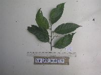 951760[1297942]Weiblen, G.D. YP2D00792012-07-28 Papua New Guinea, Morobe, Yawan Village, -6.1642 146.840083, 1738m |
MIN:Plants | 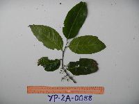 951761[1297941]Weiblen, G.D. YP2A00882010-10-11 Papua New Guinea, Morobe, Yawan Village, -6.162617 146.841967, 1777m |
MIN:Plants | 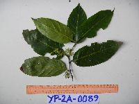 951763[1297940]Weiblen, G.D. YP2A00892010-10-09 Papua New Guinea, Morobe, Yawan Village, -6.162617 146.841967, 1777m |
MIN:Plants |  951769[1297935]Weiblen, G.D. YP1B00172012-06-04 Papua New Guinea, Morobe, Yawan Village, -6.1637 146.842017, 1749m |
MIN:Plants | 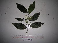 951773[1297933]Weiblen, G.D. YP1D00252012-05-17 Papua New Guinea, Morobe, Yawan Village, -6.1642 146.840083, 1738m |
MIN:Plants | 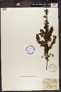 150366[1374882]Wood, J. Medley 11391880-11-00 South Africa, Mount Edgecombe, 122m |
MIN:Plants | Parnassia NULL 307094[]Jones, Marcus E. s.n.1910-08-09 United States, Montana, Glacier National Park. Mineral Park., 1829m |
MIN:Plants | Parnassia NULL 827902[]Kohls, Steve s.n.1991-07-01 United States, Alaska, Glacier Bay National Park, north shoreline of head of Wachusett Inlet., 58.797428 -136.838127 |
MIN:Plants | Parnassia glauca Rafinesque 498933[]Whitfeld, T.J.S. 3662002-08-01 United States, Minnesota, Kandiyohi, Kandiyohi County ... 11 miles east of Willmar; 1 mile east of County Rd 4; 1/4 mile north of County Rd 23 ... T119N R33W SENESE21. 119N 33W 21, 45.121685 -94.817591 |
MIN:Plants | Parnassia glauca Rafinesque 508094[]Lee, Michael MDL22821998-07-24 United States, Minnesota, Stearns, Stearns Co. ... along County Road 137 in Waite Park ... T124N R28W NW1/4 of NW1/4 Sec. 30;;124N;28W;30, 45.521972 -94.260178 |
MIN:Plants | Parnassia glauca Rafinesque 539968[]Tester, John s.n.1957-08-12 United States, Minnesota, Mahnomen, 3-4 miles W and 1 mile S of Waubun;Waubun Prairie Wildlife Management Area / White Earth Indian Reservation;143N;42W;33, 47.1589 -96.00743 |
MIN:Plants | Parnassia glauca Rafinesque 914836[]Smith, Welby 226701993-07-01 United States, Minnesota, Otter Tail, Otter Tail County ... On the north side of CSAH 38; 0.8 mile east of its junction with TH 78, and about 11 miles south of Battle Lake (town) ... T131N R40W SE1/4 of SE1/4 of Sec 22. 131N 40W 22, 46.1380556 -95.6908333 |
MIN:Plants | Parnassia glauca Rafinesque 430206[]Lee, Michael MDL19311997-09-04 United States, Minnesota, Stearns, Stearns Co.; Along Hwy 23 at Kolling Creek two miles east of Roscoe; T123N R31W NW1/4 of NW1/4 Sec. 28;;123N;31W;28, 45.438795 -94.588156 |
MIN:Plants | Parnassia glauca Rafinesque 477377[]Smith, Welby 171621990-07-11 United States, Minnesota, Dodge, Wasioja Wildlife Management Area. Dodge County ... In Wasioja State Wildlife Management Area, about 4 miles west of Wasioja ... T107 N R17W SE1/4 of SW1/4 of Sec 17. 107N 17W 17, 44.0672226 -92.8916702 |
MIN:Plants | Parnassia glauca Rafinesque 454290[]Biederman, L. 3071999-07-25 United States, Minnesota, Pipestone, Pipestone County ... in the northeast corner of Altona Wildlife Management Area ... T108N R46W NENW01;Altona Wildlife Management Area;T108N R46W S01, 44.190127 -96.318183 |
MIN:Plants | Parnassia glauca Rafinesque 123445[]Ballard, C. 31261901-08-14 United States, Minnesota, Clay, Muskoda [historic RR station near Hawley], Red R. Val.;;139N;45W;17, 46.854778 -96.396816 |
MIN:Plants | Parnassia glauca Rafinesque 123452[]Anonymous s.n. United States, Minnesota, [no further data];;;;, 46 -94 |
MIN:Plants | Parnassia glauca Rafinesque 123453[]Illegible name 1071900-08-18 United States, Minnesota, [no further data];;;;, 46 -94 |
MIN:Plants | Parnassia glauca Rafinesque 478238[]Lee, Michael MDL22211998-07-02 United States, Minnesota, Stearns, Stearns County ... On west side of County Road 10 one mile north of Roscoe ... T123N R32W S1/2 of NE1/4 of SE1/4 Sec. 24;;123N;32W;24, 45.433611 -94.640278 |
MIN:Plants | Parnassia glauca Rafinesque 123458[]Manning, Sara s.n.1884-08-23 United States, Minnesota, Wabasha, Lake City;;N;;, 44.449412 -92.266844 |
MIN:Plants | Parnassia glauca Rafinesque 123459[]Moyer, Lycurgus 18521897-08-25 United States, Minnesota, Pope, Lake Minnewaska;;N;;, 45.617836 -95.450645 |
MIN:Plants | Parnassia glauca Rafinesque 123460[]Aiton, G. s.n.1889-08-00 United States, Minnesota, Hennepin, [no further data];;;;, 45 -93.47 |
MIN:Plants | Parnassia glauca Rafinesque 123461[]Aiton, G. s.n.1891-04-00 United States, Minnesota, Hennepin, near Minneapolis;;N;;, 44.963488 -93.258331 |
MIN:Plants | Parnassia glauca Rafinesque 123462[]Sandberg, John s.n.1890-08-00 United States, Minnesota, Hennepin, [no further data];;;;, 45 -93.47 |
MIN:Plants | Parnassia glauca Rafinesque 123464[]Oestlund, O. s.n.1886-08-00 United States, Minnesota, Hennepin, Minneapolis;;N;;, 44.979965 -93.263836 |
MIN:Plants | Parnassia glauca Rafinesque 123465[]Herrick, C. s.n.1878-07-00 United States, Minnesota, Hennepin, Minneapolis;;N;;, 44.979965 -93.263836 |
MIN:Plants | Parnassia glauca Rafinesque 123466[]Ballard, C. B11591892-08-00 United States, Minnesota, Goodhue, Forest Mills;;N;;, 44.289142 -92.641089 |
MIN:Plants | Parnassia glauca Rafinesque 123467[]Ballard, C. B6191891-07-00 United States, Minnesota, Scott, Shakopee, Scott Co.;;115N;22W;, 44.798019 -93.526899 |
MIN:Plants | Parnassia glauca Rafinesque 123468[]Holzinger, John s.n.1886-08-00 United States, Minnesota, Winona, Winona Co.;;N;;, 43.98685 -91.779129 |
MIN:Plants | Parnassia glauca Rafinesque 123469[]MacMillan, C.; et al. 94sk1900-08-00 United States, Minnesota, Polk, Crookston;;150N;46W;30, 47.782 -96.60007 |
MIN:Plants | Parnassia glauca Rafinesque 123470[]Wheeler, William 6291899-08-25 United States, Minnesota, Houston, Brownsville, Houston Co.;;103N;04W;, 43.694136 -91.279857 |
MIN:Plants | Parnassia glauca Rafinesque 123472[]Taylor, B. T10111891-08-00 United States, Minnesota, Pope, Glenwood;;N;;, 45.648982 -95.401248 |
MIN:Plants | Parnassia glauca Rafinesque 123473[]Wheeler, William 5871899-08-21 United States, Minnesota, Houston, Crooked Creek, Houston Co.;Dorer Memorial Hardwood State Forest;N;;, 43.592621 -91.284352 |
MIN:Plants | Parnassia glauca Rafinesque 123474[]Sheldon, Edmund S35401892-07-00 United States, Minnesota, Otter Tail, Lake Belmont;;N;;, 46.197922 -95.64198 |
MIN:Plants | Parnassia glauca Rafinesque 123475[]Burglehaus, F. s.n.1892-09-00 United States, Minnesota, Hennepin, Minneapolis;;N;;, 44.979965 -93.263836 |
MIN:Plants | Parnassia glauca Rafinesque 229006[]Rosendahl, C. s.n.1924-09-19 United States, Minnesota, Scott, near Savage, 3/4 mi W, Minn River Valley;;N;;, 44.774013 -93.368608 |
MIN:Plants | Parnassia glauca Rafinesque 264092[]Holzinger, John s.n.1905-09-00 United States, Minnesota, Winona, S shore of L. Winona, Winona Co.;;107N;07W;, 44.052587 -91.6726869 |
MIN:Plants | Parnassia glauca Rafinesque 264093[]Holzinger, John s.n.1909-08-00 United States, Minnesota, Winona, S shore of L. Winona, Winona Co.;;107N;07W;, 44.052587 -91.6726869 |
MIN:Plants | Parnassia glauca Rafinesque 264094[]Holzinger, John s.n.1897-07-00 United States, Minnesota, Winona, Winona Co.;;N;;, 43.98685 -91.779129 |
MIN:Plants | Parnassia glauca Rafinesque 278123[]Roberts, Thomas s.n.1887-08-00 United States, Minnesota, Hennepin, Minneapolis;;N;;, 44.979965 -93.263836 |
MIN:Plants | Parnassia glauca Rafinesque 373847[]Moore, John; et al. 151241941-09-19 United States, Minnesota, Dakota, Dakota County...1/2 mi S of Nicols;;027N;23W;19, 44.812024 -93.217752 |
MIN:Plants | Parnassia glauca Rafinesque 393513[]Stevens, O. s.n.1947-08-18 United States, Minnesota, Clay, [no further data];Buffalo River State Park;139N;46W;10, 46.863699 -96.472855 |
MIN:Plants | Parnassia glauca Rafinesque 436451[]Smith, Welby 148041988-08-09 United States, Minnesota, Nobles, Nobles County...About 2 miles west-northwest of Adrian. On the right-of-way of the C&NW Railroad. SW1/4 SW1/4 section 11, T 102N R 43W. 102N 43W 11, 43.6458333 -95.9694444 |
MIN:Plants | Parnassia glauca Rafinesque 456016[]Smith, Welby 132161987-06-27 United States, Minnesota, Pipestone, Altona Wildlife Management Area. Pipestone County...Altona State Wildlife Management Area, about 1.5 miles southeast of Verdi. NW1/4 NW1/4 section 1, T 108N R 46W. 108N 46W 1, 44.1966667 -96.325 |
MIN:Plants | Parnassia glauca Rafinesque 457226[]Puchalski, L. 3801993-08-10 United States, Minnesota, Polk, Polk Co.; T 150N R 39W NW1/4 of SE1/4 of Sec 22;;150N;39W;22, 47.797388 -95.633726 |
MIN:Plants | Parnassia glauca Rafinesque 460856[]Smith, Welby 148161988-08-09 United States, Minnesota, Pipestone, Burke Wildlife Management Area. Pipestone County ... Burke State Wildlife Management Area, about 3 miles east of Hatfield ... SE1/4 SE1/4 sec.28, T 106N R 44W. 106N 44W 28, 43.9522209 -96.1275024 |
MIN:Plants | Parnassia glauca Rafinesque 494483[]Huff, N. s.n.1941-08-18 United States, Minnesota, Beltrami, Big Bog, Upper Red Lake;Red Lake Indian Reservation;N;;, 48.13107 -94.766637 |
MIN:Plants | Parnassia glauca Rafinesque 506758[]Smith, Welby 169271990-06-20 United States, Minnesota, Dodge, Pheasants Forever Wildlife Management Area. Dodge Co.; 'Pheasants Forever' State Wildlife Management Area, about 2.5 mi W-SW of Mantorville; Dodge Co.; 'Pheasants Forever' State Wildlife Management Area, about 2.5 mi W-SW of Mantorville; T107N R17W SW1/4 of SE1/4 of Sec 24. 107N 17W 24, 44.0530548 -92.9300003 |
MIN:Plants | Parnassia glauca Rafinesque 506778[]Smith, Welby 180931990-08-28 United States, Minnesota, Carver, Raquet Wildlife Management Area. Carver County... At base of south-facing bluff in the Minnesota River Valley, about 2 mi northwest of Shakopee T116N R23W NE1/4 of SW1/4 of sec 35. 116N 23W 35, 44.8111111 -93.5575 |
MIN:Plants | Parnassia glauca Rafinesque 518483[]Ostlie, Wayne 1741993-08-24 United States, Minnesota, Chippewa, Watson Sag Fen. NW4, NW4, Sec.6, T118N, R41W, Tunsberg Township, Chippewa County;Lac Qui Parle Wildlife Management Area;118N;41W;6, 45.00968 -95.801418 |
MIN:Plants | Parnassia glauca Rafinesque 518513[]Ostlie, Wayne 1671993-08-24 United States, Minnesota, Chippewa, Kragero Township Fen. SW4, Sec.36, T119N, R42W, Kragero Township, Chippewa County;Lac Qui Parle Wildlife Management Area;119N;42W;36, 45.068819 -95.872453 |
MIN:Plants | Parnassia glauca Rafinesque 519094[]Ostlie, Wayne 1551993-09-12 United States, Minnesota, Chippewa, Lac Qui Parle Wildlife Management Area. Zion Luthern Church Fen. N2, SW4, Sec.6, T118N, R42W, Kragero Township, Chippewa Co. [Kragero Twp is in Chippewa Co, T1 Zion Luthern Church Fen. N2, SW4, Sec.6, T118N, R42W, Kragero Township, Chippewa Co. [Kragero Twp is in Chippewa Co, T118N R42W S6 is in Lac Qui Parle Co.; prob. meant R41W]; bordering Watson Sag etc. 118N 41W 6, 45.05734 -95.8477 |
MIN:Plants | Parnassia glauca Rafinesque 536272[]Aiton, G. s.n.1890-09-00 United States, Minnesota, Hennepin, vicinity of Minneapolis;;N;;, 44.979965 -93.263836 |
MIN:Plants | Parnassia glauca Rafinesque 566677[]Moore, John; Heig, V. 241051958-09-10 United States, Minnesota, Kittson, 3 mi N of Halma;;N;;, 48.704505 -96.600321 |
MIN:Plants | Parnassia glauca Rafinesque 578674[]Ownbey, Gerald; Bloom, W. 34381962-08-22 United States, Minnesota, Clearwater, ca 5.6 mi due N of Clearbrook, Rte 5, T150N, R37W, SE1/4 SE1/4 S30;;150N;37W;30, 47.776823 -95.433011 |
MIN:Plants | Parnassia glauca Rafinesque 607855[]Tuthill, M. s.n.1904-09-06 United States, Minnesota, Winona, near Winona;;N;;, 44.0333 -91.6333 |
MIN:Plants | Parnassia glauca Rafinesque 715299[]Farrell, P. 1181979-07-31 United States, Minnesota, Beltrami, Lake Bemidji Bog SNA: 1 mi NW of Lake Bemidji, N1/2 of NW1/4 of S24, T147N, R33W;;147N;33W;24, 47.536135 -94.815118 |
MIN:Plants | Parnassia glauca Rafinesque 715549[]Keller, C. 1431979-08-09 United States, Minnesota, Beltrami, Pennington Orchid Bog SNA: 1 mi N of Pennington, NW1/4 S3, T146N, R30W;Leech Lake Indian Reservation / Pennington Bog Scientific Natural Area;146N;30W;3, 47.494806 -94.474276 |
MIN:Plants | Parnassia glauca Rafinesque 721478[]Farrell, P. 2311979-08-29 United States, Minnesota, Polk, 7 mi. SE of Crookston. S1/2 of section;Pankratz Memorial Prairie, The Nature Conservancy;149N;45W;08, 47.73852 -96.44879 |
MIN:Plants | Parnassia glauca Rafinesque 723713[]Woolsey, Henry; et al. s.n.1980-08-05 United States, Minnesota, Nicollet, Nicollet Co. Slope of the Minnesota River Valley just S of Fort Ridgley State Park. NW1/4 SE1/4 S6, T111N, R32W.;Fort Ridgely State Park;111N;32W;6, 44.441858 -94.732566 |
MIN:Plants | Parnassia glauca Rafinesque 723715[]Woolsey, Henry; et al. s.n.1980-07-09 United States, Minnesota, Jackson, NW NE NE S7, T103N, R35W. E facing slope of the Des Moines River Valley;;103N;35W;7, 43.739139 -95.08514 |
MIN:Plants | Parnassia glauca Rafinesque 724426[]Smith, Welby 24211980-06-10 United States, Minnesota, Douglas, T129N, R40W, NW1/4 NE1/4 NW1/4 S13; between State Hwy 52 and the Great Northern rr tracks;;129N;40W;13, 45.989354 -95.652593 |
MIN:Plants | Parnassia glauca Rafinesque 724595[]Smith, Welby 34191980-08-20 United States, Minnesota, Jackson, T103N, R35W, SE1/4 SE1/4 NW1/4 S17. Kilen Woods State Park;Kilen Woods State Park;103N;35W;17, 43.72505 -95.064623 |
MIN:Plants | Parnassia glauca Rafinesque 726329[]Smith, Welby 36341980-09-07 United States, Minnesota, Scott, Scott Co. T115N, R21W, SE1/4 NE1/4 S17; ca 1 mi W of downtown Savage, and 1/2 mi S of Hwy 13;Savage Fen Scientific Natural Area;115N;21W;17, 44.769646 -93.362783 |
MIN:Plants | Parnassia glauca Rafinesque 727173[]Herman, J. 1891979-08-29 United States, Minnesota, Norman, Twin Valley Prairie: 5 mi W of Syre, NW1/4 and E1/2 of SW1/4 of S23, T143N, R45W;Twin Valley Prairie Scientific Natural Area;143N;45W;23, 47.187516 -96.353808 |
MIN:Plants | Parnassia glauca Rafinesque 728080[]Farrell, P.; et al. 2851979-08-14 United States, Minnesota, Polk, Pembina Trail Preserve Scientific Natural Area. Polk County...Pembina Trail Preserve...6 1/2 mi E of Harold, all sec 36, frac. sec 25, 30, 31, T149N, R45W, frac. sec. 1, 2, T148N, R45W. , 47.666007 -96.334334 |
MIN:Plants | Parnassia glauca Rafinesque 728111[]Herman, J. 1851979-08-28 United States, Minnesota, Mahnomen, Mahnomen Co. Santee Prairie: 3 mi SE of Bejou S6, 7, T145N, R41W;Santee Prairie Scientific Natural Area / White Earth Indian Reservation;145N;41W;, 47.405144 -95.922514 |
MIN:Plants | Parnassia glauca Rafinesque 728222[]Severson, M. 1371979-08-08 United States, Minnesota, Polk, Pankratz Prairie South: 7 mi SE of Crookston, SE1/4 of S17, NE1/4 of S20, T149N, R45W;Pankratz Memorial Prairie, The Nature Conservancy;149N;45W;, 47.723975 -96.4489 |
MIN:Plants | Parnassia glauca Rafinesque 728347[]Dana, R. s.n.1978-08-16 United States, Minnesota, Jackson, Kilen Woods State Park;Kilen Woods State Park;103N;35W;17, 43.72505 -95.064623 |
MIN:Plants | Parnassia glauca Rafinesque 728847[]Woolsey, Henry; et al. s.n.1980-09-09 United States, Minnesota, Rice, On Cannon River, 2 4 mi SW of Northfield.;Cannon River Wilderness Park;111N;20W;34, 44.457746 -93.160425 |
MIN:Plants | Parnassia glauca Rafinesque 732537[]Petron, T. 4071980-08-28 United States, Minnesota, Becker, Zimmerman Prairie: 10 mi W of Ogema. SE1/4 SW1/4 S16, T142N, R43W;Zimmerman Prairie [TNC];142N;43W;16, 47.111989 -96.14657 |
MIN:Plants | Parnassia glauca Rafinesque 734928[]Petron, T. 4211980-09-02 United States, Minnesota, Clay, Bluestem Prairie: 13 mi E of Moorhead, SE1/4 SE1/4 S22, T139N, R46W;Bluestem Prairie Scientific Natural Area;139N;46W;22, 46.840463 -96.473451 |
MIN:Plants | Parnassia glauca Rafinesque 741271[]Converse, C. 21421982-08-27 United States, Minnesota, Pope, Ordway Prairie: T123N, R36W NE1/4 NW1/4 S30;Ordway Prairie, The Nature Conservancy;123N;36W;30, 45.434262 -95.245019 |
MIN:Plants | Parnassia glauca Rafinesque 744919[]Smith, Welby 51301981-07-31 United States, Minnesota, Norman, on the E side of Co Hwy 40, ca 2 1/2 mi S of Faith. SW1/4 NW14 S25, T144N, R43W;;144N;43W;25, 47.259981 -96.077052 |
MIN:Plants | Parnassia glauca Rafinesque 744924[]Smith, Welby 51901981-08-01 United States, Minnesota, Clay, ca 3 mi ESE of the jnc of State Hwy 9 and Co Hwy 34 in Felton. NE1/4 SE1/4 S36, T142N, R46W;;142N;46W;36, 47.070359 -96.446855 |
MIN:Plants | Parnassia glauca Rafinesque 744985[]Smith, Welby 53321981-08-06 United States, Minnesota, Martin, on the N side of Co Hwy 50, ca 2 1/4 mi W of its jnc with State Hwy 15 in Truman. SW1/4 SE1/4 S7, T104N, R30W;;104N;30W;7, 43.825466 -94.48011 |
MIN:Plants | Parnassia glauca Rafinesque 745026[]Smith, Welby 57731981-09-16 United States, Minnesota, Becker, Becker Co. Spring Creek State Wildlife Management Area, 1 1/4 NNW of Ogema. NE1/4 NE1/4 S13, T142N, R42W;Spring Creek Wildlife Management Area / White Earth Indian Reservation;142N;42W;13, 47.120565 -95.936471 |
MIN:Plants | Parnassia glauca Rafinesque 745051[]Smith, Welby 51661981-07-31 United States, Minnesota, Polk, Polk County...About 3 mi NE of Harold...SW1/4 NE1/4 S17, T149N, R45W;Pankratz Memorial Prairie, The Nature Conservancy;149N;45W;17, 47.723975 -96.4489 |
MIN:Plants | Parnassia glauca Rafinesque 745458[]Smith, Welby 50341981-07-25 United States, Minnesota, Yellow Medicine, Sioux Nationalion Wildlife Management Area. Yellow Medicine County ... Sioux Nationa State Wildlife Management Area. About 8 miles west-southwest of Canby ... NW1/4 SW1/4 section 17, T 114n R 46W. 114N 46W 17, 44.680542 -96.437023 |
MIN:Plants | Parnassia glauca Rafinesque 745464[]Smith, Welby 48301981-07-14 United States, Minnesota, Yellow Medicine, Sioux Nation State Wildlife Management Area, ca 8 mi WSW of Canby. NW1/4 SW1/4 S17, T114N, R46W;Sioux Nationalion Wildlife Management Area;114N;46W;17, 44.680542 -96.437023 |
MIN:Plants | Parnassia glauca Rafinesque 758012[]Smith, Welby 76101982-09-11 United States, Minnesota, Dakota, Dakota Co. Fort Snelling State Park, in the Minnesota River Valley 1/2 mi E of Gun Club Lake. SE1/4 NW1/4 S4, T27N, R23W;Fort Snelling State Park;027N;23W;4, 44.856868 -93.180783 |
MIN:Plants | Parnassia glauca Rafinesque 758179[]Smith, Welby 71311982-08-08 United States, Minnesota, Dakota, Dakota Co. About 1 mi S of Black Dog Lake, in the Minnesota Valley. NW1/4 NE1/4 S34, T27N, R24W;Black Dog Preserve Scientific Natural Area;027N;24W;34, 44.788737 -93.275528 |
MIN:Plants | Parnassia glauca Rafinesque 758252[]Smith, Welby 71021982-08-06 United States, Minnesota, Clearwater, on the E side of Co Hwy 5, ca 2 1/4 mi N of its jnc with State Hwy 92 in Clearbrook. SW1/4 NW1/4 S17, T149N, R37W;;149N;37W;17, 47.724444 -95.420116 |
MIN:Plants | Parnassia glauca Rafinesque 758409[]Smith, Welby 72251982-08-12 United States, Minnesota, Polk, Polk County...on the N side of Co Hwy 45, about 12-1/2 mi ESE of Crookston...SW1/4 SW1/4 S19, T149N, R44W;Pembina Trail Preserve Scientific Natural Area;149N;44W;19, 47.709228 -96.341088 |
MIN:Plants | Parnassia glauca Rafinesque 758527[]Smith, Welby 70761982-08-06 United States, Minnesota, Mahnomen, Mahnomen Co. Waubun State Wildlife Management Area, ca 1 mi S of Waubun (town). NW1/4 SW1/4 S25, T143N, R42W;Waubun Prairie Wildlife Management Area / White Earth Indian Reservation;143N;42W;25, 47.173217 -95.942902 |
MIN:Plants | Parnassia glauca Rafinesque 758604[]Smith, Welby 71851982-08-11 United States, Minnesota, Pope, ca 8 mi SW of Brooten, SE1/4 NW1/4 S30, T123N, R36W;;123N;36W;30, 45.434262 -95.245019 |
MIN:Plants | Parnassia glauca Rafinesque 759058[]Smith, Welby 75781982-09-08 United States, Minnesota, Mower, Cartney Wildlife Management Area. Cartney State Wildlife Management Area, ca 5 mi NNW of Le Roy, adjacent to the West Branch Little Iowa River. NW1/4 NE1/ Cartney State Wildlife Management Area, ca 5 mi NNW of Le Roy, adjacent to the West Branch Little Iowa River. NW1/4 NE1/4 S5, T101N, R14W. 101N 14W 5, 43.580049 -92.539234 |
MIN:Plants | Parnassia glauca Rafinesque 759153[]Smith, Welby 71991982-08-12 United States, Minnesota, Norman, Agassiz-Olson State Wildlife Management Area, ca 12 mi NNE of Ada;Agassiz-Olson Wildlife Management Area;146N;45W;22, 47.448741 -96.37649 |
MIN:Plants | Parnassia glauca Rafinesque 759251[]Smith, Welby 73401982-08-19 United States, Minnesota, Le Sueur, LeSueur Co.; on the W side of Co Hwy 23, about 2 mi NE of St. Peter, in the Minnesota Valley. NE1/4 NW1/4 S11, T110N, R2 LeSueur Co.; on the W side of Co Hwy 23, about 2 mi NE of St. Peter, in the Minnesota Valley. NE1/4 NW1/4 S11, T110N, R26W. 110N 26W 11, 44.348192 -93.919173 |
MIN:Plants | Parnassia glauca Rafinesque 763652[]Lyon, H. s.n.1897-00-00 United States, Minnesota, Ramsey, near Hamline [St. Paul neighborhood near Hamline Univ.];;029N;23W;, 44.964346 -93.158061 |
MIN:Plants | Parnassia glauca Rafinesque 765054[]Lugger, O. 55231900-08-00 United States, Minnesota, Goodhue, Forest Mills;;110N;15W;32, 44.289142 -92.641089 |
MIN:Plants | Parnassia glauca Rafinesque 770229[]Sandberg, John s.n.1884-09-00 United States, Minnesota, Goodhue, Red Wing;;113N;14W;, 44.562468 -92.533801 |
MIN:Plants | Parnassia glauca Rafinesque 770387[]Smith, Welby 85791983-08-10 United States, Minnesota, Roseau, ca 8 mi E of Strathcona on the S side of Co Hwy 6, near its jnc with Co Hwy 3. NW1/4 NW1/4 S30, T159N, R41W;;159N;41W;30, 48.562671 -95.982673 |
MIN:Plants | Parnassia glauca Rafinesque 770569[]Smith, Welby 85631983-08-10 United States, Minnesota, Pennington, Higenbotham State Wildlife Management Area, ca 4 mi W of St. Hilaire. SW1/4 NW1/4 S9, T152N, R44W;Higenbotham Wildlife Management Area;152N;44W;9, 47.999509 -96.298882 |
MIN:Plants | Parnassia glauca Rafinesque 770680[]Smith, Welby 83131983-07-17 United States, Minnesota, Koochiching, Koochiching Co.; About 23 mi north of Northome. SE1/4 NE1/4 S35, T155N, R29W;Lost River Peatland Scientific Natural Area;1552;29W;35, 48.152178 -94.339892 |
MIN:Plants | Parnassia glauca Rafinesque 770715[]Smith, Welby 83391983-07-17 United States, Minnesota, Koochiching, Koochiching Co.; ca 9 mi N of Northome. SW1/4 NW1/4 S3, T152N, R29W;Lost River Peatland Scientific Natural Area;152N;29W;3, 48.36033 -94.349073 |
MIN:Plants | Parnassia glauca Rafinesque 775038[]Morley, T. 15751984-09-23 United States, Minnesota, Rice, Rice Co. Cannon River Valley, T111N, R20W, center of E1/4 [1/2?] S22, E of river between river and house, directly E of Rice Co. Cannon River Valley, T111N, R20W, center of E1/4 [1/2?] S22, E of river between river and house, directly E of sharp bend in river. 111N 20W 22, 44.406714 -93.211197 |
MIN:Plants | Parnassia glauca Rafinesque 777620[]Aaseng, N. 83-2581983-07-20 United States, Minnesota, Koochiching, Koochiching Co.; Myrtle Lake Peatland, W water track S of raised bog complex, T64N R25W sec. 27;Myrtle Lake Peatland Scientific Natural Area;064N;25W;27, 48.007468 -93.521929 |
MIN:Plants | Parnassia glauca Rafinesque 781146[]Smith, Welby 98671984-07-30 United States, Minnesota, Clearwater, ca 9 mi NE of Clearbrook. SW1/4 NE1/4 S19, T150N, R36W;;150N;36W;19, 47.796845 -95.311916 |
MIN:Plants | Parnassia glauca Rafinesque 781212[]Smith, Welby 99331984-09-06 United States, Minnesota, Jackson, ca 1 mi SE of Petersburg; in the Des Moines River Valley; NW1/4 SE1/4 S27, T101N, R34W;;101N;34W;27, 43.522695 -94.904434 |
Google Map
Google Maps is a web mapping service provided by Google that features a map that users can pan (by dragging the mouse) and zoom (by using the mouse wheel). Collection points are displayed as colored markers that when clicked on, displays the full information for that collection. When multiple species are queried (separated by semi-colons), different colored markers denote each individual species.