University of Minnesota
http://www.umn.edu/
612-625-5000
http://www.umn.edu/
612-625-5000
Minnesota Biodiversity Atlas
Bell Museum
Dataset: MIN-Plants
Taxa: Cleomaceae
Search Criteria: excluding cultivated/captive occurrences
Bell Museum plants | |
 MIN:Plants | Peritoma serrulata (Pursh) de Candolle 121610[]Nelson, Aven; et al. 59991899-07-19 United States, Wyoming, Park, Yellowstone National Park...Gardiner River;Yellowstone National Park |
MIN:Plants | Peritoma serrulata (Pursh) de Candolle 121619[]Leiberg, John s.n.1883-00-00 United States, Minnesota, Blue Earth, Mankato;;N;;, 44.163578 -93.9994 |
MIN:Plants | Peritoma serrulata (Pursh) de Candolle 121620[]Aiton, G. s.n.1890-08-00 United States, Minnesota, Hennepin, Minneapolis, elevator grounds;;N;;, 44.979965 -93.263836 |
MIN:Plants | Peritoma serrulata (Pursh) de Candolle 121621[]Sandberg, John s.n.1889-08-00 United States, Minnesota, Hennepin, [no further data];;;;, 45 -93.47 |
MIN:Plants | Peritoma serrulata (Pursh) de Candolle 121622[]Aiton, G. s.n.1889-08-00 United States, Minnesota, Hennepin, [no further data];;;;, 45 -93.47 |
MIN:Plants | Peritoma serrulata (Pursh) de Candolle 263571[]Holzinger, John s.n.1898-08-00 United States, Minnesota, Hennepin, Minneapolis;;N;;, 44.979965 -93.263836 |
MIN:Plants | Peritoma serrulata (Pursh) de Candolle 351172[]Seim, A. 21937-07-03 United States, Minnesota, Ramsey, Ramsey Co.; Between rr tracks, N of Y.M.C.A, N of University Avenue, Midway district, St. Paul;;028N;23W;, 44.905162 -93.166462 |
MIN:Plants | Peritoma serrulata (Pursh) de Candolle 121592[]Burglehaus, F. s.n.1894-07-30 United States, Wyoming, Park, Yellowstone Park...near Mammoth Hot Springs;Yellowstone National Park, 2134m |
MIN:Plants | Peritoma serrulata (Pursh) de Candolle 576659[]Erdman, J. 1251959-08-11 United States, Colorado, Montezuma, Montezuma Co.: Mesa Verde National Park. Wetherill Mesa;Mesa Verde National Park;;;, 37.24454 -108.46527, 2438m |
MIN:Plants | Peritoma serrulata (Pursh) de Candolle 794721[]Stearns 131982-09-01 United States, Nevada, Eureka, Eureka Co. ... Trout Creek, 1554m |
MIN:Plants | 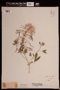 Peritoma serrulata (Pursh) de Candolle 952550[1292274]Anonymous s.n.1936-08-10 United States, Minnesota, Ramsey, St. Paul, 44.96373 -93.092335 |
MIN:Plants | Peritoma arborea (Nuttall) H.H. Iltis 453008[]Univ. of Calif. Bot. Gard. list 18 - 201976-00-00 United States, California, Ventura, Ventura Co. |
MIN:Plants | Peritoma arborea (Nuttall) H.H. Iltis 601188[]Munns, C. 3651966-02-21 United States, California, Riverside, Collected on road leading south out of Joshua Tree National Monument;Joshua Tree National Monument |
MIN:Plants | Tarenaya hassleriana (Chodat) Iltis 121632[]Beardslee, H.; et al. s.n.1891-08-01 United States, North Carolina, Swain, Great Smoky Mountains...Swain County;Great Smoky Mountains National Park, 457m |
MIN:Plants | Polanisia jamesii (Torrey & A. Gray) H.H. Iltis 914266[]Krych, S. United States, Minnesota, Scott, Detailed locality information protected. This is typically done to protect rare or threatened species localities. |
MIN:Plants | Polanisia jamesii (Torrey & A. Gray) H.H. Iltis 439779[]Morley, T. United States, Minnesota, Dakota, Detailed locality information protected. This is typically done to protect rare or threatened species localities. |
MIN:Plants | Polanisia jamesii (Torrey & A. Gray) H.H. Iltis 440735[]Smith, Welby United States, Minnesota, Dakota, Detailed locality information protected. This is typically done to protect rare or threatened species localities. |
MIN:Plants | Polanisia jamesii (Torrey & A. Gray) H.H. Iltis 456872[]Morley, T.; et al. United States, Minnesota, Dakota, Detailed locality information protected. This is typically done to protect rare or threatened species localities. |
MIN:Plants | Polanisia jamesii (Torrey & A. Gray) H.H. Iltis 456880[]Lee, Michael; et al. United States, Minnesota, Dakota, Detailed locality information protected. This is typically done to protect rare or threatened species localities. |
MIN:Plants | Polanisia jamesii (Torrey & A. Gray) H.H. Iltis 456881[]Lee, Michael; et al. United States, Minnesota, Dakota, Detailed locality information protected. This is typically done to protect rare or threatened species localities. |
MIN:Plants | Polanisia jamesii (Torrey & A. Gray) H.H. Iltis 456883[]Morley, T.; et al. United States, Minnesota, Dakota, Detailed locality information protected. This is typically done to protect rare or threatened species localities. |
MIN:Plants | Polanisia jamesii (Torrey & A. Gray) H.H. Iltis 456884[]Morley, T.; et al. United States, Minnesota, Dakota, Detailed locality information protected. This is typically done to protect rare or threatened species localities. |
MIN:Plants | Polanisia jamesii (Torrey & A. Gray) H.H. Iltis 459317[]Morley, T. United States, Minnesota, Dakota, Detailed locality information protected. This is typically done to protect rare or threatened species localities. |
MIN:Plants | Polanisia jamesii (Torrey & A. Gray) H.H. Iltis 515721[]Lee, Michael; et al. United States, Minnesota, Dakota, Detailed locality information protected. This is typically done to protect rare or threatened species localities. |
MIN:Plants | Polanisia jamesii (Torrey & A. Gray) H.H. Iltis 700646[]Ownbey, Gerald United States, Minnesota, Dakota, Detailed locality information protected. This is typically done to protect rare or threatened species localities. |
MIN:Plants | Polanisia jamesii (Torrey & A. Gray) H.H. Iltis 711589[]Smith, Welby United States, Minnesota, Dakota, Detailed locality information protected. This is typically done to protect rare or threatened species localities. |
MIN:Plants | Polanisia jamesii (Torrey & A. Gray) H.H. Iltis 743883[]Ownbey, Gerald United States, Minnesota, Dakota, Detailed locality information protected. This is typically done to protect rare or threatened species localities. |
MIN:Plants | Polanisia jamesii (Torrey & A. Gray) H.H. Iltis 813014[]Ownbey, Gerald United States, Minnesota, Washington, Detailed locality information protected. This is typically done to protect rare or threatened species localities. |
MIN:Plants | Polanisia jamesii (Torrey & A. Gray) H.H. Iltis 829806[]Fuge, E. United States, Minnesota, Dakota, Detailed locality information protected. This is typically done to protect rare or threatened species localities. |
MIN:Plants | Polanisia jamesii (Torrey & A. Gray) H.H. Iltis 832173[]Morley, T. United States, Minnesota, Dakota, Detailed locality information protected. This is typically done to protect rare or threatened species localities. |
MIN:Plants | Polanisia jamesii (Torrey & A. Gray) H.H. Iltis 832175[]Morley, T. United States, Minnesota, Dakota, Detailed locality information protected. This is typically done to protect rare or threatened species localities. |
MIN:Plants | Polanisia jamesii (Torrey & A. Gray) H.H. Iltis 842035[]Smith, Welby United States, Minnesota, Washington, Detailed locality information protected. This is typically done to protect rare or threatened species localities. |
MIN:Plants | Polanisia jamesii (Torrey & A. Gray) H.H. Iltis 842064[]Smith, Welby United States, Minnesota, Washington, Detailed locality information protected. This is typically done to protect rare or threatened species localities. |
MIN:Plants | Polanisia jamesii (Torrey & A. Gray) H.H. Iltis 914271[]Krych, S. United States, Minnesota, Scott, Detailed locality information protected. This is typically done to protect rare or threatened species localities. |
MIN:Plants | Wislizenia refracta Engelmann 590250[]Munns, C. 1781965-01-11 United States, Arizona, Pima, Quitobaquito in Organ Pipe Cactus National Monument;Organ Pipe Cactus National Monument |
MIN:Plants | Cleomella palmerana M.E. Jones 597144[]Holmgren, Noel; et al. 20581965-06-25 United States, Utah, Kane, Grand Staircase Escalante National Monument. Kane Co.: Kaiparowits Plateau, at mouth of Canyon about 22 road miles from Escalante, 4 miles west of Hole in the Rock Road. T.38 S, R.4 E, Sec.2.. 038S 04E 2, 1646m |
MIN:Plants | Cleomella palmerana M.E. Jones 608829[]Reveal, James; et al. 7921967-06-05 United States, Utah, Kane, Grand Staircase Escalante National Monument. Kane Co.: 5 airline miles southeast of Cannonville, the upper end of Kodachrome Flat, about 2.5 road miles north of the Cottomwood Wash Road, Sec. 3, T. 38S, R. 2W.. 038S 02W 3, 1890m |
MIN:Plants | Peritoma lutea (Hooker) Rafinesque 794635[]Schaaf, J. 121983-09-08 United States, Nevada, White Pine, White Pine Co. ... U.S. 6 MP 20.0 ... Elev.: 6000 ft. |
MIN:Plants | Peritoma lutea (Hooker) Rafinesque 762113[]Kittelson, J. 2281976-06-24 United States, Utah, Kane, County: Kane. Locality: Road to Kodachrome State Park, 5 miles from Cannonville...Drainage area: Paria River;Grand Staircase Escalante National Monument, 1768m |
MIN:Plants | Peritoma lutea (Hooker) Rafinesque 478681[]Anonymous s.n.1916-07-00 United States, Arizona, Navaho Reservation;Navaho Indian Reservation;;;, 35.75 -109.7333 |
MIN:Plants | Polanisia dodecandra (L.) de Candolle 430999[]Lee, Michael MDL18141997-07-09 United States, Minnesota, Stearns, Stearns Co.; Along the Mississippi River on the south side of St. Cloud; 50ft. riverbank terrace; T124N R28W SE1/4 of SE1/4 Sec. 36. 124N 28W 36, 45.507784 -94.149738 |
MIN:Plants | Polanisia dodecandra (L.) de Candolle 492611[]Gomez, N. s.n.2004-08-00 United States, Minnesota, Hennepin, Theodore Wirth Parkway, Minneapolis, Hennepin Co.;;029N;24W;00, 44.9986111 -93.3219444 |
MIN:Plants | Polanisia dodecandra (L.) de Candolle 455401[]Gomez, N. s.n.2004-08-00 United States, Minnesota, Hennepin, Collected from prairie planting along Shingle Creek Parkway, Minneapolis, Hennepin Co.;;;;, 45.0488889 -93.3122222 |
MIN:Plants | Polanisia dodecandra (L.) de Candolle 476944[]Wheeler, Gerald 201751999-08-01 United States, Minnesota, Sibley, Sibley County ... W side of Winthrop ... NW1/4 Sec. 1 T112N R29W (Alfsborg 1);;112N;29W;01, 44.53618 -94.26041 |
MIN:Plants | Polanisia dodecandra (L.) de Candolle 681229[]Swanson, Steven 19461975-07-31 United States, Wisconsin, La Crosse, Mississippi River (Navigation Pool #8)...La Crosse Co, Site 20 railroad levee built on an island;Upper Mississippi National Wildlife Refuge, 193m |
MIN:Plants | Polanisia dodecandra (L.) de Candolle 913980[]Smith, Welby 255081994-09-13 United States, Minnesota, Murray, Lake Shetek State Park. Murray County ... Lake Shetek State Park, about 3 miles northwest of Currie ... Lake Shetek ... T107N R40W SW1/4 of SW1/4 of Sec 31. 107N 40W 31, 44.1111111 -95.7011111 |
MIN:Plants | Polanisia dodecandra (L.) de Candolle 491315[]Gomez, N. s.n.2004-08-00 United States, Minnesota, Hennepin, Ridgeway Parkway, Minneapolis, Hennepin Co.;;;;, 45.0013889 -93.2186111 |
MIN:Plants | Polanisia dodecandra (L.) de Candolle 492336[]Gomez, N. s.n.2004-08-00 United States, Minnesota, Hennepin, Shingle Creek Parkway, Minneapolis, Hennepin Co.;;;;, 45.0488889 -93.3122222 |
MIN:Plants | Polanisia dodecandra (L.) de Candolle 433011[]Abbott, Robinson s.n.1963-10-11 United States, Minnesota, Stevens, Stevens County...Morris Dump, 2 1/2 mi. S.E. of Morris off rt. 9.;;124N;41W;00, 45.542242 -95.809369 |
MIN:Plants | Polanisia dodecandra (L.) de Candolle 444017[]Myhre, K. 28341992-07-24 United States, Minnesota, Cass, Cass Co.; Located one quarter mile west of Rogers Point in Leech Lake; T 142N R 29W NE1/4 of SW1/4 of Sec 31;Chippewa National Forest / Leech Lake Indian Reservation;142N;29W;31, 47.073467 -94.39543 |
MIN:Plants | Polanisia dodecandra (L.) de Candolle 507561[]Lee, Michael MDL7821994-08-08 United States, Minnesota, Fillmore, Fillmore Co. Steep, 300ft, SW-facing slope overlooking city of Rushford. Magelssen Bluff; T104N R8W NE1/4 of SW1/4 of Se Fillmore Co. Steep, 300ft, SW-facing slope overlooking city of Rushford. Magelssen Bluff; T104N R8W NE1/4 of SW1/4 of Sec 14. 104N 08W 14, 43.803542 -91.790268 |
MIN:Plants | Polanisia dodecandra (L.) de Candolle 121693[]Sheldon, Edmund S.37461892-08-00 United States, Minnesota, Otter Tail, Lake Lida, Otter Tail Co.;;136N;42W;, 46.586287 -95.968922 |
MIN:Plants | Polanisia dodecandra (L.) de Candolle 121712[]Sheldon, Edmund S4901891-06-00 United States, Minnesota, Blue Earth, Madison Lake;;109N;25W;, 44.239469 -93.828345 |
MIN:Plants | Polanisia dodecandra (L.) de Candolle 383438[]Moore, John; et al. 161801943-10-03 United States, Minnesota, Wabasha, at Lake City, Wabasha County;;111N;12W;04, 44.447017 -92.258983 |
MIN:Plants | Polanisia dodecandra (L.) de Candolle 695770[]Clemants, Steven 9801977-10-09 United States, Minnesota, Crow Wing, Crow Wing County...Pelican Lake, Sunset Beach. 13 mi. north of Brainerd...Sec. 35 & 36, T136N, R28W.;;136N;28W;, 46.588001 -94.204156 |
MIN:Plants | Polanisia dodecandra (L.) de Candolle 710049[]Wheeler, Gerald 50791979-10-06 United States, Minnesota, Le Sueur, Le Sueur County...Approx 1 mi SW of Kasota...bluff overlooking the Minnesota River. High Lime Prairie...T109N R26W Sec 6;East Minnesota River Wildlife Management Area;109N;26W;06, 44.274575 -93.998474 |
MIN:Plants | Polanisia dodecandra (L.) de Candolle 427082[]Gomez, N. s.n.2004-08-00 United States, Minnesota, Ramsey, Collected from prairie planting on St. Paul campus of the University of Minnesota, Ramsey County;;029N;23W;21, 44.9883333 -93.1830556 |
MIN:Plants | Polanisia dodecandra (L.) de Candolle 793143[]Ownbey, Gerald 72451987-10-09 United States, Minnesota, Goodhue, Goodhue County...T112N, R12W, sect. 32, NW1/4...Lake Pepin, in city park just north of Lake City.;;112N;12W;32, 44.461862 -92.279073 |
MIN:Plants | Polanisia dodecandra (L.) de Candolle 499556[]Gomez, N. s.n.2004-08-00 United States, Minnesota, Hennepin, Ridgeway Parkway, Minneapolis, Hennepin Co.;;;;, 45.0013889 -93.2186111 |
MIN:Plants | Polanisia dodecandra (L.) de Candolle 927184[]Grether, David 86031957-09-06 United States, Minnesota, Stearns, Gravel quarry between Clearwater road & Stillerd County Club.;;124N;28W;25, 45.52088 -94.150481 |
MIN:Plants | Polanisia dodecandra (L.) de Candolle 923417[]Smith, Welby 220191992-09-17 United States, Minnesota, Nicollet, About 1.5 miles NNW of Judson. NE1/4 of SW1/4 of section.;Swan Lake Wildlife Management Area;109N;28W;28, 44.2172222 -94.2033333 |
MIN:Plants | 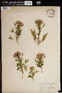 Polanisia dodecandra (L.) de Candolle 965877[1356632] 1944-08-21 United States, South Dakota, Codington, Alkaline lake |
MIN:Plants | 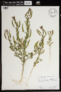 Polanisia dodecandra (L.) de Candolle 966797[1359520]Anderson, Derek S. 27292017-08-19 United States, Minnesota, Polk, Thorson WPA. About 2 km west of Melvin on County Road 41., 47.62 -96.4 |
MIN:Plants | 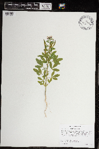 Polanisia dodecandra (L.) de Candolle 968944[1391622]Walden, Jacob 01462020-08-31 United States, Minnesota, Lake, East of Birch Lake, approximately 2.2 km southwest of the intersection of Hwy 1 and Spruce Rd and 3.2 km southeast of the intersection of Hwy 1 and Little Lake Rd., 47.799348 -91.755826 |
MIN:Plants |  Polanisia dodecandra (L.) de Candolle 969047[1391713]Rowe, Erika R. ERR9002016-07-09 United States, Minnesota, Winona, Great River Bluffs State Park. Approx. 0.25 meters west of New Harford Twp. Rd 28; 0.25 miles north of Interstate 90; 1.75 miles northwest of Dakota., 43.93 -91.39 |
MIN:Plants |  Polanisia dodecandra (L.) de Candolle 966629[1359327]Whitfeld, T.J.S., Yang, Y., & Lee, A.K. 30932021-08-23 United States, Minnesota, Crow Wing, Cross Lake Recreation Area; Big Trout Lake; shoreline, 46.72 -94.13 |
MIN:Plants |  Polanisia dodecandra (L.) de Candolle 0971214[1394687]Bolduan, Brad 2242021-08-01 United States, Minnesota, Rock, P.F. Mulder Wildlife Management Area. growing on disturbed sandy soil above the Rock River, 43.6162 -96.19773 |
MIN:Plants |  Polanisia dodecandra (L.) de Candolle 974718[1397485]Dunevitz, Hannah L. 4311991-07-27 United States, Minnesota, Goodhue, in the River Terrace Prairie Scientific and Natural Area. 5 miles northeast of Cannon Falls on a lower west-facing slope, 44.54 -92.8 |
MIN:Plants | Polanisia dodecandra subsp. trachysperma (Torrey & A. Gray) H.H. Iltis 396092[]Fitzpatrick, T.; et al. 17971895-07-03 United States, Iowa, Allamakee, Allamakee Co |
MIN:Plants | Polanisia dodecandra subsp. trachysperma (Torrey & A. Gray) H.H. Iltis 460278[]Smith, Welby 132271987-06-27 United States, Minnesota, Pipestone, Pipestone County...Altona state Wildlife Management Area, about 1.5 mi SE of Verdi...NW1/4 NW1/4 section 1, T 108N R 46W;Altona Wildlife Management Area;108N;46W;01, 44.190127 -96.318183 |
MIN:Plants | Polanisia dodecandra subsp. trachysperma (Torrey & A. Gray) H.H. Iltis 542324[]Moore, John 213471951-08-10 United States, Minnesota, Grant, Grant County...3 miles east of Elbow Lake.;;129N;42W;11, 45.999507 -95.924672 |
MIN:Plants | Polanisia dodecandra subsp. trachysperma (Torrey & A. Gray) H.H. Iltis 558123[]Stevens, O. 21661959-08-30 United States, Minnesota, Clay, gravel pit, Downer (Clay Co.);;138N;46W;21, 46.754127 -96.494052 |
MIN:Plants | Polanisia dodecandra subsp. trachysperma (Torrey & A. Gray) H.H. Iltis 611348[]Hsi, Yu-tseng [Eugene] 10251969-07-14 United States, Minnesota, Lyon, Lyon County...Along roadside leading to state conservation area ca. 1-1/2 m. SW of Camden State Park;Russell Wildlife Management Area;110N;42W;18, 44.334173 -95.947683 |
MIN:Plants | Polanisia dodecandra subsp. trachysperma (Torrey & A. Gray) H.H. Iltis 336989[]Lakela, Olga 18641936-09-15 United States, Minnesota, Saint Louis, on Minnesota Ave. at 42nd Street, Duluth.;;;;, 46.746681 -92.06783 |
MIN:Plants | Polanisia dodecandra subsp. trachysperma (Torrey & A. Gray) H.H. Iltis 489699[]Stevens, O. s.n.1934-07-22 United States, Minnesota, Becker, Lake Park.;;139N;43W;, 46.847905 -96.112303 |
MIN:Plants | Polanisia dodecandra subsp. trachysperma (Torrey & A. Gray) H.H. Iltis 685149[]Stassen, Carol 1571977-06-27 United States, Minnesota, Lyon, Camden State Park; T110N, R42W.;Camden State Park;110N;42W;, 44.326783 -95.897167 |
MIN:Plants | Polanisia dodecandra subsp. trachysperma (Torrey & A. Gray) H.H. Iltis 685151[]Stassen, Carol 2141977-07-15 United States, Minnesota, Lyon, Camden State Park; T110N, R42W, Sec. 17, SE1/4. SW of Lake Brauner.;Camden State Park;110N;42W;17, 44.333919 -95.927237 |
MIN:Plants | Peritoma arborea var. angustata (Parish) H.H. Iltis 637838[]Livingston, Enid s.n.1969-04-00 United States, California, Joshua Tree Natl Mon.;Joshua Tree National Monument |
MIN:Plants | 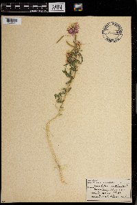 Cleome serrulata Pursh 0968736[1391334]Bieberdorf, Fred W. s.n.1941-00-00 United States, Yellowstone Nat'l Park |
MIN:Plants | 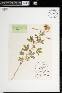 Cleome serrulata Pursh [1397736]Messerschmidt, W. s.n.1979-06-25 United States, Montana, Dawson, 2.4 km southeast of Glendive, Makoshika State Park, roadside, 622m |
MIN:Plants | Cristatella jamesii Torr. & A. Gray 0967747[1368308]F.W. Bieberdorf United States, Oklahoma, Detailed locality information protected. This is typically done to protect rare or threatened species localities. |
MIN:Plants | 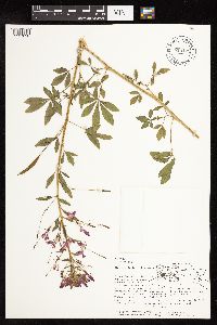 Cleome pringlei Iltis 618122[1127638]Iltis, H.H. 8321960-08-10 Mexico, Michoacan, 2 km N of Sahuayo, on road to La Barca, basin of Lago Chapalla, 20.07664 -102.715747, 1500m |
MIN:Plants | 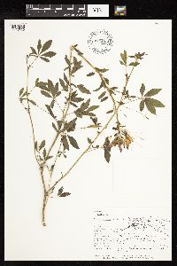 Cleome pringlei Iltis 618126[1127639]Iltis, H.H. 8321961-09-15 Mexico, Michoacan, 2 km N of Sahuayo, on road to La Barca, basin of Lago Chapalla, 20.07664 -102.715747, 1500m |
MIN:Plants | 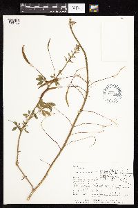 Cleome pringlei Iltis 618112[1127640]Iltis, H.H. 8321961-09-15 Mexico, Michoacan, 2 km N of Sahuayo, on road to La Barca, basin of Lago Chapalla, 20.07664 -102.715747, 1500m |
MIN:Plants | 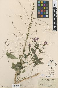 Gynandropsis tracyi Briq. 121577[1001288]Tracy, S.M. 76671901-12-10 United States, Florida, Manatee, Palma Sola |
MIN:Plants | Polanisia dodecandra subsp. dodecandra (L.) de Candolle 919355[]Cholewa, A. 27702010-07-15 United States, Minnesota, Anoka, Coon Rapids Dam County Park, south end of Cenaiko Lake. ;Coon Rapids Dam County Park;031N;24W;35, 45.1375 -93.3002778 |
MIN:Plants | Polanisia dodecandra subsp. dodecandra (L.) de Candolle 269049[]Fassett, N.; et al. 42221927-08-29 United States, Wisconsin, Pierce, Pierce Co. ...Lake Pepin. Bay City. |
MIN:Plants | Polanisia dodecandra subsp. dodecandra (L.) de Candolle 246928[]Bergman, H.; et al. 5351910-07-19 United States, North Dakota, Cass, Fargo. |
MIN:Plants | Polanisia dodecandra subsp. dodecandra (L.) de Candolle 396055[]Chase, Agnes s.n.1897-08-16 United States, Indiana, Porter, Dune Park, Porter Co.;Indiana Dunes National Lakeshore;;;, 41.663093 -87.032128 |
MIN:Plants | Polanisia dodecandra subsp. dodecandra (L.) de Candolle 455094[]Wheeler, Gerald 202831999-08-13 United States, Minnesota, Scott, Ca. 1 mi. W of Belle Plaine on Rte. 6, S of road. NW1/4 SE1/4 of section;;113N;25W;02, 44.622771 -93.798779 |
MIN:Plants | Polanisia dodecandra subsp. dodecandra (L.) de Candolle 493452[]Juhnke, C. 087 CMJ FRO1998-09-02 United States, Minnesota, Goodhue, Frontenac State Park. Goodhue County ... Sand Point beach along Mississippi River ... T112N R13W SE SW SE 12;Frontenac State Park;112N;13W;12, 44.519822 -92.319123 |
MIN:Plants | Polanisia dodecandra subsp. dodecandra (L.) de Candolle 436053[]Wheeler, Gerald 173231997-08-28 United States, Minnesota, Nicollet, Nicollet Co.; Ca. 2.5 mi. NW of Courtland on Rte. 14, S or road, sandy area N of quarry; S1/2 NE1/4 SW1/4 Sec. 35 T110N R30W (Courtland 35). 110N 30W 35, 44.290079 -94.401883 |
MIN:Plants | Polanisia dodecandra subsp. dodecandra (L.) de Candolle 439785[]Harris, Fred 950481995-08-18 United States, Minnesota, Scott, Scott County...along Robert creek...terrace of Minnesota river...T113 R25 SE1/4 of SE1/4 of Sec 2;;113N;25W;02, 44.622771 -93.798779 |
MIN:Plants | Polanisia dodecandra subsp. dodecandra (L.) de Candolle 841200[]Smith, Welby 137571987-08-06 United States, Minnesota, Washington, Washington County...Island in Conoly Lake on the Mississippi River Bottoms; about 2 mi west of Point Douglas...SE1/4 SW1/4 section 8, T26N R20W. 026N 20W 8, 44.7508316 -92.8344421 |
MIN:Plants | Polanisia dodecandra subsp. dodecandra (L.) de Candolle 842053[]Smith, Welby 150201988-09-01 United States, Minnesota, Washington, Washington County...About 4 mi S of Cottage Grove...terrace above the Mississippi River...SE1/4 NE1/4 section 35, T27N R21W. 027N 21W 35, 44.7827778 -92.8847222 |
MIN:Plants | Polanisia dodecandra subsp. dodecandra (L.) de Candolle 121600[]Rosendahl, C.; et al. s.n.1917-09-00 United States, Minnesota, Anoka, Moore Lake.;;030N;24W;, 45.080985 -93.255535 |
MIN:Plants | Polanisia dodecandra subsp. dodecandra (L.) de Candolle 121674[]Skinner, S. 2521902-06-30 United States, Minnesota, Nobles, Graham Lake. Heron Lake region.;;N;;, 43.79675 -95.50295 |
MIN:Plants | Polanisia dodecandra subsp. dodecandra (L.) de Candolle 121686[]Burglehaus, F. s.n.1891-07-00 United States, Minnesota, Hennepin, [no further data];;;;, 45 -93.47 |
MIN:Plants | Polanisia dodecandra subsp. dodecandra (L.) de Candolle 121687[]Manning, Sara s.n.1883-07-13 United States, Minnesota, Wabasha, Lake City;;N;;, 44.442549 -92.278517 |
MIN:Plants | Polanisia dodecandra subsp. dodecandra (L.) de Candolle 121688[]Rosendahl, C.; et al. 40781921-06-19 United States, Minnesota, Otter Tail, Shores of Otter Tail lake;;;;, 46.39667 -95.66277 |
Google Map
Google Maps is a web mapping service provided by Google that features a map that users can pan (by dragging the mouse) and zoom (by using the mouse wheel). Collection points are displayed as colored markers that when clicked on, displays the full information for that collection. When multiple species are queried (separated by semi-colons), different colored markers denote each individual species.