University of Minnesota
http://www.umn.edu/
612-625-5000
http://www.umn.edu/
612-625-5000
Minnesota Biodiversity Atlas
Bell Museum
Dataset: MIN-Plants
Taxa: Clethraceae
Search Criteria: excluding cultivated/captive occurrences
1
Page 1, records 1-15 of 15
Bell Museum plants | |
 MIN:Plants | 477539[]US Nat. Arboretum staff 691978-00-00 United States, New Jersey, Burlington, Burlington Co. |
MIN:Plants | 289154[]Beardslee, H.; et al. s.n.1891-07-25 United States, North Carolina, Swain, Great Smoky Mountains...Tuckaseegee River, Swain County;Great Smoky Mountains National Park, 518m |
MIN:Plants | 166474[]Beardslee, H.; et al. s.n.1891-07-25 United States, North Carolina, Swain, Great Smoky Mountains...Tuckaseegee River, Swain County;Great Smoky Mountains National Park, 518m |
MIN:Plants | 511644[]US Nat. Arboretum staff 77-661977-00-00 United States, Maryland, Somerset, Somerset Co. |
MIN:Plants | 166475[]Beardslee, H.; et al. s.n.1891-07-25 United States, North Carolina, Swain, Great Smoky Mountains...Tuckaseegee River, Swain County;Great Smoky Mountains National Park, 518m |
MIN:Plants | 247490[]Brainerd, E. s.n.1877-00-00 United States, Massachusetts, Barnstable, Cape Cod;Cape Cod National Seashore |
MIN:Plants | 511642[]Arboretum, Cary 73-181973-00-00 United States, New York, Dutchess, Dutchess Co. |
MIN:Plants | 510333[]US Nat. Arboretum staff 371974-00-00 United States, District of Columbia, USNA [Nat. Arboretum] |
MIN:Plants | 511641[]US Nat. Arboretum staff 701978-00-00 United States, Virginia, Surry, Surry Co. |
MIN:Plants |  953743[1294741]Mowery, May s.n.1928-07-08 United States, Massachusetts, Barnstable, Woods Hole and vicinity |
MIN:Plants |  953742[1294742]Mowery, May s.n.1928-08-23 United States, Massachusetts, Barnstable, Woods Hole and vicinity |
MIN:Plants |  968265[1368839]Meghan N. Hershkowitz 312017-09-29 United States, Rhode Island, Newport, Simmons Mill Wildlife Management Area, 250 meters east of intersecton of Colebrook Road and Long Hwy., 41.5392611111 -71.1528277778, 35m |
MIN:Plants |  Clethra alcoceri Greenman 166497[1000672]Pringle, C.G. 89231904-08-22 Mexico, Hidalgo, Barranca below Trinidad Iron Works, 1615m |
MIN:Plants | 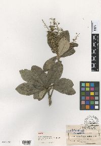 Clethra pringlei S. Watson 166520[1000673]Pringle, C.G. 30981890-06-14 Mexico, San Luis Potosi, Tamasopo Canyon |
MIN:Plants | 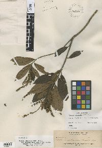 Clethra castanea A.D.E. Elmer 929493[1002831]Elmer, A.D.E. 223981927-05-00 Philippines, Pampanga, Luzon; Camp Stotsenburg (Mt. Pinatubo) Pampanga Province |
1
Page 1, records 1-15 of 15
Google Map
Google Maps is a web mapping service provided by Google that features a map that users can pan (by dragging the mouse) and zoom (by using the mouse wheel). Collection points are displayed as colored markers that when clicked on, displays the full information for that collection. When multiple species are queried (separated by semi-colons), different colored markers denote each individual species.