University of Minnesota
http://www.umn.edu/
612-625-5000
http://www.umn.edu/
612-625-5000
Minnesota Biodiversity Atlas
Bell Museum
Dataset: MIN-Plants
Taxa: Comandraceae
Search Criteria: excluding cultivated/captive occurrences
Bell Museum plants | |
 MIN:Plants | Comandra umbellata (L.) Nuttall 429484[]Smith, Welby 195561991-07-16 United States, Minnesota, Koochiching, Koochiching State Forest. Koochiching Co.; On the north side of TH 65, about 18 miles northwest of Silverdale T 65 Koochiching Co.; On the north side of TH 65, about 18 miles northwest of Silverdale; T 65N R 24W SE1/4 of NE1/4 of Sec 3. 065N 24W 3, 48.1500015 -93.4186096 |
MIN:Plants | Comandra umbellata (L.) Nuttall 461570[]Smith, Welby 114181986-05-16 United States, Minnesota, Sherburne, Sherburne Co. Sherburne National Wildlife Refuge, about 2.5 mi SE of Santiago. SW1/4 NW1/4 sec 23, T35N R28W;Sherburne National Wildlife Refuge;023N;28W;23, 45.5074997 -93.7938919 |
MIN:Plants | Comandra umbellata (L.) Nuttall 840422[]Smith, Welby 126551987-05-08 United States, Minnesota, Washington, Washington Co. About 5 mi NE of Hastings; SE1/4 NE1/4 sec.29, T27N R20W;Lost Valley Prairie Scientific Natural Area;027N;20W;29, 44.8002777 -92.8194427 |
MIN:Plants | 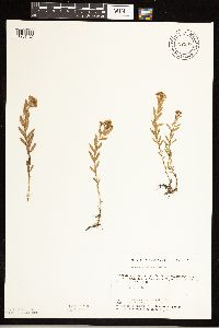 Comandra umbellata (L.) Nuttall 727997[1261123]Severson, M. 101979-06-18 United States, Minnesota, Polk, Pankratz Prairie South: 7 mi. SE of Crookston. SE1/4 of Sec. 17, NE1/4 of Sec. 20, T149N, R45W. [Pankratz Memorial Prairie, The Nature Conservancy], 47.723975 -96.4489 |
MIN:Plants | Comandra umbellata (L.) Nuttall 539877[]Tester, John s.n.1957-05-22 United States, Minnesota, Mahnomen, 3-4 miles w. and 1 mile s. of Waubun. ;Waubun Prairie Wildlife Management Area / White Earth Indian Reservation;143N;42W;33, 47.166009 -96.024401 |
MIN:Plants | Comandra umbellata (L.) Nuttall 930626[]Gerdes, Lynden B.; Doerr, Andrea L. 61252010-07-19 United States, Minnesota, Cook, Portage between Paulson Lake and Sea Gull Lake; approximately 0.20 miles northwest of the Paulson Lake landing. SENWNW of section;Superior National Forest;065N;05W;24, 48.1030556 -90.9175 |
MIN:Plants | Comandra umbellata (L.) Nuttall 937545[]Gerdes, Lynden B. 64822012-05-21 United States, Minnesota, Lake, Approximately 9.81 miles ENE of Babbitt, MN and 0.64 miles NW of Sue Lake. Just west off FR 428.;Superior National Forest;061N;11W;28, 47.735833 -91.730278 |
MIN:Plants | Comandra umbellata (L.) Nuttall 238922[]Congdon, J. W. s.n.1885-07-01 United States, California, Mariposa, Yosemite Road [Yosemite National Park] |
MIN:Plants | Comandra umbellata (L.) Nuttall 238989[]Congdon, J. W. s.n.1890-08-10 United States, California, Mariposa, Crescent Lake [Yosemite National Park |
MIN:Plants | 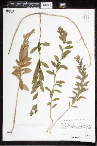 Comandra umbellata (L.) Nuttall 959897[1318194]Anderson, Chel E. 24772017-08-04 United States, Minnesota, Koochiching, ~17 mi SW from Big Falls on Hwy 71; ~2 mi W on Koochiching Cty NFR90; in abandoned gravel pit just south and adjacent to of Gemmell Rd., 48.02 -94.1 |
MIN:Plants | 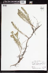 Comandra umbellata (L.) Nuttall 961019[1334099]Boyd, Crystal CLB2016012016-05-19 United States, Minnesota, Wilkin, Richard M. and Mathilde Rice Elliot SNA. 6 miles SE of Barnesville; 8 miles NW of Rothsay. 1.5 miles east of Co. Hwy. 52 on County Road 188. Site along south side of County Road 188. T136N R45W NW1/4 of NW1/4 Sec. 21, 46.58722 -96.36438 |
MIN:Plants | 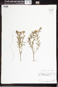 Comandra umbellata (L.) Nuttall 960966[1334049]Anderson, Derek S. 25412016-05-18 United States, Minnesota, Swift, Hamann WPA, About 18.5 km west-northwest of Benson. About 6 km east of U.S. Hwy 59 on 40th St. NW., 45.35 -95.83 |
MIN:Plants |  Comandra umbellata (L.) Nuttall 961352[1334956]Kaliher, Earl L. 1927-00-00 United States, Minnesota, Todd, Ward Springs, 45.791389 -94.808333 |
MIN:Plants |  Comandra umbellata (L.) Nuttall 961353[1334957]Kramer, Leona 1927-00-00 United States, Minnesota, Mower |
MIN:Plants |  Comandra umbellata (L.) Nuttall 961354[1334958]Marsh, Lucian United States, Minnesota, Cass |
MIN:Plants |  Comandra umbellata (L.) Nuttall 961355[1334959]Stork, H. E. 1927-05-14 United States, Minnesota, Goodhue, Goodhue co; Ball Creek Valley, 44.409846 -92.722591 |
MIN:Plants |  Comandra umbellata (L.) Nuttall 961551[1334980] United States, Michigan |
MIN:Plants |  Comandra umbellata (L.) Nuttall 961550[1334981] United States, Maine |
MIN:Plants |  Comandra umbellata (L.) Nuttall 961549[1334982] United States, Illinois |
MIN:Plants |  Comandra umbellata (L.) Nuttall 961548[1334983] United States, Indiana |
MIN:Plants |  Comandra umbellata (L.) Nuttall 961547[1334984] United States, Iowa |
MIN:Plants | Comandra umbellata (L.) Nuttall []Timothy J. S. Whitfeld 32372022-06-16 United States, Minnesota, Washington, Crystal Spring Scientific and Natural Area, 0.4 miles northeast of the intersection of Scandia Trail North and Hwy 95, 45.25756 -92.764544, 273m |
MIN:Plants |  Comandra umbellata (L.) Nuttall 970762[1394243]Smith, Welby R WRS357022017-06-13 United States, Minnesota, Dodge, 10.6 km (6.6 miles) east of approximate center of the town of Hayfield at heading of 86 degrees., 43.8968056 -92.7145556 |
MIN:Plants | Geocaulon lividum (Richardson) Fernald 432232[]Lee, Michael MDL26581999-08-04 United States, Minnesota, Lake, Lake County...Ten miles northeast of Toimi...1-1/2 miles east of Greenwood Lake...T58N R10W NE1/4 of SW1/4 Sec. 10;Superior National Forest;058N;10W;10, 47.518697 -91.60039 |
MIN:Plants | Geocaulon lividum (Richardson) Fernald 490435[]Gerdes, Lynden 48782004-07-19 United States, Minnesota, Lake, Superior National Forest. T61N R06W S19NESWS. Lake County...Superior National Forest. Approximately 13.60 miles NE of Isabella, MN and 0.30 mile N of Silver Island Lake.. 061N 06W 19, 47.738385 -91.142856 |
MIN:Plants | Geocaulon lividum (Richardson) Fernald 438071[]Aaseng, N. 91719131991-07-19 United States, Minnesota, Roseau, Roseau County ... Bemis Peatland, Beltrami Island State Forest ...T160N R38W Sec.01 SE/NE;Beltrami Island State Forest;160N;38W;01, 48.706044 -95.483912 |
MIN:Plants | Geocaulon lividum (Richardson) Fernald 499507[]Aaseng, N. 91724041991-07-24 United States, Minnesota, Roseau, Lost River State Forest / Sprague Creek Peatland Scientific Natural Area. Roseau County ... Sprague Creek Peatland, Lost River State Forest, ~2.5 mi. east of Hwy. 310 near Canadian border ... NE1/4 SW1/4 Sec.29 T164N R39W. 164N 39W 29, 48.9991667 -95.7183333 |
MIN:Plants | Geocaulon lividum (Richardson) Fernald 499515[]Aaseng, N. 91726011991-07-26 United States, Minnesota, Roseau, Beltrami Island State Forest. Roseau County ... East end of Bemis Peatland, Beltrami Island State Forest, approx. 1 mi. west of Co. Rd. 5 ... NW1/4 NE1/4 Sec.25 T161N R36W. 161N 36W 25, 48.74 -95.3613889 |
MIN:Plants | Geocaulon lividum (Richardson) Fernald 439321[]Pomroy, Deborah DLP19502004-07-08 United States, Minnesota, Saint Louis, Superior National Forest. St. Louis County, Hoyt Lakes. T59N R13W NE1/4 of SE1/4 Sec 3. Peter Mitchell Mine, NE of Hoyt Lakes ...'Hundred Mile Swamp' ... UTM: 577447E 5274887N. Babbitt SW Quad.. 059N 13W 3, 47.622543 -91.977918 |
MIN:Plants | Geocaulon lividum (Richardson) Fernald 436697[]Aaseng, N. 92609021992-06-09 United States, Minnesota, Roseau, Roseau County ... Approx. 0.2 mi. E of Minnesota Hill, approx. 20 m. S of Canadian Border ... T164N R40W Sec.29 NW/SW;Lost River State Forest;164N;40W;29, 48.90752 -95.582509 |
MIN:Plants | Geocaulon lividum (Richardson) Fernald 918143[]Gerdes, D. Lawson; et al. 7792009-09-15 United States, Minnesota, Cook, Superior National Forest. T63N R01W S26NENW. Cook County...Approximately 2.5 miles southeast of the Brule River along FR152 (Lima Mt. Grade), 0.8 miles west to rich black spruce swamp forest.. 063N 01W 26, 47.9175 -90.4163889 |
MIN:Plants | Geocaulon lividum (Richardson) Fernald 493886[]Aaseng, N. 91725011991-07-25 United States, Minnesota, Roseau, Lost River State Forest / Sprague Creek Peatland Scientific Natural Area. Roseau County ... Sprague Creek Peatland, Lost River State Forest ...south of spring fen area...SW1/4 SW1/4 Sec.35 T164N R40W. 164N 40W 35, 48.9802778 -95.7866667 |
MIN:Plants | Geocaulon lividum (Richardson) Fernald 288039[]Aaseng, N. 92601011992-06-01 United States, Minnesota, Roseau, Beltrami Island State Forest. Roseau County ... Approx. 2.5 mi. NE of Bemis Hill in Bemis Peatland, Beltrami Island State Forest ... T161N R37W Sec.27 NW/SW. 161N 37W 27, 48.734586 -95.406911 |
MIN:Plants | Geocaulon lividum (Richardson) Fernald 438951[]Lee, Michael MDL29292001-06-12 United States, Minnesota, Lake, Superior National Forest. Lake County ... Along Moose Creek on the northeast side of Moose Lake, four miles northwest of Cramer ... T59N R6W SE1/4 of NW1/4 of NW1/4 Sec. 29, NW1/4 of SW1/4 of NW1/4 Sec. 29. 059N 06W 29, 47.562697 -91.137425 |
MIN:Plants | Geocaulon lividum (Richardson) Fernald 505486[]Gerdes, D. Lawson 6072004-08-13 United States, Minnesota, Lake, Superior National Forest. T60N R09W S05 NWNWNE Lake County ...Superior National Forest. Approximately 9.76 miles NW of Isabella, MN and 1.0 mile NE of Surprise Lake.. 060N 09W 5, 47.711387 -91.501877 |
MIN:Plants | Geocaulon lividum (Richardson) Fernald 493881[]Aaseng, N. 92903051992-09-03 United States, Minnesota, Roseau, Roseau County ... Approx. 8 mi. W of Hwy 310, approx. 30 m. S. of Canadian Border ...T164N R40W Sec.26 NW/SW;Lost River State Forest;164N;40W;26, 48.912766 -95.648341 |
MIN:Plants | Geocaulon lividum (Richardson) Fernald 918140[]Gerdes, D. Lawson 6582007-06-12 United States, Minnesota, Lake, Superior National Forest. T61N R10W S29NWSW. Lake County MN. Superior National Forest. Approx. 0.2 miles east of State Hwy 1 and 0.1 miles east of Little Spring Lake (Isabella, MN).. 061N 10W 29, 47.7388889 -91.6361111 |
MIN:Plants | Geocaulon lividum (Richardson) Fernald 918134[]Gerdes, D. Lawson; et al. 5322009-06-29 United States, Minnesota, Cook, Boundary Waters Canoe Area Wilderness / Superior National Forest. T65N R02W S17SESE Cook County, MN. Superior National Forest (BWCAW)...at east end of Gunflint Lake, approx. 0.6 miles east of lakeshore. 065N 02W 17, 48.1111111 -90.6025 |
MIN:Plants | Geocaulon lividum (Richardson) Fernald 499506[]Aaseng, N. 92826041992-08-26 United States, Minnesota, Roseau, Roseau County ... Approx. 1.5 mi. W of Hwy 310, approx. 0.5 mi. S of Canadian Border ... T164N R40W Sec.34 NW/NE;Lost River State Forest / Sprague Creek Peatland Scientific Natural Area;164N;40W;34, 48.993363 -95.800803 |
MIN:Plants | Geocaulon lividum (Richardson) Fernald 914775[]Gerdes, Lynden 57962009-07-14 United States, Minnesota, Cook, Superior National Forest. T64N R02E S14SESENESE. Cook County. Superior National Forest. Greenwood Lake area. North of FR 313 and approximately 0.23 miles southeast of Tittle Lake.. 064N 02E 14, 48.0241667 -90.1486111 |
MIN:Plants | Geocaulon lividum (Richardson) Fernald 228833[]Butters, F.; et al. 45601924-07-03 United States, Minnesota, Cook, Pigeon River, near Trunk Highway No. 1 [probably meant 61].;Grand Portage Indian Reservation / North Shore;064N;07E;29, 48.010163 -89.708422 |
MIN:Plants | Geocaulon lividum (Richardson) Fernald 273259[]Rosendahl, C. 60031929-08-11 United States, Minnesota, Cook, Along west side Grand Portage Bay;Grand Portage Indian Reservation / North Shore;063N;06E;09, 47.962387 -89.683423 |
MIN:Plants | Geocaulon lividum (Richardson) Fernald 393193[]Ownbey, Gerald; et al. 11531948-08-19 United States, Minnesota, Cook, Cook County...On northern most island west of Susie Island, Susie Islands near Grand Portage...at east end of island.;North Shore / Susie Islands, The Nature Conservancy;064N;07E;32, 47.973776 -89.578978 |
MIN:Plants | Geocaulon lividum (Richardson) Fernald 393194[]Ownbey, Gerald; et al. 10961948-08-16 United States, Minnesota, Cook, Cook County...Sailboat Island, Susie Islands near Grand Portage.;North Shore / Susie Islands, The Nature Conservancy;063N;07E;00, 47.973776 -89.578978 |
MIN:Plants | Geocaulon lividum (Richardson) Fernald 401065[]Butters, F.; Burns, G. 7311940-07-05 United States, Minnesota, Cook, Cook County...on small point in Morrison Bay, south side of Pigeon Point. Twp. 64N R.7E.;Grand Portage Indian Reservation / North Shore;064N;07E;32, 47.997942 -89.538143 |
MIN:Plants | Geocaulon lividum (Richardson) Fernald 412340[]Colson, E. 109831939-07-18 United States, Minnesota, Lake of the Woods, Lake of the Woods County...east side of Pine Creek, Angle Inlet.;Northwest Angle;168N;34W;29, 49.051968 -94.954539 |
MIN:Plants | Geocaulon lividum (Richardson) Fernald 543491[]Lakela, Olga; Davidson, Donald 217361957-07-26 United States, Minnesota, Lake, Tomahawk Trail, west of Isabella Lake; Lake Co. (6.3 mi. E of Hwy. 1).;Superior National Forest;060N;08W;10, 47.800713 -91.52116 |
MIN:Plants | Geocaulon lividum (Richardson) Fernald 582120[]Piehl, M. 56031956-07-15 United States, Minnesota, Cook, Grand Portage Indian Reservation / North Shore. Adjoining road running along immediate shore of Grand Portage Bay just n of old fort. Possibly same site as Rosendahl 6003. T063N R06E S4, 47.969475 -89.684842 |
MIN:Plants | Geocaulon lividum (Richardson) Fernald 699055[]Sather, Nancy; et al. 3731977-06-14 United States, Minnesota, Lake, Lake County...plot T05. SE1/4 NE1/4 Sec. 26, T61N, R10W.;Superior National Forest;061N;10W;26, 47.740548 -91.565635 |
MIN:Plants | Geocaulon lividum (Richardson) Fernald 702036[]Sather, Nancy; et al. 3731977-06-14 United States, Minnesota, Lake, Lake County...Plot T05. SE1/4 NE1/4 Sec. 26, T61N, R10W.;Superior National Forest;061N;10W;26, 47.740548 -91.565635 |
MIN:Plants | Geocaulon lividum (Richardson) Fernald 724606[]Smith, Welby 25281980-06-14 United States, Minnesota, Lake, Lake County...T 59 N, R 10 W, NW1/4 section 5.;Superior National Forest;059N;10W;05, 47.625514 -91.629364 |
MIN:Plants | Geocaulon lividum (Richardson) Fernald 773645[]Boe, J. 10231979-07-22 United States, Minnesota, Lake of the Woods, Lake of the Woods County...T 159 N, R 34 W, sec. 9.;Beltrami Island State Forest;159N;34W;09, 48.605103 -95.028358 |
MIN:Plants | Geocaulon lividum (Richardson) Fernald 805753[]Gerdes, Lynden; et al. 322B1990-06-21 United States, Minnesota, Lake, County: Lake. T61N R10W S32. Location: 1/4 mile N on Hwy 1 from junction with F.R. 173 (Tomahwk Rd.) -- 1/8 mile east;Superior National Forest;061N;10W;32, 47.726204 -91.63027 |
MIN:Plants | Geocaulon lividum (Richardson) Fernald 816850[]Sather, Nancy 88-1421988-07-10 United States, Minnesota, Saint Louis, St. Louis County...SENESE Sec. 33, T061N, R21W;Sturgeon River State Forest;061N;21W;33, 47.7249985 -93.0216675 |
MIN:Plants | Geocaulon lividum (Richardson) Fernald 430368[]Scott, P. 10531997-08-19 United States, Minnesota, Cook, Cook Co. ... at Spark Lake T64NR2E sec.31 SENWSE.;Superior National Forest;064N;02E;31, 47.983596 -90.243195 |
MIN:Plants | Geocaulon lividum (Richardson) Fernald 441647[]Gerdes, Lynden; et al. 34971999-06-24 United States, Minnesota, Cook, Superior National Forest. T65N R02W S17SWSE. Cook County...Superior National Forest. Thuja/Picea swamp south of small drainage entering the northeasternmost bay of Gunflint Lake.. 065N 02W 17, 48.09615 -90.694288 |
MIN:Plants | Geocaulon lividum (Richardson) Fernald 476270[]Gerdes, Lynden 27691998-06-22 United States, Minnesota, Cook, Boundary Waters Canoe Area Wilderness / Superior National Forest. T64N R01E S04NESE. Cook County...Superior National Forest. Approximately .25 miles NE of the Northeastern Arm of East Bearskin Lake.. T064N R01E S4, 48.055409 -90.328464 |
MIN:Plants | Geocaulon lividum (Richardson) Fernald 476271[]Gerdes, Lynden; et al. 32221998-08-26 United States, Minnesota, Cook, T64N R02E S07NWNE. Cook County...Superior National Forest. East of Pierz Lake in a Picea mariana swamp.;Superior National Forest;064N;02E;07, 48.04129 -90.241743 |
MIN:Plants | Geocaulon lividum (Richardson) Fernald 519148[]Lederle, K. 8324011983-08-17 United States, Minnesota, Cook, Northern periphery of bog lake, east of Pike Lake...Cook Co. NESW 11 T61N R2W;North Shore / Superior National Forest; T061N R02W S11, 47.781061 -90.542699 |
MIN:Plants | Geocaulon lividum (Richardson) Fernald 519352[]Scott, P. 10451997-08-18 United States, Minnesota, Cook, Cook Co. In bog forest near Kindle Lake at Shoe Lake Road T64NR2E sec.31 NWSWNE and NESENW.;Superior National Forest;064N;02E;31, 47.983596 -90.243195 |
MIN:Plants | Geocaulon lividum (Richardson) Fernald 829603[]Boe, J. 920608051992-06-08 United States, Minnesota, Roseau, Roseau County...Beltrami Island State Forest...NE1/4 SW1/4 Sec.23 T161N R37W.;Beltrami Island State Forest;161N;37W;23, 48.749032 -95.384856 |
MIN:Plants | Geocaulon lividum (Richardson) Fernald 829604[]Boe, J. 920607041992-06-07 United States, Minnesota, Roseau, Roseau County...Beltrami Island State Forest...SW1/4 NE1/4 Sec.26 T161N R37W;Beltrami Island State Forest;161N;37W;26, 48.734613 -95.385109 |
MIN:Plants | Geocaulon lividum (Richardson) Fernald 829605[]Boe, J. 920607011992-06-07 United States, Minnesota, Roseau, Roseau County...Beltrami Island State Forest...SE1/4 NW1/4 Sec.26 T161N R37W.;Beltrami Island State Forest;161N;37W;26, 48.734613 -95.385109 |
MIN:Plants | Geocaulon lividum (Richardson) Fernald 829628[]Boe, J. 920910041992-09-10 United States, Minnesota, Roseau, Roseau County...Beltrami Island State Forest...north of Pine Ridge Cemetary on Bednar Trail...Releve BS-150-Bed. etc.;Beltrami Island State Forest;161N;36W;26, 48.734613 -95.385109 |
MIN:Plants | Geocaulon lividum (Richardson) Fernald 436696[]Aaseng, N. 92903031992-09-03 United States, Minnesota, Roseau, Lost River State Forest. Roseau County ... Approx. 400 m. west of Highway 310 and 0.5 mi. south of Canadian Border, Lost River State Forest .. T164N R40W Sec.35 NE/NE. 164N 40W 35, 48.920381 -95.625253 |
MIN:Plants | Geocaulon lividum (Richardson) Fernald 436698[]Aaseng, N. 92826011992-08-26 United States, Minnesota, Roseau, Roseau County ... Approx. 1.5 mi. W of Hwy 310, approx. 40 m S. of Canadian Border ...T164N R40W Sec.27 NE/SW;Lost River State Forest;164N;40W;27, 48.993363 -95.800803 |
MIN:Plants | Geocaulon lividum (Richardson) Fernald 493854[]Aaseng, N. 92826081992-08-26 United States, Minnesota, Roseau, Roseau County ... Approx. 0.7 mi. E of Minnesota Hill, approx. 100 m. S of Canadian Border ... T164N R40W Sec.29 NE/SE;Lost River State Forest;164N;40W;29, 48.90752 -95.582509 |
MIN:Plants | Geocaulon lividum (Richardson) Fernald 413238[]Moore, John; Moore, Marjorie 109231939-07-18 United States, Minnesota, Lake of the Woods, Lake of the Woods County...Angle Inlet.;Northwest Angle;168N;33W;29, 49.345829 -94.914122 |
MIN:Plants | Geocaulon lividum (Richardson) Fernald 459617[]Aaseng, N. 92608091992-06-08 United States, Minnesota, Roseau, Beltrami Island State Forest. Roseau County ... Approx. 1.8 mi. N of Bemis Hill in Bemis Peatland, Beltrami Island State Forest ... T161N R37W Sec.30 NW/NE. 161N 37W 30, 48.734332 -95.472657 |
MIN:Plants | Geocaulon lividum (Richardson) Fernald 456191[]Smith, Welby 293412002-08-14 United States, Minnesota, Cook, Superior National Forest. Cook County ... About 15 air miles north of Tofte on County Road 2 (Sawbill Trail), near where the road crosses Swanson Creek ... T61N R4W SE1/4 of NE1/4 of Sec 7. 061N 04W 7, 47.7841667 -90.8736111 |
MIN:Plants | Geocaulon lividum (Richardson) Fernald 914809[]Gerdes, Lynden 58572009-08-10 United States, Minnesota, Cook, Superior National Forest. T62N R03W S17NWNESESW. Cook County. Superior National Forest. Approximately 0.41 miles NNW of Lichen Lake. Just SE off small bog lake.. 062N 03W 17, 47.8502778 -90.7361111 |
MIN:Plants | Geocaulon lividum (Richardson) Fernald 386879[]Aaseng, N. 92610031992-06-10 United States, Minnesota, Roseau, Roseau County ... Approx. 5.5 mi. NE of Salol ... T163N R37W Sec.14 NE/SE;;163N;37W;14, 48.937207 -95.38576 |
MIN:Plants | Geocaulon lividum (Richardson) Fernald 437967[]Aaseng, N. 91702081991-07-02 United States, Minnesota, Roseau, Roseau County ... East of Hwy 310 near Canadian border, Lost River State Forest ... T164N R40W Sec.25 SW/SW;Lost River State Forest;164N;40W;25, 48.920381 -95.625253 |
MIN:Plants | Geocaulon lividum (Richardson) Fernald 515468[]Gerdes, Lynden 51772006-06-27 United States, Minnesota, Itasca, George Washington State Forest. T60N R23W S17NESENE. Itasca County. George Washington State Forest. Approx. 11.22 miles SW of Togo, MN and 0.63 mile S of Little Bear Lake.. 060N 23W 17, 47.683576 -93.283707 |
MIN:Plants | Geocaulon lividum (Richardson) Fernald 490486[]Gerdes, Lynden 48712004-07-15 United States, Minnesota, Lake, Superior National Forest. T61N R07W S25SWSE. Lake County...Superior National Forest. Approximately 12.15 miles NW of Isabella, MN and 0.20 mile W of Silver Island Lake.. 061N 07W 25, 47.733268 -91.139552 |
MIN:Plants | Geocaulon lividum (Richardson) Fernald 493873[]Aaseng, N. 91720041991-07-20 United States, Minnesota, Roseau, Roseau County ... Bemis Peatland, Lost River State Forest ~1 mi. east of Bemis Hill ...NW 1/4 SE 1/4 Sec.01 T160N R38W;Beltrami Island State Forest;160N;38W;01, 48.7063889 -95.4791667 |
MIN:Plants | Geocaulon lividum (Richardson) Fernald 910621[]Perry, Ethan 080292008-07-29 United States, Minnesota, Itasca, Itasca County...8.0 miles E of Bigfork...T61N R25W SE1/4 of NW1/4 Sec24;George Washington State Forest;061N;25W;24, 47.7597222 -93.4841667 |
MIN:Plants | Geocaulon lividum (Richardson) Fernald 493860[]Aaseng, N. 92608051992-07-08 United States, Minnesota, Roseau, Roseau County ... Approx. 3 mi. N. of Bemis Hill Bemis Swamp, Beltrami Island State Forest ... T161N R37W Sec.21 NW/SE;Beltrami Island State Forest;161N;37W;21, 48.74903 -95.428734 |
MIN:Plants | Geocaulon lividum (Richardson) Fernald 499517[]Aaseng, N. 91725071991-07-25 United States, Minnesota, Roseau, Roseau County ..Sprague Creek Peatland, Lost River State Forest, west of spring fen area ..SW1/4 NW1/4 Sec.34 T164N R40W;Lost River State Forest / Sprague Creek Peatland Scientific Natural Area;164N;40W;34, 48.9883333 -95.8091667 |
MIN:Plants | Geocaulon lividum (Richardson) Fernald 493863[]Aaseng, N. 92826131992-08-26 United States, Minnesota, Roseau, Roseau County ... Approx. 1.5 mi. W of Hwy 310, approx. 0.6 mi. S. of Canadian Border ...T164N R40W Sec.28 SE/SE;Lost River State Forest;164N;40W;28, 48.993363 -95.800803 |
MIN:Plants | Geocaulon lividum (Richardson) Fernald 493885[]Aaseng, N. 92903041992-09-03 United States, Minnesota, Roseau, Roseau County ... Approx. 0.4 mi. W of Hwy 310, approx. 05. mi.. S. of Canadian Border ...T164N R40W Sec.26 SW/SE;Lost River State Forest;164N;40W;26, 48.912766 -95.648341 |
MIN:Plants | Geocaulon lividum (Richardson) Fernald 925441[]Gockman, Otto; et al. OTG000132009-07-28 United States, Minnesota, Saint Louis, UTM: E576102 N5263578. NE1/4 of section;Superior National Forest;058N;13W;09, 47.5211111 -91.9888889 |
MIN:Plants | Geocaulon lividum (Richardson) Fernald 926731[]Anderson, Chel 21302010-06-19 United States, Minnesota, Cook, UTM: 5299261/670230. NE1/4 of the SE1/4 of section;Superior National Forest;062N;03W;29, 47.8241356 -90.7256186 |
MIN:Plants | Geocaulon lividum (Richardson) Fernald 936766[]Rowe, Erika ERR4692012-06-14 United States, Minnesota, Lake of the Woods, 335 meters west of Faunce Forest road; 12.5 miles SE of Norris Camp Headquarters; 1.7 miles north of Bankton forest road turnoff. SENE of section;Red Lake Indian Reservation;158N;34W;13, 48.5067917 -94.95775 |
MIN:Plants | Geocaulon lividum (Richardson) Fernald 447764[]Gerdes, Lynden 68222013-07-08 United States, Minnesota, Lake, About 13.28 mi WNW of Isabella, MN, and .48 mi E of Pitcha Lake. NENW of sec.;Superior National Forest;060N;10W;29, 47.6597222 -91.6302778 |
MIN:Plants | Geocaulon lividum (Richardson) Fernald 700050[]Glaser, Paul H. 7791975-06-18 United States, Alaska, Mt. McKinley National Park. Vicinity of Morino grave. NW1/4 Sec. 4 T14S R9W. [Denali National Park], 549m |
MIN:Plants | Geocaulon lividum (Richardson) Fernald 700049[]Glaser, Paul H. 7711975-06-17 United States, Alaska, Mt. McKinley National Park. NPS residential area, near powerhouse. NW1/4NW1/4 Sec. 8 T14S R7W. [Denali National Park], 610m |
MIN:Plants | Geocaulon lividum (Richardson) Fernald 100488[]Rosendahl, C.O. 26431912-08-26 United States, Michigan, Keweenaw, Tobins Harbor, Isle Royale [Isle Royale National Park] |
MIN:Plants | Geocaulon lividum (Richardson) Fernald 528330[]Garton, C. E. 20121952-08-05 Canada, Ontario, Thunder Bay, North shore of Little Pigeon Bay, Lake Superior, Crooks Township. |
MIN:Plants |  Geocaulon lividum (Richardson) Fernald 950721[1290073]Perry, Ethan F. 140152014-08-05 United States, Minnesota, Saint Louis, T56N R19W SW1/4 of NE1/4 of Sec 1; 4.7 miles south of Cherry, 47.335254 -92.732408 |
MIN:Plants |  Geocaulon lividum (Richardson) Fernald 938681[1292870]Kerns, Courtney CKK00632014-06-27 United States, Minnesota, Lake of the Woods, 48.564065 -94.877764, 380m |
MIN:Plants |  Geocaulon lividum (Richardson) Fernald 952986[1297504]Smith, Welby R. 28101 United States, Minnesota, Cook |
MIN:Plants |  Geocaulon lividum (Richardson) Fernald 959833[1318129]Anderson, Chel E. 24962018-07-30 United States, Minnesota, Koochiching, From International Falls, MN, west 39 mi. on Hwy 11. South 2.7 mi. on Koochiching Cty Rd. 84. West .5 mi. thru swamp., 48.59 -93.98, 354m |
MIN:Plants |  Geocaulon lividum (Richardson) Fernald 962794[1346419]Dahlberg, Nathan B. NBD1062018-08-18 United States, Minnesota, Roseau, Beltrami Island State Forest, 0.66mi south of Schwartz rd; 0.39mi north of Roseau/Beltrami County border., 48.72 -95.28 |
MIN:Plants |  Geocaulon lividum (Richardson) Fernald 965435[1356298]Lee, Michael MDL53772010-08-09 United States, Minnesota, Cook, Boundary Waters Canoe Area Wilderness, Fairly rugged bedrock terrain northwest of Swan Lake, 17.5 miles northwest of Grand Marais. T63N R2W S1/2 of NW1/4 of NW1/4 Sec. 11, 47.95834987 -90.5525232, 552m |
MIN:Plants |  Geocaulon lividum (Richardson) Fernald 966701[1359434]Lee, Jeffrey G. 2162017-06-20 United States, Minnesota, Koochiching, Access on US-71. Population is 385 m east of US-71. Big Falls is the nearest town 4.7 km to the southwest., 48.22 -93.76, 367m |
MIN:Plants |  Geocaulon lividum (Richardson) Fernald 969295[1384918]Rowe, Erika R. ERR8482013-07-14 United States, Minnesota, Lake of the Woods, Beltrami Island State Forest. 2.4 miles north of Faunce-Butterfield Forest Rd; 5.8 miles northeast of Norris Camp Wildlife Headquarters., 48.63 -95.06 |
MIN:Plants | Comandra umbellata subsp. pallida (A. de Candolle) M.E. Jones 755496[]Davis, Owen ID77-811977-06-24 United States, Idaho, Cassia, Cassia Co. ... SW1/4, sec. 4, T 13 S, R 25 E;;013S;25E;04, 2377m |
MIN:Plants | Comandra umbellata subsp. pallida (A. de Candolle) M.E. Jones 100511[]Nelson, Aven 57241899-07-08 United States, Wyoming, Park, Yellowstone National Park. Yancy's. |
MIN:Plants | Comandra umbellata subsp. pallida (A. de Candolle) M.E. Jones 521573[]Cooper, W. S. s.n.1906-07-13 United States, Wyoming, Park, Yellowstone Park. Mammoth [Yellowstone National Park] |
Google Map
Google Maps is a web mapping service provided by Google that features a map that users can pan (by dragging the mouse) and zoom (by using the mouse wheel). Collection points are displayed as colored markers that when clicked on, displays the full information for that collection. When multiple species are queried (separated by semi-colons), different colored markers denote each individual species.