University of Minnesota
http://www.umn.edu/
612-625-5000
http://www.umn.edu/
612-625-5000
Minnesota Biodiversity Atlas
Bell Museum
Dataset: MIN-Plants
Taxa: Cupressaceae
Search Criteria: excluding cultivated/captive occurrences
Bell Museum plants | |
 MIN:Plants | 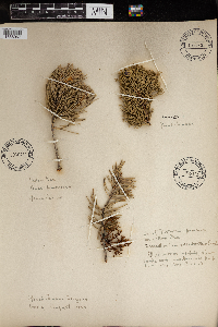 966430[1356967] 1925-08-00 United States, Arizona, Grand Canyon |
MIN:Plants |  966062[1356822] United States, Yellowstone National Park, 44.426573 -110.467041 |
MIN:Plants | Taxodium distichum (L.) richard 459656[]US Nat. Arboretum staff 1651974-00-00 United States, District of Columbia, [US Natl.] Arboretum. cult. |
MIN:Plants | Taxodium distichum (L.) richard 459658[]US Nat. Arboretum staff 2101978-00-00 United States, Virginia, James City, James City County |
MIN:Plants | 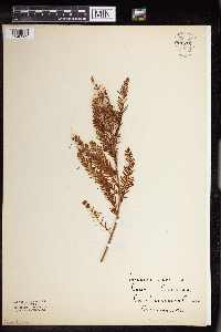 Taxodium distichum (L.) richard 961856[1340363] United States, California |
MIN:Plants | 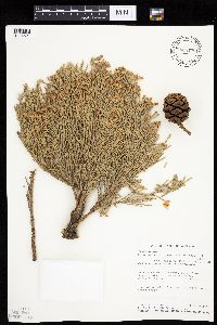 Sequoiadendron giganteum (Lindley) J. Buchholz 828490[1004521]Miller, James; et al. 81001993-06-04 United States, California, Fresno, Sierra National Forest, 16 mi E of Shaver Lake on Dinkey Creek road;;;;, 37.05 -119.15 |
MIN:Plants | Sequoiadendron giganteum (Lindley) J. Buchholz 232967[]Congdon, J. s.n.1888-05-27 United States, California, Mariposa, Big Tree Grove;Yosemite National Park |
MIN:Plants | Sequoiadendron giganteum (Lindley) J. Buchholz 232971[]Congdon, J. s.n.1882-11-00 United States, California, Mariposa, Big Tree Grove;Yosemite National Park |
MIN:Plants | Sequoiadendron giganteum (Lindley) J. Buchholz 357721[]Ericson, Mildred J. s.n.1939-07-06 United States, California, Mariposa, Yosemite National Park, Mariposa grove of Big Trees, 1981m |
MIN:Plants | Sequoiadendron giganteum (Lindley) J. Buchholz 562250[]Norris, Richard E. s.n.1959-11-00 United States, California, Sequoia National Park |
MIN:Plants | Sequoiadendron giganteum (Lindley) J. Buchholz 372740[]Muenscher, W. C. 149251939-03-20 United States, California, Tulare, Sequoia National Park, 2073m |
MIN:Plants | Sequoiadendron giganteum (Lindley) J. Buchholz 232965[]Congdon, J. W. s.n.1891-07-28 United States, California, Mariposa, Soda Spring, Wawona [Yosemite National Park] |
MIN:Plants | Sequoiadendron giganteum (Lindley) J. Buchholz 601087[]Munns, C. E. 3411966-03-24 United States, California |
MIN:Plants | Sequoiadendron giganteum (Lindley) J. Buchholz 354080[]Buchholz, J. T. s.n.1936-04-28 United States, California, Sequoia National Park, from trees near General Grant tree - Lafayette tree or one nearby. |
MIN:Plants | Sequoiadendron giganteum (Lindley) J. Buchholz 297690[]Bracelin, Mrs. H. P. 7171932-09-09 United States, California, Tulare, Sequoia National Park |
MIN:Plants | Sequoiadendron giganteum (Lindley) J. Buchholz 403923[]Wadmond, S. C. s.n.1915-06-30 United States, California, Mariposa, Mariposa Grove, Yosemite Valley. From Grissly Giant. [Yosemite National Park] |
MIN:Plants | Sequoiadendron giganteum (Lindley) J. Buchholz 541783[]Buchholz, J. T. s.n.1936-04-30 United States, California, Sequoia National Park, Gen. Grant area, 2030m |
MIN:Plants | Sequoiadendron giganteum (Lindley) J. Buchholz 232993[]Bondshee, F. A. s.n.1903-04-27 United States, California, Mariposa, Big Tree Grove [Yosemite National Park] |
MIN:Plants | Sequoiadendron giganteum (Lindley) J. Buchholz 240280[]Bondshee, F. A. s.n.1903-04-27 United States, California, Mariposa, Big Tree Grove [Yosemite National Park] |
MIN:Plants | Sequoia sempervirens (D. Don) Endlicher 492446[]Williams, M. s.n.1983-00-00 United States, California, Contra Costa, Orinda, Contra Costa Co. |
MIN:Plants | 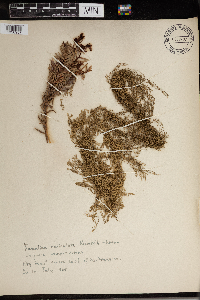 Sequoia sempervirens (D. Don) Endlicher 966420[1356957] 1925-07-00 United States, California, Big Trees region south of San Francisco |
MIN:Plants | 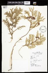 432065[1004550]Bolin, Kathy 24 KEB1987-04-08 United States, Minnesota, Winona, Winona Co.; T: 106N R: 06W Sec: 12 Quarter sec: NE NE;Dorer Memorial Hardwood State Forest;106N;06W;12, 43.998451 -91.490397 |
MIN:Plants | 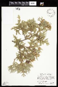 429123[1004535]Smith, Welby 289202000-08-08 United States, Minnesota, Lake, Lake County ... Tettegouche State Park, about one mile west of Illgen City ...T56N R7W NW1/4 of SE1/4 of Sec 10;North Shore / Tettegouche State Park;056N;07W;10, 47.3463898 -91.2050018 |
MIN:Plants | 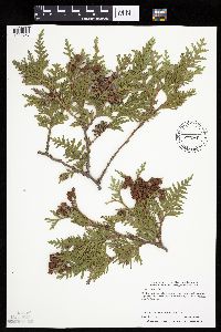 429264[1004570]Lake, Roger 98-51998-10-17 United States, Minnesota, Saint Louis, St. Louis County ... T 59N R 21W SW1/4 of SW1/4 of Sec 2;Superior National Forest;059N;21W;02, 47.624451 -92.964959 |
MIN:Plants | 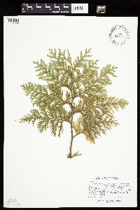 477495[1004605]Lee, Michael MDL15571996-09-11 United States, Minnesota, Carlton, Carlton County ... cliff along the St. Louis River gorge immediately downstream from the Thomson dam, just above the HWY 210 bridge ... T48N R16W SE1/4 SE1/4 Sec. 6. 048N 16W 6, 46.665069 -92.409257 |
MIN:Plants | 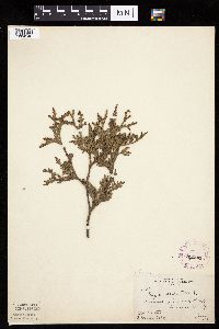 262281[1004546]Butters, F.; et al. 42571922-06-00 United States, Minnesota, Winona, Summit of Gwinn's Bluff, Winona Co.;Great River Bluffs State Park;106N;05W;, 44.049963 -91.639315 |
MIN:Plants | 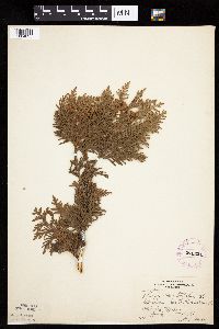 276821[1004635]Huff, N. 1671914-07-14 United States, Minnesota, Lake, South Kawishiwi Riv. Lake Co.;Superior National Forest;N;;, 47.824084 -91.725158 |
MIN:Plants | 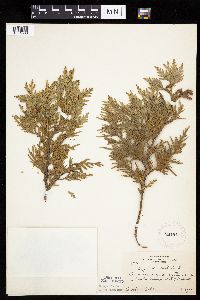 281911[1004538]Rosendahl, C. 64201931-08-13 United States, Minnesota, Anoka, N border of Anoka Co, E of Bethel;;034N;23W;, 45.38975 -93.250219 |
MIN:Plants | 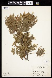 282813[1004603]Butters, F.; Buell, Murray 4731932-07-18 United States, Minnesota, Cook, N shore of Clearwater Lake, Cook Co, T65N, R1E;Boundary Waters Canoe Area Wilderness / Superior National Forest;065N;01E;, 48.087449 -90.322587 |
MIN:Plants | 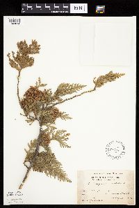 289546[1004624]Lakela, Olga 7141933-08-18 United States, Minnesota, Clearwater, Itasca Park. Garrison Point.;Itasca State Park;143N;36W;, 47.197458 -95.201964 |
MIN:Plants | 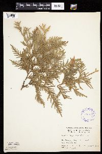 292028[1004543]Moyle, J. 6971933-06-30 United States, Minnesota, Clearwater, Itasca Park. Clearwater Co. NW-NW-11 T143 R36;Itasca State Park;143N;36W;11, 47.218013 -95.200853 |
MIN:Plants | 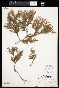 337697[1004577]Lakela, Olga 17011936-08-12 United States, Minnesota, Saint Louis, Center of ridge; Sec.18, Duluth;;N;;, 46.7833 -92.1 |
MIN:Plants | 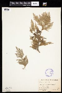 348005[1004542]Buell, Murray; Buell, Helen 6911933-08-03 United States, Minnesota, Anoka, Decodon Pond. Anoka Co.;Cedar Creek National History Area;034N;23W;, 45.40217 -93.199397 |
MIN:Plants | 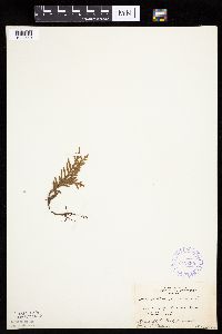 349290[1004540]Nielsen, E. 24731934-05-31 United States, Minnesota, Clearwater, Bohall Trail, Itasca State Park;Itasca State Park;143N;36W;, 47.197458 -95.201964 |
MIN:Plants | 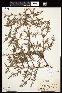 351329[1004617]Benner, F.; Benner, J. 4901929-07-27 United States, Minnesota, Cook, 3/4 mi E Grand Portage;Grand Portage Indian Reservation / North Shore;063N;06E;, 47.966438 -89.668123 |
MIN:Plants | 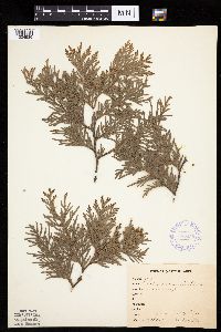 355456[1004539]Anonymous 221912-06-27 United States, Minnesota, Saint Louis, Meadowlands, St. Louis Co.;;N;;, 47.071884 -92.732416 |
MIN:Plants | 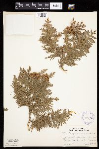 362082[1004544]Lakela, Olga 39321940-08-04 United States, Minnesota, Saint Louis, At Burntside Laek, Burntside Lodge, St. Louis Co.;;N;;, 47.8833 -91.9167 |
MIN:Plants | 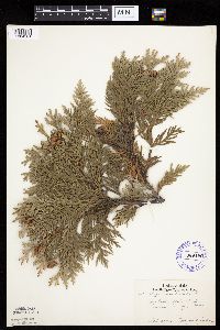 369190[1004581]Jackson, Margaret 5481939-09-23 United States, Minnesota, Carlton, Jay Cooke State Park, Carlton Co.;Jay Cooke State Park;048N;16W;, 46.649665 -92.330748 |
MIN:Plants | 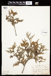 372409[1004557]Lakela, Olga 46071941-08-01 United States, Minnesota, Lake, Lake Superior near Knife River;North Shore;052N;11W;31, 46.946524 -91.794017 |
MIN:Plants | 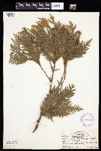 373240[1004533]Marr, J. T1831941-05-00 United States, Minnesota, Winona, Gwin's Bluff, Winona Co.;Great River Bluffs State Park;106N;05W;, 43.955293 -91.410815 |
MIN:Plants | 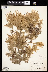 373743[1004572]Moore, John; et al. 150681941-08-08 United States, Minnesota, Cass, 13 mi N of Walker on U.S.371, Cass Co.;Chippewa National Forest / Leech Lake Indian Reservation;;;, 47.289533 -94.587216 |
MIN:Plants | 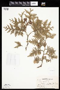 381175[1004595]Moore, John; et al. 152481942-05-24 United States, Minnesota, Lake of the Woods, Clementson, at mouth of Rapid River, E side, Lake of the Woods Co.;;160N;30W;, 48.690302 -94.439218 |
MIN:Plants | 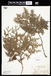 381629[1004548]Moore, John; et al. 152321942-05-23 United States, Minnesota, Beltrami, Blackduck River, crossing 1 mi S of Quiring, Beltrami Co.;;151N;32W;, 47.864041 -94.707347 |
MIN:Plants | 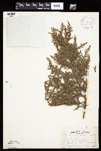 392983[1004611]Lakela, Olga 69691947-07-27 United States, Minnesota, Saint Louis, Henry Lakela's farm, Palo, St. Louis Co.;;057N;15W;, 47.415205 -92.259625 |
MIN:Plants | 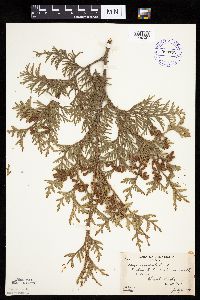 393777[1004594]Butters, F.; Abbe, E. 8001944-07-30 United States, Minnesota, Cook, Cook Co. S side of Birch Lake, T65N R1W;Superior National Forest;065N;01W;, 47.726653 -90.386005 |
MIN:Plants | 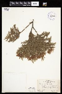 393794[1004593]Rosendahl, C.; Butters, F. 63121930-08-26 United States, Minnesota, Cook, E of Grand Portage, Cook Co.;Grand Portage Indian Reservation / North Shore;063N;06E;, 47.9667 -89.7667 |
MIN:Plants | 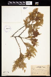 393795[1004636]Nielsen, E. 17121932-09-13 United States, Minnesota, Cook, Near lodge at Clearwater Lake, Cook Co.;Boundary Waters Canoe Area Wilderness / Superior National Forest;065N;01E;, 48.087449 -90.322587 |
MIN:Plants | 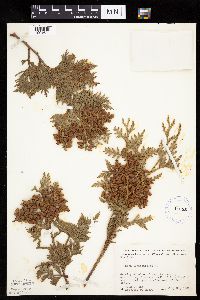 412351[1004620]Moore, John; Moore, Marjorie 110501939-07-21 United States, Minnesota, Lake of the Woods, Lake of the Woods Co. 1 mi up from the mouth of Pine Creek, Angle Inlet, 3/4 of a mi W of the creek;Northwest Angle;N;;, 49.346587 -95.047469 |
MIN:Plants | 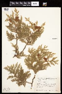 412397[1004619]Moore, John; Moore, Marjorie 116811939-08-12 United States, Minnesota, Koochiching, Koochiching Co. Growing in the vicinity of the Island View Hotel, T71, R22W, Sec.25; along S shore of Rainy Lake;Voyageurs National Park;071N;22W;25, 48.599102 -93.377757 |
MIN:Plants | 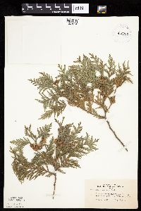 416750[1004614]Lakela, Olga 95721949-08-29 United States, Minnesota, Saint Louis, Near Gappas Landing, Lake Kabetogama, St. Louis Co.;Voyageurs National Park;N;;, 48.470908 -93.008801 |
MIN:Plants | 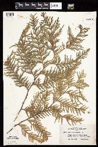 420707[1004574]Lakela, Olga 117161950-08-24 United States, Minnesota, Saint Louis, At Curtain Falls, Crooked Lake, St. Louis Co.;Boundary Waters Canoe Area Wilderness / Superior National Forest;066N;12W;, 48.230217 -91.917174 |
MIN:Plants | 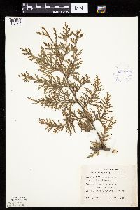 424062[1004547]Emanuel, J. 1361946-09-03 United States, Minnesota, Itasca, County: Itasca. Locality: Nashwauk Township;;057N;22W;00, 47.40917 -93.195 |
MIN:Plants | 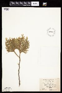 427890[1004613]Jones, George Neville 186071946-08-05 United States, Minnesota, Saint Louis, Lake Vermilion near Tower, St. Louis Co.;;N;;, 47.891581 -92.366824 |
MIN:Plants | 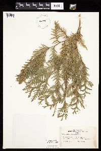 442811[1004615]Lakela, Olga 131491951-07-13 United States, Minnesota, Saint Louis, Dryweed Island in Rainy Lake, most NW corner of St. Louis Co.;Voyageurs National Park;N;;, 48.623498 -93.206383 |
MIN:Plants | 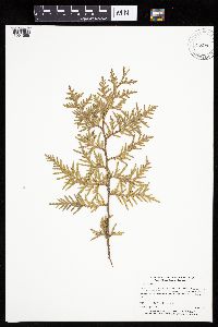 443876[1004585]Myhre, K. 51121994-06-30 United States, Minnesota, Itasca, Itasca Co.; Located one mile west of Middle Pigeon Lake; T 147N R 28W SE1/4 of NE1/4 of Sec 2;Chippewa National Forest / Leech Lake Indian Reservation;147N;28W;2, 47.580253 -94.185393 |
MIN:Plants | 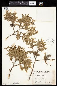 444939[1004573]Moore, John; Huff, N. 195781947-06-14 United States, Minnesota, Aitkin, Aitkin Co. 2 mi S of Hill City;Hill River State Forest;N;;, 46.957615 -93.603045 |
MIN:Plants | 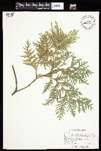 445247[1004571]Lee, Michael MDL14831996-08-15 United States, Minnesota, Saint Louis, St. Louis Co.; Fon [sic] du Lac State Forest 7 miles northeast of Cromwell; T49N R19W SW1/4 SE1/4 Sec. 5;Fond du Lac State Forest;049N;19W;5, 46.659664 -92.273248 |
MIN:Plants | 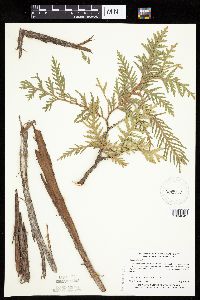 455952[1004642]Myhre, K. 1717A1992-05-07 United States, Minnesota, Cass, Cass Co.; located on the south side of Little Thunder Lake; T 140N R 26W SW1/4 of SW1/4 of Sec 2;;140N;26W;2, 46.964752 -93.940264 |
MIN:Plants | 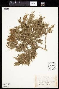 463346[1004578]Lakela, Olga 143091952-06-19 United States, Minnesota, Saint Louis, Gull Island in Namakan Lake 5 mi from the Narrows, St. Louis Co.;Voyageurs National Park;N;;, 48.433517 -92.705646 |
MIN:Plants | 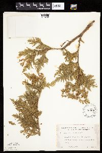 463431[1004602]Lakela, Olga 148381952-07-10 United States, Minnesota, Saint Louis, St. Louis Co. Island in Rainy Lake, off Dryweed Island, NW corner of the county;Voyageurs National Park;N;;, 48.623498 -93.206383 |
MIN:Plants | 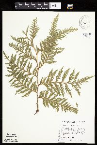 475834[1004637]Judziewicz, E. 107601993-09-01 United States, Minnesota, Washington, Washington Co.; T32N-R19W, Sec. 19, NW of SE; at the mouth of a small dolomite canyon about 1 km north of Copas.;Saint Croix Wildlife Management Area;032N;19W;19, 45.243569 -92.75992 |
MIN:Plants | 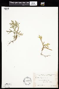 492946[1004527]Lakela, Olga 166701953-08-08 United States, Minnesota, Saint Louis, St. Louis Co. On Lac La Croix near Lac La Croix;Boundary Waters Canoe Area Wilderness / Superior National Forest;;;, 48.34361 -92.12278 |
MIN:Plants | 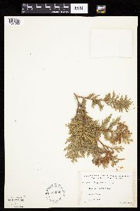 492986[1004592]Lakela, Olga 166431953-08-06 United States, Minnesota, Saint Louis, Coleman Island, Lac La Croix;Boundary Waters Canoe Area Wilderness / Superior National Forest;N;;, 48.3333 -92.1167 |
MIN:Plants | 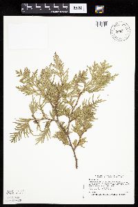 504980[1004643]Smith, Welby 191561991-07-08 United States, Minnesota, Koochiching, Franz Jevne State Park. Koochiching County...Franz Jevne State Park, in the Rainy River Valley, about 2 mi NE of Birchdale... T160N R27W SW1/4 of SW1/4 of Sec 26. 160N 27W 26, 48.6427765 -94.078331 |
MIN:Plants | 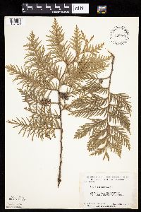 507400[1004530]Moore, John; et al. 209701951-06-07 United States, Minnesota, Itasca, Itasca County...Coon Lake, Scenic State Park.;Scenic State Park;060N;25W;, 47.723007 -93.563738 |
MIN:Plants |  525971[1004612]Lakela, Olga 190631955-08-03 United States, Minnesota, Saint Louis, St. Louis Co. Johnson's Lake S of Namakan Lake, R68 T18;Superior National Forest;068N;18W;, 48.433517 -92.705646 |
MIN:Plants |  527063[1004583]Lakela, Olga 176211954-06-24 United States, Minnesota, Saint Louis, St. Louis Co. Gregory Island in Burntside Lake;Superior National Forest;063N;13W;00, 47.9357 -91.982299 |
MIN:Plants |  541519[1004532]Morley, T. 9211957-05-26 United States, Minnesota, Pine, Pine Co. W bank of Kettle River ca. 2 mi S of bridge of state hwy.23 near NE limits of town of Sandstone;Banning State Park;N;;, 46.145255 -92.860815 |
MIN:Plants |  542507[1004575]Moore, John 216231952-05-23 United States, Minnesota, Cass, Cass Co. E shore of Steamboat Lake;Leech Lake Indian Reservation / Welsh Lake State Forest;144N;31W;, 47.018335 -94.573107 |
MIN:Plants |  543001[1004576]Lakela, Olga 215921957-07-25 United States, Minnesota, Lake, Lake Co. Isabella River at bridge of Tomahawk Trail;Superior National Forest;N;;, 47.800713 -91.52116 |
MIN:Plants |  565146[1283442]Cotter, Shirley 3771948-07-28 United States, Minnesota, Clearwater, Clearwater Co. Itasca Park, grounds of [Univ. of] Minn. Biol. station;Itasca State Park;143N;36W;, 47.197458 -95.201964 |
MIN:Plants |  56741[1004525]Rosendahl, C. 23651909-08-28 United States, Minnesota, Otter Tail, Region of Pelican Lake;;;;, 46.69944 -96.02028 |
MIN:Plants |  56756[1283449]Butters, F. s.n.1918-05-31 United States, Minnesota, Carlton, Carlton Co.;;N;;, 46.592401 -92.677053 |
MIN:Plants | 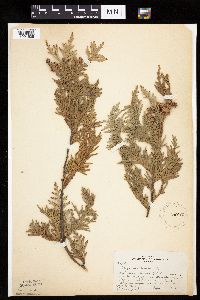 56757[1004528]Butters, F.; et al. 33921916-09-05 United States, Minnesota, Kanabec, 6 mi E of Mora, Kanabec Co.;;039N;23W;, 45.876835 -93.169052 |
MIN:Plants | 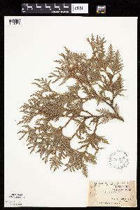 56758[1004616]Arthur, J.; et al. B1331886-07-20 United States, Minnesota, Saint Louis, Vermilion Lake;;;;, 47.89167 -92.36667 |
MIN:Plants | 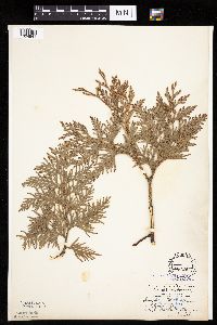 56759[1004541]Aiton, G. s.n.1891-07-00 United States, Minnesota, Clearwater, Lake Itasca;Itasca State Park;143N;36W;, 47.197458 -95.201964 |
MIN:Plants | 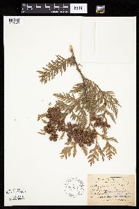 56760[1004626]Sandberg, John s.n.1891-06-00 United States, Minnesota, Itasca, Pokegama Lake;;N;;, 47.188454 -93.589294 |
MIN:Plants | 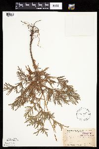 56763[1004630]Arthur, J.; et al. B831886-07-00 United States, Minnesota, Saint Louis, Vermilion Lake;;;;, 47.891581 -92.366824 |
MIN:Plants | 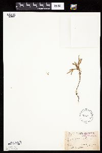 56765[1004529]Arthur, J.; et al. B3811886-07-24 United States, Minnesota, Saint Louis, Mud L. Vermilion Lake;;062N;14W;03, 47.881086 -92.104431 |
MIN:Plants | 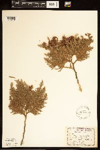 56766[1283440]Leonard, W. 281875-09-00 United States, Minnesota, Carlton, Dalles of the St. Louis;Jay Cooke State Park;048N;16W;, 46.649665 -92.330748 |
MIN:Plants | 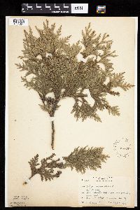 56767[1004601]Rosendahl, C. 38341919-08-01 United States, Minnesota, Winona, Ledges 400-450 ft above river level, Gwinn's Bluff, Winona Co.;Great River Bluffs State Park;106N;05W;, 43.946353 -91.399309 |
MIN:Plants | 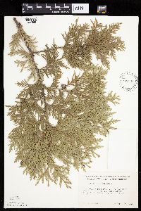 570344[1004566]Morley, T. 10011963-09-30 United States, Minnesota, Washington, Washington Co. St. Croix River. T32N, R19W, sec.7, NW1/4 NE1/4;;032N;19W;7, 45.279436 -92.761183 |
MIN:Plants | 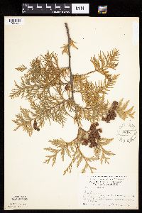 574981[1004631]Wertman, Freida 3641960-10-07 United States, Minnesota, Anoka, Cedar Creek National History Area. Anoka Co. Cedar Creek Natural History Area. Laboratory environs. Sec.27 s.w.; Co.Rd.24; Athens Twp. Sec.27; Coordinates, Anoka Co. Cedar Creek Natural History Area. Laboratory environs. Sec.27 s.w.; Co.Rd.24; Athens Twp. Sec.27; Coordinates, 876.3-2205.3. 034N 23W 27, 45.314148 -93.324227 |
MIN:Plants | 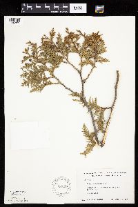 583233[1004625]Kellner, H. 4171956-07-25 United States, Minnesota, Cook, Cook Co.; Lake Superior. Grand Portage.;Grand Portage Indian Reservation / North Shore;063N;06E;, 47.9667 -89.7667 |
MIN:Plants | 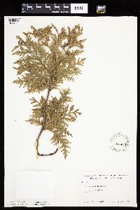 583433[1004588]Kellner, H. 4821956-07-20 United States, Minnesota, Cook, Cook County...Atop Mt. Josephine. Grand Portage.;Grand Portage Indian Reservation / North Shore;064N;06E;34, 47.98333 -89.65917 |
MIN:Plants | 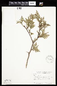 583462[1004589]Kellner, H. 3191956-08-14 United States, Minnesota, Lake, Lake Co. At station 6, Shovel Pt. site.;North Shore / Tettegouche State Park;056N;07W;14, 47.33958 -91.198054 |
MIN:Plants | 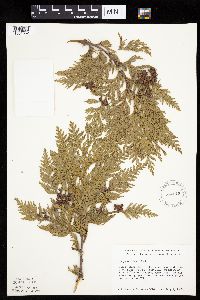 584515[1004552]Ownbey, Gerald 35281963-07-02 United States, Minnesota, Clearwater, Itasca State Park. Clearwater Co. Itasca State Park. Lake Itasca near [Univ. of Minn.] Biol. Sta. T143N, R36W, NE1/4 Sec.11. On NE side of Clearwater Co. Itasca State Park. Lake Itasca near [Univ. of Minn.] Biol. Sta. T143N, R36W, NE1/4 Sec.11. On NE side of Floating Bog Bay. 143N 36W 11, 47.218013 -95.200853 |
MIN:Plants | 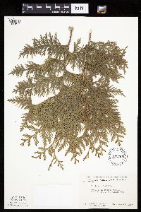 603765[1004622]Moore, John; Dorn, Robert 270861967-05-29 United States, Minnesota, Winona, Winona Co. Gilmore Valley, SE1/4, Sec.31, Winona Twp.;;107N;07W;31, 43.9833 -91.7 |
MIN:Plants | 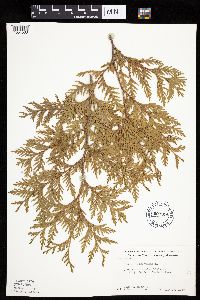 603814[1004568]Moore, John; Dorn, Robert 270541967-05-27 United States, Minnesota, Houston, Houston Co. NW1/4, Sec.8, Sheldon Twp.;Dorer Memorial Hardwood State Forest;103N;06W;8, 43.742219 -91.58636 |
MIN:Plants | 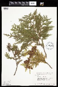 604003[1004621]Moore, John; Moore, Marjorie 272351967-09-22 United States, Minnesota, Anoka, Anoka Co. Along the S side of Cedar Bog Lake, Cedar Creek Natural History Area;Cedar Creek National History Area;034N;23W;, 45.40217 -93.199397 |
MIN:Plants | 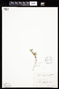 611449[1004634]Lammers, Roberta s.n.1967-07-28 United States, Minnesota, Anoka, Anoka Co. SW of Cedar Bog Lake, Cedar Creek Natural History Area;Cedar Creek National History Area;034N;23W;, 45.40217 -93.199397 |
MIN:Plants | 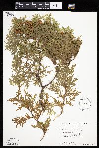 616502[1004591]Moore, John; Moore, Marjorie 3141969-07-22 United States, Minnesota, Crow Wing, Crow Wing Natural History Area. Crow Wing Co. E side of Chandler Lake, SW1/4, Sec.22, Garrison Twp.;Crow Wing Natural Area;044N;28W;22, 46.278961 -93.86289 |
MIN:Plants | 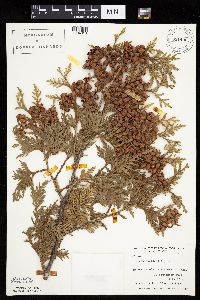 631490[1004618]Richards, Donald; et al. 18461971-09-10 United States, Minnesota, Itasca, Itasca County...N shore of lake. Deer Lake, 18 mi NW of Grand Rapids;;;;, 47.37852 -93.66181 |
MIN:Plants |  679053[1004600]Ownbey, Gerald 50261975-07-25 United States, Minnesota, Cook, Cook County...Grand Portage. At and near summit of Mt. Josephine.;Grand Portage Indian Reservation / North Shore;T064N R06E S34, 47.983098 -89.662439 |
MIN:Plants |  679105[1004536]Newcomb, Eloise 1131941-05-25 United States, Minnesota, Isanti, Isanti Co. Cedar Creek Bog;Cedar Creek National History Area;034N;23W;, 45.436188 -93.188184 |
MIN:Plants |  686810[1004531]Wheeler, Gerald; Glaser, Paul 12361977-05-14 United States, Minnesota, Itasca, Itasca Co. Coll. Site #1. SE1/4 SE1/4 Sec.19 T56N R26W; approx. 10 mi NW of Grand Rapids.;;056N;26W;19, 47.312586 -93.684586 |
MIN:Plants |  691286[1004632]Lightfoot, J. s.n.1977-08-19 United States, Minnesota, Cook, Cook Co. SW1/4 of the SE1/4 Sec.31, T60 R4;North Shore / Superior National Forest;T60N R04W S31, 47.637604 -90.884278 |
MIN:Plants | 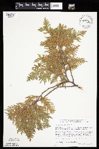 698396[1004587]Wheeler, Gerald; Glaser, Paul 31971978-07-13 United States, Minnesota, Beltrami, Approx. 20.5 mi northwest of the Waskish Airport. Western Water Track. Coll. Site No. 54. NE1/4 NW1/4 of section;Red Lake Peatland Scientific Natural Area;155N;33W;05, 48.27839 -94.917974 |
MIN:Plants | 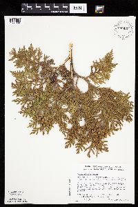 698431[1004639]Wheeler, Gerald; Glaser, Paul 32321978-07-15 United States, Minnesota, Beltrami, Red Lake Indian Reservation. Beltrami Co. NE1/4 SE1/4 Sec.10 T156N R32W; approx. 16.5 mi NW of the Waskish Airport. Western Edge of Ovoid Islands Are Beltrami Co. NE1/4 SE1/4 Sec.10 T156N R32W; approx. 16.5 mi NW of the Waskish Airport. Western Edge of Ovoid Islands Area; about 0.75 mi N-NW of Camp No.II. Coll. Site #62. 156N 32W 10, 48.014981 -95.229776 |
MIN:Plants |  699102[1004586]Sather, Nancy; et al. 4981977-08-17 United States, Minnesota, Saint Louis, St. Louis Co. Dunka mine contaminated bog. E1/2, SE1/4, S3, T60N, R12W;Superior National Forest;T060N R12W S03, 47.708862 -91.85157 |
Google Map
Google Maps is a web mapping service provided by Google that features a map that users can pan (by dragging the mouse) and zoom (by using the mouse wheel). Collection points are displayed as colored markers that when clicked on, displays the full information for that collection. When multiple species are queried (separated by semi-colons), different colored markers denote each individual species.