University of Minnesota
http://www.umn.edu/
612-625-5000
http://www.umn.edu/
612-625-5000
Minnesota Biodiversity Atlas
Bell Museum
Dataset: MIN-Plants
Taxa: Cyatheaceae
Search Criteria: excluding cultivated/captive occurrences
Bell Museum plants | |
 MIN:Plants | 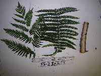 951711[1297713]Weiblen, G.D. YS2J00752012-11-14 Papua New Guinea, Morobe, Yawan Village, -6.164683 146.841717, 1855m |
MIN:Plants |  570415[1321349]Tucker, S.C. 1959-05-05 United States, Minnesota, Hennepin, cultivated, 45.004284 -93.233154 |
MIN:Plants |  54308[1321350]Pollard, C.L. 2551902-02-01 Cuba, Santiago, Vicinity of Baracoa |
MIN:Plants |  54309[1321356]Pringle, C.G. 81741899-04-19 Mexico, Vera Cruz, Near Jalapa, 1219m |
MIN:Plants |  521428[1321358]Moore, A. 1906-04-00 Jamaica, Chepstow, 18.178102 -76.635981 |
MIN:Plants |  54311[1321359]Clute, W.N. 3501900-03-07 Jamaica, Cuna-Cuna Gap, 762m |
MIN:Plants |  521427[1321360]Moore, A. 1906-01-00 Jamaica, Man Mountain, 18.144237 -77.294385 |
MIN:Plants |  346850[1321361]Senn, H.A. 2291938-03-21 Cuba, Santa Clara, Mina Carlota, south-east of Cumanayagua, Sierra de San Juan, 300 - 400m |
MIN:Plants |  775136[1321362]Lane, C. 34 United States, Puerto Rico, Car. Nat. Forest, 3/4 mile up service road to Mt. Britton |
MIN:Plants |  52800[1321373]Pollard, C.L. 1181902-01-30 Cuba, Slopes and summit of El Yunque, near Baracoa, 305 - 610m |
MIN:Plants |  450940[1321374]Blomquist, H.L. 116841941-08-31 Puerto Rico, Trail to Britton Tower, El Yunque Mt. |
MIN:Plants |  346848[1321375]Senn, H.A. 3871938-03-21 Cuba, Santa Clara, Mina Carlota, south-east of Cumanayagua, Sierra de San Juan, 300 - 400m |
MIN:Plants |  54397[1321376]Butler, Eloise 1891-07-00 Jamaica, Port Antonio |
MIN:Plants |  54806[1321377]Smith, H.H. 854 Saint Vincent and the Grenadines, St Vincent B.W.I., 13.604148 -61.039551 |
MIN:Plants |  52801[1321378]Pollard, C.L. 1541902-01-30 Cuba, Slopes and summit of El Yunque, near Baracoa, 305 - 610m |
MIN:Plants |  54398[1321379]Clute, W.N. 2661900-03-07 Jamaica, Cuna-Cuna Gap, 762m |
MIN:Plants |  521546[1321380]Moore, A. 1906-04-00 Jamaica, Chepstow, 18.178102 -76.635981 |
MIN:Plants |  54318[1321381]Smith, H.H. Saint Vincent and the Grenadines, St Vincent BWI [British West Indies], 13.604148 -61.039551 |
MIN:Plants |  426513[1321383]Glassman, S.F. 21041948-07-30 Honduras, Aqua Amarilla, along a waterfall; Drainage of the Rio Yeguare, 1158m |
MIN:Plants |  610718[1321385]Cornman, N.A. 6951918-01-27 Panama, Near Frijoles |
MIN:Plants |  54310[1321389]Smith, J.G. 801892-02-04 Mexico |
MIN:Plants |  426523[1321392]Glassman, S.F. 19431948-07-17 Honduras, Marazán, Mt. Uyuca, Drainage of the Rio Yeguare, 1920m |
MIN:Plants |  565500[1321393]York, H.H. 1651910-06-12 Jamaica, Morce's Gap |
MIN:Plants |  610722[1321396]Cornman, M. Alice 8961918-02-09 Panama, Dexter trail |
MIN:Plants |  521977[1321399]Moore, A. 1906-04-00 Jamaica, Chepstow, 18.178102 -76.635981 |
MIN:Plants |  54328[1321400]Curtiss, A.H. 3461904-02-15 Cuba, Near Nueva Gerona, Isla de Pinos, WI |
MIN:Plants |  927212[1321401;1321402;1321403]Smith, D.N. 64381984-03-21 Peru, Oxapampa, Villa Rica-Puerto Bermudez road, 15 km from Villa Rica |
MIN:Plants |  281209[1321406]Durand, E.J. Brazil, Rio |
MIN:Plants |  54317[1321407]Bang, A. Miguel 2425 Bolivia |
MIN:Plants |  938350[1321408]Vasquez, R. 170901991-07-07 Peru, Maynas, 150 - 180m |
MIN:Plants |  65267[1321409;1321410]Vasquez, R. 170901991-07-07 Peru, Maynas, 150 - 180m |
MIN:Plants |  925231[1321411]Pipoly, J. 159961991-11-15 Colombia, Amazonas, Amacayacu National Park, 200 - 220m |
MIN:Plants |  925250[1321414]Rueda, R.M. 141472000-07-15 Nicaragua, Matagalpa, Cerro Musún Nature Reserve, 500 - 1400m |
MIN:Plants |  54394[1321415]unknown 110 Venezuela, along Eleanor Creek |
MIN:Plants |  54395[1321416]unknown 384 Venezuela, Orinoco; Manoa |
MIN:Plants |  925252[1321417]Rueda, R.M. 145192000-08-26 Nicaragua, Jinotega, Cerro Kilambé Reserve, 950 - 1100m |
MIN:Plants |  278966[1321424]unknown s.n.1910-11-00 Brazil, Rio de Janeiro |
MIN:Plants |  281185[1321425]James, O.C. 1875-00-00 Brazil, near Rio |
MIN:Plants |  504938[1321426]Betancur, J. 12921989-08-10 Colombia, 3.263333 -74.285 |
MIN:Plants |  281191[1321427] 1870-07-28 Brazil, Rio |
MIN:Plants |  54323[1321443]Bang, A. Miguel 4841890-00-00 Bolivia, Yungas |
MIN:Plants |  54326[1321444] 1848 Bolivia |
MIN:Plants |  220366[1321445] 2206 Bolivia |
MIN:Plants |  54345[1321448] 5621890-00-00 Bolivia, Yungas |
MIN:Plants |  54313[1321461]Boorman, J. 1900-11-00 Indonesia, Labulam |
MIN:Plants |  54312[1321462] |
MIN:Plants |  54314[1321463]Armstrong, C.C. 1887-00-00 New Zealand, Vicinity of Dunedin |
MIN:Plants |  571137[1321465]Willa, E. 1958-11-00 New Zealand, Stewart Island. Halfmoon Bay |
MIN:Plants |  620672[1321475]Moore, John W. 4751927-01-01 French Polynesia, Society Islands, Raiatea, Mt. Temehani, -16.826331 -151.45229, 460m |
MIN:Plants |  349327[1321479]Topping, D.L. 11211909-01-23 Philippines, Pauai, Benguet, Luzon |
MIN:Plants |  54316[1321480] 40321883-03-00 India, 91 - 244m |
MIN:Plants |  54320[1321485]Scortechini, Rev. Father 2331884-03-00 Malaysia, Maxwell's Hill, 914m |
MIN:Plants |  54319[1321486] 73171885-03-00 Malaysia, 1372 - 1615m |
MIN:Plants |  54322[1321487]Maiden, J.H. 1902-03-00 Australia, Mt. Wilson |
MIN:Plants |  54321[1321488]Maiden, J.H. 1902-03-00 Australia, Mt. Wilson |
MIN:Plants |  617149[1321495]Doore, L.A. 3031935-02-16 New Zealand, Stewart Island, Oban. One mile northwest of Oban, along road to Horseshoe Bay |
MIN:Plants |  54400[1321496]Armstrong, C.C. 1887-00-00 New Zealand, Vicinity of Dunedin |
MIN:Plants |  571195[1321497]Willa, E. 1958-11-00 New Zealand, Stewart Island. Halfmoon Bay. |
MIN:Plants |  Cyathea magna Copel. 939841[1321490]Takeuchi, Wayne 74081991-08-15 Papua New Guinea, Near the Markham river, -6.75 147, 750m |
MIN:Plants |  Hemitelia raiateensis John W. Moore 620105[1001358]Moore, J.W. 1371926-09-25 French Polynesia, Society Islands, Raiatea, East path to Mt. Temehani., -16.827317 -151.453148, 360m |
MIN:Plants | 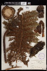 Cyathea affinis (G. Forst.) Sw. 289905[1293483]Grant, Martin L. 3526 French Polynesia, Society Islands, Tahiti, -17.633333 -149.45 |
MIN:Plants | 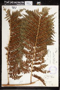 Cyathea affinis (G. Forst.) Sw. 289803[1321458] 53941931-02-18 French Polynesia, Afareaitui Putoa, -17.55 -149.783333, 347m |
MIN:Plants | 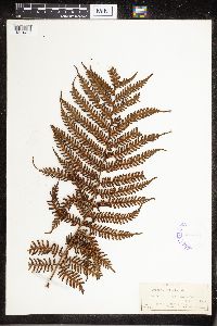 Cyathea affinis (G. Forst.) Sw. 417701[1321459] 1921-07-02 French Polynesia, Nukuhiva, Tovii, 1000m |
MIN:Plants | 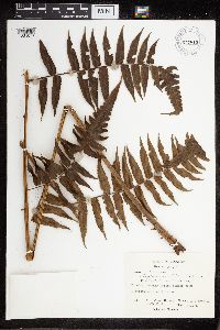 Cnemidaria C. Presl 677815[1321071]Warner, R.H. 1561973-08-03 Colombia, Chocó, Virudó; primary forest behind town, 0 - 100m |
MIN:Plants |  Cyathea arborea (L.) Sm. 54330[1321351]Clute, W.N. 2891900-03-07 Jamaica, 762m |
MIN:Plants |  Cyathea arborea (L.) Sm. 54329[1321352]Butler, Eloise 1891-07-00 Jamaica, Port Antonio |
MIN:Plants |  Cyathea arborea (L.) Sm. 54331[1321353]Pollard, C.L. 451902-01-24 Cuba, Santiago, Vicinity of Baracoa |
MIN:Plants |  Cyathea arborea (L.) Sm. 220482[1321354]Stevenson, J.A. 26941915-03-28 United States, Puerto Rico, Pueblo Viejo |
MIN:Plants |  Cyathea arborea (L.) Sm. 346849[1321355]Senn, H.A. 3861938-03-21 Cuba, Santa Clara, Mina Carlota, south-east of Cumanayagua, Sierra de San Juan, 300 - 400m |
MIN:Plants |  Cyathea cubensis Underw. ex Maxon 366509[1321357]Jack, J.G. 72411929-04-11 Cuba, Santa Clara, Buenos Aires, Trinidad Hills, 762 - 1067m |
MIN:Plants |  Cyathea cubensis Underw. ex Maxon 366149[1321363]Jack, J.G. 70021929-03-06 Cuba, Santa Clara, Buenos Aires, Trinidad Hills, 762 - 1067m |
MIN:Plants |  Cyathea divergens Kunze 923899[1321364]Solomon, J. 192081990-09-07 Costa Rica, 4 km W of Naranjo on Costa Rica Highway 10 (between Paraiso and Turrialba). Upper slope of Quebrada Honda, 9.816667 -83.783333, 1400m |
MIN:Plants |  Cyathea divergens Kunze 610725[1321365]Cornman, M. Alice 11541918-03-17 Panama, Lino hill, El Boquete |
MIN:Plants |  Cyathea elegans Heward 521429[1321366]Shreve, F. 1906-05-26 Jamaica, Hollymount |
MIN:Plants |  Cyathea elegans Heward 220373[1321367]Fuertes, M. 7421910-10-00 Dominican Republic, Barahona, 600m |
MIN:Plants |  Cyathea furfuracea Baker 243105[1321368] C152641915-02-24 Jamaica, Cinchona, Blue Mountains |
MIN:Plants |  Cyathea furfuracea Baker 243104[1321369]Harris, J.A. C152511915-02-24 Jamaica, Cinchona , Blue Mountains |
MIN:Plants |  Cyathea furfuracea Baker 54337[1321370]Clute, W.N. 891900-02-06 Jamaica, Morce's Gap, 1524m |
MIN:Plants |  Cyathea gracilis Griseb. 54338[1321371]Clute, W.N. 1811900-02-15 Jamaica, Morce's Gap, 1524m |
MIN:Plants |  Cyathea grevilleana Mart. 54339[1321372]Pollard, C.L. 1531902-01-30 Cuba, Slopes and summit of El Yunque, near Baracoa, 305 - 610m |
MIN:Plants |  Cyathea insignis D.C.Eaton 220372[1321382]Fuertes, M. 10581911-09-00 Dominican Republic, Barahona |
MIN:Plants |  Cyathea muricata Willd. 54341[1321384]von Turckheim, H. 30561910-03-00 Dominican Republic |
MIN:Plants |  Cyathea pilosissima Domin. 331980[1321386;1321387]Vasquez, R. 181331992-03-24 Peru, Maynas, -4.166667 -73.5, 150m |
MIN:Plants |  Cyathea pilosissima Domin 485108[1321429;1321430;1321431;1321432;1321433;1321434;1321435;1321436;1321437]Vasquez, R. 163571991-05-23 Peru, Maynas, Iquitos, Allpahuayo. Estación Experimental del Instituto de Investigaciones de la Amazonia Peruana (IIAP), 150 - 180m |
MIN:Plants |  Cyathea pilosissima Domin. 485098[1321438;1321439;1321440]Vasquez, R. 163971991-05-24 Peru, Maynas, Iquitos, Allpahuayo, Estación Experimental del Instituto de Investigaciones de la Amazonia Peruana (IIAP), 150 - 180m |
MIN:Plants |  Cyathea pilosissima Domin. 515094[1321441]van der Werff, H. 139441996-03-20 Peru, Maynas, Explor Napo Camp at Rio Sucusari, along boundary trail, 120m |
MIN:Plants |  Cyathea pilosissima Domin. 515491[1321442]van der Werff, H. 139321996-03-19 Peru, Maynas, Xplor Napo Camp at Rio Sucusari, along boundary trail, 120m |
MIN:Plants |  54399[1321388]Kuhn, M. 61581887-02-08 Puerto Rico |
MIN:Plants |  Cyathea pubescens Kuhn 54343[1321390]Clute, W.N. 901900-02-06 Jamaica, Morce's Gap, 1524m |
MIN:Plants |  Cyathea pubescens Kuhn 54342[1321391]Kuhn, M. 14801885-07-14 United States, Puerto Rico, Sierra de Luquillo |
MIN:Plants |  Cyathea schanschin Mart. 54344[1321394]Pringle, C.G. 60881895-01-26 Mexico, Vera Cruz, Wooded hills above Orizaba, 1311m |
MIN:Plants |  Cyathea schanschin Mart. 54334[1321450]unknown s.n. [no data] |
MIN:Plants |  Cyathea schanschin Mart. 220349[1321451]Bang, A. Miguel 2318 Bolivia |
MIN:Plants |  Cyathea serra Willd. 54346[1321395]von Turckheim, H. 141909-12-00 Dominican Republic |
MIN:Plants |  Cyathea tussacii Desv. 54347[1321397]Clute, W.N. 1641900-02-13 Jamaica, Moody's Gap, 914m |
MIN:Plants |  Cyathea werckleana Christ 610727[1321398]Cornman, M. Alice 13591918-04-20 Panama, Holcomb trail, El Boquete |
MIN:Plants |  281242[1321404]Durand, E.J. Brazil |
MIN:Plants |  Cyathea andina Domin 482210[1321405]Ramirez, J.G. 11301987-06-25 Colombia, Antioquia, Quebrada "La Cristalina". Sector SE, 550 - 770m |
MIN:Plants |  Cyathea delgadii Sternb. 897945[1321412;1321413]Smith, D.N. 65571984-03-29 Peru, Satipo, Gran Pajonal: between Paucarete and Tihuanaski, -10.75 -74.383333, 1200m |
MIN:Plants |  Cyathea lasiosora Domin 427575[1321418;1321419;1321420;1321421;1321422;1321423]Vasquez, R. 165021991-05-25 Peru, Maynas, Loreto, Iquitos. Allpahuayo. Estación Experimental del Instituto de Investigaciones de la Amazonia Peruana (IIAP); (Quebrada Brashico), -4.166667 -73.5, 150 - 180m |
Google Map
Google Maps is a web mapping service provided by Google that features a map that users can pan (by dragging the mouse) and zoom (by using the mouse wheel). Collection points are displayed as colored markers that when clicked on, displays the full information for that collection. When multiple species are queried (separated by semi-colons), different colored markers denote each individual species.