University of Minnesota
http://www.umn.edu/
612-625-5000
http://www.umn.edu/
612-625-5000
Minnesota Biodiversity Atlas
Bell Museum
Dataset: MIN-Plants
Taxa: Dioscoreaceae
Search Criteria: excluding cultivated/captive occurrences
1
Page 1, records 1-22 of 22
Bell Museum plants | |
 MIN:Plants | 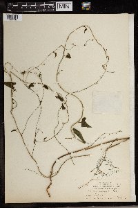 91341[1369143]Cook, Alice Carter 10701897-11-00 Spain, The Canary Islands. Teneriffe: Laguna |
MIN:Plants | 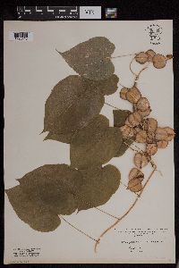 954162[1295715]Wible, Paul G. s.n.1928-07-26 United States, Indiana, Lawrence |
MIN:Plants | 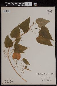 954163[1295714]Wible, Paul G. s.n.1928-00-00 United States, Indiana, Lawrence |
MIN:Plants | 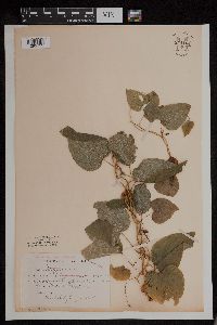 954164[1295713]Jenkins, F. E. s.n.1894-07-04 United States, Illinois, Montgomery |
MIN:Plants | []Timothy J. S. Whitfeld 32572022-07-01 United States, Minnesota, Washington, Crystal Spring Scientific and Natural Area, 0.4 miles northeast of the intersection of Scandia Trail North and Hwy 95, 45.260999 -92.768259, 276m |
MIN:Plants | 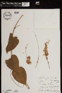 701809[1299437]Taylor, John 179921974-12-31 Costa Rica, San Jose, hillside just above the Rio Hondura at Baja La Hondura, 1150m |
MIN:Plants | 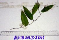 913343[]Weiblen, G. D. & Binatang Research Center WS1B22412006-07-18 Papua New Guinea, Madang, Wanang Village, -5.229583 145.178467, 115m |
MIN:Plants | 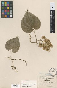 Dioscorea cyphocarpa Robinson ex Knuth 91260[1000828]Pringle, C.G. 103391906-10-13 Mexico, Guerrero, Iguala Canyon, 2438m |
MIN:Plants | 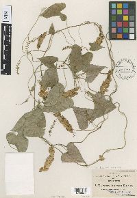 Dioscorea hirsuticaulis Robinson 91271[1000829]Pringle, C.G. 45721893-10-14 Mexico, Jalisco, Barranca of Tequila |
MIN:Plants |  Dioscorea minima Robinson & Seaton 91284[1000832]Pringle, C.G. 41571892-07-28 Mexico, Michoacan, Lava beds near Patzcuaro |
MIN:Plants |  Dioscorea platycolpota Uline 91281[1000833]Pringle, C.G. 92241900-09-15 Mexico, Guerrero, Near Iguala, 2438m |
MIN:Plants |  Dioscorea plumifera Robinson 91282[1000834]Pringle, C.G. 45301893-10-14 Mexico, Jalisco, Barranca of Tequila |
MIN:Plants |  Dioscorea pringlei Robinson 91283[1000835]Pringle, C.G. 45261893-09-07 Mexico, Jalisco, Barranca near Guadalajara |
MIN:Plants |  Dioscorea igualamontana Matuda 558879[1000830]Pringle, C.G. 103891907-07-29 Mexico, Guerrero, Iguala Canyon, 914m |
MIN:Plants |  Dioscorea ulinei Greenman ex R. Knuth 91295[1000836]Pringle, C.G. 65581896-09-18 Mexico, Morelos, Barranca above Cuernavaca |
MIN:Plants |  91265[1000826]Pringle, C.G. 48901894-09-10 Mexico, Oaxaca, Sierra de San Felipe |
MIN:Plants |  Dioscorea coripatensis Macbride 91254[1000827]Bang. M. 23341894-06-25 Bolivia, Coripati, Yungas |
MIN:Plants |  Dioscorea urceolata var. reflexa Greenman in Kunth 91296[1000837]Pringle, C.G. 64951896-09-13 Mexico, Morelos, Lava beds near Cuernavaca, 1585m |
MIN:Plants |  91273[1000831]Pringle, C.G. 73411896-09-13 Mexico, Morelos, Lava fields near Cuernavaca, 1524m |
MIN:Plants |  Dioscorea crinita Hook. f. 91255[1369140]Wood, J.M. 16181887-00-00 South Africa, Durban, 150m |
MIN:Plants |  Dioscorea dumetorum (Kunth) Pax 91264[1369141]Preuss 1385 Cameroon |
MIN:Plants |  Dioscorea dumetorum (Kunth) Pax 91263[1369142]Preuss 1385 Cameroon |
1
Page 1, records 1-22 of 22
Google Map
Google Maps is a web mapping service provided by Google that features a map that users can pan (by dragging the mouse) and zoom (by using the mouse wheel). Collection points are displayed as colored markers that when clicked on, displays the full information for that collection. When multiple species are queried (separated by semi-colons), different colored markers denote each individual species.