University of Minnesota
http://www.umn.edu/
612-625-5000
http://www.umn.edu/
612-625-5000
Minnesota Biodiversity Atlas
Bell Museum
Dataset: MIN-Plants
Taxa: Droseraceae
Search Criteria: excluding cultivated/captive occurrences
Bell Museum plants | |
 MIN:Plants |  907636[1345904]Tilden, Josephine E. 9871912-10-00 Australia, Grampian Mts., -20.416667 143.316667 |
MIN:Plants |  515365[1345439]Lee, Michael MDL37362004-07-21 United States, Minnesota, Becker, Two Inlets State Forest. BECKER COUNTY ... Two Inlets State Forest. four miles south of Two Inlets ... One Acre Lake ... T141N R36W SE1/4 of SW1/4 Sec.26. 141N 36W 26, 46.99982 -95.201476 |
MIN:Plants |  456501[1345453]Lee, Michael MDL22651998-07-20 United States, Minnesota, Wright, Wright Co.; adjacent to Stanley Eddy County Park 3 miles south-southwest of South Haven; T121N R28W SE1/4 of NE1/4 of SW1/4 Sec. 32. 121N 28W 32, 45.246611 -94.2305 |
MIN:Plants |  491251[1345525]Whitfeld, T.J.S. 4212003-06-11 United States, Minnesota, Douglas, Douglas County ... 4 miles northwest of Miltona; 3/4 mile east of State Hwy 29; 1/4 mile east of Parkers road ... T130N R37W NEJE 4. 130N 37W 4, 46.099916 -95.344347 |
MIN:Plants |  430211[1311732]Lee, Michael; et al. MDL18371997-07-17 United States, Minnesota, Meeker, Meeker Co.; In the extreme northeastern corner of the county between Lake etsy and Scott lake. 2-1/2 miles southeast of Kimball; T121N R29W SE1/4 of NW1/4 of NE1/4 Sec. 24. 121N 29W 24, 45.276311 -94.271391 |
MIN:Plants |  480641[1345533]Whitfeld, T.J.S. 2382001-06-12 United States, Minnesota, Kandiyohi, Kandiyohi County ... 1 mile north east of New London, 1/4 mile east of Co. Hwy. 9, just north of 198 Av. NE ... T 121N R 34W SW1/4 of NE1/4 of SE1/4 of Section 3. 121N 34W 3, 45.318683 -94.937712 |
MIN:Plants |  505360[1345442]Rowe, Erika ERR332004-07-23 United States, Minnesota, Becker, Becker County...2-1/2 miles east of Co. Hwy 34; 1/2 mile south of Big Rat Lake...T142N R39W SWSE 30;White Earth Indian Reservation;142N;39W;30, 47.085467 -95.668389 |
MIN:Plants |  910571[1345436]Lee, Michael MDL44582007-07-15 United States, Minnesota, Cass, Pillsbury State Forest. Cass County...Pillsbury State Forest. Along County Highway 1 on the east side of Rock Lake, seven miles north of Pillager...T134N R30W W1/2 of NW1/4 of NE1/4 Sec. 16...UTM: 5142423N 387464E. 134N 30W 16, 46.41985 -94.465203 |
MIN:Plants |  600710[1345441]Baker, Gary; Baker, Patricia 25301962-08-04 United States, Minnesota, Saint Louis, St. Louis County...About 1.6 miles north of Rollins;Cloquet Valley State Forest;055N;12W;03, 47.277884 -91.845111 |
MIN:Plants |  908380[1345437]Smith, Welby 245181994-06-29 United States, Minnesota, Polk, Polk County...Rydell National Wildlife Refuge, about 3 miles southeast of Mentor...T 148N R 43W NW1/4 of SE1/4 of Sec 2;Rydell National Wildlife Refuge;148N;43W;02, 47.6625 -96.0977778 |
MIN:Plants |  482216[1345451]Lee, Michael MDL23551998-08-06 United States, Minnesota, Stearns, Stearns Co.; Two miles northwest of Rockville; T123N R29W SW1/4 of SE1/4 Sec. 6;;123N;29W;6, 45.493235 -94.374426 |
MIN:Plants |  454317[1345449]Myhre, K. 6797A1997-06-25 United States, Minnesota, Aitkin, Aitkin County ... Located 1 mile north of the town of McGregor ... abandoned airstrip of the airport ... T 48N R 23W NE1/4 of NW1/4 of Sec 30. 048N 23W 30, 46.61596 -93.306121 |
MIN:Plants | 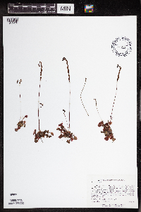 487889[1345438]Lee, Michael MDL30422001-07-13 United States, Minnesota, Lake, Finland State Forest. Lake County ... Along Ninemile Creek at junction of County Road 7 and the (Erie) Mining Railroad, 3/4 mile north- northeast of Cramer. In abandoned area on south side of large gravel pit just west of railroad tunnel ... T58N R6W SW1/4 of SE1/4 of NW1/4 Sec.3. 058N 06W 3, 47.538429 -91.082123 |
MIN:Plants | 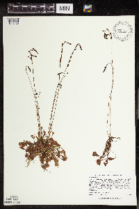 476970[1345450]Lee, Michael MDL22291998-07-08 United States, Minnesota, Carver, Carver County ... Marsh Lake Hunting Club 2-1/2 miles south of Victoria ... T116N R24W SE1/4 of SE1/4 Sec. 26;;116N;24W;26, 44.82698 -93.67245 |
MIN:Plants | 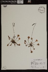 435525[1299691]Myhre, K. 6850A1997-07-08 United States, Minnesota, Carlton, Carlton Co.; Cole Lake. Located 2 miles southwest of the town of Wright. Plants occur along the northwest bays of lake; T 48N R 21W SE1/4 of NE1/4 of sec 7. 048N 21W 7, 46.658395 -93.053682 |
MIN:Plants | 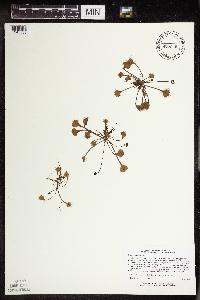 435078[1345535]Lee, Michael MDL17851997-07-01 United States, Minnesota, Stearns, Stearns Co.; Six miles south of St. Augusta; T122N R28W SE1/4 of SE1/4 Sec. 12, SW1/4 of SE1/4 Sec. 12;;122N;28W;12, 45.391357 -94.148594 |
MIN:Plants | 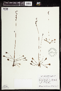 478892[1345452]Smith, Welby 158331989-07-20 United States, Minnesota, Mille Lacs, Mille Lacs Kathio State Park. Mille Lacs County...Mille Lacs Kathio State Park, about 5 miles northwest of Onamia...NE1/4 SE1/4 sec. 10, T 42N R27W. 042N 27W 10, 46.1336098 -93.7272186 |
MIN:Plants | 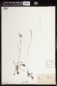 122041[1345562]Sandberg, John 6901891-07-29 United States, Minnesota, Chisago, Chisago City;;N;;, 45.373576 -92.889938 |
MIN:Plants | 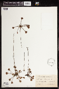 122042[1345499]Ballard, C. B4821891-07-00 United States, Minnesota, Scott, Priors Lake;;N;;, 44.71161 -93.42224 |
MIN:Plants | 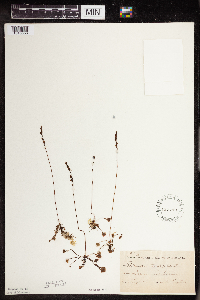 122043[1345558]Taylor, B. T11021891-08-00 United States, Minnesota, Pope, Glenwood;;N;;, 45.65 -95.365833 |
MIN:Plants |  122044[1345531]Sheldon, Edmund S3531891-06-00 United States, Minnesota, Blue Earth, S of Lake Madison;;N;;, 44.204444 -93.815556 |
MIN:Plants |  122045[1345498]Ballard, C. B17721893-07-00 United States, Minnesota, Cass, Lake Kilpatrick;;135N;29W;, 46.500163 -94.32908 |
MIN:Plants |  122046[1345532]Arthur, J.; et al. B1361886-07-20 United States, Minnesota, Saint Louis, Vermilion Lake;;;;, 47.89167 -92.36667 |
MIN:Plants |  122047[1345507]Sandberg, John s.n.1889-07-00 United States, Minnesota, Hennepin, [no further data];;;;, 45 -93.47 |
MIN:Plants | 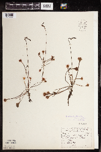 122048[1345503]Sandberg, John s.n.1891-08-00 United States, Minnesota, Chisago, [no further data];;;;, 45.506011 -92.825745 |
MIN:Plants | 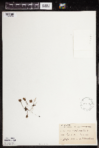 122049[1345579]Sheldon, Edmund S30541892-07-00 United States, Minnesota, Mille Lacs, Princeton;;036N;26W;, 45.602777 -93.573848 |
MIN:Plants | 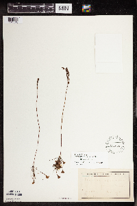 122050[1345518]Taylor, B. T11021891-08-00 United States, Minnesota, Pope, Glenwood;;N;;, 45.65 -95.365833 |
MIN:Plants | 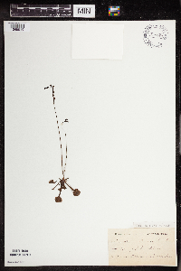 122051[1345519]Kassube, J. s.n.1878-06-00 United States, Minnesota, Hennepin, Rocky Lake;;N;;, 44.979965 -93.263836 |
MIN:Plants | 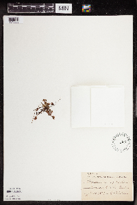 122052[1345500]Sheldon, Edmund S22661892-06-00 United States, Minnesota, Crow Wing, Garrison;;N;;, 46.294404 -93.826922 |
MIN:Plants | 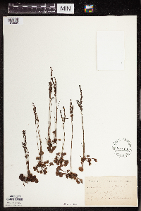 122053[1345520]Herrick, C. s.n.1878-07-00 United States, Minnesota, Hennepin, Minneapolis (Rocky Lake);;N;;, 44.979965 -93.263836 |
MIN:Plants | 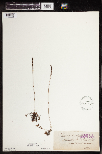 122054[1345563]Roberts, Thomas s.n.1879-09-01 United States, Minnesota, Saint Louis, Minnesota Point.;Minnesota Point;049N;13W;18, 46.749919 -92.069941 |
MIN:Plants | 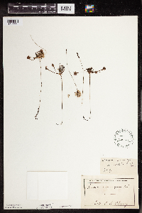 122055[1345561]Cheney, L. s.n.1891-08-08 United States, Minnesota, Saint Louis, Burntside Lake.;Superior National Forest;063N;13W;00, 47.93205 -91.98786 |
MIN:Plants | 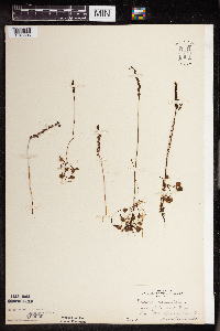 122056[1345505]MacMillan, C.; et al. 27211894-08-01 United States, Minnesota, Lake of the Woods, Garden Island;Northwest Angle;166N;33W;00, 49.193258 -94.893832 |
MIN:Plants | 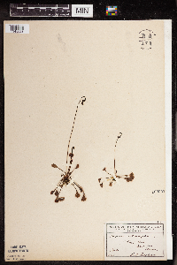 122057[1345593]Ballard, C. 37-11900-07-00 United States, Minnesota, Scott, Prior's Lake;;115N;22W;00, 44.760853 -93.459533 |
MIN:Plants | 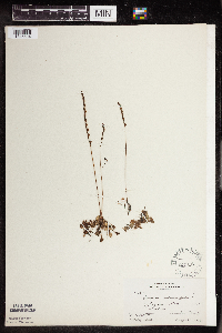 122058[1345604]Butters, F.; et al. 33841916-08-18 United States, Minnesota, Anoka, Sphagnans place;;;;, 45.198637 -93.238648 |
MIN:Plants | 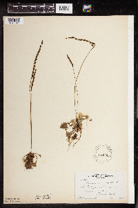 122059[1345541]Rosendahl, C. 37291918-08-23 United States, Minnesota, Clearwater, Floating Bog Bay, Itasca Park.;Itasca State Park;143N;36W;, 47.19557 -95.233216 |
MIN:Plants | 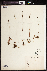 122060[1345590]Bergman, H. 30281914-08-11 United States, Minnesota, Beltrami, Bemidji;;N;;, 47.468056 -94.881389 |
MIN:Plants | 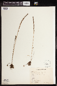 122061[1345484]Bergman, H. 31491914-09-23 United States, Minnesota, Hubbard, Benedict, Quadrat 20 B;;143N;32W;35, 47.157287 -94.695698 |
MIN:Plants | 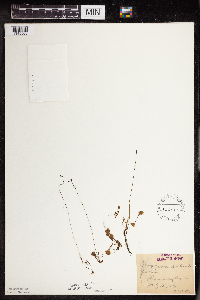 122062[1345560]Oestlund, O. s.n.1886-07-13 United States, Minnesota, Ramsey, Ramsey Co.;;;;, 45.0365 -93.09382 |
MIN:Plants | 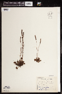 122063[1345511]Aiton, G. s.n.1889-08-00 United States, Minnesota, Hennepin, [no further data];;;;, 45 -93.47 |
MIN:Plants | 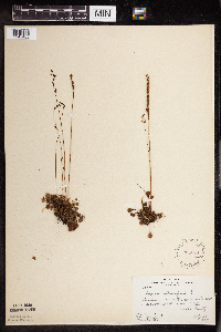 225644[1345483]Rosendahl, C.; Butters, F. 53271927-07-30 United States, Minnesota, Anoka, Near E end of peat meadow, S of Ham Lake;;032N;23W;, 45.254503 -93.203833 |
MIN:Plants | 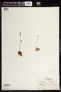 225645[1345472]Butters, F. s.n.1927-09-03 United States, Minnesota, Cook, Beach at Clarks Bay, Pigeon Point. Cook Co.;Grand Portage Indian Reservation / North Shore;064N;07E;, 47.994009 -89.575112 |
MIN:Plants | 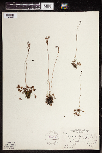 225653[1345598]Rosendahl, C.; Butters, F. 53271927-07-30 United States, Minnesota, Anoka, Near E end of peat meadow, S of Ham Lake;;032N;23W;, 45.254503 -93.203833 |
MIN:Plants | 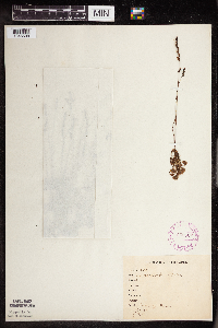 265567[1345508]Stevenson, J. 2281912-07-26 United States, Minnesota, Beltrami, Bemidji;;N;;, 47.468056 -94.881389 |
MIN:Plants |  276137[1345479]Grant, Martin 31031929-08-17 United States, Minnesota, Hubbard, Itasca park, SE of Mary Lake; NW1/4 NE1/4 Sec. 30 T143N R35W;Itasca State Park;143N;35W;30, 47.174244 -95.160702 |
MIN:Plants |  276878[1345603]Huff, N. s.n.1926-08-07 United States, Minnesota, Koochiching, Koochiching Co.;;;;, 48.245268 -93.783366 |
MIN:Plants |  277071[1345480]Rosendahl, C. 43991923-07-12 United States, Minnesota, Hubbard, E of Twin Lakes, Itasca Park;Itasca State Park;143N;35W;, 47.195787 -95.107789 |
MIN:Plants |  277797[1345521]Roberts, Thomas s.n.1884-06-00 United States, Minnesota, Hennepin, Minneapolis;;N;;, 44.979965 -93.263836 |
MIN:Plants | 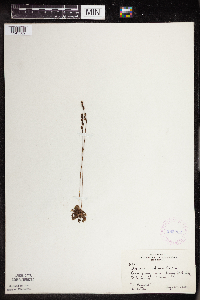 282222[1345582]Rosendahl, C.; Butters, F. 63551930-08-29 United States, Minnesota, Cook, Cook Co.; Near Hungry Jack Lake;Superior National Forest;064N;01W;, 48.019271 -90.447457 |
MIN:Plants | 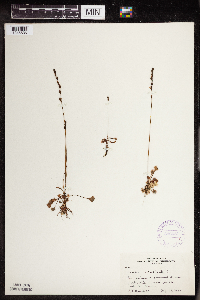 306581[1345536]Rosendahl, C. 63041930-08-26 United States, Minnesota, Cook, Cook Co.;;N;;, 47.726653 -90.386005 |
MIN:Plants | 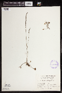 332577[1345478]Grant, Martin 66021935-08-12 United States, Minnesota, Hubbard, Itasca Park, SE of Mary Lake; NW1/4 NE1/4 Sec. 30 T143N R35W;Itasca State Park;143N;35W;30, 47.174244 -95.160702 |
MIN:Plants | 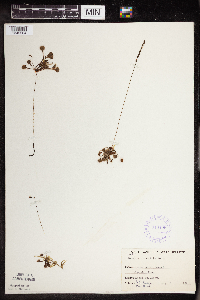 348406[1345504]Buell, Murray; Buell, Helen 6941933-08-03 United States, Minnesota, Anoka, Decodon Pond;Cedar Creek National History Area;034N;23W;27, 45.406779 -93.193727 |
MIN:Plants | 350393[]Nielsen, E. 821930-07-25 United States, Minnesota, Cass, Norway Beach, NE of Cass Lake;Chippewa National Forest / Leech Lake Indian Reservation;145N;30W;, 47.36791 -94.480376 |
MIN:Plants |  350401[1345477]Nielsen, E. 19531933-05-29 United States, Minnesota, Clearwater, Garrison Point, Itasca State Park;Itasca State Park;143N;36W;, 47.19557 -95.233216 |
MIN:Plants |  351344[1345476]Nielsen, E. 24791934-05-31 United States, Minnesota, Clearwater, Garrison Point, Itasca State Park;Itasca State Park;143N;36W;, 47.19557 -95.233216 |
MIN:Plants |  352689[1345583]Benner, F.; Benner, J. 6751929-08-23 United States, Minnesota, Cook, Just E Grand Portage;Grand Portage Indian Reservation / North Shore;063N;06E;, 47.958468 -89.703576 |
MIN:Plants |  354555[1345526]Lakela, Olga 26781938-08-05 United States, Minnesota, Saint Louis, Ca. 16 mi N from Duluth on hwy no. 4;;N;;, 47.01245 -92.14371 |
MIN:Plants | 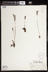 360232[1345510]Lakela, Olga 4218a1940-09-08 United States, Minnesota, Saint Louis, Below the dam of Little Cloquet River on Barr's Road;;N;;, 47.06965 -92.02835 |
MIN:Plants | 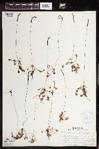 360550[1345589]Lakela, Olga 39731940-08-07 United States, Minnesota, Saint Louis, Lake ca. 6 im SE of Gilbert, hwy 20;;N;;, 47.45514 -92.39004 |
MIN:Plants | 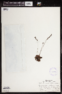 360572[1345588]Lakela, Olga 42181940-09-08 United States, Minnesota, Saint Louis, In the Little Cloquet River, on Barr's Rd.;;N;;, 47.06848 -92.02784 |
MIN:Plants | 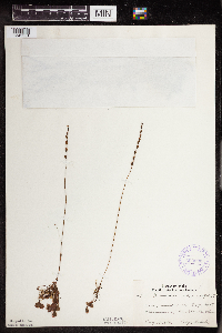 360693[1345551]Lakela, Olga 41141940-08-18 United States, Minnesota, Carlton, E of Barnum.;;N;;, 46.503001 -92.688531 |
MIN:Plants |  361131[1345530]Lakela, Olga 38691940-08-01 United States, Minnesota, Saint Louis, 9 mi S of Orr on hwy 53;Kabetogama State Forest;N;;, 47.923265 -92.831002 |
MIN:Plants |  364089[1345552]Taylor, B. s.n.1891-08-00 United States, Minnesota, Pope, Glenwood;;N;;, 45.65 -95.365833 |
MIN:Plants |  364103[1345473]Warnock, C. s.n.1934-08-21 United States, Minnesota, Clearwater, Itasca State Park, adjacent to bog;Itasca State Park;143N;36W;, 47.19557 -95.233216 |
MIN:Plants |  371662[1345585]Lakela, Olga 47291941-08-09 United States, Minnesota, Lake, At the Springs on Tofte-Isabella Road;;N;;, 47.598613 -91.092572 |
MIN:Plants | 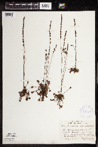 372558[1345594]Lakela, Olga 47411941-08-13 United States, Minnesota, Carlton, Ditch at Holyoke, near the RR Station;;N;;, 46.467443 -92.388528 |
MIN:Plants | 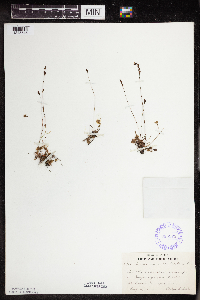 385973[1345545]Lakela, Olga 58051944-08-04 United States, Minnesota, Saint Louis, Esquagama Lake;;N;;, 47.467001 -92.356147 |
MIN:Plants | 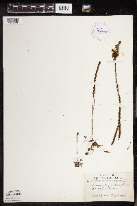 391739[1345509]Lakela, Olga 62251945-09-15 United States, Minnesota, Saint Louis, Along St. Louis River at New Duluth;;N;;, 46.659942 -92.226304 |
MIN:Plants | 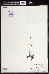 392915[1345502]Lakela, Olga 71541947-08-12 United States, Minnesota, Saint Louis, On road to Skibo Observation Tower;;N;;, 47.485479 -91.994337 |
MIN:Plants | 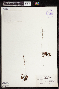 393014[1345497]Lakela, Olga 73511947-09-05 United States, Minnesota, Saint Louis, Abandoned road, S of Ely Lake and Eveleth;;N;;, 47.437668 -92.486018 |
MIN:Plants | 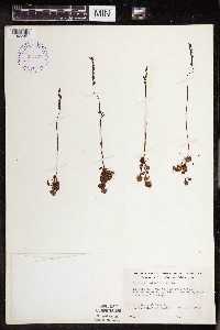 393127[1345501]Ownbey, Gerald; et al. 11141948-08-16 United States, Minnesota, Cook, Cook Co.; About midcenter of Long Island, Susie Island near Grand Portage;North Shore / Susie Islands, The Nature Conservancy;063N;07E;, 47.973776 -89.578978 |
MIN:Plants | 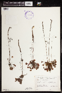 393220[1345546]Ownbey, Gerald; et al. 10011948-08-11 United States, Minnesota, Cook, Cook Co.; 1 mi. NE of Temperance River bridge, Highway 61.;North Shore / Superior National Forest;059N;04W;, 47.599359 -90.844189 |
MIN:Plants | 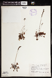 393234[1345490]Ownbey, Gerald; et al. 10681948-08-14 United States, Minnesota, Cook, Cook County...NW side of Belle Rose Island, Susie Isands near Grand Portage;North Shore / Susie Islands, The Nature Conservancy;063N;07E;, 47.973776 -89.578978 |
MIN:Plants | 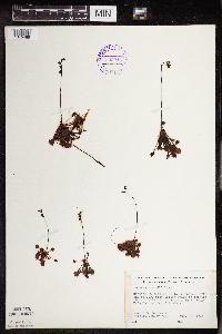 393246[1345489]Ownbey, Gerald; et al. 10171948-08-12 United States, Minnesota, Cook, North Shore / Susie Islands, The Nature Conservancy. Cook County...North end of Porcupine Island which is located about 1 mile NE of Susie Island, Susie Islands near Grand Portage. 064N 07E, 47.994009 -89.575112 |
MIN:Plants | 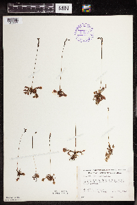 393257[1345529]Ownbey, Gerald; et al. 11321948-08-18 United States, Minnesota, Cook, Cook County...Center of Susie Island, Susie Islands, near Grand Portage.;North Shore / Susie Islands, The Nature Conservancy;063N;07E;, 47.973776 -89.578978 |
MIN:Plants | 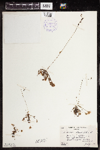 394710[1345559]Butters, F.; Abbe, E. 8301944-07-30 United States, Minnesota, Cook, Near trail between Birch and Poplar Lakes. T64N, R02W.;Superior National Forest;064N;02W;, 48.019752 -90.574838 |
MIN:Plants | 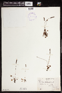 394711[1345553]Abbe, E.; Abbe, L. 5041937-08-18 United States, Minnesota, Cook, Middle of Long Island. T63N 7E.;North Shore / Susie Islands, The Nature Conservancy;063N;07E;, 47.973776 -89.578978 |
MIN:Plants | 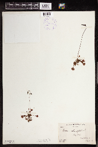 394712[1345554]Butters, F.; Abbe, E.; Abbe, L. 4641937-07-14 United States, Minnesota, Cook, Long Island;North Shore / Susie Islands, The Nature Conservancy;063N;07E;, 47.973776 -89.578978 |
MIN:Plants | 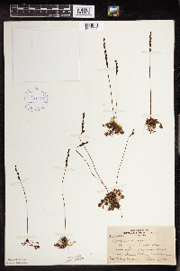 394713[1345555]Nielsen, E. 16491932-09-09 United States, Minnesota, Cook, Cook Co.; Near the outer shore and upward end of Susie Island, near Grand Portage.;North Shore / Susie Islands, The Nature Conservancy;064N;07E;, 47.994009 -89.575112 |
MIN:Plants | 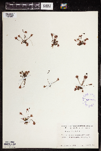 403149[1345486]Schuster, R. A74141948-06-26 United States, Minnesota, Cook, Cook Co.; Ditch 1 mi N of Temperance River, on hwy 65 [prob hwy 61];North Shore / Superior National Forest;059N;04W;, 47.599359 -90.844189 |
MIN:Plants | 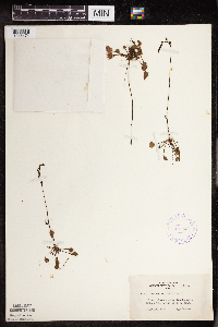 407521[1345474]Lakela, Olga 89841949-07-14 United States, Minnesota, Saint Louis, Shore, Fenske Lake, Echo Trail N of Ely;Superior National Forest;N;;, 47.994422 -91.904667 |
MIN:Plants | 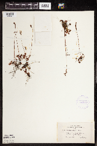 407649[1345482]Lakela, Olga 91661949-07-24 United States, Minnesota, Saint Louis, On St. Louis River at New Duluth;;N;;, 46.659942 -92.226304 |
MIN:Plants | 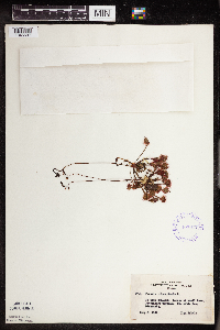 407827[1345597]Lakela, Olga 87101949-07-03 United States, Minnesota, Saint Louis, Border of small lake; Fredenburg Twp.;;N;;, 46.97276 -92.20963 |
MIN:Plants | 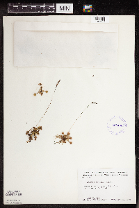 409196[1345595]Moore, John; Moore, Marjorie 112571939-07-28 United States, Minnesota, Lake of the Woods, 2 1/4 mi S of Angle Inlet;Northwest Angle;N;;, 49.312716 -95.062738 |
MIN:Plants | 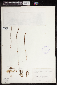 412764[1345596]Moore, John; Moore, Marjorie 117901939-08-16 United States, Minnesota, Koochiching, Koochiching Co.; 1/2 mi E of Tilson Bay, Rainy Lake 1/2 mi E of Tilson Bay, Rainy Lake. 071N 22W, 48.609164 -93.157413 |
MIN:Plants |  419192[1345488]Briggs, John De Q.; Briggs, Marjorie 841945-08-07 United States, Minnesota, Cook, Kelso River; T63N R4W;Boundary Waters Canoe Area Wilderness / Superior National Forest;063N;04W;, 47.932001 -90.831315 |
MIN:Plants |  419193[1345487]Schuster, R.; et al. 60141947-07-15 United States, Minnesota, Cook, Cook Co.; SW end of Gunflint Lake;Boundary Waters Canoe Area Wilderness / Superior National Forest;065N;03W;00, 48.081129 -90.704859 |
MIN:Plants |  419258[1345485]Schuster, R.; et al. 60291947-07-15 United States, Minnesota, Cook, Cook Co.; North Shore, 1/2 mi S of Temperance R.;North Shore / Superior National Forest;059N;04W;, 47.599359 -90.844189 |
MIN:Plants |  428332[1345572]Smith, Welby 138891987-08-19 United States, Minnesota, Lake, Lake County...on the N side of Makwa Lake in the BWCAW,Superior National Forest; SE1/4 SW1/4 sec.23, T64N R6W;Boundary Waters Canoe Area Wilderness / Superior National Forest;064N;06W;23, 48.011561 -91.056073 |
MIN:Plants |  429841[1311735]Smith, Welby 194331991-07-10 United States, Minnesota, Koochiching, Koochiching State Forest. Koochiching Co.; On the north side of Moose Lake, about 6 miles east of Little Fork; T68N R24W SE1/4 of SE1/4 of Sec 9 Koochiching Co.; On the north side of Moose Lake, about 6 miles east of Little Fork; T 68N R 24W SE1/4 of SE1/4 of Sec 9. 068N 24W 9, 48.3922234 -93.4236145 |
MIN:Plants |  439599[1345570]Smith, Welby 162911989-08-30 United States, Minnesota, Kanabec, Kanabek [sic] Co.; about 17 mi N-NE of Mora; NW1/4 NW1/4 sec.14, T42N R22W;;042N;22W;14, 46.1286125 -93.0930557 |
MIN:Plants |  440045[1345575]Smith, Welby 143381988-06-25 United States, Minnesota, Aitkin, Long Lake Conservation Center, about 7.5 mi W-NW of McGregor; N side of Long Lake. SW1/4 NW1/4 of section;<No data>;048N;25W;13, 46.6477778 -93.46 |
MIN:Plants |  440984[1345573]Smith, Welby 148501988-08-12 United States, Minnesota, Washington, Belwin Outdoor Education Laboratory. Washington Co. Belwin Outdoor Education Laboratory, about 1/2 mi W of St. Mary's Point; (Trails End Marsh); NE1/4 NE1/4 sec.15, T28N R20W. 028N 20W 15, 44.9213889 -92.7833333 |
MIN:Plants | 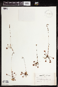 442536[1345491]Lakela, Olga 134581951-07-19 United States, Minnesota, Saint Louis, Ash River Road ca. 5 mi from #53;Kabetogama State Forest;N;;, 48.38613 -92.87395 |
MIN:Plants | 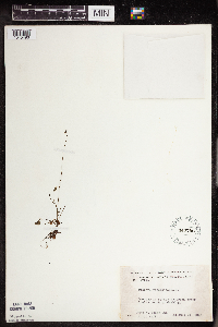 444708[1345493]Moore, John; Huff, N. 179291945-07-24 United States, Minnesota, Morrison, 1 mi S of Cushing;;N;;, 46.12521 -94.576956 |
MIN:Plants | 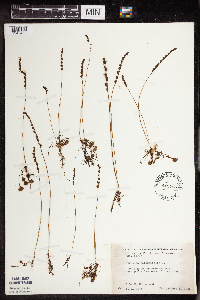 445795[1345492]Moore, John; Huff, N. 183271945-10-05 United States, Minnesota, Pine, 3 mi W of Pine City;;N;;, 45.82605 -93.030877 |
MIN:Plants | 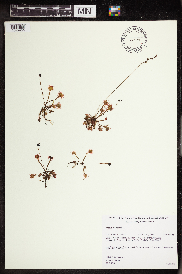 447091[1345455]Gerdes, Lynden 27481998-06-18 United States, Minnesota, Cook, Superior National Forest. T65N R02W S27SESW. Cook Co.; Superior National Forest. ENE from the NE corner of Mayhew Lake, approximately 0.4 miles NE T65N R02W S27SESW. Cook Co.; Superior National Forest. ENE from the NE corner of Mayhew Lake, approximately 0.4 miles NE of the Gunflint Trail (Cty. 12) on FR 317.. 065N 02W 27, 48.084674 -90.565752 |
MIN:Plants | 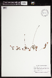 447118[1345496]Smith, Welby 191371991-07-08 United States, Minnesota, Koochiching, Koochiching County...About 6 miles south of Birchdale...T 159N R 27W NE1/4 of SE1/4 of Sec 34;;159N;27W;34, 48.5475006 -94.082222 |
MIN:Plants | 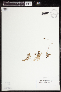 456922[1345568]Smith, Welby 179861990-09-10 United States, Minnesota, Marshall, Thief Lake Wildlife Management Area. Marshall Co.; Thief Lake State Wildlife Management Area, about 17.5 miles north of Grygla; Marshall Co.; Thief Lake State Wildlife Management Area, about 17.5 miles north of Grygla; T 158N R 39W NW1/4 of NW1/4 of Sec 31. 158N 39W 31, 48.4633331 -95.7277756 |
MIN:Plants | 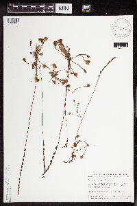 458934[1345456]Smith, Welby 146161988-07-25 United States, Minnesota, Pine, Pine Co.; west side of Pickerel Lake, about 5 miles S-SW of Holyoke. SE1/4 SW1/4 sec. 1, T 45N R 17W;Nemadji State Forest;045N;17W;1, 46.410416 -92.435581 |
Google Map
Google Maps is a web mapping service provided by Google that features a map that users can pan (by dragging the mouse) and zoom (by using the mouse wheel). Collection points are displayed as colored markers that when clicked on, displays the full information for that collection. When multiple species are queried (separated by semi-colons), different colored markers denote each individual species.