University of Minnesota
http://www.umn.edu/
612-625-5000
http://www.umn.edu/
612-625-5000
Minnesota Biodiversity Atlas
Bell Museum
Dataset: MIN-Plants
Taxa: Fumariaceae
Search Criteria: excluding cultivated/captive occurrences
Bell Museum plants | |
 MIN:Plants | 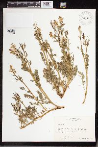 960432[1318935] 23591963-04-20 United States, New Mexico, Grant, Approximately one mile north of Silver City, New Mexico, Growing adjacent to U.S. Highway 260 |
MIN:Plants | Corydalis sempervirens (L.) Persoon 491500[]Wheeler, Gerald 169091997-07-27 United States, Minnesota, Stearns, Stearns County ... Ca. 3 mi. W of Cold Spring on Rte. 23; 0.5 mi. S on Frostview Road, NE of road ... NE1/4 SW1/4 SW1/4 SW1/4 Sec. 20 T123N R30W (Wakefield 20). 123N 30W 20, 45.4492238 -94.4760102 |
MIN:Plants | Corydalis sempervirens (L.) Persoon 499628[]Wheeler, Gerald 167261997-07-23 United States, Minnesota, Stearns, S side of Waite Park, near St. Cloud. SE1/4 NW1/4 NW1/4 NW1/4 Sec.;Quarry Park Nature Preserve & Scientific Natural Area;124N;28W;29, 45.5227251 -94.2296146 |
MIN:Plants | Corydalis sempervirens (L.) Persoon 473277[]Lee, Michael MDL18241997-07-15 United States, Minnesota, Stearns, On the south side of the city of Waite Park. SE1/4 of NW1/4 of NW1/4 Sec.;Quarry Park Nature Preserve & Scientific Natural Area;124N;28W;29, 45.5227251 -94.2296146 |
MIN:Plants | Corydalis sempervirens (L.) Persoon 430323[]Lee, Michael MDL19741997-09-25 United States, Minnesota, Stearns, Stearns Co.; In the Sauk River Valley 1-1/2 miles west of Cold Spring; T123N R30W NW1/4 of NW1/4 of NW1/4 Sec. 21;;123N;30W;21, 45.4494101 -94.4553971 |
MIN:Plants | Corydalis sempervirens (L.) Persoon 480772[]Gerdes, Lynden; et al. 25471998-05-29 United States, Minnesota, Cook, T65N R01W S33NESW. Cook County ... Superior National Forest, Caribou Rock Hiking Trail, vicinity of Duncan Lake.;Superior National Forest;065N;01W;33, 48.0699985 -90.4595082 |
MIN:Plants | Corydalis sempervirens (L.) Persoon 491522[]Wheeler, Gerald 168381997-07-25 United States, Minnesota, Benton, Benton County ... Ca. 0.7 mi. SSW of Watab on Rte. 55 ... W1/2 NW1/4 SE1/4 Sec. 27 T37N R31W (Watab 27);;037N;31W;27, 45.6684162 -94.1848462 |
MIN:Plants | Corydalis sempervirens (L.) Persoon 904561[]Zager, S. 256981995-06-27 United States, Minnesota, Kanabec, Hay Snake Wildlife Management Area. Kanabec County...Hay-Snake State Wildlife Management Area, about one mile east of Woodland (town)...T42N R23W SW1/4 of SW1/4 of Sec 16. 042N 23W 16, 46.1180556 -93.2613889 |
MIN:Plants | Corydalis sempervirens (L.) Persoon 116376[]Butters, F. s.n.1918-09-00 United States, Minnesota, Saint Louis, Island, Burntside Lake, NE St. Louis Co.;Superior National Forest;063N;13W;00, 47.9357 -91.982299 |
MIN:Plants | Corydalis sempervirens (L.) Persoon 116377[]Roberts, Thomas s.n.1879-08-25 United States, Minnesota, Cook, Carltons Peak, at summit. Cook Co.;North Shore / Superior National Forest;059N;04W;, 47.584341 -90.859987 |
MIN:Plants | Corydalis sempervirens (L.) Persoon 116378[]Sheldon, Edmund S22611892-06-00 United States, Minnesota, Crow Wing, [illegible];;N;;, 46.482372 -94.070879 |
MIN:Plants | Corydalis sempervirens (L.) Persoon 116379[]Sheldon, Edmund S49401893-06-00 United States, Minnesota, Lake, Knife River;North Shore;052N;11W;31, 46.94743 -91.78709 |
MIN:Plants | Corydalis sempervirens (L.) Persoon 116380[]Sheldon, Edmund s.n.1892-06-00 United States, Minnesota, Aitkin, Farm Island Lake;;N;;, 46.422051 -93.772021 |
MIN:Plants | Corydalis sempervirens (L.) Persoon 116382[]Arthur, J.; et al. B1141886-07-17 United States, Minnesota, Saint Louis, Vermilion Lake;;;;, 47.89167 -92.36667 |
MIN:Plants | Corydalis sempervirens (L.) Persoon 116383[]Roberts, Thomas s.n.1878-07-00 United States, Minnesota, Put in Bay [prob. along the North Shore where Thomas collected often];North Shore;;;, 47.573376 -90.827728 |
MIN:Plants | Corydalis sempervirens (L.) Persoon 116384[]Sandberg, John s.n.1885-06-00 United States, Minnesota, Saint Louis, Tower;;N;;, 47.810087 -92.280441 |
MIN:Plants | Corydalis sempervirens (L.) Persoon 116385[]Roberts, Thomas s.n.1878-06-00 United States, Minnesota, Saint Louis, Duluth;;N;;, 46.774809 -92.124432 |
MIN:Plants | Corydalis sempervirens (L.) Persoon 116386[]Arthur, J.; et al. B3331886-07-23 United States, Minnesota, Saint Louis, St. Louis River. [prob St. Louis Co. as the area where these collectors mostly worked];;;;, 46.721228 -92.190928 |
MIN:Plants | Corydalis sempervirens (L.) Persoon 116387[]Sheldon, Edmund S32331892-07-00 United States, Minnesota, Mille Lacs, Milaca;;037N;27W;, 45.755799 -93.65149 |
MIN:Plants | Corydalis sempervirens (L.) Persoon 116388[]Sheldon, Edmund S49691893-06-00 United States, Minnesota, Lake, Two Harbors;North Shore;052N;11W;, 47.02278 -91.67056 |
MIN:Plants | Corydalis sempervirens (L.) Persoon 116389[]Anderson, A. A4451893-06-00 United States, Minnesota, Cass, Gull Lake;;N;;, 46.442121 -94.355797 |
MIN:Plants | Corydalis sempervirens (L.) Persoon 116390[]Herrick, C. s.n.1884-06-26 United States, Minnesota, Carlton, St. Louis River.;Jay Cooke State Park;048N;15W;, 46.643301 -92.352377 |
MIN:Plants | Corydalis sempervirens (L.) Persoon 116391[]Rosendahl, C. 26281912-08-26 United States, Minnesota, Cook, Kimball Creek, N shore.;North Shore / Superior National Forest;061N;02E;, 47.785685 -90.18274 |
MIN:Plants | Corydalis sempervirens (L.) Persoon 116393[]Wood, F. s.n.1891-06-23 United States, Minnesota, Cook, Grand Marais;North Shore;061N;01E;, 47.750447 -90.334273 |
MIN:Plants | Corydalis sempervirens (L.) Persoon 227582[]Stork, H. 11551925-00-00 United States, Minnesota, Itasca, Bowstring;Chippewa National Forest;;;, 47.54306 -93.79639 |
MIN:Plants | Corydalis sempervirens (L.) Persoon 227601[]Rosendahl, C.; Butters, F. 46601924-07-07 United States, Minnesota, Cook, Grand Marais;North Shore;061N;01E;, 47.750447 -90.334273 |
MIN:Plants | Corydalis sempervirens (L.) Persoon 227602[]Rosendahl, C.; Butters, F. 46601924-07-07 United States, Minnesota, Cook, Grand Marais;North Shore;061N;01E;, 47.750447 -90.334273 |
MIN:Plants | Corydalis sempervirens (L.) Persoon 265528[]Stevenson, J. 161912-06-18 United States, Minnesota, Beltrami, Bemidji;;N;;, 47.473563 -94.880277 |
MIN:Plants | Corydalis sempervirens (L.) Persoon 276012[]Grant, Martin 28451929-07-19 United States, Minnesota, Clearwater, Nursery, Itasca Park.;Itasca State Park;143N;36W;2, 47.2319733 -95.201528 |
MIN:Plants | Corydalis sempervirens (L.) Persoon 276981[]Huff, N. 681914-07-04 United States, Minnesota, Lake, North Kawashiwi River.;Boundary Waters Canoe Area Wilderness / Superior National Forest;N;;, 47.906853 -91.665919 |
MIN:Plants | Corydalis sempervirens (L.) Persoon 277772[]Roberts, Thomas s.n.1877-07-06 United States, Minnesota, Carlton, N.P. Junction ["Northern Pacific Junction" = historic name for Carlton];;048N;17W;00, 46.663439 -92.430053 |
MIN:Plants | Corydalis sempervirens (L.) Persoon 281344[]Roberts, Thomas s.n.1884-07-29 United States, Minnesota, Chisago, Taylors Falls;;034N;19W;, 45.401906 -92.652429 |
MIN:Plants | Corydalis sempervirens (L.) Persoon 282685[]Swanson, Gustav s.n.1932-08-14 United States, Minnesota, Lake of the Woods, Northwest Angle;Northwest Angle;168N;34W;, 49.269284 -95.055969 |
MIN:Plants | Corydalis sempervirens (L.) Persoon 283324[]Butters, F.; Buell, Murray 3491932-07-08 United States, Minnesota, Cook, Susie Is, Lake Superior;North Shore / Susie Islands, The Nature Conservancy;063N;07E;, 47.973776 -89.578978 |
MIN:Plants | Corydalis sempervirens (L.) Persoon 283969[]Butters, F.; Buell, Murray 3391932-07-07 United States, Minnesota, Cook, Cook Co.; Cliff 5 mi E of McFarland Lake, along road;Superior National Forest;064N;03E;, 48.023145 -90.018934 |
MIN:Plants | Corydalis sempervirens (L.) Persoon 289455[]Fryklund, P. s.n.1924-05-08 United States, Minnesota, Lake of the Woods, Bear Point;;N;;, 48.887883 -94.887054 |
MIN:Plants | Corydalis sempervirens (L.) Persoon 304440[]Lakela, Olga 13001935-09-15 United States, Minnesota, Saint Louis, Above Congdon Creek near Vermilion Road, Duluth;;N;;, 46.822692 -92.067912 |
MIN:Plants | Corydalis sempervirens (L.) Persoon 306865[]Cottrell, R. s.n.1935-07-04 United States, Minnesota, Chisago, Taylors Falls;;034N;19W;, 45.401906 -92.652429 |
MIN:Plants | Corydalis sempervirens (L.) Persoon 345545[]Lakela, Olga 20401937-07-09 United States, Minnesota, Saint Louis, Duluth; Sec. 18;;N;;18, 46.774809 -92.124432 |
MIN:Plants | 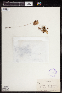 Corydalis sempervirens (L.) Persoon 350395[1345592]Nielsen, E. 11951931-06-14 United States, Minnesota, Carlton, One mi. out of Carlton on road to Cloquet.;;N;;, 46.680641 -92.425711 |
MIN:Plants | Corydalis sempervirens (L.) Persoon 352309[]Benner, F.; Benner, J. 6111929-08-22 United States, Minnesota, Cook, 5 mi. N of Hovland.;Grand Portage State Forest;063N;04E;, 47.911151 -89.972041 |
MIN:Plants | Corydalis sempervirens (L.) Persoon 353290[]Lakela, Olga 24611938-06-11 United States, Minnesota, Saint Louis, Above Haines Road on Skyline Parkway, Duluth.;;N;;, 46.761112 -92.165251 |
MIN:Plants | Corydalis sempervirens (L.) Persoon 353573[]Lakela, Olga 24851938-06-25 United States, Minnesota, Saint Louis, Duluth; Sec. 18;;N;;18, 46.774809 -92.124432 |
MIN:Plants | Corydalis sempervirens (L.) Persoon 353723[]Moyle, J. 14601934-07-12 United States, Minnesota, Clearwater, S of Squaw Lake. Roadside.;Itasca State Park;143N;36W;, 47.195125 -95.225997 |
MIN:Plants | Corydalis sempervirens (L.) Persoon 356104[]Lakela, Olga 31611939-07-15 United States, Minnesota, Lake, Top of the Great Palisade on Lake Superior, 65 mi N of Duluth;North Shore / Palisade Head;056N;07W;22, 47.32413 -91.2136413 |
MIN:Plants | Corydalis sempervirens (L.) Persoon 360304[]Lakela, Olga 40211940-08-13 United States, Minnesota, Carlton, Roadside hwy 23, ca. 4 mi NW of Holyoke;;N;;, 46.512214 -92.401093 |
MIN:Plants | Corydalis sempervirens (L.) Persoon 360490[]Lakela, Olga 35671940-06-16 United States, Minnesota, Saint Louis, Above Brecks Road near Fond du Lac Junction, Duluth.;;N;;, 46.678158 -92.234109 |
MIN:Plants | Corydalis sempervirens (L.) Persoon 362275[]Lakela, Olga 38521940-08-01 United States, Minnesota, Saint Louis, Ca. 1 mi S of Idington, hwy 53;;N;;, 47.718781 -92.651845 |
MIN:Plants | Corydalis sempervirens (L.) Persoon 362399[]Lakela, Olga 36291940-07-04 United States, Minnesota, Cook, Windigo Point, Sea Gull Lake;Boundary Waters Canoe Area Wilderness / Superior National Forest;065N;05W;, 48.149256 -90.887916 |
MIN:Plants | Corydalis sempervirens (L.) Persoon 363894[]Gilbert, H. 2761923-07-12 United States, Minnesota, Saint Louis, N of Duluth.;;N;;, 46.880044 -92.145031 |
MIN:Plants | Corydalis sempervirens (L.) Persoon 364688[]Moyle, J. 34931940-06-23 United States, Minnesota, Lake, County: Lake. Two Harbors.;North Shore;052N;11W;00, 47.022711 -91.670732 |
MIN:Plants | Corydalis sempervirens (L.) Persoon 367079[]Carlander, K. s.n.1940-06-25 United States, Minnesota, Lake of the Woods, E side of Zippel Bay;Zippel Bay State Park;N;;, 48.867036 -94.861789 |
MIN:Plants | Corydalis sempervirens (L.) Persoon 368704[]Lakela, Olga 45291941-07-23 United States, Minnesota, Saint Louis, Cliffs of Vermilion Gorge, Crane Lake;Superior National Forest;N;;, 48.274072 -92.514603 |
MIN:Plants | Corydalis sempervirens (L.) Persoon 371617[]Lakela, Olga 46451941-07-29 United States, Minnesota, Lake, On Blueberry Hill, near Little Marais;;N;;, 47.418179 -91.123208 |
MIN:Plants | Corydalis sempervirens (L.) Persoon 378809[]Lakela, Olga 53871943-08-10 United States, Minnesota, Saint Louis, 6 mi S of Eveleth;;N;;, 47.375578 -92.539906 |
MIN:Plants | Corydalis sempervirens (L.) Persoon 391831[]Lakela, Olga 60511945-07-21 United States, Minnesota, Lake, On Beaver Island in Lake Superior, East Beaver Bay, Lake Co.;North Shore;055N;07W;05, 47.2835745 -91.2544516 |
MIN:Plants | Corydalis sempervirens (L.) Persoon 392861[]Lakela, Olga 65621946-08-11 United States, Minnesota, Saint Louis, above Burntside Lake, North arm.;Superior National Forest;064N;13W;00, 47.991171 -91.968081 |
MIN:Plants | Corydalis sempervirens (L.) Persoon 393120[]Ownbey, Gerald 9541948-05-30 United States, Minnesota, Cook, Cook Co.; Summit overlooking Moss Lake, Gunflint trail ca. 30 mi N of Grand Marais;Superior National Forest;065N;01W;, 48.066907 -90.479387 |
MIN:Plants | Corydalis sempervirens (L.) Persoon 393197[]Ownbey, Gerald; et al. 10581948-08-14 United States, Minnesota, Cook, Cook County...NE end of Belle Rose Island, Susie Islands near Grand Portage;North Shore / Susie Islands, The Nature Conservancy;063N;07E;, 47.973776 -89.578978 |
MIN:Plants | Corydalis sempervirens (L.) Persoon 395004[]Butters, F.; Abbe, E.; Burns, G. 6561940-07-01 United States, Minnesota, Cook, Cliff on the W side of North Fowl Lake. T65N, R03E.;Superior National Forest;065N;03E;, 48.074534 -90.030551 |
MIN:Plants | Corydalis sempervirens (L.) Persoon 395005[]Butters, F.; Burns, G. 7261940-07-05 United States, Minnesota, Cook, Top of point SW of Morrison Bay, Pigeon Point; T64N R7E;Grand Portage Indian Reservation / North Shore;064N;07E;, 47.984362 -89.57921 |
MIN:Plants | Corydalis sempervirens (L.) Persoon 395006[]Dahl, A. 1381945-06-20 United States, Minnesota, Cook, Above (NE) Moss Lake; T65N R1W Sec. 33;Boundary Waters Canoe Area Wilderness / Superior National Forest;065N;01W;33, 48.0699985 -90.4595082 |
MIN:Plants | Corydalis sempervirens (L.) Persoon 395007[]Butters, F.; Moore, John 108211939-07-02 United States, Minnesota, Cook, Bluff above outlet of South Fowl Lake;Pigeon River Cliffs, The Nature Conservancy / Superior National Forest;064N;03E;12, 48.044201 -90.0032544 |
MIN:Plants | Corydalis sempervirens (L.) Persoon 395008[]Burns, G.; Hendrickson, M. 2131938-07-22 United States, Minnesota, Cook, N of center of East Pike Lake; T65N R3E;Boundary Waters Canoe Area Wilderness / Superior National Forest;065N;03E;, 48.084701 -90.10426 |
MIN:Plants | Corydalis sempervirens (L.) Persoon 395009[]Burns, G.; Hendrickson, M. 3681938-08-01 United States, Minnesota, Cook, Cliff back of McFarland Lodge, McFarland Lake; T64N R3E;Boundary Waters Canoe Area Wilderness / Superior National Forest;064N;03E;, 48.050285 -90.065743 |
MIN:Plants | Corydalis sempervirens (L.) Persoon 395010[]Burns, G.; Hendrickson, M. 3851938-08-05 United States, Minnesota, Cook, Cook Co.; Alder Lake.;Boundary Waters Canoe Area Wilderness / Superior National Forest;064N;01E;, 48.045571 -90.293351 |
MIN:Plants | Corydalis sempervirens (L.) Persoon 395011[]Brown, Spencer 251935-00-00 United States, Minnesota, Cook, Grand Portage, T63N, R06E.;Grand Portage Indian Reservation / North Shore;063N;06E;, 47.963776 -89.684812 |
MIN:Plants | Corydalis sempervirens (L.) Persoon 395012[]Burns, G.; Hendrickson, M. 1781938-07-20 United States, Minnesota, Cook, 3/4 mi. N of the middle of West Pike Lake, T65N, R2E.;Boundary Waters Canoe Area Wilderness / Superior National Forest;065N;02E;, 48.096711 -90.201289 |
MIN:Plants | Corydalis sempervirens (L.) Persoon 395013[]Butters, F.; et al. 691938-07-09 United States, Minnesota, Cook, 1/2 mi. from E end of Mountain Lake. ;Boundary Waters Canoe Area Wilderness / Superior National Forest;065N;02E;, 48.107762 -90.1578 |
MIN:Plants | Corydalis sempervirens (L.) Persoon 395158[]Butters, F.; Abbe, E.; Abbe, L. 3641937-07-11 United States, Minnesota, Cook, S shore of Lucille Island; T63N R7E;North Shore / Susie Islands, The Nature Conservancy;063N;07E;, 47.964054 -89.577589 |
MIN:Plants | Corydalis sempervirens (L.) Persoon 395159[]Butters, F.; Abbe, E. 1401936-06-27 United States, Minnesota, Cook, Winchell Lake; T64N R2W;Boundary Waters Canoe Area Wilderness / Superior National Forest;064N;02W;, 47.992195 -90.595737 |
MIN:Plants | Corydalis sempervirens (L.) Persoon 395160[]Butters, F.; Abbe, E. 8731944-08-02 United States, Minnesota, Cook, Top of Lima Mt. T64N, R01W.;Superior National Forest;064N;01W;, 47.987167 -90.404456 |
MIN:Plants | Corydalis sempervirens (L.) Persoon 395161[]Butters, F.; Abbe, E. 1681936-06-28 United States, Minnesota, Cook, Cook Co. Top of Mt. Josephine, near Grand Portage; T63N R6E [actually T64];Grand Portage Indian Reservation / North Shore;064N;06E;34, 47.9830977 -89.66244 |
MIN:Plants | Corydalis sempervirens (L.) Persoon 395162[]Abbe, E.; Abbe, L. 5331937-08-19 United States, Minnesota, Cook, Sailboat Island; T63N R7E;North Shore / Susie Islands, The Nature Conservancy;063N;07E;, 47.973776 -89.578978 |
MIN:Plants | Corydalis sempervirens (L.) Persoon 405993[]Lakela, Olga 86711949-06-29 United States, Minnesota, Saint Louis, Birch Lake.;Superior National Forest;N;;, 47.734976 -91.875902 |
MIN:Plants | Corydalis sempervirens (L.) Persoon 406040[]Lakela, Olga 90221949-07-15 United States, Minnesota, Saint Louis, On Rivard Road to Birch Lake, ca. 12 mi S of Ely, NE St. Louis Co.;Superior National Forest;N;;, 47.796016 -91.856787 |
MIN:Plants | Corydalis sempervirens (L.) Persoon 406317[]Jones, George Neville 180541946-07-10 United States, Minnesota, Saint Louis, Armstrong Lake, near Ely;;062N;14W;, 47.849423 -92.078 |
MIN:Plants | Corydalis sempervirens (L.) Persoon 407524[]Lakela, Olga 89901949-07-14 United States, Minnesota, Saint Louis, Echo Trail, N of Ely.;Superior National Forest;N;;, 47.945109 -91.8767 |
MIN:Plants | Corydalis sempervirens (L.) Persoon 407611[]Lakela, Olga 83351949-06-20 United States, Minnesota, Saint Louis, Above rr tracks, at Armstrong Lake S of Ely;;062N;14W;, 47.849423 -92.078 |
MIN:Plants | Corydalis sempervirens (L.) Persoon 412619[]Moore, John; Moore, Marjorie 110601939-07-21 United States, Minnesota, Lake of the Woods, 1 mi up from the mouth of Pine Creek, Angle Inlet, 3/4 mi W of the creek;Northwest Angle;168N;34W;, 49.339876 -95.067038 |
MIN:Plants | Corydalis sempervirens (L.) Persoon 413214[]Moore, John; et al. 117991939-08-16 United States, Minnesota, Koochiching, Koochiching County...Knoll about 2 mi SE of Tilson Bay, Rainy Lake;;071N;22W;, 48.600304 -93.197299 |
MIN:Plants | Corydalis sempervirens (L.) Persoon 416381[]Sandberg, John 16731890-06-00 United States, Minnesota, Lake, Two Harbors;North Shore;052N;11W;, 47.02278 -91.67056 |
MIN:Plants | Corydalis sempervirens (L.) Persoon 418942[]Ahlgren, Clifford 4251949-08-31 United States, Minnesota, Lake, Quetico-Superior Wilderness Research Center...Lake Co, Sec. 9, T64N, R10W.;Boundary Waters Canoe Area Wilderness / Superior National Forest;064N;10W;09, 48.03165 -91.61886 |
MIN:Plants | Corydalis sempervirens (L.) Persoon 419378[]Lakela, Olga 117981950-08-26 United States, Minnesota, Saint Louis, Lac La Croix, 8 mi. W of Curtain Falls.;Boundary Waters Canoe Area Wilderness / Superior National Forest;N;;, 48.343611 -92.122778 |
MIN:Plants | Corydalis sempervirens (L.) Persoon 421564[]Cronquist, A. 38581942-06-18 United States, Minnesota, Carlton, 1 mi. E of Carlton.;;048N;16W;6, 46.6706055 -92.4174978 |
MIN:Plants | Corydalis sempervirens (L.) Persoon 427712[]Jones, George Neville 180541946-07-10 United States, Minnesota, Saint Louis, Armstrong Lake, near Ely;;062N;14W;, 47.849423 -92.078 |
MIN:Plants | Corydalis sempervirens (L.) Persoon 442382[]Lakela, Olga 134121951-07-19 United States, Minnesota, Saint Louis, Big Island, Namakan Lake;Voyageurs National Park;N;;, 48.433745 -92.528148 |
MIN:Plants | Corydalis sempervirens (L.) Persoon 442635[]Lakela, Olga 129981951-07-10 United States, Minnesota, Saint Louis, Namakan Lake at Kettle Falls;Voyageurs National Park;070N;18W;, 48.501318 -92.639596 |
MIN:Plants | Corydalis sempervirens (L.) Persoon 443270[]Lakela, Olga 128431951-06-28 United States, Minnesota, Saint Louis, Sandpoint Lake, Minnesota-Ontario boundary;Boundary Waters Canoe Area Wilderness / Superior National Forest;N;;, 48.36153 -92.479447 |
MIN:Plants | Corydalis sempervirens (L.) Persoon 445846[]Moore, John; Huff, N. 180001945-07-25 United States, Minnesota, Morrison, Along rr right of way at Center Valley;;N;;, 46.226072 -94.567078 |
MIN:Plants | Corydalis sempervirens (L.) Persoon 459295[]Puchalski, L. 761992-06-22 United States, Minnesota, Saint Louis, T159N [sic] R17W S25 SW1/4; St. Louis Co.;Superior National Forest;059N;17W;25, 47.567166 -92.4452271 |
MIN:Plants | Corydalis sempervirens (L.) Persoon 460207[]Myhre, K. 36501993-05-21 United States, Minnesota, Pine, Banning State Park. Pine Co.; Located 1.5 miles northeast of Sandstone. Plants growing along the west-facing sandstone escarpment of the Ket Pine Co.; Located 1.5 miles northeast of Sandstone. Plants growing along the west-facing sandstone escarpment of the Kettle River; T 42N R 20W NE1/4 of NE1/4 of Sec 3. 042N 20W 3, 46.1507264 -92.8555524 |
MIN:Plants | Corydalis sempervirens (L.) Persoon 463063[]Lakela, Olga 159061952-10-13 United States, Minnesota, Saint Louis, Beaver Island, Lake Superior.;;055N;07W;, 48.565689 -92.974249 |
MIN:Plants | Corydalis sempervirens (L.) Persoon 463089[]Lakela, Olga 143141952-06-19 United States, Minnesota, Saint Louis, On Gull Island in Namakan Lake, 5 mi. from the Narrows.;Voyageurs National Park;N;;, 48.429417 -92.626681 |
MIN:Plants | Corydalis sempervirens (L.) Persoon 463247[]Lakela, Olga 146041952-07-08 United States, Minnesota, Saint Louis, Fox Island in Rainy Lake;Voyageurs National Park;N;;, 48.625169 -92.962016 |
MIN:Plants | Corydalis sempervirens (L.) Persoon 463291[]Lakela, Olga 142931952-06-19 United States, Minnesota, Saint Louis, On Gull Island in Namakan Lake, 5 mi from the Narrows;Voyageurs National Park;N;;, 48.429417 -92.626681 |
MIN:Plants | Corydalis sempervirens (L.) Persoon 463361[]Lakela, Olga 153931952-08-02 United States, Minnesota, Saint Louis, Isle of Pines, Vermilion Lake;;N;;, 47.872422 -92.357608 |
MIN:Plants | Corydalis sempervirens (L.) Persoon 463398[]Lakela, Olga 149551952-07-13 United States, Minnesota, Saint Louis, Shore of Pine Island, Kabetogama Lake.;Voyageurs National Park;N;;, 48.448524 -92.930707 |
MIN:Plants | Corydalis sempervirens (L.) Persoon 463489[]Lakela, Olga 141221952-06-16 United States, Minnesota, Saint Louis, Shore rocks at Namakan Narrows;Voyageurs National Park;069N;17W;, 48.430739 -92.490154 |
MIN:Plants | Corydalis sempervirens (L.) Persoon 46375[]MacMillan, C.; et al. 27391894-08-07 United States, Minnesota, Lake of the Woods, Lake of the Woods;;;;, 49.059039 -94.920086 |
Google Map
Google Maps is a web mapping service provided by Google that features a map that users can pan (by dragging the mouse) and zoom (by using the mouse wheel). Collection points are displayed as colored markers that when clicked on, displays the full information for that collection. When multiple species are queried (separated by semi-colons), different colored markers denote each individual species.