University of Minnesota
http://www.umn.edu/
612-625-5000
http://www.umn.edu/
612-625-5000
Minnesota Biodiversity Atlas
Bell Museum
Dataset: MIN-Plants
Taxa: Liliaceae
Search Criteria: excluding cultivated/captive occurrences
Bell Museum plants | |
 MIN:Plants | Erythronium NULL 88367[]Elmer, A.D.E. 24911900-06-00 United States, Washington, Clallam, Olympic Mts. [Olympic National Park] |
MIN:Plants |  966449[1356983]Sister Beata United States, Oregon, Rogue River Valley |
MIN:Plants |  960223[1318772]Oliver, Eizabeth 1933-04-10 United States, California |
MIN:Plants | Calochortus NULL 404597[]Stork, H.; et al. 541923-07-11 United States, Montana, Glacier Natl Park.;Glacier National Park |
MIN:Plants | Fritillaria pudica (Pursh) Sprengel 88577[]Burglehaus, F. s.n.1894-06-20 United States, Wyoming, Park, Yellowstone Park ... near Mammoth Hot Springs;Yellowstone National Park, 2438m |
MIN:Plants | Fritillaria pudica (Pursh) Sprengel 88595[]Burglehaus, F. s.n.1893-05-00 United States, Wyoming, Park, Yellowstone National Park ... near Mammoth Hot Springs;Yellowstone National Park, 1890m |
MIN:Plants | Fritillaria pudica (Pursh) Sprengel 88591[]Burglehaus, F. s.n.1893-04-00 United States, Wyoming, Park, Yellowstone National Park ... near Mammoth Hot Springs;Yellowstone National Park, 1890m |
MIN:Plants | Fritillaria pudica (Pursh) Sprengel 88584[]Burglehaus, F. s.n.1893-07-00 United States, Wyoming, Park, Yellowstone National Park ... near Mammoth Hot Springs;Yellowstone National Park, 1829m |
MIN:Plants | Fritillaria pudica (Pursh) Sprengel 88592[]Burglehaus, F. s.n.1893-06-00 United States, Wyoming, Park, Yellowstone National Park ... near Mammoth Hot Springs;Yellowstone National Park, 1890m |
MIN:Plants | Fritillaria pudica (Pursh) Sprengel 499140[]Williams, M. s.n.1983-09-00 United States, California, Modoc, Warner Mts, Modoc Co., 2134m |
MIN:Plants | Fritillaria pudica (Pursh) Sprengel 405114[]Nash, A.; Nash, V. 35671965-06-15 United States, Wyoming, Park, Near Obsidian Cliff;Yellowstone National Park |
MIN:Plants | Fritillaria pluriflora Torrey ex Bentham 454239[]Univ. of Calif. Bot. Gard. list 18 - 1041976-00-00 United States, California, Colusa, Colusa Co. |
MIN:Plants | Erythronium americanum Ker Gawler 348634[]Burns, J. s.n.1936-04-23 United States, Tennessee, Sevier, Big Briar Ridge, alt. 5000 ft, Smoky Park, Tremont;Great Smoky Mountains National Park |
MIN:Plants | Erythronium americanum Ker Gawler 599176[]Tryon, R. 25041936-05-02 United States, Indiana, Porter, Indiana Dunes State Park, Porter Co.;Indiana Dunes National Lakeshore;;;, 41.663093 -87.032128 |
MIN:Plants | Erythronium americanum subsp. americanum Ker Gawler 462446[]Smith, Welby 256011995-05-05 United States, Minnesota, Houston, Houston County ... Beaver Creek Valley State Park, about 4 miles west of Caledonia ... T102N R6W NE1/4 of NW1/4 of Sec17;Beaver Creek Valley State Park;102N;06W;17, 43.6444444 -91.5830556 |
MIN:Plants | Erythronium americanum Ker Gawler 486274[]Bee, A. s.n.1892-05-14 United States, Maine, Hancock, Mount Desert Island ... Clark Point, Southwest Harbor |
MIN:Plants | Erythronium americanum subsp. americanum Ker Gawler 943997[]Hutchinson, Jay 070012007-05-04 United States, Minnesota, Chisago, T36N R20W NW 1/4 of NW 1/4 of Sec. 32. About 6 miles northeast of North Branch in Wild River State Park. Along the southern leg of the Goose Creek Loop Trail. About two-thirds mile west-north-west of the boat launch site at the mouth of the Sunrise river., 45.568333 -92.878333 |
MIN:Plants | Erythronium americanum subsp. americanum Ker Gawler 950393[]Rummels, Amy G. s.n.1896-05-05 United States, Minnesota, Goodhue, Zumbrota, 44.294132 -92.669081 |
MIN:Plants |  Erythronium americanum subsp. americanum Ker Gawler 942718[1290922]Smith, Welby R. 343372013-04-29 United States, Minnesota, Wabasha, Along West Indian Creek, about 14.6 km (9 miles) southwest of Kellogg. SE of NW of section; T109N R11W sec21, 44.2302 -92.1422333 |
MIN:Plants |  Erythronium americanum Ker Gawler 960314[1318773]Friesner, Ray C. 95421936-04-18 United States, Indiana, Monroe, Cedar Cliff, 10 miles south Bloomington, 39.020365 -86.526386 |
MIN:Plants | 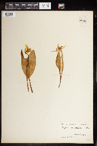 Erythronium americanum Ker Gawler 960312[1318775]Stork, H.E. United States, New York |
MIN:Plants | 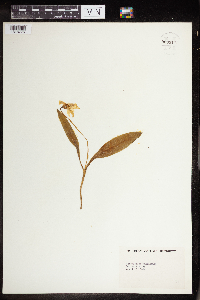 Erythronium americanum Ker Gawler 960311[1318776] 1894-04-10 United States, Kentucky |
MIN:Plants | 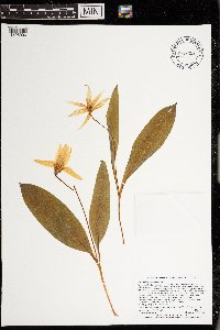 Erythronium americanum Ker Gawler 973353[1398906]Lee, Michael MDL58032012-04-27 United States, Minnesota, Winona, Whitewater Wildlife Management Area; Along the South Fork Whitewater River six miles northeast of St. Charles., 44.0176301262 -91.9626767752, 305m |
MIN:Plants | 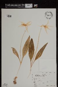 Erythronium montanum S. Watson 716921[1299153]Boedigheimer, S. s.n.1968-04-15 United States, Oregon, Marion, Marion Co.;;;;, 44.749011 -122.942314 |
MIN:Plants | Erythronium montanum S. Watson 567330[]Hunnewell, F. 44021916-08-06 United States, Washington, Pierce, Mount Rainier National Park;Mount Rainier National Park |
MIN:Plants | Erythronium montanum S. Watson 584632[]Morean, Edith 1801962-08-07 United States, Washington, Clallam, Olympic National Park, Between Obstruction Point and Hurricane Ridge.;Olympic National Park |
MIN:Plants | Erythronium montanum S. Watson 393092[]Stork, H.; et al. 681923-07-29 United States, Washington, Pierce, Ranier [sic] Natl Park;Mount Rainier National Park, 2134m |
MIN:Plants | Erythronium montanum S. Watson 582002[]Morean, Edith 1251962-08-09 United States, Washington, Clallam, Olympic National Park, side of Bogachiel Peak.;Olympic National Park |
MIN:Plants | Erythronium montanum S. Watson 88482[]Piper, C. 21181895-08-01 United States, Washington, Pierce, Mt. Rainier;Mount Rainier National Park, 1981m |
MIN:Plants | Erythronium montanum S. Watson 88483[]Elmer, A.D.E. 24961900-06-00 United States, Washington, Clallam, Olympic Mts. [Olympic National Park] |
MIN:Plants | Erythronium montanum S. Watson 415138[]Stork, H.; et al. 731923-07-29 United States, Washington, Pierce, Ranier [sic] Natl Park;Mount Rainier National Park |
MIN:Plants | Erythronium montanum S. Watson 290901[]Thompson, J. 54591930-07-27 United States, Washington, Pierce, Spray Park, Mt. Rainier...Pierce Co.;Mount Rainier National Park, 1829m |
MIN:Plants | Erythronium montanum S. Watson 88485[]Allen, O. 831894-07-23 United States, Washington, Pierce, Cascade Mountains...Goat Mts, near Mt. Rainier.;Mount Rainier National Park, 1829m |
MIN:Plants | Erythronium montanum S. Watson 581982[]Morean, Edith 1241962-08-07 United States, Washington, Clallam, Olympic National Park, Between Obstruction Point and Hurricane Ridge.;Olympic National Park |
MIN:Plants | Brodiaea coronaria (Salisbury) Engler 236540[]Congdon, J. s.n.1891-07-24 United States, California, Mariposa, Yosemite Valley, Mariposa County;Yosemite National Park |
MIN:Plants | Prosartes hookeri Torrey 88335[]Elmer, A.D.E. 24971900-07-00 United States, Washington, Clallam, Olympic Mts. [Olympic National Park] |
MIN:Plants | Calochortus gunnisonii S. Watson 351316[]Engleman, J.; et al. 33931935-08-06 United States, Colorado, Rocky Mountain National Park;Rocky Mountain National Park |
MIN:Plants | Calochortus gunnisonii S. Watson 279134[]Goodman, G.; Hitchcock, C. 13551930-06-21 United States, Colorado, Montezuma, Entrance to Mesa Verde National Park.;Mesa Verde National Park, 2134m |
MIN:Plants |  Calochortus gunnisonii S. Watson 960232[1318763] 1251944-07-03 United States, Colorado, north rim along rock springs road, mesa verde |
MIN:Plants |  Calochortus gunnisonii S. Watson 0968657[1391248]Kathy Shea 4361981-07-23 United States, Colorado, Boulder, U of CO, Mt. Research Station; 10 km N. of Nederland |
MIN:Plants | Erythronium albidum Nuttall 435291[]Smith, Welby 151251989-05-02 United States, Minnesota, Rice, Rice County ... Riverbend Nature center in Faribault ... north side of the Straight River ... NW1/4 SW1/4 sec. 4, T 109N R 20W. 109N 20W 4, 44.2741667 -93.24 |
MIN:Plants | Erythronium albidum Nuttall 454517[]Biederman, L. 0061999-04-21 United States, Minnesota, Rice, Rice County ... Nerstrand Big Woods State Park ... T110N R19W NE SE 09;Nerstrand Woods State Park;110N;19W;09, 44.349161 -93.110599 |
MIN:Plants | Erythronium albidum Nuttall 477531[]Smith, Welby 166451990-05-21 United States, Minnesota, Steele, Steele County ... Kaplan Woods City Park, on the south side of Owatonna ... north side of the Straight River ... T107N R20W NE1/4 of NW1/4 of Sec 21. 107N 20W 21, 44.0644444 -93.235 |
MIN:Plants | Erythronium albidum Nuttall 454101[]Gellerman, Joanne 008 JLG1994-04-26 United States, Minnesota, Freeborn, Myre Big Island State Park. Myre Big Island State Park. Freeborn County; T: 102N R: 20W Sec: 19 Quarter Sec: NW; About 65 yards south of outdoor chapel, on east side of trail.. 102N 20W 19, 43.624946 -93.289476 |
MIN:Plants | Erythronium albidum Nuttall 473059[]Lee, Michael MDL16221997-05-06 United States, Minnesota, Wabasha, Dorer Memorial Hardwood State Forest. Wabasha County ... Along the North Fork Zumbro River near its mouth on the Zumbro River 3-1/2 miles southwest of Zumbro Falls ... T109N R14W SE1/4 of SW1/4 Sec. 10. 109N 14W 10, 44.212766 -92.479382 |
MIN:Plants | Erythronium albidum Nuttall 907568[]Lee, Michael MDL41892006-04-26 United States, Minnesota, Todd, Todd County ... West side of Molly Lake, two miles southeast of Burtrum ... T128N R32W Center of SE1/4 of SW1/4 Sec. 36;;128N;32W;36, 45.853014 -94.65401 |
MIN:Plants | Erythronium albidum Nuttall 919469[]Smith, Welby 220461993-05-07 United States, Minnesota, Nicollet, Seven Mile Creek County Park. Nicollet County...7-Mile Creek County Park, about 7 miles north of Mankato...7-mile Creek...T109N R27W NW1/4 of NE1/4 of Sec 11. 109N 27W 11, 44.2680556 -94.0344444 |
MIN:Plants | Erythronium albidum Nuttall 511427[]Kaul, R. 67231990-05-01 United States, Minnesota, Steele, Steele County ... along Straight River.;;107N;20W;, 44.084579 -93.230139 |
MIN:Plants | Erythronium albidum Nuttall 610875[]Massey, J. 19131968-05-17 United States, Oklahoma, Cleveland, Cleveland Co. ... Pauline's Patch, 3 mi. E. of Norman. |
MIN:Plants | Erythronium albidum Nuttall 427315[]Mensing, D. 96-00011996-05-14 United States, Minnesota, Fillmore, Fillmore Co. ... T104N R9W NW1/4 of the SE1/4 of S35 ... along Root River;Dorer Memorial Hardwood State Forest;104N;09W;35, 43.76595 -91.877505 |
MIN:Plants | Erythronium albidum Nuttall 457169[]Boe, J.; Estes, Carol 94051211 United States, Minnesota, Cass, Chippewa National Forest / Leech Lake Indian Reservation. Cass County ... Bear Island in Leech Lake. Chippewa National Forest. Walker Dist, Comp. 32. Chipp. Nat. Forest T142N R29W SE1/4 of NW1/4 of Sec 2. 142N 29W 2, 47.136066 -94.305252 |
MIN:Plants | Erythronium albidum Nuttall 475495[]Smith, Welby 151301989-05-12 United States, Minnesota, Scott, Minnesota Valley National Wildlife Refuge. Scott County ... The Louisville swamp area, in the Minnesota Valley National Wildlife Refuge, about six miles south of Shakopee ... NW1/4 SE1/4 section 29, T 115N R 23W. 115N 23W 29, 44.7355537 -93.5988922 |
MIN:Plants | Erythronium albidum Nuttall 514488[]Myhre, K. 35221993-05-06 United States, Minnesota, Pine, Banning State Park. Pine County ... located on the south side of highway 23 as it crosses the Kettle River, east bank ... T43N R20W NW1/4 of SE1/4 of Sec 26. 043N 20W 26, 46.180318 -92.834207 |
MIN:Plants | Erythronium albidum Nuttall 514511[]Myhre, K. 2381991-05-10 United States, Minnesota, Aitkin, Aitkin County ... Located on the north side of highway 18 ... T 45N R 27W SW1/4 of SW1/4 of sec 33;;045N;27W;33, 46.332832 -93.76359 |
MIN:Plants | Erythronium albidum Nuttall 833488[]Juhnke, C. 0091991-05-07 United States, Minnesota, Fillmore, Forestville State Park. Fillmore Co. T102N R12W Sec.19 SE SE SE ... NW of house at Mystery Cave I;Forestville State Park;102N;12W;19, 43.623689 -92.318983 |
MIN:Plants | Erythronium albidum Nuttall 833919[]Smith, Welby 140631988-05-20 United States, Minnesota, Kanabec, Kanabec Co. On the W side of the Snake River, just S of the Hwy 3 crossing. NE1/4 NW1/4 sec 22, T41N R23W;;041N;23W;22, 46.0238876 -93.2333298 |
MIN:Plants | Erythronium albidum Nuttall 840317[]Dahle, R. 940251994-05-19 United States, Minnesota, Nicollet, Nicollet Co. Swan Lake WMA (North Star Supplement), about 4 mi S of Nicollet. T109N R28W SW1/4 of NE1/4 of sec 28.;Swan Lake Wildlife Management Area;109N;28W;28, 44.217999 -94.200153 |
MIN:Plants | Erythronium albidum Nuttall 840446[]Smith, Welby 125891987-04-18 United States, Minnesota, Goodhue, Grace Nature Preserve, The Nature Conservancy. Goodhue County ... Grace Nature Preserve, about 1 mi SW of Kenyon ... S side of the Zumbro River; NW1/4 SW1/4 sec.8, T109N R18W. 109N 18W 8, 44.2577782 -93.0180588 |
MIN:Plants | Erythronium albidum Nuttall 840505[]Smith, Welby 126181987-05-02 United States, Minnesota, Mille Lacs, Mille Lacs Co. Mille Lacs State Wildlife Management Area, about 11 mi N of Bock; SE1/4 NE1/4 sec.24, T40N R26W;Mille Lacs Wildlife Management Area;040N;26W;24, 45.9472237 -93.5199966 |
MIN:Plants | Erythronium albidum Nuttall 226856[]Rosendahl, C. 44451924-06-08 United States, Minnesota, Aitkin, North end of Lake Mille Lacs.;;;;, 46.326903 -93.784975 |
MIN:Plants | Erythronium albidum Nuttall 226857[]Butters, F.; et al. 44121924-05-04 United States, Minnesota, Wabasha, Zumbro River, below Wabasha. Wabasha County;Dorer Memorial Hardwood State Forest;110N;10W;, 44.249964 -91.954363 |
MIN:Plants | Erythronium albidum Nuttall 255393[]Sheldon, Edmund s.n.1895-05-00 United States, Minnesota, Ramsey, Larson's Island, Ramsey Co.;;;;, 45.018032 -93.092742 |
MIN:Plants | Erythronium albidum Nuttall 270073[]Wheeler, William 11896-05-00 United States, Minnesota, Houston, Winnebago Valley;Dorer Memorial Hardwood State Forest;;;, 43.66667 -91.50056 |
MIN:Plants | Erythronium albidum Nuttall 271188[]Butters, F. s.n.1895-04-26 United States, Minnesota, Hennepin, Island in Mississippi, just above Minnehaha [Falls] Minneapolis.;Minnehaha Falls Park;028N;23W;17, 44.919064 -93.209944 |
MIN:Plants | Erythronium albidum Nuttall 278356[]Roberts, Thomas s.n.1878-04-18 United States, Minnesota, Hennepin, Minneapolis;;029N;24W;25, 44.96996 -93.23702 |
MIN:Plants | Erythronium albidum Nuttall 278357[]Roberts, Thomas s.n.2000-05-00 United States, Minnesota, Hennepin, Minneapolis;;029N;24W;25, 44.96996 -93.23702 |
MIN:Plants | Erythronium albidum Nuttall 281655[]Budde, C. s.n.1893-05-09 United States, Minnesota, Blue Earth, W Mankato.;;108N;27W;00, 44.162588 -94.039641 |
MIN:Plants | Erythronium albidum Nuttall 281664[]Dayton, E. 381944-05-13 United States, Minnesota, Goodhue, Belle Creek Valley;;;;, 44.550382 -92.724728 |
MIN:Plants | Erythronium albidum Nuttall 281894[]Lange, D. s.n.1931-04-29 United States, Minnesota, Pine, Pine County ... On N side of Snake River, 2 mi E of Pine City.;;039N;21W;00, 45.838601 -92.914452 |
MIN:Plants | Erythronium albidum Nuttall 301930[]Quick, R. 21928-05-00 United States, Minnesota, St. Croix River Road;;;;, 45.41836 -92.610768 |
MIN:Plants | Erythronium albidum Nuttall 348792[]Nielsen, E. 24001934-05-08 United States, Minnesota, Olmsted, 10 mi SW of Rochester.;;;;, 43.919127 -92.612326 |
MIN:Plants | Erythronium albidum Nuttall 351300[]Rosendahl, C.; et al. 18601933-05-15 United States, Minnesota, Goodhue, 2 mi south of Cannon Falls. Goodhue Co.;;112N;17W;, 44.486426 -92.934203 |
MIN:Plants | Erythronium albidum Nuttall 356754[]Moore, John; et al. 123221940-04-28 United States, Minnesota, Carver, Carver County ... Hwy 212, 1-1/2 mi west of Norwood.;;115N;26W;00, 44.769163 -93.958375 |
MIN:Plants | Erythronium albidum Nuttall 367524[]Moore, John; et al. 124091940-05-17 United States, Minnesota, Freeborn, Freeborn County ... T103N R22W Sec. 6, North slope above creek.;;103N;22W;06, 43.753088 -93.518567 |
MIN:Plants | Erythronium albidum Nuttall 367598[]Moore, John; et al. 123871940-05-16 United States, Minnesota, Steele, Steele County ... South edge of Owatonna;;107N;20W;00, 44.084579 -93.230139 |
MIN:Plants | Erythronium albidum Nuttall 367690[]Moore, John; et al. 125261940-05-18 United States, Minnesota, Fillmore, 7 mi south west of Preston, Fillmore County;;102N;11W;, 43.56885 -92.083216 |
MIN:Plants | Erythronium albidum Nuttall 367776[]Moore, John; et al. 124391940-05-17 United States, Minnesota, Mower, Mower County ... Red Cedar River, T 101N R 18W Sec. 17;;101N;18W;17, 43.547923 -93.013864 |
MIN:Plants | Erythronium albidum Nuttall 369715[]Moore, John; et al. 139511941-05-11 United States, Minnesota, Fillmore, Fillmore County ... East of the road, 4 mi south west of Peterson.;Dorer Memorial Hardwood State Forest;104N;09W;, 43.803933 -91.908438 |
MIN:Plants | Erythronium albidum Nuttall 369942[]Moore, John; et al. 140891941-05-24 United States, Minnesota, Chisago, Chisago County ... St. Croix River. T 137N [sic] R 21W Sec. 19;Saint Croix National Riverway;037N;21W;19, 45.499465 -92.887743 |
MIN:Plants | Erythronium albidum Nuttall 369948[]Moore, John 140831941-05-24 United States, Minnesota, Chisago, Chisago County ... 1-1/[?] mi north east of Rush City. T 37N R 21W Sec. 14;;037N;21W;14, 45.694929 -92.929475 |
MIN:Plants | Erythronium albidum Nuttall 371097[]Moore, John; et al. 138371941-05-10 United States, Minnesota, Olmsted, Olmsted County ... Along branch of the Root River, west of the bridge, about 2 mi southeast of Marion.;Dorer Memorial Hardwood State Forest;105N;13W;, 43.923088 -92.319777 |
MIN:Plants | Erythronium albidum Nuttall 371629[]Lakela, Olga 42951941-05-10 United States, Minnesota, Carlton, Carlton County ... Jay Cooke State Park, South of St. Louis River.;Jay Cooke State Park;048N;16W;, 46.649665 -92.330748 |
MIN:Plants | Erythronium albidum Nuttall 374028[]Linnaean Club, U of M, 1821940-05-19 United States, Minnesota, Rice, Nerstrand Woods. Rice Co.;Nerstrand Woods State Park;110N;19W;, 44.341172 -93.111247 |
MIN:Plants | Erythronium albidum Nuttall 374029[]Linnaean Club, U of M, 1041940-05-04 United States, Minnesota, Rice, Nerstrand Woods. Rice Co.;Nerstrand Woods State Park;110N;19W;, 44.341172 -93.111247 |
MIN:Plants | Erythronium albidum Nuttall 385490[]Rosendahl, C. 77231945-05-06 United States, Minnesota, Goodhue, 1-1/2 mi west of Kenyon.;;109N;18W;, 44.272183 -93.015824 |
MIN:Plants | Erythronium albidum Nuttall 386898[]Hero, C. s.n.1940-05-20 United States, Minnesota, Renville, Near Minnesota River, 12 mi southwest of Renville. Renville Co.;;;;, 44.670997 -95.302422 |
MIN:Plants | Erythronium albidum Nuttall 386908[]Hero, C. s.n.1940-05-05 United States, Minnesota, Renville, Renville County ... Near Carl Olson's Farm, about 13 mi W-SW of Renville.;;;;, 44.758605 -95.47588 |
MIN:Plants | Erythronium albidum Nuttall 396878[]Harris, Bruce; et al. 8991947-05-14 United States, Minnesota, Clay, Clay County ... Buffalo River, Moorhead, 4 mi south;;;;, 46.806328 -96.775156 |
MIN:Plants | Erythronium albidum Nuttall 410029[]Anderson, G. 681880-05-04 United States, Minnesota, Hennepin, Minneapolis S.W.D.;;;;, 44.979965 -93.263836 |
MIN:Plants | Erythronium albidum Nuttall 421404[]Jacobs, D. 4091947-05-08 United States, Minnesota, Blue Earth, Glenwood Ave ravines, Mankato.;;108N;27W;, 44.163578 -93.9994 |
MIN:Plants | Erythronium albidum Nuttall 424504[]Lakela, Olga 123341951-05-13 United States, Minnesota, Saint Louis, St. Louis County ... Whiteface River terrace at the bridge of # 29.;;;;, 47.16401 -92.527809 |
MIN:Plants | Erythronium albidum Nuttall 442047[]Moore, John; Huff, N. 184361946-04-17 United States, Minnesota, Goodhue, Goodhue County ... Along creek, 1-1/2 mi south west of Kenyon.;;109N;18W;, 44.250462 -92.985484 |
MIN:Plants | Erythronium albidum Nuttall 442176[]Moore, John; et al. 194771947-06-07 United States, Minnesota, Morrison, Morrison County ... 5 mi south west of Randall.;;130N;31W;00, 46.039864 -94.577431 |
MIN:Plants |  Erythronium albidum Nuttall 442252[1181110]Moore, John W. 194141947-05-29 United States, Minnesota, Pine, Kettle River;Saint Croix State Park;;;, 46.145255 -92.860815 |
MIN:Plants | Erythronium albidum Nuttall 500787[]Moore, John 204851950-05-24 United States, Minnesota, Freeborn, Freeborn County ... 1 mi north of Emmons.;;101N;22W;, 43.516384 -93.488268 |
MIN:Plants | Erythronium albidum Nuttall 527393[]Lakela, Olga 172131954-05-21 United States, Minnesota, Saint Louis, St. Louis County ... Swan River terrace, north of Toivola, Hwy No 5.;;055N;20W;00, 47.271167 -92.888673 |
MIN:Plants | Erythronium albidum Nuttall 542613[]Moore, John 214311952-05-06 United States, Minnesota, Murray, Murray County ... Lake Shetek State Park, along the north shore of peninsula.;Lake Shetek State Park;108N;40W;, 44.124433 -95.693123 |
MIN:Plants | Erythronium albidum Nuttall 574803[]Moore, John 244431959-05-05 United States, Minnesota, Blue Earth, Blue Earth County ... 3 mi north of Mankato.;;109N;26W;, 44.207028 -93.9994 |
MIN:Plants | Erythronium albidum Nuttall 585242[]Moore, John 258881962-05-08 United States, Minnesota, Houston, Houston County ... 1 mi east of Houston, along the Root River.;Dorer Memorial Hardwood State Forest;104N;06W;, 43.763298 -91.548421 |
MIN:Plants | Erythronium albidum Nuttall 592226[]Westkaemper, Remberta s.n.1963-05-00 United States, Minnesota, Stearns, Stearns Co. ... St. Cloud, St. Cloud Hospital river bank.;;;;, 45.557945 -94.16324 |
Google Map
Google Maps is a web mapping service provided by Google that features a map that users can pan (by dragging the mouse) and zoom (by using the mouse wheel). Collection points are displayed as colored markers that when clicked on, displays the full information for that collection. When multiple species are queried (separated by semi-colons), different colored markers denote each individual species.