University of Minnesota
http://www.umn.edu/
612-625-5000
http://www.umn.edu/
612-625-5000
Minnesota Biodiversity Atlas
Bell Museum
Dataset: MIN-Plants
Taxa: Linderniaceae
Search Criteria: excluding cultivated/captive occurrences
Bell Museum plants | |
 MIN:Plants | Lindernia dubia (L.) Pennell 438485[]Smith, Welby 258971995-08-23 United States, Minnesota, Yellow Medicine, Upper Sioux Agency State Park. Yellow Medicine County...In Upper Sioux Agency State Park. On the floodplain of the Minnseota River about 5 miles east-southeast of Granite Falls...T 115N R 38W SE1/4 of NW1/4 of Sec 29. 115N 38W 29, 44.7405556 -95.4505556 |
MIN:Plants | Lindernia dubia (L.) Pennell 699591[]Ziegler, S.; et al. 20231975-07-24 United States, Wisconsin, La Crosse, LaCrosse Co.; Island 18; Mississippi River-mile #693.3; T15N R7W Sec 29 ... Island on E side of main channel;Upper Mississippi National Wildlife Refuge;015N;07W;29, 192m |
MIN:Plants | Lindernia dubia (L.) Pennell 911759[]Cholewa, A. 27002009-09-01 United States, Minnesota, Scott, Minnesota Valley National Wildlife Refuge. Scott County, Minnesota Valley Wildlife Refuge, Minnesota River at highway 9, Thompson Ferry public boat ramp. T114N R23W Sec 7. 114N 23W 7, 44.696212 -93.624265 |
MIN:Plants | Lindernia dubia (L.) Pennell 909960[]Lee, Michael; et al. MDL45472007-09-05 United States, Minnesota, Wadena, Wadena County...Along the Leaf River, 1/4-mile upstream from its mouth on the Crow Wing River, five miles north-northwest of Staples...T134N R33W SE1/4 of NW1/4 of SW1/4 Sec. 11, N1/2 of SE1/4 of SW1/4 Sec. 11...UTM's: 5143552N 360384E, 5143389N 360677E. 134N 33W 11, 46.433594 -94.815538 |
MIN:Plants | Lindernia dubia (L.) Pennell 427667[]Smith, Welby 136791987-07-31 United States, Minnesota, Washington, Washington County...Island in Baldwin Lake, on the Mississippi River bottoms, about 3 mi S of St. Paul Park SW1/4 NE1/4 sec 35, T27N R22W. 027N 22W 35, 44.7866667 -93.015 |
MIN:Plants | Lindernia dubia (L.) Pennell 427671[]Smith, Welby 139721987-09-26 United States, Minnesota, Sherburne, Sherburne Co. In Sherburne National Wildlife Refuge, about 3 mi NE of Orrock. NE1/4 SW1/4 sec 34, T35N R27W;Sherburne National Wildlife Refuge;035N;27W;34, 45.4791679 -93.6875 |
MIN:Plants | Lindernia dubia (L.) Pennell 429367[]Smith, Welby 145951988-07-22 United States, Minnesota, Washington, Washington Co.; In Afton State Park, about 3 miles south of the town of Afton. NE1/4 NW1/4 section 2, T 27N R 20W.;Afton State Park;027N;20W;2, 44.860178 -92.773329 |
MIN:Plants | Lindernia dubia (L.) Pennell 440467[]Smith, Welby 149131988-08-17 United States, Minnesota, Meeker, Meeker Co. About 3.5 mi W of Kingston; along the North Fork Crow River, near the Hwy.27 crossing; SW1/4 NE1/4 sec.13, T1 Meeker Co. About 3.5 mi W of Kingston; along the North Fork Crow River, near the Hwy.27 crossing; SW1/4 NE1/4 sec.13, T120N R30W. 120N 30W 13, 45.2036095 -94.3880539 |
MIN:Plants | Lindernia dubia (L.) Pennell 460553[]Smith, Welby 146391988-07-25 United States, Minnesota, Kanabec, Kanabec County...On the west bank of the Snake River, just south of the Highway 3 crossing; NE1/4 NW1/4 section 22, T 341N R 23W. 041N 23W 22, 46.0238889 -93.2333333 |
MIN:Plants | Lindernia dubia (L.) Pennell 460940[]Delaney, B. 97126.01997-09-09 United States, Minnesota, Carlton, CArlton Co.; along the St. Louis River at the mouth of Crystal Creek; 1.5 miles north of Carlton. T49N R16W NW NE sec 31;;049N;16W;31, 46.68512 -92.417555 |
MIN:Plants | Lindernia dubia (L.) Pennell 471853[]Smith, Welby 143561988-06-26 United States, Minnesota, Aitkin, Aitkin Co. On the N bank of the Mississippi River, about 2 1/2 mi SW of Palisade; NW1/4 NW1/4 sec.33, T49N R25W;;049N;25W;33, 46.6933327 -93.523613 |
MIN:Plants | Lindernia dubia (L.) Pennell 505846[]Smith, Welby 146801988-08-04 United States, Minnesota, Mille Lacs, Mille Lacs Co.; About 11 miles north of Milaca; Rum River; SW1/4 SE1/4 section 26, T 40N R 27W;;040N;27W;26, 45.9249992 -93.6680527 |
MIN:Plants | Lindernia dubia (L.) Pennell 840554[]Smith, Welby 135301990-07-18 United States, Minnesota, Sherburne, Sherburne National Wildlife Refuge. Sherburne County ... Sherburne National Wildlife Refuge; about 4 mi E of Orrock. Along the banks of the St. Francis River N of the Hwy. 4 crossing. SE1/4 SE1/4 sec 11, T34N R27W. 034N 27W 11, 45.4449997 -93.6505585 |
MIN:Plants | Lindernia dubia (L.) Pennell 841178[]Smith, Welby 13334A1987-07-07 United States, Minnesota, Washington, Washington Co. Island in the St. Croix River, about 2 mi NE of Scandia; SE1/4 SE1/4 sec.7, T32N R19W;;032N;19W;7, 45.2675018 -92.7555542 |
MIN:Plants | Lindernia dubia (L.) Pennell 841206[]Smith, Welby 137421987-08-06 United States, Minnesota, Washington, Washington Co. Island in Conoly Lake on the Mississippi River Bottoms, about 2 mi W of Point Douglas; SE1/4 SW1/4 sec.8, Washington Co. Island in Conoly Lake on the Mississippi River Bottoms, about 2 mi W of Point Douglas; SE1/4 SW1/4 sec.8, T26N R20W. 026N 20W 8, 44.7508316 -92.8344421 |
MIN:Plants | Lindernia dubia (L.) Pennell 485976[]Rand, Edward s.n.1889-08-16 United States, Maine, Hancock, Mount Desert Island ... mill stream, Somesville |
MIN:Plants | Lindernia dubia (L.) Pennell 482542[]Smith, Welby 259191995-08-23 United States, Minnesota, Renville, Skalbakken County Park. Renville County...In Skalbakken County Park. On the floodplain of the Minnesota River, about 6 miles east of Granite Falls...T 115N R 38W SE1/4 of SW1/4 of Sec 27 Falls...T 115N R 38W SE1/4 of SW1/4 of Sec 27. 115N 38W 27, 44.7347222 -95.4169444 |
MIN:Plants | Lindernia dubia (L.) Pennell 920526[]Smith, Welby 258541995-08-17 United States, Minnesota, Hennepin, Hennepin County ... About 1/4 mile downstream (south) of the Lake Street Bridge in Minneapolis ... Mississippi River ... T28N R23W SE1/4 of NW1/4 of Sec 5. 028N 23W 5, 44.9438889 -93.2022222 |
MIN:Plants | Lindernia dubia (L.) Pennell 910872[]Smith, Welby 253861994-09-02 United States, Minnesota, Dodge, Dodge County...Dodge Center Creek City Park, about 1.5 miles west-northwest of Dodge Center...Dodge Center Creek... T 107N R 17W SW1/4 of SW1/4 of Sec 28 T 107N R 17W SW1/4 of SW1/4 of Sec 28. 107N 17W 28, 44.0405556 -92.8780556 |
MIN:Plants | Lindernia dubia (L.) Pennell 438601[]Juhnke, C. 246 CMJ FRO2000-08-29 United States, Minnesota, Goodhue, Frontenac State Park. Frontenac State Park Goodhue County ... Along Well's Creek 100 meters south of trail bridge on way to Sandy Point ... T112N R13W SE NW NE 13. 112N 13W 13, 44.50502 -92.31891 |
MIN:Plants | Lindernia dubia (L.) Pennell 931588[]Lee, Michael MDL48362008-09-15 United States, Minnesota, Cass, Along the Crow Wing River between the Highway 210 bridge and the mouth of Mosquito Creek, on the outskirts of Motley. UTM: 5133394N 373880E. SE1/4 of SW1/4 of section;;133N;31W;07, 46.3423739 -94.6389256 |
MIN:Plants | Lindernia dubia (L.) Pennell 938129[]Palmstrom, L.; Hamilton, R. 2013-42013-07-12 United States, Minnesota, Hennepin, Edina High School, 6754 Valley View Road, Edina on lower athletic field adjacent to Nine Mile Creek.;;;;, 44.88304 -93.376616 |
MIN:Plants | Lindernia dubia (L.) Pennell 774107[]Smith, Welby R. 298582006-08-28 United States, Minnesota, Dakota, Black Dog Lake in the Minnesota River bottoms, just north of Burnsville. SE1/4 of NW1/4 of section;Chippewa National Forest;027N;24W;27, 44.8002778 -93.2825 |
MIN:Plants | Lindernia dubia (L.) Pennell 388693[]Smith, Welby R. 298682006-08-29 United States, Minnesota, Scott, Louisville Swamp, about 7 miles southwest of Shakopee. NE of SE of section;;115N;23W;31, 44.726293 -93.627916 |
MIN:Plants | Lindernia dubia (L.) Pennell 941968[]Smith, Welby R. 299252006-09-29 United States, Minnesota, Winona, Lower Twin Lake in the Mississippi River backwaters (Pool #5A), about opposite Minnesota City (Minnesota) and Fountain City (Wisconsin). NE of SW of section;;107N;07W;06, 44.0967191 -91.7136749 |
MIN:Plants | 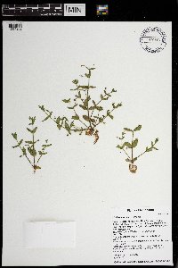 Lindernia dubia (L.) Pennell 970713[1394202]Timothy J. S. Whitfeld 30742021-07-29 United States, Minnesota, Pine, Kettle River Scientific and Natural Area, east of the Kettle River, north of Highway 48, 4.5 miles east of intersection with Interstate 35, 46.019368 -92.850584, 282m |
MIN:Plants | Lindernia dubia (L.) Pennell MPCA_Dummy76[]Michael Bourdaghs 2021-07-06 United States, Minnesota, Washington, Collected as part of the US Environmental Protection Agency National Wetland Condition Assessment (EPA siteID NWC21-MN-10078) and MN Pollution Control Agency MN Wetland Condition Assessment (MPCA siteID 16WASH219), 45.03118742 -92.89648876 |
MIN:Plants | 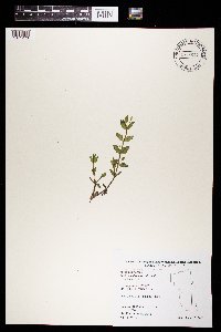 Lindernia dubia (L.) Pennell 969684[1371273]B. Bartodziej 37-01 B2001-08-07 United States, Minnesota, Ramsey, Drainage Area: SB18-07, 45.009532 -93.010357 |
MIN:Plants | 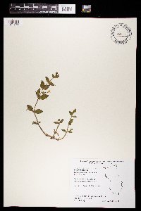 Lindernia dubia (L.) Pennell 969685[1371274]B. Bartodziej 19-00 B2000-08-02 United States, Minnesota, Ramsey, Subwatershed Num.: BL-111, 44.981377 -92.999892 |
MIN:Plants | 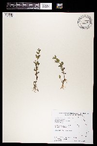 Lindernia dubia (L.) Pennell 969686[1371275]B. Bartodziej 8-00 B2000-08-01 United States, Minnesota, Ramsey, Subwatershed Num.: KELL-05, 45.009582 -93.030445 |
MIN:Plants | Lindernia dubia (L.) Pennell []Timothy J. S. Whitfeld 37512023-08-12 United States, Minnesota, Washington, Southern tip of Upper Grey Cloud Island on north side of channel from main channel of the Mississippi River and Baldwin Lake, 44.78453 -93.016184, 213m |
MIN:Plants |  Lindernia dubia (L.) Pennell 975860[1404914]Dunevitz, Hannah L. 10311994-09-02 United States, Minnesota, Dakota, In Gores Pool #3 Wildlife Management Area, Floodplain between the Mississippi River to the north and the Vermillion River to the south. Three miles east of Highway 61 and 0.2 miles northeast of the floodplain forest's south edge., 44.725467 -92.789152 |
MIN:Plants | Lindernia dubia var. anagallidea (Michaux) T.S. Cooperrider 477035[]Wheeler, Gerald 175371997-09-01 United States, Minnesota, Renville, Renville County ... W side of Morton, Morton Outcrop complex ... SW1/4 NW1/4 NW1/4 Sec. 31 T113N R34W;;113N;34W;31, 44.55135 -94.984439 |
MIN:Plants | Lindernia dubia var. anagallidea (Michaux) T.S. Cooperrider 475425[]Lehtinen, R. 4754251995-08-24 United States, Minnesota, Jackson, Jackson Co, T103N R36W SW1/4 of the NE1/4 of S36; Toe Wildlife Management Area.;Toe Wildlife Management Area;103N;36W;36, 43.680974 -95.104034 |
MIN:Plants | Lindernia dubia var. anagallidea (Michaux) T.S. Cooperrider 475429[]Schik, K. 95-2291995-09-11 United States, Minnesota, Nicollet, Floodplain forest of the Minnesota River at Fritsche Creek Wildlife Management Area. Nicollet Co, T110N R30W NW1/4 of the NW1/4 of S17... T110N R30W S17, 44.33608 -94.459966 |
MIN:Plants | Lindernia dubia var. anagallidea (Michaux) T.S. Cooperrider 475430[]Husveth, J. 95-45211995-08-31 United States, Minnesota, Wabasha, Wabasha Co, T110N R12W SW1/4 of the SE1/4 of S27...bank of the Zumbro River.;Dorer Memorial Hardwood State Forest;110N;12W;27, 44.212766 -92.479382 |
MIN:Plants | Lindernia dubia var. anagallidea (Michaux) T.S. Cooperrider 838334[]Smith, Welby 177561990-08-07 United States, Minnesota, Red Lake, Red Lake County ... At 'Old Crossing Treaty State Wayside Park'. On the N bank of the Red Lake River, about 6 miles W of the town of Red Lake Falls ... T151N R45W SE1/4 of SW1/4 of Sec 27. 151N 45W 27, 47.8666649 -96.4113922 |
MIN:Plants | Lindernia dubia var. anagallidea (Michaux) T.S. Cooperrider 188015[]Rosendahl, C. 43301922-08-00 United States, Minnesota, Ramsey, Snail Lake;Snail Lake Vadnais Lake County Park;030N;23W;, 45.070121 -93.120131 |
MIN:Plants | Lindernia dubia var. anagallidea (Michaux) T.S. Cooperrider 271329[]Frost, W. s.n.1892-08-00 United States, Minnesota, Kandiyohi, Spicer;;N;;, 45.23302 -94.940009 |
MIN:Plants | Lindernia dubia var. anagallidea (Michaux) T.S. Cooperrider 272220[]Rosendahl, C. 27081913-07-14 United States, Minnesota, Dakota, Small lake N of Orchard Lake;;114N;20W;, 44.710588 -93.307932 |
MIN:Plants | Lindernia dubia var. anagallidea (Michaux) T.S. Cooperrider 272225[]Sandberg, John s.n.1890-07-00 United States, Minnesota, Hennepin, [no further data];;;;, 45 -93.47 |
MIN:Plants | Lindernia dubia var. anagallidea (Michaux) T.S. Cooperrider 272226[]Burglehaus, F. s.n.1891-09-00 United States, Minnesota, Hennepin, Hennepin co; Wet sandy shores;;N;;, 45.004576 -93.476884 |
MIN:Plants | Lindernia dubia var. anagallidea (Michaux) T.S. Cooperrider 272227[]Herrick, C. s.n.1878-07-00 United States, Minnesota, Hennepin, Minneapolis;;N;;, 44.979965 -93.263836 |
MIN:Plants | Lindernia dubia var. anagallidea (Michaux) T.S. Cooperrider 272230[]Sheldon, Edmund S32531892-07-00 United States, Minnesota, Mille Lacs, Milaca;;N;;, 45.755799 -93.654408 |
MIN:Plants | Lindernia dubia var. anagallidea (Michaux) T.S. Cooperrider 273455[]Stevens, O. s.n.1928-08-15 United States, Minnesota, Clay, Georgetown;;N;;, 47.08 -96.793056 |
MIN:Plants | Lindernia dubia var. anagallidea (Michaux) T.S. Cooperrider 278215[]Roberts, Thomas s.n.1877-08-00 United States, Minnesota, Hennepin, Minneapolis;;N;;, 44.979965 -93.263836 |
MIN:Plants | Lindernia dubia var. anagallidea (Michaux) T.S. Cooperrider 306856[]Moyle, J. 20471935-08-29 United States, Minnesota, Anoka, State Game Refuge;Carlos Avery Wildlife Management Area;N;;, 45.313817 -93.080299 |
MIN:Plants | Lindernia dubia var. anagallidea (Michaux) T.S. Cooperrider 347135[]Moyle, J. 31961938-07-28 United States, Minnesota, Kandiyohi, Near Willmar;;N;;, 45.121908 -95.043342 |
MIN:Plants | Lindernia dubia var. anagallidea (Michaux) T.S. Cooperrider 347224[]Moyle, J. 31651938-08-06 United States, Minnesota, Washington, Washington Co.; Echo Lake;;030N;21W;17, 45.086526 -92.959157 |
MIN:Plants | Lindernia dubia var. anagallidea (Michaux) T.S. Cooperrider 362303[]Rosendahl, C. 67861936-09-13 United States, Minnesota, Goodhue, Shore of Cannon River;;N;;, 44.585648 -92.557156 |
MIN:Plants | Lindernia dubia var. anagallidea (Michaux) T.S. Cooperrider 362304[]Rosendahl, C.; Butters, F. 67501936-08-31 United States, Minnesota, Pine, Shores, SW side of Sturgeon Lake. Pine Co.;;045N;19W;, 46.378676 -92.757077 |
MIN:Plants | Lindernia dubia var. anagallidea (Michaux) T.S. Cooperrider 367244[]Moore, John; Moore, Marjorie 104021938-09-07 United States, Minnesota, Ramsey, Ramsey Co.; On shores of pond slightly SW of the intersection of Rice Street and County Road B;;029N;23W;, 45.005593 -93.107075 |
MIN:Plants | Lindernia dubia var. anagallidea (Michaux) T.S. Cooperrider 370692[]Moore, John; Moore, Marjorie 137051940-10-01 United States, Minnesota, Isanti, W shore of lake, E os hwy 65; NE1/4 Sec. 8 Isanti Twp.;;035N;23W;8, 45.540582 -93.228674 |
MIN:Plants | Lindernia dubia var. anagallidea (Michaux) T.S. Cooperrider 383627[]Moore, John; et al. 161761943-10-03 United States, Minnesota, Wabasha, Wabasha County...2 mi S of Wabasha;;;;, 44.380959 -92.032945 |
MIN:Plants | Lindernia dubia var. anagallidea (Michaux) T.S. Cooperrider 549939[]Moore, John 218561954-07-20 United States, Minnesota, Wilkin, Drainage ditch 3.5 mi SW of Campbell;;N;;, 46.061893 -96.456463 |
MIN:Plants | Lindernia dubia var. anagallidea (Michaux) T.S. Cooperrider 558128[]Stevens, O. 21591959-08-10 United States, Minnesota, Clay, Kragnes;;N;;, 46.988296 -96.751745 |
MIN:Plants | Lindernia dubia var. anagallidea (Michaux) T.S. Cooperrider 586561[]Moore, John 265411963-09-10 United States, Minnesota, Pipestone, Ledges N of the entrance road, Pipestone National Monument;Pipestone National Monument;106N;46W;, 44.013519 -96.324755 |
MIN:Plants | Lindernia dubia var. anagallidea (Michaux) T.S. Cooperrider 603321[]Rosendahl, C. 1279B1903-07-26 United States, Minnesota, Fillmore, River banks of Root River Valley, 3-4 mi E of Whalen;Dorer Memorial Hardwood State Forest;N;;, 43.731554 -91.85961 |
MIN:Plants | Lindernia dubia var. anagallidea (Michaux) T.S. Cooperrider 603322[]Taylor, B. T18921892-07-00 United States, Minnesota, Chisago, Center City;;N;;, 45.389814 -92.821151 |
MIN:Plants | Lindernia dubia var. anagallidea (Michaux) T.S. Cooperrider 603323[]Holzinger, John s.n.1886-08-00 United States, Minnesota, Winona, Winona CO.;;N;;, 43.98685 -91.779129 |
MIN:Plants | Lindernia dubia var. anagallidea (Michaux) T.S. Cooperrider 229117[]Holzinger, John s.n.1897-00-00 United States, Minnesota, Winona, [no further data];;;;, 44.0333 -91.6333 |
MIN:Plants | Lindernia dubia var. anagallidea (Michaux) T.S. Cooperrider 272229[]Ballard, C. B3191891-06-00 United States, Minnesota, Scott, Belle Plaine;;113N;24W;, 44.589637 -93.716839 |
MIN:Plants | Lindernia dubia var. anagallidea (Michaux) T.S. Cooperrider 385774[]Moyle, J. 38671944-07-20 United States, Minnesota, Washington, County: Washington...Larson Pond near Lake Elmo;Lake Elmo County Park;029N;21W;, 44.983052 -92.885728 |
MIN:Plants | Lindernia dubia var. anagallidea (Michaux) T.S. Cooperrider 672748[]Wheeler, Gerald 8361976-07-21 United States, Minnesota, Houston, Houston County...Approx. 1 mi south of La Crescent on Highway 26...sand-bar of a creek about 1/4 mi west of the road.;;104N;04W;00, 43.804707 -91.301696 |
MIN:Plants | Lindernia dubia var. anagallidea (Michaux) T.S. Cooperrider 697840[]Ownbey, Gerald; et al. 53751976-08-27 United States, Minnesota, Houston, Houston County...N of U.S. 14-16-61, La Crescent.;;104N;04W;00, 43.824966 -91.302916 |
MIN:Plants | Lindernia dubia var. anagallidea (Michaux) T.S. Cooperrider 922984[]Smith, Welby 237611993-08-28 United States, Minnesota, Cottonwood, About 6 miles west of Comfrey...T 107N R 35W NW1/4 of NE1/4 of Sec 10;;107N;35W;10, 44.0916667 -95.0233333 |
MIN:Plants | Lindernia dubia var. anagallidea (Michaux) T.S. Cooperrider 934234[]Partch, M. s.n.1988-08-03 United States, Minnesota, Sherburne, Mississippi River, Beaver Islands.;;T035N R31W S12, 45.536825 -94.139522 |
MIN:Plants | Lindernia dubia var. anagallidea (Michaux) T.S. Cooperrider 941971[]Smith, Welby R. 299112006-09-08 United States, Minnesota, Le Sueur, At the north end of Sabre Lake, about 3 miles west of Kilkenny. NE of NW of section;;110N;23W;30, 44.3092581 -93.6399547 |
MIN:Plants |  Lindernia dubia var. anagallidea (Michaux) T.S. Cooperrider 943603[1297161]Smith, Welby R. 343122012-09-26 United States, Minnesota, Carver |
MIN:Plants |  Lindernia dubia var. anagallidea (Michaux) T.S. Cooperrider 974466[1396830]Smith, Welby R WRS365302019-08-30 United States, Minnesota, Pine, Chengwatana State Forest, about 14.5 km (9 miles) due east of the approximate center of Pine City., 45.81857 -92.7839 |
MIN:Plants | Lindernia dubia var. dubia (L.) Pennell 515337[]Lee, Michael; et al. MDL38622004-08-31 United States, Minnesota, Todd, TODD COUNTY ... Along the Long Prairie River two miles north of Long Prairie ... T129N R33W NE1/4 of NE1/4 Sec. 8;;129N;33W;08, 45.994106 -94.860183 |
MIN:Plants | Lindernia dubia var. dubia (L.) Pennell 908465[]Lee, Michael MDL43402006-09-12 United States, Minnesota, Wadena, McGivern County Park. Wadena County ... McGivern County Park ... Crow Wing River ~1/4 mile downstream from the public boat access, four miles north of downtown Staples ... T134N R33W NE1/4 of SW1/4 of SW1/4 Sec. 13 ... UTM: 5141721N 361994E. 134N 33W 13, 46.497767 -94.799957 |
MIN:Plants | Lindernia dubia var. dubia (L.) Pennell 900915[]Lee, Michael MDL41542005-09-01 United States, Minnesota, Stearns, STEARNS COUNTY ... Knights of Columbus City Park in St. Cloud. Along the Sauk River immediately upstream from the County Road 4 (Veterans Memorial Drive / 8th Street North) bridge ... T124N R28W SW1/4 of NE1/4 Sec.8. 124N 28W 8, 45.569185 -94.225961 |
MIN:Plants | Lindernia dubia var. dubia (L.) Pennell 475428[]Husveth, J. 95-39381995-09-07 United States, Minnesota, Houston, Houston Co, T104N R7W SW1/4 of the NE1/4 of S34...Root River.;Dorer Memorial Hardwood State Forest;104N;07W;34, 43.769191 -91.301132 |
MIN:Plants | Lindernia dubia var. dubia (L.) Pennell 824510[]Cholewa, A.; et al. 20201991-07-18 United States, Minnesota, Ramsey, Ramsey Co, Fort Snelling State Park, S side of Pike Island, T28N R23W S21.;Fort Snelling State Park;028N;23W;21, 44.890377 -93.168668 |
MIN:Plants | Lindernia dubia var. dubia (L.) Pennell 837200[]Smith, Welby 183971990-09-13 United States, Minnesota, Morrison, Camp Ripley Military Reservation. Camp Ripley Military Reservation. Morrison County...About 2 km NW of Crow Wing Lake...Mississippi River... UTM: 394500E 5122500N T 132 R29 SW1/4 of NW1/4 of Sec 17. T132N R29W S17, 46.250437 -94.367676 |
MIN:Plants | Lindernia dubia var. dubia (L.) Pennell 223368[]Rosendahl, C. s.n.1903-07-26 United States, Minnesota, Fillmore, Root River valley 3-4 mi E of Whalan.;Dorer Memorial Hardwood State Forest;N;;, 43.731554 -91.85961 |
MIN:Plants | Lindernia dubia var. dubia (L.) Pennell 229113[]Holzinger, John s.n.1894-07-00 United States, Minnesota, Winona, Miss. R. Winona Co.;;N;;, 44.037463 -91.687677 |
MIN:Plants | Lindernia dubia var. dubia (L.) Pennell 271331[]Holzinger, John s.n.1886-08-00 United States, Minnesota, Winona, Winona Co.;;N;;, 43.98685 -91.779129 |
MIN:Plants | Lindernia dubia var. dubia (L.) Pennell 271333[]Taylor, B. s.n.1892-07-00 United States, Minnesota, Chisago, Center City;;N;;, 45.389814 -92.821151 |
MIN:Plants | Lindernia dubia var. dubia (L.) Pennell 271334[]Sheldon, Edmund S.3692.51892-08-00 United States, Minnesota, Otter Tail, Fergus Falls;;N;;, 46.283015 -96.077558 |
MIN:Plants | Lindernia dubia var. dubia (L.) Pennell 272224[]Hvoslef, H. s.n.1892-08-00 United States, Minnesota, Fillmore, Lanesboro;;103N;10W;, 43.720797 -91.976822 |
MIN:Plants | Lindernia dubia var. dubia (L.) Pennell 272228[]Sandberg, John s.n.1894-08-00 United States, Minnesota, Goodhue, Red Wing;;N;;, 44.562468 -92.533801 |
MIN:Plants | Lindernia dubia var. dubia (L.) Pennell 272231[]Wheeler, William 578 1/21899-08-21 United States, Minnesota, Houston, Crooked Creek;Dorer Memorial Hardwood State Forest;N;;, 43.592621 -91.284352 |
MIN:Plants | Lindernia dubia var. dubia (L.) Pennell 272232[]Lyon, H. 3611899-08-19 United States, Minnesota, Houston, Jefferson;Dorer Memorial Hardwood State Forest;101N;04W;35, 43.50806 -91.28287 |
MIN:Plants | Lindernia dubia var. dubia (L.) Pennell 282065[]Rosendahl, C. 61501929-10-18 United States, Minnesota, Washington, 4.5 mi west of Marine;;031N;20W;, 45.199839 -92.873106 |
MIN:Plants | Lindernia dubia var. dubia (L.) Pennell 338287[]Rosendahl, C.; Moyle, J. 21731936-07-18 United States, Minnesota, Koochiching, Koochiching Co.; mouth of the Big Fork River.;;070N;26W;, 48.515732 -93.716342 |
MIN:Plants | Lindernia dubia var. dubia (L.) Pennell 348220[]McCartney, James 661938-07-08 United States, Minnesota, Scott, Minn. river between Savage & s.t.h. [highway] 5.;;;;, 44.782177 -93.339598 |
MIN:Plants | Lindernia dubia var. dubia (L.) Pennell 367243[]Moore, John; Moore, Marjorie 106331938-09-07 United States, Minnesota, Ramsey, Ramsey Co.; small pond slightly SW of the intersection of Rice St and Co. Rd. B.;;029N;23W;, 45.004804 -93.108277 |
MIN:Plants | Lindernia dubia var. dubia (L.) Pennell 370672[]Moore, John; Moore, Marjorie 136411940-09-28 United States, Minnesota, Ramsey, Ramsey County...Rice Creek, SW1/4 Sec.9 Mounds View Twp.;;030N;23W;09, 45.097461 -93.182949 |
MIN:Plants | Lindernia dubia var. dubia (L.) Pennell 373796[]Moore, John; et al. 150131941-08-08 United States, Minnesota, Aitkin, 1 mi W of Aitkin. Aitkin Co.;;047N;27W;, 46.533011 -93.73919 |
MIN:Plants | Lindernia dubia var. dubia (L.) Pennell 383436[]Moore, John; et al. 161781943-10-03 United States, Minnesota, Wabasha, Wabasha County...Dry Creek, 2 mi S of Wabasha.;;;;, 44.330741 -92.031816 |
MIN:Plants | Lindernia dubia var. dubia (L.) Pennell 385795[]Moyle, J. 38541944-07-13 United States, Minnesota, Washington, S. Larson Pond near Lake Elmo;Lake Elmo County Park;029N;21W;, 44.9958 -92.879377 |
MIN:Plants | Lindernia dubia var. dubia (L.) Pennell 405811[]Rosendahl, C. 79261948-09-24 United States, Minnesota, Chisago, St. Croix River, 1 mi S of Taylor's Falls.;Interstate State Park;N;;, 45.393503 -92.664502 |
MIN:Plants | Lindernia dubia var. dubia (L.) Pennell 444700[]Moore, John; Huff, N. 179691945-07-25 United States, Minnesota, Morrison, 6 mi E and 3 1/2 mi N of Little Falls.;;N;;, 46.026962 -94.237498 |
MIN:Plants | Lindernia dubia var. dubia (L.) Pennell 445105[]Moore, John; Huff, N. 183501945-10-06 United States, Minnesota, Mille Lacs, W branch of the Rum River W of Milaca.;;N;;, 45.746871 -93.650779 |
MIN:Plants | Lindernia dubia var. dubia (L.) Pennell 446296[]Moore, John; Huff, N. 188331946-07-31 United States, Minnesota, Benton, Mayhew Creek, Mayhew Creek Valley NE of East St. Cloud.;;N;;, 45.705242 -94.096014 |
MIN:Plants | Lindernia dubia var. dubia (L.) Pennell 462891[]Lakela, Olga 158711952-09-13 United States, Minnesota, Saint Louis, Myrtle Lake N of Orr.;;N;;, 48.05 -92.8167 |
MIN:Plants | Lindernia dubia var. dubia (L.) Pennell 492809[]Lakela, Olga 168861953-08-25 United States, Minnesota, Saint Louis, White Face River terrace on hwy 5.;;N;;, 47.16401 -92.527809 |
MIN:Plants | Lindernia dubia var. dubia (L.) Pennell 507322[]Moore, John 208781950-09-25 United States, Minnesota, Rock, Rock River 8 mi S of Luverne.;;N;;, 43.538259 -96.212807 |
Google Map
Google Maps is a web mapping service provided by Google that features a map that users can pan (by dragging the mouse) and zoom (by using the mouse wheel). Collection points are displayed as colored markers that when clicked on, displays the full information for that collection. When multiple species are queried (separated by semi-colons), different colored markers denote each individual species.