University of Minnesota
http://www.umn.edu/
612-625-5000
http://www.umn.edu/
612-625-5000
Minnesota Biodiversity Atlas
Bell Museum
Dataset: MIN-Plants
Taxa: Lycopodiaceae
Search Criteria: excluding cultivated/captive occurrences
Bell Museum plants | |
 MIN:Plants | 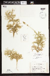 Diphasiastrum NULL 442323[1322779]Lakela, Olga 137731951-09-13 United States, Minnesota, Saint Louis, near Vermilion River gorge, St. Louis Co. (Crane Lake);Kabetogama State Forest;;;, 47.891581 -92.366824 |
MIN:Plants | 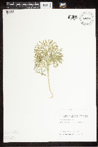 Diphasiastrum NULL 830107[1322778]Wennerstrand, R. 301992-07-25 United States, Minnesota, Roseau, Roseau County...SW1/4 NW1/4 Sec 19 T161N R36W;Beltrami Island State Forest;161N;36W;19, 48.749096 -95.341422 |
MIN:Plants | 297723[]Mexia, Ynes 21921928-08-04 United States, Alaska, McKinley National Park. Near center of N. Boundary of Park. Ridge W. of Wonder Lake. [Denali National Park], 63.45884 -150.86412, 800m |
MIN:Plants | 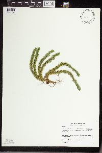 Huperzia NULL 477747[1338728]Gerdes, Lynden 41722000-07-31 United States, Minnesota, Lake, T57N R07W S13SENE. Lake County ... Little Marais, MN. Section 13 Cliff feature approx 1 mile NNE of the Finland Cemetary;North Shore;057N;07W;13, 47.410745 -91.110162 |
MIN:Plants |  Huperzia NULL 436011[1338729]Dahle, R.M. 200182000-08-16 United States, Minnesota, Itasca, Itasca County...Near the west edge of a taconite tailings pond southeast of the town of Taconite...T 56 R 24 SE1/4 of SE1/4 of Sec 27. 056N 24W 27, 47.2980003 -93.3653336 |
MIN:Plants |  Huperzia NULL 477311[1338730]Gerdes, Lynden 41082000-07-19 United States, Minnesota, Lake, North Shore / Tettegouche State Park. T56N R08W S24SWSW. Lake County ... Tettegouche State Park, northwest of Silver Bay, MN. Long, north-facing (east-west trending) cliff feature approx. 0.31 mile north of Bean Lake.. 056N 08W 24, 47.33958 -91.198054 |
MIN:Plants |  Huperzia NULL 455098[1338727]Gerdes, Lynden 4015b2000-07-06 United States, Minnesota, Lake, North Shore. T57N R07W S24SWNE. Lake County ... Little Marais, MN. Small northeast-facing cliff feature approx. 1/8 mile SE of the Superior Hiking Trail and County 6 junction. Approx. 1/4 mile SE of the Finland Cemetary.. 057N 07W 24, 47.410745 -91.110162 |
MIN:Plants |  965217[1375884]Lee, Michael MDL51002009-08-29 United States, Minnesota, Cook, Boundary Waters Canoe Area Wilderness, On a small island in Winchell Lake, in the bay leading to the Omega Lake portage, 22 miles northwest of Grand Marais. T64N R2W E1/2 of NE1/4 of SW1/4 Sec. 30, 47.99551086 -90.62878644 |
MIN:Plants |  956343[1296213]Lawrence, D.B. s.n.1949-08-12 United States, Alaska, Glacier Bay National Monument. Station 49-3. [Glacier Bay National Park], 58.797428 -136.838127 |
MIN:Plants |  509000[1307794]Zardini, E 350331993-02-10 Paraguay, National Park Ybycu'i. NE area of park. 1 km S of Arroyo Corrientes. |
MIN:Plants |  453116[1307795]Vasquez, R. 167341991-06-16 Peru, Maynas |
MIN:Plants |  480983[1341248]Cynthia A. Aulbach-Smith 1980-08-22 United States, South Carolina, Beaufort, 1/3 mi SW of the junction with US 278 near Santee Cooper Bluffton power station, 32.24389 -80.847952 |
MIN:Plants |  597868[1341249]O. Wilson Harbin 1962-06-00 United States, North Carolina, Brunswick, Brunswick Co. E side of highway 211. 7 mi from X section of 13-43, 34.069991 -78.290157 |
MIN:Plants |  528568[1341250]Garton, C.E. 1951-07-19 Canada, Ontario, Thunder Bay District. N side of Roundtable Lake, Harwick Township, 48.214368 -90.156385 |
MIN:Plants |  336852[1341251]Faith Curtis 1928-07-00 United States, Oregon, Neskowin, near Roosevelt Highway, 45.106772 -123.984282, 30m |
MIN:Plants |  608910[1341796]Kaul, Robert B. 18681961-11-26 Singapore, MacRitchie Reservoir |
MIN:Plants |  270440[1341797]Leland, B. 178B1909-12-00 New Zealand, Auckland, Kauri Gully, -35.633333 174.3 |
MIN:Plants |  270441[1341798]Leland, B. 178B1909-12-00 New Zealand, Auckland, Kauri Gully, -35.633333 174.3 |
MIN:Plants |  270681[1341799]Leland, B. 271B1910-02-00 New Zealand, Te Aroha, -37.55 175.716667 |
MIN:Plants |  270680[1341800]Leland, B. 271B1910-02-00 New Zealand, Te Aroha, -37.55 175.716667 |
MIN:Plants |  55004[1341801] Australia, Southford, -31.390572 135.771274 |
MIN:Plants | Huperzia porophila (F.E. Lloyd & L. Underwood) Holub 508811[1295018]Gerdes, Lynden B. United States, Minnesota, Lake, Detailed locality information protected. This is typically done to protect rare or threatened species localities. |
MIN:Plants | Huperzia porophila (F.E. Lloyd & L. Underwood) Holub 505440[1295020]Lee, Michael D. United States, Minnesota, Lake, Detailed locality information protected. This is typically done to protect rare or threatened species localities. |
MIN:Plants | Huperzia porophila (F.E. Lloyd & L. Underwood) Holub 379029[1294814]Lakela, Olga United States, Minnesota, Lake, Detailed locality information protected. This is typically done to protect rare or threatened species localities. |
MIN:Plants | Huperzia porophila (F.E. Lloyd & L. Underwood) Holub 55302[1294811]Rosendahl, C.O. United States, Minnesota, Hennepin, Detailed locality information protected. This is typically done to protect rare or threatened species localities. |
MIN:Plants | Huperzia porophila (F.E. Lloyd & L. Underwood) Holub 661299[1294812]Leiberg, John United States, Minnesota, Blue Earth, Detailed locality information protected. This is typically done to protect rare or threatened species localities. |
MIN:Plants | Huperzia porophila (F.E. Lloyd & L. Underwood) Holub 728211[1295017]Peck, J.H. United States, Minnesota, Winona, Detailed locality information protected. This is typically done to protect rare or threatened species localities. |
MIN:Plants | Huperzia porophila (F.E. Lloyd & L. Underwood) Holub 728212[1295016]Peck, J.H. United States, Minnesota, Houston, Detailed locality information protected. This is typically done to protect rare or threatened species localities. |
MIN:Plants | Huperzia porophila (F.E. Lloyd & L. Underwood) Holub 438066[1294813]Lee, Michael D. United States, Minnesota, Lake, Detailed locality information protected. This is typically done to protect rare or threatened species localities. |
MIN:Plants | Huperzia porophila (F.E. Lloyd & L. Underwood) Holub 68095[1295015]Gerdes, Lynden B. United States, Minnesota, Lake, Detailed locality information protected. This is typically done to protect rare or threatened species localities. |
MIN:Plants | Huperzia porophila (F.E. Lloyd & L. Underwood) Holub 948547[1294815]Lee, Jeffrey G. United States, Minnesota, Cook, Detailed locality information protected. This is typically done to protect rare or threatened species localities. |
MIN:Plants | Huperzia porophila (F.E. Lloyd & L. Underwood) Holub 376897[1294820]Dunlop, D.W. United States, Wisconsin, Sauk, Detailed locality information protected. This is typically done to protect rare or threatened species localities. |
MIN:Plants | Huperzia porophila (F.E. Lloyd & L. Underwood) Holub 594675[1294819]Cutler, H.C. United States, Missouri, Saint Francois, Detailed locality information protected. This is typically done to protect rare or threatened species localities. |
MIN:Plants | Huperzia porophila (F.E. Lloyd & L. Underwood) Holub 530968[1294818]Rood, Almon N. United States, Ohio, Portage, Detailed locality information protected. This is typically done to protect rare or threatened species localities. |
MIN:Plants | Huperzia porophila (F.E. Lloyd & L. Underwood) Holub 401217[1294817]Wood, R. United States, Ohio, Hocking, Detailed locality information protected. This is typically done to protect rare or threatened species localities. |
MIN:Plants | Huperzia porophila (F.E. Lloyd & L. Underwood) Holub 55264[1294816]Ashcraft, G.B. United States, Ohio, Cuyahoga, Detailed locality information protected. This is typically done to protect rare or threatened species localities. |
MIN:Plants | Huperzia porophila (F.E. Lloyd & L. Underwood) Holub 489092[1295019]Gerdes, Lynden B. United States, Minnesota, Lake, Detailed locality information protected. This is typically done to protect rare or threatened species localities. |
MIN:Plants | Huperzia porophila (F.E. Lloyd & L. Underwood) Holub 959026[1305253]Gerdes, Lynden B. United States, Minnesota, Lake, Detailed locality information protected. This is typically done to protect rare or threatened species localities. |
MIN:Plants | Huperzia porophila (F.E. Lloyd & L. Underwood) Holub 959029[1305256]Gerdes, Lynden B. United States, Minnesota, Lake, Detailed locality information protected. This is typically done to protect rare or threatened species localities. |
MIN:Plants | Huperzia porophila (F.E. Lloyd & L. Underwood) Holub 959028[1305255]Gerdes, Lynden B. United States, Minnesota, Lake, Detailed locality information protected. This is typically done to protect rare or threatened species localities. |
MIN:Plants | Huperzia porophila (F.E. Lloyd & L. Underwood) Holub 959027[1305254]Gerdes, Lynden B. United States, Minnesota, Lake, Detailed locality information protected. This is typically done to protect rare or threatened species localities. |
MIN:Plants | Huperzia porophila (F.E. Lloyd & L. Underwood) Holub 959061[1305288]Gerdes, Lynden B. United States, Minnesota, Cook, Detailed locality information protected. This is typically done to protect rare or threatened species localities. |
MIN:Plants | Huperzia porophila (F.E. Lloyd & L. Underwood) Holub 959025[1305252]Gerdes, Lynden B. United States, Minnesota, Cook, Detailed locality information protected. This is typically done to protect rare or threatened species localities. |
MIN:Plants | Huperzia porophila (F.E. Lloyd & L. Underwood) Holub 960599[1329200]Lee, Michael United States, Minnesota, Lake, Detailed locality information protected. This is typically done to protect rare or threatened species localities. |
MIN:Plants | Huperzia porophila (F.E. Lloyd & L. Underwood) Holub 965225[1375892]Lee, Michael United States, Minnesota, Cook, Detailed locality information protected. This is typically done to protect rare or threatened species localities. |
MIN:Plants | Huperzia porophila (F.E. Lloyd & L. Underwood) Holub 965256[1375925]Lee, Michael United States, Minnesota, Cook, Detailed locality information protected. This is typically done to protect rare or threatened species localities. |
MIN:Plants | Huperzia porophila (F.E. Lloyd & L. Underwood) Holub 965257[1375926]Lee, Michael United States, Minnesota, Cook, Detailed locality information protected. This is typically done to protect rare or threatened species localities. |
MIN:Plants | Huperzia porophila (F.E. Lloyd & L. Underwood) Holub 976250[1373803]Smith, Welby R United States, Minnesota, Lake, Detailed locality information protected. This is typically done to protect rare or threatened species localities. |
MIN:Plants |  Huperzia x buttersii (Abbe) Kartesz & Gandhi 455101[1295102]Gerdes, Lynden B. 47072000-07-19 United States, Minnesota, Lake, T56N R08W S24SWSW. Tettegouche State Park, nortwest of Silver Bay. Cliff feature approximately 0.31 mile north of Bean Lake., 47.33958 -91.198054 |
MIN:Plants |  Huperzia x buttersii (Abbe) Kartesz & Gandhi 493573[1295099]Gerdes, Lynden B. 43902001-07-12 United States, Minnesota, Lake, T57N R08W S34SESW. Finland State Forest, vicinity of Silver Bay. Approximately 6.4 miles NW of town and 2.4 miles NW of Lax Lake., 47.411133 -91.26646 |
MIN:Plants |  Huperzia x buttersii (Abbe) Kartesz & Gandhi 438644[1295094]Lee, Michael D. MDL2926A2001-06-07 United States, Minnesota, Lake, Superior National Forest. Along County Road 7 and Nine Mile Creek, 2 1/4 miles north of Cramer. T59N R6W NW1/4 of NW1/4 of NW1/4 Sec. 34, NE1/4 of NE1/4 of NE1/4 Sec.33, 47.551557 -91.075831 |
MIN:Plants |  Huperzia x buttersii (Abbe) Kartesz & Gandhi 508920[1294993]Lee, Michael D. MDL27802000-07-11 United States, Minnesota, Lake, Superior National Forest. Along Hockamin Creek four miles southwest of Finland. T57N R8W SW1/4 of NW1/4 Sec. 26, SE1/4 of NE1/4 Sec. 27, 47.410504 -91.26732 |
MIN:Plants | Huperzia porophila (F.E. Lloyd & L. Underwood) Holub 964655[1375608]Lee, Michael United States, Minnesota, Cook, Detailed locality information protected. This is typically done to protect rare or threatened species localities. |
MIN:Plants | Huperzia porophila (F.E. Lloyd & L. Underwood) Holub 965325[1375994]Lee, Michael United States, Minnesota, Cook, Detailed locality information protected. This is typically done to protect rare or threatened species localities. |
MIN:Plants | Huperzia porophila (F.E. Lloyd & L. Underwood) Holub 965341[1356202]Lee, Michael United States, Minnesota, Cook, Detailed locality information protected. This is typically done to protect rare or threatened species localities. |
MIN:Plants |  Huperzia x buttersii (Abbe) Kartesz & Gandhi 477724[1294996]Gerdes, Lynden B. 41922000-08-02 United States, Minnesota, Lake, T56N R08W S13SWSE. Tettegouche State Park. Cliff feature approx. 2.25 miles NNW of Silver Bay, MN and 1 mile south of Lax Lake., 47.33958 -91.198054 |
MIN:Plants |  Huperzia x buttersii (Abbe) Kartesz & Gandhi 508822[1294992]Gerdes, Lynden B. 41902000-08-02 United States, Minnesota, Lake, T56N R08W S24NENW. Tettegouche State Park. Cliff feature approx. 2.25 miles NNW of Silver Bay, MN, and 1 mile south of Lax Lake., 47.33958 -91.198054 |
MIN:Plants |  Huperzia x buttersii (Abbe) Kartesz & Gandhi 478098[1294994]Gerdes, Lynden B. 41912000-08-02 United States, Minnesota, Lake, T56N R08W S13SWSE. Tettegouche State Park. Cliff feature approx. 2.25 miles NNW of Silver Bay, MN, and 1 mile south of Lax Lake., 47.33958 -91.198054 |
MIN:Plants |  Huperzia x buttersii (Abbe) Kartesz & Gandhi 477244[1294990]Gerdes, Lynden B. 41122000-07-19 United States, Minnesota, Lake, T56N R08W S24SESW. Tettegouche State Park, northwest of Silver Bay, MN. Long, north-facing (east-west trending) cliff feature 0.25-0.50 mile north of Bear and Bean Lakes., 47.33958 -91.198054 |
MIN:Plants |  Huperzia x buttersii (Abbe) Kartesz & Gandhi 510062[1294991]Gerdes, Lynden B. 41472000-07-25 United States, Minnesota, Lake, T57N R07W S35SWSW. Wolf Ridge Environmental Learning Center, Finland, MN. Cliff feature on the south side of Wolf Lake., 47.379057 -91.182368 |
MIN:Plants |  Huperzia x buttersii (Abbe) Kartesz & Gandhi 915909[1295117]Smith, Welby R. 314272009-08-29 United States, Minnesota, Cook, Boundary Waters Canoe Area Wilderness, Superior National Forest. On the north side of Winchell Lake. T 64N R 2W NW1/4 of SE1/4 of Sec 30, 47.994167 -90.624722 |
MIN:Plants |  Huperzia x buttersii (Abbe) Kartesz & Gandhi 774437[1295116]Monson, Paul H. 54751983-06-20 United States, Minnesota, Saint Louis, Voyageur's National Park. R-20W, T-68N, S-9. Ash River Trail, ca. 6 mi east of Hwy. 53; south side of road, 48.41713 -92.789044 |
MIN:Plants |  Huperzia x buttersii (Abbe) Kartesz & Gandhi 357223[1295107]Butters, F.K. 291938-07-07 United States, Minnesota, Cook, At W end of Mountain Lake. T65N;R1E [Boundary Waters Canoe Area Wilderness / Superior National Forest], 48.10737 -90.224172 |
MIN:Plants |  Huperzia x buttersii (Abbe) Kartesz & Gandhi 357224[1295105]Butters, F.K. 2461937-07-04 United States, Minnesota, Cook, South side of Mountain Lake E of portage to Clearwater Lake. T65N R2E [Boundary Waters Canoe Area Wilderness / Superior National Forest], 48.10737 -90.224172 |
MIN:Plants |  Huperzia x buttersii (Abbe) Kartesz & Gandhi 357392[1295110]Rosendahl, C.O. 68811937-08-27 United States, Minnesota, Lake, About half way on the Ely - Finland Road [Superior National Forest], 47.414636 -91.249048 |
MIN:Plants |  Huperzia x buttersii (Abbe) Kartesz & Gandhi 357396[1295112]Butters, F.K. 961938-07-11 United States, Minnesota, Cook, South of the outlet of Rove Lake. Twp.65N R1E [Boundary Waters Canoe Area Wilderness / Superior National Forest], 48.092221 -90.37664 |
MIN:Plants |  Huperzia x buttersii (Abbe) Kartesz & Gandhi 369335[1295108]Lakela, Olga 48891941-10-25 United States, Minnesota, Lake, Gooseberry River, at the Upper Falls [Gooseberry Falls State Park; T54N;R9W;S22], 47.146872 -91.463229 |
MIN:Plants |  Huperzia x buttersii (Abbe) Kartesz & Gandhi 385578[1295109]Lakela, Olga 57761944-08-14 United States, Minnesota, Lake, Pancake Island in Lake Superior, between East Beaver Bay and the Palisades [T55N;R7W], 47.2677 -91.282943 |
MIN:Plants |  Huperzia x buttersii (Abbe) Kartesz & Gandhi 386003[1295111]Lakela, Olga 56811944-08-10 United States, Minnesota, Lake, At Baptism River [assuming along highway 61: Tettegouche State Park], 47.337555 -91.200419 |
MIN:Plants |  Huperzia x buttersii (Abbe) Kartesz & Gandhi 387764[1295113]Schuster, R.M. 60051947-09-05 United States, Minnesota, Cook, In center of Pigeon Point, beyond Clarks Bay. [Grand Portage Indian Reservation], 47.997942 -89.538143 |
MIN:Plants |  Huperzia x buttersii (Abbe) Kartesz & Gandhi 393244[1295106]Ownbey, Gerald B. 10571948-08-14 United States, Minnesota, Cook, E tip of Porcupine Island, Susie Islands near Grand Portage [Susie Islands, The Nature Conservancy Preserve; T64N;R7E], 47.973776 -89.578978 |
MIN:Plants |  Huperzia x buttersii (Abbe) Kartesz & Gandhi 443234[1295115]Lakela, Olga 138821951-09-16 United States, Minnesota, Saint Louis, Sandbar Island in St. Louis River Bay, Duluth Harbor, Duluth, 46.7833 -92.1 |
MIN:Plants |  Huperzia x buttersii (Abbe) Kartesz & Gandhi 661297[1295101]Butters, F.K. 246A1937-07-04 United States, Minnesota, Cook, on south side of Mountain Lake, east of portage to Clearwater Lake. Twp. 65N R. 1E [Boundary Waters Canoe Area Wilderness / Superior National Forest], 48.10737 -90.224172 |
MIN:Plants |  Huperzia x buttersii (Abbe) Kartesz & Gandhi 661301[1295114]Rosendahl, C.O. 68811937-08-27 United States, Minnesota, Lake, About half way on Ely - Finland Road [Superior National Forest], 47.414636 -91.249048 |
MIN:Plants |  Huperzia x buttersii (Abbe) Kartesz & Gandhi 684844[1338823]Meyer, Rob 201977-08-06 United States, Minnesota, Cook, Cook Co.; North side of Pigeon Point; NE1/4 sec.28 T 64N R 7E;Grand Portage Indian Reservation / North Shore;064N;07E;28, 47.997942 -89.538143 |
MIN:Plants |  Huperzia x buttersii (Abbe) Kartesz & Gandhi 688434[1295103]Meyer, Robert Jon 541977-08-08 United States, Minnesota, Cook, Beginning of Kekekabic Trail (Fernberg Road). Superior National Forest. 2.5 mi S of Seagull Lake Ranger Station Cook Co. Beginning of Kekekabic Trail (Fernberg Rd.). Superior National Forest. 2.5 mi S of Seagull Lake Ranger Station on Gunflint Trail; SW1/4 NE1/4 sec.27 T65N R4W, 48.084242 -90.825443 |
MIN:Plants |  Huperzia x buttersii (Abbe) Kartesz & Gandhi 722748[1295104]Trana, Thomas D. 2518D1977-08-08 United States, Minnesota, Cook, Superior National Forest. 2 1/2 mi SE of Sea Gull Lake Ranger Station (40 mi N of Tofte) [Boundary Waters Canoe Area Wilderness], 48.094771 -90.885475 |
MIN:Plants | Huperzia x buttersii (Abbe) Kartesz & Gandhi 661302[]Butters, F.; et al. 111a1938-07-11 United States, Minnesota, Cook, Cliff south of Rove Lake;Boundary Waters Canoe Area Wilderness / Superior National Forest;065N;01E;, 48.092221 -90.37664 |
MIN:Plants |  Huperzia x buttersii (Abbe) Kartesz & Gandhi 229272[1295118]Cooper, William 3951909-08-24 United States, Michigan, Keweenaw, Passage Id. Isle Royale;Isle Royale National Park |
MIN:Plants |  Huperzia x buttersii (Abbe) Kartesz & Gandhi 477749[1295096]Gerdes, Lynden B. 40342000-07-12 United States, Minnesota, Lake, T57N R06W S19NWSW. Little Marais. Small, isolated, northwet-facing cliff feature approx. 1/2 mile ESE of the Superior Hiking Trail and County 6 junction. Approx. 0.75 mile ESE of the Finland Cemetary, 47.410745 -91.110162 |
MIN:Plants |  Huperzia x buttersii (Abbe) Kartesz & Gandhi 477756[1295100]Gerdes, Lynden B. 40482000-07-13 United States, Minnesota, Lake, T57N R08W S26SWNW. Wolf Ridge Environmental Learning Center, Finland, MN. Cliff feature on the south side of Hockamin Creek., 47.410504 -91.26732 |
MIN:Plants |  Huperzia x buttersii (Abbe) Kartesz & Gandhi 493825[1295093]Gerdes, Lynden B. 44332001-08-02 United States, Minnesota, Lake, T56N R07W S17SWNE. Tettegouche State Park, Mount Trudee. Approximately 2.6 miles north of Silver Bay, 47.33958 -91.198054 |
MIN:Plants |  Huperzia x buttersii (Abbe) Kartesz & Gandhi 480565[1294989]Gerdes, Lynden B. 41042000-07-19 United States, Minnesota, Lake, T56N R08W S24SWSW. Tettegouche State Park, northwest of Silver Bay, MN. Long, north-facing (east-west trending) cliff feature approx. 0.31 mile north of Bean Lake., 47.33958 -91.198054 |
MIN:Plants |  Huperzia x buttersii (Abbe) Kartesz & Gandhi 477764[1294995]Gerdes, Lynden B. 41142000-07-19 United States, Minnesota, Lake, T56N R08W S24SESW. Tettegouche State Park, northwest of Silver Bay, MN. Cliff feature approximately 0.25 mile NW of Bear Lake., 47.33958 -91.198054 |
MIN:Plants |  Huperzia x buttersii (Abbe) Kartesz & Gandhi 477752[1295098]Gerdes, Lynden B. 41372000-07-25 United States, Minnesota, Lake, T57N R07W S34NESE. Wolf Ridge Environmental Learning Center, Finland, MN. Southwest portion of the Wolf Lake cliff feature., 47.378962 -91.203696 |
MIN:Plants |  Huperzia x buttersii (Abbe) Kartesz & Gandhi 477745[1295095]Gerdes, Lynden B. 4106A2000-07-19 United States, Minnesota, Lake, T56N R08W S24SWSW. Tettegouche State Park, nortwest of Silver Bay. Cliff feature approximately 0.31 mile north of Bean Lake, 47.33958 -91.198054 |
MIN:Plants |  Huperzia x buttersii (Abbe) Kartesz & Gandhi 480588[1295097]Gerdes, Lynden B. 41412000-07-25 United States, Minnesota, Lake, T57N R07W S34NESE. Wolf Ridge Environmental Learning Center, Finland, MN. Southwest portion of the Wolf Lake cliff feature., 47.378962 -91.203696 |
MIN:Plants |  Huperzia x buttersii (Abbe) Kartesz & Gandhi 498956[1294998]Lee, Michael D. MDL30692001-07-26 United States, Minnesota, Cook, Superior National Forest. Above the Onion River 3 1/2 miles northeast of Tofte. Atop Leveaux Mountain. T59N R4W S1/2 of SE1/4 Sec.2, 47.620737 -90.778342 |
MIN:Plants |  Huperzia x buttersii (Abbe) Kartesz & Gandhi 946484[1289936]Gerdes, Lynden B. 47472003-07-09 United States, Minnesota, Lake, Superior National Forest. Approximately 7.36 miles ENE of Isabella, MN and 0.06 mile W of Scott Lake. NWSE of section; T060N R07W sec34, 47.638176 -91.203147 |
MIN:Plants |  Huperzia x buttersii (Abbe) Kartesz & Gandhi 383340[1295119]Butters, F.K. s.n. Canada, Ontario |
MIN:Plants |  Huperzia x buttersii (Abbe) Kartesz & Gandhi 489101[1294997]Gerdes, Lynden B. 44892001-09-06 United States, Minnesota, Lake, Tettegoche State Park, Silver Bay, MN. Northwest-facing cliff approximately 0.44 mile east of Nipisquit Lake. T56N R07W S09NENW, 47.350603 -91.229562 |
MIN:Plants |  Huperzia x buttersii (Abbe) Kartesz & Gandhi 959030[1305257]Gerdes, Lynden B. 44892001-09-06 United States, Minnesota, Lake, Tettegoche State Park, Silver Bay, MN. Northwest-facing cliff approximately 0.44 mile east of Nipisquit Lake., 47.350603 -91.229562 |
MIN:Plants |  Huperzia x buttersii (Abbe) Kartesz & Gandhi 959054[1305281]Gerdes, Lynden B. 57032008-09-15 United States, Minnesota, Saint Louis, Superior National Forest. Approximately 5.77 miles NNW of Ely, MN and 0.39 miles N of High Lake. Accessed south off of FR 460., 47.98527778 -91.86361111 |
MIN:Plants |  Huperzia x buttersii (Abbe) Kartesz & Gandhi 959056[1305283]Gerdes, Lynden B. 57052008-09-15 United States, Minnesota, Saint Louis, Superior National Forest. Approximately 5.77 miles NNW of Ely, MN and 0.39 miles N of High Lake. Accessed south off of FR 460., 47.98527778 -91.86361111 |
MIN:Plants |  Huperzia x buttersii (Abbe) Kartesz & Gandhi 959048[1305275]Gerdes, Lynden B. 57062008-09-15 United States, Minnesota, Saint Louis, Superior National Forest. Approximately 5.77 miles NNW of Ely, MN and 0.39 miles N of High Lake. Accessed south off of FR 460., 47.98527778 -91.86361111 |
MIN:Plants |  Huperzia x buttersii (Abbe) Kartesz & Gandhi 959051[1305278]Gerdes, Lynden B. 57192009-06-03 United States, Minnesota, Cook, Superior National Forest. South Fowl Cliff., 48.04305556 -90.00666667 |
MIN:Plants |  Huperzia x buttersii (Abbe) Kartesz & Gandhi 959062[1305289]Gerdes, Lynden B. 59582009-07-14 United States, Minnesota, Cook, Superior National Forest. Pigeon River Purchase Unit. Approximately 0.37 miles southwest of the Pigeon River and Swamp River confluence., 47.99972222 -89.93472222 |
MIN:Plants |  Huperzia x buttersii (Abbe) Kartesz & Gandhi 959013[1305240]Gerdes, Lynden B. 60222010-06-16 United States, Minnesota, Cook, Superior National Forest. Approximately 0.74 miles southeast of McFarland Lake and 0.30 miles northeast of Cty. Rd.16., 48.03805556 -90.04555556 |
MIN:Plants |  Huperzia x buttersii (Abbe) Kartesz & Gandhi 959018[1305245]Gerdes, Lynden B. 64312011-09-07 United States, Minnesota, Lake, Superior National Forest. Approximately 16.81 miles NW of Isabella, MN and 0.68 miles west of Norway Lake., 47.79222222 -91.60194444 |
MIN:Plants |  Huperzia x buttersii (Abbe) Kartesz & Gandhi 958997[1305224]Gerdes, Lynden B. 69142013-08-15 United States, Minnesota, Saint Louis, Superior National Forest. BWCAW. Approximately 13.40 miles ENE of Crane Lake, MN and 0.07 miles north of Little Beartrack Lake., 48.31027778 -92.20694444 |
Google Map
Google Maps is a web mapping service provided by Google that features a map that users can pan (by dragging the mouse) and zoom (by using the mouse wheel). Collection points are displayed as colored markers that when clicked on, displays the full information for that collection. When multiple species are queried (separated by semi-colons), different colored markers denote each individual species.