University of Minnesota
http://www.umn.edu/
612-625-5000
http://www.umn.edu/
612-625-5000
Minnesota Biodiversity Atlas
Bell Museum
Dataset: MIN-Plants
Taxa: Mysinaceae
Search Criteria: excluding cultivated/captive occurrences
1
Page 1, records 1-3 of 3
Bell Museum plants | |
 MIN:Plants | 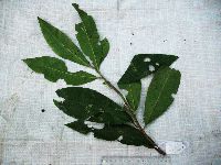 Ardisia imperialis K.Schum. 921350[]Whitfeld, T.J.S. PA4A02212008-08-14 Papua New Guinea, Madang, Wanang Village, -5.237483 145.115733, 129m |
MIN:Plants | 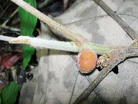 Ardisia Sw. 903140[] GW27432006-10-18 Papua New Guinea, East Sepik, Wamangu, -3.533333 143.666667, 90m |
MIN:Plants | 489429[]B. Isua GW12322001-02-06 Papua New Guinea, Madang, Ohu Conservation Area, 5.216667 -145.683333, 100m |
1
Page 1, records 1-3 of 3
Google Map
Google Maps is a web mapping service provided by Google that features a map that users can pan (by dragging the mouse) and zoom (by using the mouse wheel). Collection points are displayed as colored markers that when clicked on, displays the full information for that collection. When multiple species are queried (separated by semi-colons), different colored markers denote each individual species.