University of Minnesota
http://www.umn.edu/
612-625-5000
http://www.umn.edu/
612-625-5000
Minnesota Biodiversity Atlas
Bell Museum
Dataset: MIN-Plants
Taxa: Oleaceae
Search Criteria: excluding cultivated/captive occurrences
Bell Museum plants | |
 MIN:Plants |  171717[1302538]Wood, J. M. 49571892-12-08 South Africa, Buffalo river near Charlestown, 5000 - 6000m |
MIN:Plants |  974159[1396530]P. S. Green 13021963-10-12 New Caledonia, South slope of Tiendana, near Oundjo, about 15 km west of Kone |
MIN:Plants | Fraxinus caroliniana Miller 477472[]US Nat. Arboretum staff 1491978-00-00 United States, Virginia, Surry, Surry Co. |
MIN:Plants | Fraxinus dipetala Hooker & Arnott 509954[]Univ. of Calif. Bot. Gard. list 17 - 461974-00-00 United States, California, Colusa, Colusa Co. |
MIN:Plants |  488904[1033596]Smith, Welby 155051989-06-30 United States, Minnesota, Chisago, Chisago County ... Interstate State Park in Taylors Falls, in the St. Croix Valley ... SW1/4 SE1/4 section 25, T34N R19W;Interstate State Park;034N;19W;25, 45.40474 -92.66223 |
MIN:Plants | 511376[]US Nat. Arboretum staff 1291975-00-00 United States, District of Columbia, Washington |
MIN:Plants |  367981[1033616]Morley, T. 11101966-07-20 United States, Minnesota, Houston, Houston County...4.6 mi. S of S edge of Brownsville; T 102N, R 4W, Sec. 24.;Dorer Memorial Hardwood State Forest;102N;04W;24, 43.62315 -91.27054 |
MIN:Plants |  506832[1033613]Smith, Welby 129421987-06-11 United States, Minnesota, Fillmore, Root River Valley, about 3 mi SW of Peterson. SW1/4 SE1/4 of section;Dorer Memorial Hardwood State Forest;104N;09W;35, 43.76755 -91.88003 |
MIN:Plants |  601248[1033599]Morley, T. 11101966-07-20 United States, Minnesota, Houston, Houston Co. 4.6 mi. S of S edge of Brownsville; T102N, R4W, Sec. 24.;Dorer Memorial Hardwood State Forest;102N;04W;24, 43.62315 -91.27054 |
MIN:Plants |  601249[1033615]Morley, T. 11111966-07-20 United States, Minnesota, Winona, Winona Co. Above hwy, 2.2 mi. S of S edge of Dakota; T105N, R4W, SE1/4 Sec. 20.;;105N;04W;20, 43.88323 -91.33121 |
MIN:Plants |  601250[1033602]Morley, T. 11121966-09-25 United States, Minnesota, Fillmore, Fillmore Co. S edge of Preston, near hilltop S of the Root River, E side of co. rd. 17. T102N, R10W, S1/4 Sec. 6 near i Fillmore Co. S edge of Preston, near hilltop S of the Root River, E side of co. rd. 17. T102N, R10W, S1/4 Sec. 6 near its center.. 102N 10W , 43.66665 -92.07947 |
MIN:Plants |  601251[1033624]Morley, T. 11131966-09-25 United States, Minnesota, Fillmore, Ca. 3 mi WNW of Wykoff. NE1/4 NE1/4 of section;;103N;13W;24, 43.7106 -92.33914 |
MIN:Plants |  601256[1033630]Morley, T. 11151966-09-25 United States, Minnesota, Olmsted, Dorer Memorial Hardwood State Forest. Olmsted Co. About 1 mi W of Cummingsville; T105N, R12W, W1/2 Sec. 28, SE side of road, ca. 3/4 of the way up the hill f Olmsted Co. About 1 mi W of Cummingsville; T105N, R12W, W1/2 Sec. 28, SE side of road, ca. 3/4 of the way up the hill from the valley.. 105N 12W 28, 43.86938 -92.26855 |
MIN:Plants |  601258[1033626]Morley, T. 11161966-09-25 United States, Minnesota, Goodhue, 5 mi. S of S edge of Cannon Falls on road to Rochester, 200 yds. E of hwy. T111N, R17W, SE1/4 Sec. 8 (Leon Twp.);;111N;17W;8, 44.43501 -92.88094 |
MIN:Plants |  602335[1033612]Johnson, Albert s.n.1966-08-04 United States, Minnesota, Pine, Pine Co. Along Hwy. 48, SE1/4 SE1/4 Sec. 23, Ogema Twp. T41N, R17W.;;041N;17W;23, 46.01981 -92.45705 |
MIN:Plants |  602342[1033595]Johnson, Albert s.n.1966-07-31 United States, Minnesota, Chisago, 2 mi. N of Taylors Falls on Hwy. 71.;;;;, 45.4309 -92.65222 |
MIN:Plants |  602343[1033600]Johnson, Albert s.n.1966-07-31 United States, Minnesota, Chisago, Along Hwy 16, Shafer Twp, T34N, R19W, SE1/2 Sec. 13.;;034N;19W;13, 45.43371 -92.66217 |
MIN:Plants |  602344[1033619]Johnson, Albert s.n.1966-08-24 United States, Minnesota, Pine, Pine Co. 3 mi W of the St. Croix River, Hwy. 70, T41N, Sec. 16, Rock Creek Twp.;Saint Croix State Forest;041N;17W;16, 46.03384 -92.49857 |
MIN:Plants |  603793[1033604]Moore, John; et al. 269651966-07-30 United States, Minnesota, Houston, Houston County...Bluffs of the Mississippi River, 2 mi. N of Reno;;102N;04W;, 43.63008 -91.275 |
MIN:Plants |  603833[1033608]Moore, John; et al. 272311967-09-20 United States, Minnesota, Olmsted, Olmsted County...Bluffs of the White Water River, Sec. 2, Quincy Twp.;;107N;11W;, 44.06444 -92.14639 |
MIN:Plants |  603973[1033605]Moore, John; et al. 269661966-07-30 United States, Minnesota, Houston, Houston County...Bluffs of the Mississippi River along the River Road, 2 mi. N of Reno;Dorer Memorial Hardwood State Forest;102N;04W;, 43.63008 -91.275 |
MIN:Plants |  621990[1033607]Johnson, Albert s.n.1968-09-11 United States, Minnesota, Pine, Pine Co. E side of Hwy. 35. 2 1/2 mi. N of Hinckley.;;;;, 46.04035 -92.94417 |
MIN:Plants |  621991[1033629]Johnson, Albert s.n.1966-08-04 United States, Minnesota, Pine, Pine Co. SE1/4 of SE1/4 Sec. 23, T41N, R17W, Ogema Twp.;;041N;17W;23, 46.01981 -92.45705 |
MIN:Plants |  621992[1033617]Johnson, Albert s.n.1971-09-11 United States, Minnesota, Pine, Pine Co. E side of Hwy. 35. 2 1/2 mi. N of Hinckley;;;;, 46.04035 -92.94417 |
MIN:Plants |  621993[1033610]Johnson, Albert s.n.1970-09-09 United States, Minnesota, Pine, Pine Co. E side of Hwy. 35. 2 1/2 mi. N of Hinckley.;;;;, 46.04035 -92.94417 |
MIN:Plants |  621998[1033603]Johnson, Albert s.n.1966-07-03 United States, Minnesota, Chisago, 1 1/2 mi. N of Taylors Falls on Hwy. 16;;;;, 45.4309 -92.65222 |
MIN:Plants |  622002[1033606]Johnson, Albert s.n.1966-07-31 United States, Minnesota, Chisago, Along Hwy. 71, 2 mi. N of Taylors Falls;;;;, 45.4309 -92.65222 |
MIN:Plants |  622007[1033618]Johnson, Albert s.n.1971-10-01 United States, Minnesota, Kanabec, Kanabec Co. 3 mi SW of Ogilvie, on the r.r. grade, N side of Hwy. 23. NW1/4 SW1/4 Sec. 5, T38N, R25W.;;038N;25W;5, 45.81353 -93.48305 |
MIN:Plants |  622008[1033601]Johnson, Albert s.n.1971-10-01 United States, Minnesota, Mille Lacs, Roadside, Co. 31, E edge of village of Isle. SW1/4 SW1/4 Sec. 1, T42N, R25W.;;042N;25W;1, 46.14689 -93.44215 |
MIN:Plants |  622009[1033609]Johnson, Albert s.n.1971-10-01 United States, Minnesota, Kanabec, Kanabec Co. 2 mi N of Ogilvie. NW1/4 NW1/4 Sec. 14, T39N, R25W;;039N;25W;14, 45.86832 -93.42163 |
MIN:Plants |  622010[1033598]Johnson, Albert s.n.1971-09-27 United States, Minnesota, Mille Lacs, E side of Hwy. 47 ca. 1/4 mi. N of the village of Isle. Lot 7. Sec. 35, T43N, R25W.;;043N;25W;35, 46.16125 -93.46237 |
MIN:Plants |  622012[1033614]Johnson, Albert s.n.1971-10-01 United States, Minnesota, Mille Lacs, On th N side of Hwy. 27, between Isle and Wahkon. NE1/4 SW1/4 of section;;042N;25W;09, 46.13274 -93.50455 |
MIN:Plants |  622013[1033623]Johnson, Albert s.n.1971-10-01 United States, Minnesota, Mille Lacs, Along Co. Rd. 41 NE of Isle. SW1/4 NW1/4 Sec. 36, T43N, R25W.;;043N;25W;36, 46.16108 -93.44153 |
MIN:Plants |  622014[1033625]Johnson, Albert s.n.1971-10-01 United States, Minnesota, Mille Lacs, Mille Lacs Co. Near Indian house on W side of Hwy. 169, Mille Lacs Indian Reservation. SE1/4 SE1/4 Sec. 17, T43N, R27W.;Mille Lacs Indian Reservation;043N;27W;17, 46.20704 -93.77753 |
MIN:Plants |  622015[1033631]Johnson, Albert s.n.1971-10-01 United States, Minnesota, Mille Lacs, N side of Co. Rd. 41, NE of Isle. SW1/4 of NW1/4 Sec. 35, T43N, R25W.;;;;, 46.16125 -93.46237 |
MIN:Plants |  622018[1033622]Johnson, Albert s.n.1971-10-01 United States, Minnesota, Mille Lacs, N side of Co. Rd. 41 NE of Isle. SW1/4 NW1/4 Sec. 35, T43N, R25W.;;043N;25W;35, 46.16125 -93.46237 |
MIN:Plants |  622042[1033611]Johnson, Albert s.n.1971-09-27 United States, Minnesota, Mille Lacs, E side of hwy. N of Isle; T42N, R25W, Sec. 2;;042N;25W;2, 46.14698 -93.46296 |
MIN:Plants |  644894[1033620]Neese, E. 11321973-12-30 United States, Minnesota, Ramsey, Ramsey Co.; Beside Lake Judy, Shoreview;;030N;23W;, 45.07917 -93.14694 |
MIN:Plants |  817415[1033628]Delaney, B. 890231989-06-15 United States, Minnesota, Isanti, Cranberry Wildlife Management Area, N border Isanti Co. SW1/4 SW1/4 Sec. 4, T37N, R24W.;;037N;24W;4, 45.72368 -93.33798 |
MIN:Plants |  831461[1033627]Cloutier, H. s.n.1943-07-20 United States, Minnesota, Itasca, Itasca Co, Coleraine, Trout Lake vicinity;;;;, 47.25722 -93.40222 |
MIN:Plants |  833532[1033597]Juhnke, C. 1431991-06-24 United States, Minnesota, Fillmore, Forestville State Park. Fillmore Co. T102N R12W Sec.20 NE NE SE; near Mystery Cave II;Forestville State Park;102N;12W;20, 43.62366 -92.2986 |
MIN:Plants |  690670[1033632]Shane, L. 77-331977-07-11 United States, Maine, Oxford, Oxford County ... summit of Mt. Sabattus, Lovell Township;;;;, 44.1824 -70.8513, 390m |
MIN:Plants | 511375[]US Nat. Arboretum staff 1281975-00-00 United States, Maine, Oxford, Oxford Co. |
MIN:Plants |  915992[1033621]Smith, Welby 250681994-08-11 United States, Minnesota, Olmsted, Olmsted County...Oxbow County Park, about 2 miles north of Byron...T 107N R 15W NW1/4 of NW1/4 of Sec. 17;Oxbow County Park;107N;15W;17, 44.0769444 -92.6538889 |
MIN:Plants | 509466[]US Nat. Arboretum staff 77-1361977-00-00 United States, Maryland, Anne Arundel, [no further data] |
MIN:Plants | 510885[]US Nat. Arboretum staff 1421976-00-00 United States, Maryland, Anne Arundel, [no further data] |
MIN:Plants |  934919[1283365]Whitfeld, T. J. S.; et al. 7712011-09-06 United States, Minnesota, Chisago, UTM: 15T0519840, 5042913;Wild River State Park;;;, 45.53947 -92.7458761 |
MIN:Plants |  601255[1283364;1283364_1]Morley, T. 11141966-09-25 United States, Minnesota, Fillmore, Ca. 3 miles WNW of Wykoff. NE1/4 NE1/4 of section.;Dorer Memorial Hardwood State Forest;103N;13W;24, 43.7106049 -92.3391389 |
MIN:Plants |  947457[1283367]Nee, M. 611812014-06-10 United States, Wisconsin, Polk, Interstate Park, St. Croix Falls; near Ice Age shop. T34N, R18W, sect. 30 [St. Croix National Riverway], 45.396389 -92.642222, 298m |
MIN:Plants |  961101[1334245]Timothy J. S. Whitfeld 17272018-06-12 United States, Rhode Island, Providence, Diamond Hill Reservation, 0.4 miles east south east of the intersection between West Wrentham Road and Pine Swamp Road., 42.0093333 -71.439 |
MIN:Plants |  964137[1375106] United States, Indiana |
MIN:Plants |  964138[1375107] United States, Wisconsin |
MIN:Plants |  964139[1375108] United States, Michigan |
MIN:Plants |  623122[1034069]Moore, John 273741971-06-04 United States, Minnesota, Isanti, Across the road W of Beckman Lake, Cedar Creek Natural History Area; Athens Twp.;Cedar Creek National History Area;034N;23W;, 45.42444 -93.18444 |
MIN:Plants |  964143[1375112] United States, Nebraska |
MIN:Plants |  Ligustrum lucidum W.T. Aiton 829138[1299081]Nelson, John B. 12063 United States, South Carolina, Richland |
MIN:Plants |  Ligustrum lucidum W.T. Aiton 677979[1299080]Richardson, Denise 24 United States, Texas, Brazos |
MIN:Plants |  Fraxinus nigra Marshall 436824[1033753]Smith, Welby 167542000-05-30 United States, Minnesota, Olmsted, Whitewater Wildlife Management Area. Olmsted County...In the Whitewater State Wildlife Management Area, about 4 miles southeast of Plainview...Whitewater River...T 107N R 11W SE1/4 of NW1/4 of Sec 3. 107N 11W 3, 44.1016667 -92.1338889 |
MIN:Plants |  Fraxinus nigra Marshall 429085[1033634]Smith, Welby 271481998-05-26 United States, Minnesota, Pine, Banning State Park. Pine County ... Banning State Park, about 2.5 mi north-northeast of Sandstone ... along the Kettle River ... T 43N R 20W SW1/4 of NE1/4 of Sec 35. 043N 20W 35, 46.1658333 -92.8327778 |
MIN:Plants |  Fraxinus nigra Marshall 474185[1033685]Moore, John 6131971-09-24 United States, Minnesota, Sherburne, SE1/4 S-14 Santiago Tshp. [ Sherburne Wildlife Refuge];Sherburne National Wildlife Refuge;035N;27W;14, 45.52313 -93.66503 |
MIN:Plants |  Fraxinus nigra Marshall 916532[1033679]Smith, Welby 223061993-06-03 United States, Minnesota, Sibley, Vale Wildlife Management Area. Sibley County ... Vale State Wildlife Management Area; in the valley of High Island Creek, about 2.5 miles southwest its confluence with the Minnesota River ... T113N R26W NE1/4 of SW1/4 of Sec 27. 113N 26W 27, 44.5625 -93.9427778 |
MIN:Plants |  Fraxinus nigra Marshall 899087[1033659]Myhre, K. 19381992-05-26 United States, Minnesota, Cass, Cass County...Located on the west side of Jack Lake...T 141N R 30W NE1/4 of SE1/4 of Sec 3;Chippewa National Forest / Leech Lake Indian Reservation;141N;30W;03, 47.05941 -94.45966 |
MIN:Plants |  Fraxinus nigra Marshall 899483[1033739]Smith, Welby 292432001-08-01 United States, Minnesota, Washington, William O'Brien State Park. Washington County...William O'Brien State Park, about 1.5 miles north of Marine on St. Croix...T32N R19W NW1/4 of NE1/4 of Sec 31. 032N 19W 31, 45.2233333 -92.7613889 |
MIN:Plants |  Fraxinus nigra Marshall 459526[1033658]Smith, Welby 273691998-07-10 United States, Minnesota, Otter Tail, Bluff Creek Wildlife Management Area. Otter Tail County...Bluff Creek State Wildlife Management Area, about 11 miles west of Sebeka...T136N R37W NE1/4 of NW1/4 of Sec 2. 136N 37W 2, 46.6286125 -95.3144455 |
MIN:Plants |  Fraxinus nigra Marshall 477286[1033655]Smith, Welby 205401992-06-24 United States, Minnesota, Brown, Boesch Wildlife Management Area. Brown County ... Boesch State Wildlife Management Area, about 3 miles northwest of New Ulm, in the Minnesota River Valley ... T 110N R 31W SW1/4 of NW1/4 of Sec 3. 110N 31W 3, 44.3624992 -94.5494461 |
MIN:Plants |  Fraxinus nigra Marshall 171560[1033640]Rosendahl, C.; et al. 44261924-05-04 United States, Minnesota, Goodhue, West of Frontenac. Goodhue County;Frontenac State Park;112N;13W;00, 44.51111 -92.35639 |
MIN:Plants |  Fraxinus nigra Marshall 171561[1283375]Oestlund, O. s.n.1888-08-00 United States, Minnesota, Hennepin, [no further data];;;;, 45 -93.47 |
MIN:Plants |  Fraxinus nigra Marshall 171562[1033726]Sheldon, Edmund S28681892-07-00 United States, Minnesota, Kanabec, Mora;;039N;24W;, 45.86068 -93.32753 |
MIN:Plants |  Fraxinus nigra Marshall 171564[1033693]Nelson, N.L.T. s.n.1893-05-00 United States, Minnesota, Goodhue, Cannon Falls;;;;, 44.50694 -92.90528 |
MIN:Plants |  Fraxinus nigra Marshall 171565[1283372]Holzinger, John s.n.1901-04-00 United States, Minnesota, Winona, Winona Co.;;N;;, 44.049963 -91.639315 |
MIN:Plants |  Fraxinus nigra Marshall 171566[1033729]Butters, F.; et al. 35321918-06-22 United States, Minnesota, Wabasha, Zumbro Valley, near Kellogg;;;;, 44.30861 -91.99556 |
MIN:Plants |  Fraxinus nigra Marshall 171567[1033741]Arthur, J.; et al. B3461886-07-23 United States, Minnesota, Saint Louis, St. Louis River [prob St. Louis Co. as the area where these collectors mostly worked];;;;, 46.743557 -92.141756 |
MIN:Plants |  Fraxinus nigra Marshall 171568[1033665]Bergman, H. 28621913-07-13 United States, Minnesota, Otter Tail, Dent;;;;, 46.55361 -95.71611 |
MIN:Plants |  Fraxinus nigra Marshall 171569[1283376]Butters, F.; et al. 42571922-06-00 United States, Minnesota, Houston, [Notes on exact locality lost];;;;, 43.680438 -91.482666 |
MIN:Plants | 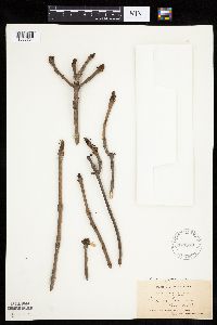 Fraxinus nigra Marshall 171570[1033734]Holzinger, John s.n.1897-05-00 United States, Minnesota, Winona, Bear Creek, Winona Co.;;;;, 44.07528 -91.84667 |
MIN:Plants | 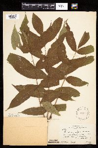 Fraxinus nigra Marshall 229645[1033670]Rosendahl, C. 53761927-08-14 United States, Minnesota, Houston, On flood plain of Root River, 1 mi E of Houston;;;;, 43.76333 -91.54827 |
MIN:Plants | 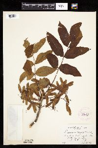 Fraxinus nigra Marshall 276904[1033737]Huff, N. 1191914-07-08 United States, Minnesota, Lake, Shores, North Kawishiwi River;Boundary Waters Canoe Area Wilderness / Superior National Forest;;;, 47.90556 -91.71722 |
MIN:Plants | 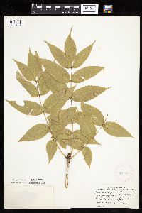 Fraxinus nigra Marshall 282534[1033708]Stevens, O. s.n.1933-09-04 United States, Minnesota, Clay, Along old river bed (just W of station), Muskoda [historic RR station near Hawley];;139N;45W;18, 46.85442 -96.41411 |
MIN:Plants |  Fraxinus nigra Marshall 288048[1033707]Lakela, Olga s.n.1934-04-09 United States, Minnesota, Hennepin, Terrace E of Milwaukee rr Bridge N of the road, Minneapolis;;;;, 44.98 -93.26361 |
MIN:Plants |  Fraxinus nigra Marshall 348014[1033745]Buell, Murray 17771938-06-23 United States, Minnesota, Clearwater, Itasca Park;Itasca State Park;143N;36W;, 47.19557 -95.2332161 |
MIN:Plants |  Fraxinus nigra Marshall 351339[1033717]Benner, F.; Benner, J. 4991929-07-27 United States, Minnesota, Cook, Old trail going N from Grand Portage;Grand Portage National Monument / North Shore;063N;06E;, 47.95847 -89.70358 |
MIN:Plants |  Fraxinus nigra Marshall 358524[1033740]Buell, Murray 18111939-07-05 United States, Minnesota, Clearwater, W side of Lake Itasca;Itasca State Park;143N;36W;, 47.19557 -95.23322 |
MIN:Plants |  Fraxinus nigra Marshall 363161[1033748]Beach, W. 731913-05-11 United States, Minnesota, Ramsey, N end of the Snelling car-line bridge, St. Paul;;;;, 44.9441 -93.0852 |
MIN:Plants |  Fraxinus nigra Marshall 367221[1033680]Moore, John; Butters, F. 134881940-09-04 United States, Minnesota, Carlton, 1/4 mi W of the state line, road E of Barker;;;;, 46.59941 -92.37595 |
MIN:Plants |  Fraxinus nigra Marshall 367603[1033669]Moore, John; et al. 123821940-05-16 United States, Minnesota, Steele, S edge of Owatonna. Steele Co.;;;;, 44.06008 -93.22552 |
MIN:Plants |  Fraxinus nigra Marshall 372172[1033662]Moore, John; et al. 149861941-08-07 United States, Minnesota, Kanabec, NE shore of Knife Lake;;041N;24W;, 46.02597 -93.36921 |
MIN:Plants |  Fraxinus nigra Marshall 373572[1033721]Lakela, Olga 48961942-04-27 United States, Minnesota, Saint Louis, Amity Creek, Duluth;;;;, 46.83889 -92.00667 |
MIN:Plants |  Fraxinus nigra Marshall 373745[1033644]Moore, John; et al. 150661941-08-08 United States, Minnesota, Cass, Cass County...10 mi N of Walker;Chippewa National Forest / Leech Lake Indian Reservation;;;, 47.10284 -94.58694 |
MIN:Plants |  Fraxinus nigra Marshall 373803[1033699]Moore, John; et al. 150781941-08-09 United States, Minnesota, Beltrami, Beltrami County...W shore of Lake Bemidji;;;;, 47.47194 -94.87611 |
MIN:Plants |  Fraxinus nigra Marshall 396872[1033698]Stevens, O. s.n.1948-09-12 United States, Minnesota, Clay, By old channel, W of N.P. Ry. Sta, Muskoda [historic RR station near Hawley];;139N;45W;18, 46.85442 -96.41411 |
MIN:Plants |  Fraxinus nigra Marshall 400580[1033661]Butters, F.; Abbe, E. 7791944-07-30 United States, Minnesota, Cook, Forest S of Partridge Lake; T65N R2W;Boundary Waters Canoe Area Wilderness / Superior National Forest;065N;02W;, 48.08612 -90.18648 |
MIN:Plants |  Fraxinus nigra Marshall 400581[1033742]Butters, F.; Abbe, E. 9331944-08-04 United States, Minnesota, Cook, Near roadside S of Loon Lake;Boundary Waters Canoe Area Wilderness / Superior National Forest;065N;03W;, 48.07694 -90.69278 |
MIN:Plants |  Fraxinus nigra Marshall 407805[1033651]Lakela, Olga 82411949-06-09 United States, Minnesota, Saint Louis, Near Duluth Heights, Duluth;;;;, 46.80083 -92.13167 |
MIN:Plants |  Fraxinus nigra Marshall 412230[1033743]Moore, John; Moore, Marjorie 114261939-08-03 United States, Minnesota, Roseau, Growing on the S side of the Warroad River, Warroad;;;;, 48.90639 -95.29861 |
MIN:Plants |  Fraxinus nigra Marshall 412657[1033701]Moore, John; Moore, Marjorie 110861939-07-24 United States, Minnesota, Lake of the Woods, Angle Inlet;Northwest Angle;168N;34W;, 49.34462 -95.02889 |
MIN:Plants |  Fraxinus nigra Marshall 419050[1033645]Ahlgren, Clifford 4511949-07-23 United States, Minnesota, Lake, Quetico-Superior Wilderness Research Center...Sec. 9 T64N R10W, Lake Co.;Boundary Waters Canoe Area Wilderness / Superior National Forest;064N;10W;09, 48.03165 -91.61886 |
MIN:Plants |  Fraxinus nigra Marshall 420136[1033648]Lakela, Olga 112371950-08-08 United States, Minnesota, Saint Louis, Savanna River terrace at Floodwood;;;;, 46.92917 -92.91944 |
MIN:Plants |  Fraxinus nigra Marshall 421090[1033728]Lakela, Olga 113141950-08-12 United States, Minnesota, Saint Louis, Bank of Lieuna Lake, on Pequaywan Lake Road, NE of Duluth;Cloquet Valley State Forest;;;, 47.09944 -91.98694 |
MIN:Plants |  Fraxinus nigra Marshall 424108[1033718]Emanuel, J. 1631946-09-04 United States, Minnesota, Itasca, County: Itasca. Locality: Nashwauk Township (Stevenson Rd.) [this connects Nashwauk & Hibbing];;057N;22W;00, 47.41438 -93.13223 |
MIN:Plants |  Fraxinus nigra Marshall 428189[1033751]Smith, Welby 191921991-07-08 United States, Minnesota, Koochiching, Franz Jevne State Park. Koochiching Co.; Franz Jevne State Park, in the Rainy River Valley, about 2 mi NE of Birchdale; Koochiching Co.; Franz Jevne State Park, in the Rainy River Valley, about 2 mi NE of Birchdale; T160N R27W SW1/4 of SW1/4 of Sec 26. 160N 27W 26, 48.6427765 -94.078331 |
Google Map
Google Maps is a web mapping service provided by Google that features a map that users can pan (by dragging the mouse) and zoom (by using the mouse wheel). Collection points are displayed as colored markers that when clicked on, displays the full information for that collection. When multiple species are queried (separated by semi-colons), different colored markers denote each individual species.