University of Minnesota
http://www.umn.edu/
612-625-5000
http://www.umn.edu/
612-625-5000
Minnesota Biodiversity Atlas
Bell Museum
Dataset: MIN-Plants
Taxa: Pentaphylacaceae
Search Criteria: excluding cultivated/captive occurrences
1
Page 1, records 1-7 of 7
Bell Museum plants | |
 MIN:Plants | 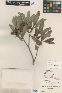 Taonabo pringlei Rose 154311[1002686]Pringle, C.G. 80131899-03-18 Mexico, Morelos, Sierra de Tepoxtlan, 2286m |
MIN:Plants | Ternstroemia cherryi (F.M.Bailey) Merr. ex J.F.Bailey 916800[]Weiblen, G.D. & Binatang Research Center WP1Z30662008-04-11 Papua New Guinea, Madang, Wanang Village, -5.2373 145.177183, 115m |
MIN:Plants | 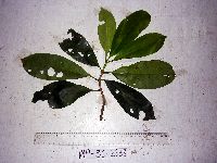 Ternstroemia cherryi (F.M.Bailey) Merr. ex J.F.Bailey 916799[]Weiblen, G.D. & Binatang Research Center WP3C28382007-03-30 Papua New Guinea, Madang, Wanang Village, -5.2373 145.177183, 115m |
MIN:Plants | 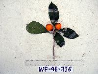 Ternstroemia cherryi (F.M.Bailey) Merr. ex J.F.Bailey 916788[]Weiblen, G.D. & Binatang Research Center WP4B09362007-08-11 Papua New Guinea, Madang, Wanang Village, -5.2373 145.177183, 115m |
MIN:Plants | 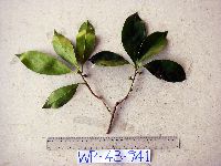 Ternstroemia cherryi (F.M.Bailey) Merr. ex J.F.Bailey 916801[]Weiblen, G.D. & Binatang Research Center WP4B09412007-08-09 Papua New Guinea, Madang, Wanang Village, -5.2373 145.177183, 115m |
MIN:Plants | 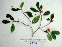 Ternstroemia cherryi (F.M.Bailey) Merr. ex J.F.Bailey 916786[]Weiblen, G.D. & Binatang Research Center WP4C09282007-04-11 Papua New Guinea, Madang, Wanang Village, -5.2373 145.177183, 115m |
MIN:Plants | 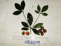 Ternstroemia cherryi (F.M.Bailey) Merr. ex J.F.Bailey 922097[]Ctvrtecka, R. 40612009-02-16 Papua New Guinea, Madang, Wanang Village, -5.23088 145.182, 115m |
1
Page 1, records 1-7 of 7
Google Map
Google Maps is a web mapping service provided by Google that features a map that users can pan (by dragging the mouse) and zoom (by using the mouse wheel). Collection points are displayed as colored markers that when clicked on, displays the full information for that collection. When multiple species are queried (separated by semi-colons), different colored markers denote each individual species.