University of Minnesota
http://www.umn.edu/
612-625-5000
http://www.umn.edu/
612-625-5000
Minnesota Biodiversity Atlas
Bell Museum
Dataset: MIN-Plants
Taxa: Penthoraceae
Search Criteria: excluding cultivated/captive occurrences
Bell Museum plants | |
 MIN:Plants | 508121[]Kaul, R.; et al. 61981988-08-05 United States, Minnesota, Steele, Steele County ... along the Straight River just upstream from Morehouse Park.;;107N;20W;, 44.087641 -93.229074 |
MIN:Plants | 904642[]Lee, Michael MDL37902004-08-13 United States, Minnesota, Todd, TODD COUNTY ... 6 1/2 miles southwest of Staples ... T132N R33W NE1/4 of SW1/4 of NW1/4 Sec.6;;132N;33W;06, 46.274299 -94.886073 |
MIN:Plants | 899020[]Smith, Welby 259041995-08-23 United States, Minnesota, Renville, Skalbakken County Park. Renville County ... Skalbakken County Park ...Minnesota River, about 6 miles east of Granite Falls ... T 115N R 38W SE1/4 of SW1/4 of Sec 27. 115N 38W 27, 44.7347222 -95.4169444 |
MIN:Plants | 910908[]Smith, Welby 247511994-07-14 United States, Minnesota, Koochiching, Along the Big Fork River, about 15 miles south of the town of Big Fork. NW1/4 of NE1/4 of section;Koochiching State Forest;063N;27W;14, 47.9538889 -93.755 |
MIN:Plants | 515487[]Lee, Michael MDL37432004-07-27 United States, Minnesota, Morrison, Camp Ripley Military Reservation. MORRISON COUNTY ... Camp Ripley National Guard Reservation ... Mississippi River six miles north of Fort Ripley ... T132N R29W NW1/4 of SE1/4 of SW1/4 Sec.8. 132N 29W 8, 46.260643 -94.362462 |
MIN:Plants | 485041[]Wheeler, Gerald 202551999-08-03 United States, Minnesota, Sibley, Sibley County ... Ca. 2 mi. SW of Henderson; Rush River State Wayside Park ... S bank of the Rush River ... E1/2 NW1/4 NW1/4 Sec. 22 T112N R26W (Henderson 22). 112N 26W 22, 44.498601 -93.938768 |
MIN:Plants | 914909[]Smith, Welby 252201994-08-19 United States, Minnesota, Pine, Banning State Park. Pine County...In Banning State Park, about 3 miles north-northwest of Sandstone. Along the banks of the Kettle River...T 43N R 20W NW1/4 of SW1/4 of Sec 35. 043N 20W 35, 46.1625 -92.8402778 |
MIN:Plants | 899023[]Smith, Welby 258951995-08-23 United States, Minnesota, Yellow Medicine, Upper Sioux Agency State Park. Yellow Medicine County...Upper Sioux Agency State Park. On the floodplain of the Minnesota River about 5 miles east-southeast of Granite Falls...T 115N R 38W SE1/4 of NW1/4 of Sec 29. 115N 38W 29, 44.7405556 -95.4505556 |
MIN:Plants | 507978[]Lee, Michael; et al. MDL23041998-07-28 United States, Minnesota, Crow Wing, Crow Wing Co. ... along the Little Pine River six miles south-southwest of Emily ... T137N R26W NE1/4 of NE1/4 Sec. 33;;137N;26W;33, 46.642251 -93.970311 |
MIN:Plants | 122160[]Sheldon, Edmund S70461893-09-00 United States, Minnesota, Traverse, Browns Valley;;N;;, 45.595226 -96.833504 |
MIN:Plants | 122161[]Sheldon, Edmund S32801892-07-00 United States, Minnesota, Mille Lacs, Bridgeman [other collections by Sheldon indicated Mille Lacs Co.; original name for current town of Foreston];;037n;27W;33, 45.65603 -93.707991 |
MIN:Plants | 122162[]Anderson, A. s.n.1893-08-00 United States, Minnesota, Goodhue, Belle Creek.;;N;;, 44.550382 -92.724728 |
MIN:Plants | 122163[]Sandberg, John s.n.1889-07-00 United States, Minnesota, Hennepin, [no further data];;;;, 45 -93.47 |
MIN:Plants | 122164[]Illegible name 561900-07-19 United States, Minnesota, [no further data];;;;, 46 -94 |
MIN:Plants | 122165[]Campbell, Jennie C231896-07-00 United States, Minnesota, Stearns, Braun's farm. Stearns Co.;;N;;, 45.557693 -94.1603 |
MIN:Plants | 122166[]Sandberg, John s.n.1881-09-00 United States, Minnesota, Goodhue, Cannon Falls;;112N;17W;, 44.506911 -92.905484 |
MIN:Plants | 122167[]Anderson, A. An7561893-08-00 United States, Minnesota, Goodhue, Belle Creek;;N;;, 44.550382 -92.724728 |
MIN:Plants | 122169[]Herrick, C. s.n.1878-07-22 United States, Minnesota, Hennepin, Minneapolis;;N;;, 44.979965 -93.263836 |
MIN:Plants | 122170[]Holzinger, John s.n.1886-06-00 United States, Minnesota, Winona, Winona Co.;;N;;, 43.98685 -91.779129 |
MIN:Plants | 122171[]Sheldon, Edmund S15711891-08-00 United States, Minnesota, Lincoln, Lake Benton;;109N;45W;, 44.24108 -96.26172 |
MIN:Plants | 122172[]Ballard, C. B6111891-07-00 United States, Minnesota, Carver, Chaska;;N;;, 44.789407 -93.602179 |
MIN:Plants | 122173[]Ballard, C. B6941891-07-00 United States, Minnesota, Carver, Waconia;;116N;25W;, 44.850796 -93.786909 |
MIN:Plants | 122174[]Taylor, B. T14911892-07-00 United States, Minnesota, Chisago, Center City;;N;;, 45.389814 -92.821151 |
MIN:Plants | 122175[]Aiton, G. s.n.1889-07-00 United States, Minnesota, Hennepin, [no further data];;;;, 45 -93.47 |
MIN:Plants | 122176[]MacMillan, C.; et al. 231Sk1900-08-00 United States, Minnesota, Polk, Crookston;;150N;46W;30, 47.782 -96.60007 |
MIN:Plants | 122177[]Ballard, C. B8131891-08-00 United States, Minnesota, Carver, Page Lake;;N;;, 44.820759 -93.802586 |
MIN:Plants | 122178[]Ballard, C. B4441891-07-00 United States, Minnesota, Scott, Prior Lake;;N;;, 44.720982 -93.425645 |
MIN:Plants | 122179[]G. & L. s.n.1885-08-00 United States, Minnesota, Nelson's grove.;;;;, 45.889407 -95.2642 |
MIN:Plants | 122180[]Sheldon, Edmund S11971891-07-00 United States, Minnesota, Brown, New Ulm;;110N;30W;, 44.315266 -94.452293 |
MIN:Plants | 122181[]Sheldon, Edmund S32441892-07-00 United States, Minnesota, Mille Lacs, Milaca;;037N;27W;, 45.755799 -93.654408 |
MIN:Plants | 122182[]Manning, Sara s.n.1883-08-15 United States, Minnesota, Wabasha, Lake City;;N;;, 44.449412 -92.266844 |
MIN:Plants | 122184[]Rosendahl, C.; et al. s.n.1917-09-00 United States, Minnesota, Anoka, Moore Lake.;;030N;24W;, 45.077013 -93.252399 |
MIN:Plants | 122185[]Wheeler, William 11051901-09-13 United States, Minnesota, Rock, Luverne;;N;;, 43.654136 -96.212807 |
MIN:Plants | 122186[]Wheeler, William 3841899-07-21 United States, Minnesota, Houston, Jefferson;Dorer Memorial Hardwood State Forest;101N;04W;35, 43.50806 -91.28287 |
MIN:Plants | 122187[]Ballard, C. 27801900-08-00 United States, Minnesota, Marshall, Warren;;N;;, 48.196642 -96.77284 |
MIN:Plants | 123168[]Ballard, C. B11401892-08-00 United States, Minnesota, Goodhue, Zumbrota;;109N;16W;, 44.294132 -92.669081 |
MIN:Plants | 264349[]White, Sidney s.n.1887-07-00 United States, Minnesota, Winona, Lake Winona;;107N;07W;, 44.0525878 -91.6726869 |
MIN:Plants | 264350[]White, Sidney s.n.1884-07-00 United States, Minnesota, Winona, Lake Winona;;107N;07W;, 44.0525878 -91.6726869 |
MIN:Plants | 267047[]Stevenson, J. 2821912-08-02 United States, Minnesota, Beltrami, Bemidji;;N;;, 47.536341 -94.82277 |
MIN:Plants | 267048[]Stevenson, J. 2821912-08-02 United States, Minnesota, Beltrami, Bemidji;;N;;, 47.536341 -94.82277 |
MIN:Plants | 277593[]Hotchkiss, N.; et al. 2911930-07-16 United States, Minnesota, Brown, Lake Hanska. Brown Co.;;;;, 44.145015 -94.61931 |
MIN:Plants | 281370[]Roberts, Thomas s.n.1878-08-26 United States, Minnesota, Hennepin, Minneapolis;;N;;, 44.979965 -93.263836 |
MIN:Plants | 337009[]Lakela, Olga 16661936-08-08 United States, Minnesota, Saint Louis, Oatka Beach Addition, Duluth;Minnesota Point;049N;13W;18, 46.7833 -92.1 |
MIN:Plants | 338170[]Rosendahl, C.; Moyle, J. 21761936-07-18 United States, Minnesota, Koochiching, Koochiching Co.; Near the mouth of the Big Fork River;;070N;26W;, 48.515732 -93.716342 |
MIN:Plants | 360341[]Rosendahl, C. 64971933-09-09 United States, Minnesota, Aitkin, Mille Lacs [Lake], N of Garrison;;044N;27W;05, 46.327131 -93.776539 |
MIN:Plants | 360571[]Lakela, Olga 42551940-09-14 United States, Minnesota, Saint Louis, St. Louis River bottom at Fond du Lac;;048N;15W;, 46.659664 -92.273248 |
MIN:Plants | 361749[]Jacobs, D. 3321940-07-17 United States, Minnesota, Wright, Wright Co.; Cedar Lake shore;;N;;, 45.269311 -94.064646 |
MIN:Plants | 361935[]Rosendahl, C. 67901936-09-13 United States, Minnesota, Goodhue, Banks of Cannon River, above bridge, hwy 61;;N;;, 44.563393 -92.554753 |
MIN:Plants | 366500[]Rosendahl, C.; et al. 72371939-07-20 United States, Minnesota, Freeborn, Along Iowa-Minn. State line, E of Emmons.;;;;, 43.499938 -93.478784 |
MIN:Plants | 367440[]Moore, John; Moore, Marjorie 103041938-08-11 United States, Minnesota, Goodhue, Banks of Prairie Creek, 2 mi. N of Stanton.;;N;;, 44.563393 -92.554753 |
MIN:Plants | 368419[]Manning, Sara s.n.1884-05-08 United States, Minnesota, Goodhue, Central Point [pioneer town on Sand Point, Lake Pepin];Frontenac State Park;112N;13W;12, 44.51982 -92.31912 |
MIN:Plants | 370663[]Moore, John; Moore, Marjorie 136331940-09-28 United States, Minnesota, Ramsey, Ramsey County...Rice Creek, SW1/4 Sec. 9, Mounds View Twp.;;030N;23W;09, 45.097461 -93.182949 |
MIN:Plants | 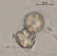 385618[]Moyle, J. 40571945-08-29 United States, Minnesota, Winona, Upper Money Creek. Winona Co. [near St. Charles or near Witoka?];;;;, 43.968011 -92.06563 |
MIN:Plants | 386276[]Lakela, Olga 58511944-09-04 United States, Minnesota, Carlton, Along Great Northern R.R. tracks ca. 3 mi. S of Holyoke.;;N;;, 46.42401 -92.388528 |
MIN:Plants | 392911[]Lakela, Olga 73011947-09-02 United States, Minnesota, Saint Louis, Shore of St. Louis River near Brookston;;N;;, 46.86772 -92.603804 |
MIN:Plants | 396824[]Stevens, O. s.n.1947-07-18 United States, Minnesota, Clay, [no further data];Buffalo River State Park;139N;46W;10, 46.863699 -96.472855 |
MIN:Plants | 412328[]Moore, John; Moore, Marjorie 120481939-08-23 United States, Minnesota, Koochiching, On the E bank of the Big Fork River near the mouth; Reedy Twp.;;070N;26W;, 48.515732 -93.716342 |
MIN:Plants | 412387[]Moore, John; Moore, Marjorie 120041939-08-22 United States, Minnesota, Lake of the Woods, Shore at the mouth of the Rapid River, Clementson;;N;;, 48.6833 -94.4333 |
MIN:Plants | 412668[]Moore, John; Moore, Marjorie 119631939-08-21 United States, Minnesota, Roseau, Along the S bank of the Roseau River at Ross; Dieter Twp.;;N;;, 48.910169 -95.920178 |
MIN:Plants | 412718[]Moore, John; Moore, Marjorie 115431939-08-08 United States, Minnesota, Kittson, 1 1/2 mi. E of Northcote.;;N;;, 48.845256 -96.968184 |
MIN:Plants | 416708[]Lakela, Olga 90601949-07-20 United States, Minnesota, Saint Louis, Shore of Prairie River, SW part of the Co.;;N;;, 46.7833 -92.9 |
MIN:Plants | 419368[]Lakela, Olga 110111950-07-30 United States, Minnesota, Saint Louis, Shore of Savanna River at Floodwood.;;051N;20W;, 46.92911 -92.919648 |
MIN:Plants | 422593[]Lakela, Olga 78671948-09-18 United States, Minnesota, Saint Louis, Shore of the St. Louis River near Floodwood.;;N;;, 46.92911 -92.919648 |
MIN:Plants | 422667[]Lakela, Olga 78151948-09-08 United States, Minnesota, Saint Louis, Shore of the St. Louis River at Paupores Station.;;N;;, 46.872444 -92.764364 |
MIN:Plants | 427290[]Boe, J. 980724011998-07-24 United States, Minnesota, Aitkin, Aitkin Co.; Kimberly Wildlife Management Area. Floodplain forest along Rice River' T47N R24W SE1/4 of SE1/4 of sec 9;Kimberly Wildlife Management Area;047N;24W;9, 46.565292 -93.372798 |
MIN:Plants | 427677[]Smith, Welby 139691987-09-26 United States, Minnesota, Sherburne, Sherburne Co. In Sherburne National Wildlife Refuge, about 3 mi NE of Orrock. NE1/4 SW1/4 sec 34, T35N R27W;Sherburne National Wildlife Refuge;035N;27W;34, 45.4791679 -93.6875 |
MIN:Plants | 434837[]Myhre, K. 4941991-07-22 United States, Minnesota, Aitkin, Aitkin Co.; 12 miles South of Jacobson; T 50N R 24W NE1/4 of SW1/4 of sec 12;;050N;24W;12, 46.830592 -93.328541 |
MIN:Plants | 439999[]Myhre, K. 44451993-08-10 United States, Minnesota, Pine, Saint Croix State Forest. Pine Co. Located just E of the public access to the St. Croix River, one half mile N of Danbury; T41N R16W SE1/4 of SE14 Pine Co. Located just E of the public access to the St. Croix River, one half mile N of Danbury; T41N R16W SE1/4 of SE14 of Sec 21. 041N 16W 21, 46.020737 -92.372456 |
MIN:Plants | 440191[]Smith, Welby 143551988-06-26 United States, Minnesota, Aitkin, Aitkin Co. On the N bank of the Mississippi River, about 2 1/2 mi SW of Palisade; NW1/4 NW1/4 sec.33, T49N R25W;;049N;25W;33, 46.6933327 -93.523613 |
MIN:Plants | 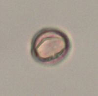 442478[]Lakela, Olga 135171951-07-25 United States, Minnesota, Saint Louis, Shore of Swan River, at Hwy. 73, S of Hibbing.;;N;;, 47.427155 -92.937689 |
MIN:Plants | 444589[]Dahle, R. 970641997-09-10 United States, Minnesota, Aitkin, Wealthwood State Forest. Aitkin County...In Wealthwood State Forest, about one half mile north of Highway #18, just north of the parking area at the north end of the North Shore Forest Road. T 45 R 27 SW1/4 of SE1/4 of Sec 24. 045N 27W 24, 46.3622222 -93.6944444 |
MIN:Plants | 444726[]Moore, John; Huff, N. 197421947-08-08 United States, Minnesota, Morrison, Along the Swan River, 5 mi. SW of Little Falls.;;N;;, 45.927768 -94.437814 |
MIN:Plants | 446290[]Moore, John; Huff, N. 188391946-07-31 United States, Minnesota, Benton, Along Mayhew Creek, Mayhew Creek Valley NE of East St. Cloud.;;N;;, 45.616101 -94.111979 |
MIN:Plants | 448314[]Moore, John; Huff, N. 192251946-09-06 United States, Minnesota, Washington, William O'Brien State Park.;William O'Brien State Park;032N;19W;, 45.217153 -92.76414 |
MIN:Plants | 448658[]Moore, John; Huff, N. 193361946-10-03 United States, Minnesota, Jackson, Kilen Woods State Park;Kilen Woods State Park;103N;35W;17, 43.72505 -95.064623 |
MIN:Plants | 448678[]Moore, John; Huff, N. 192771946-09-12 United States, Minnesota, Chippewa, Chippewa River, Watson State Scenic Park. Chippewa Co.;;118N;41W;, 45.00968 -95.801418 |
MIN:Plants | 448691[]Moore, John; Huff, N. 192921946-09-14 United States, Minnesota, Scott, Jordan;;114N;23W;, 44.66532 -93.627759 |
MIN:Plants | 449295[]Moore, John; Huff, N. 178811945-07-24 United States, Minnesota, Morrison, Darling;;N;;, 46.027543 -94.442035 |
MIN:Plants | 453226[]Smith, Welby 146681988-08-04 United States, Minnesota, Mille Lacs, Mille Lacs County...About 11 miles north of Milaca...in Rum River...SW1/4 SE1/4 section 26, T 40N R 27W;;040N;27W;26, 45.925 -93.6680556 |
MIN:Plants | 453657[]Husveth, J. 95-37261995-09-12 United States, Minnesota, Winona, Winona Co, T107N R10W SW1/4 of the SE1/4 of S6; North Fork of the Whitewater River.;Whitewater Wildlife Management Area;T107N R10W S6, 44.084603 -92.021648 |
MIN:Plants | 458942[]Smith, Welby 146271988-07-25 United States, Minnesota, Kanabec, Kanabec County...on the west bank of the Snake River, just south of the Highway 3 crossing; NE1/4 NW1/4 sec. 22, T 41N R 23W. 041N 23W 22, 46.0238889 -93.2333333 |
MIN:Plants | 505799[]Husveth, J. 95-32471995-09-04 United States, Minnesota, Goodhue, Goodhue Co, T113N R15W SE1/4 of the NE1/4 of S19; Cannon River adjacent to recent road construction.;Dorer Memorial Hardwood State Forest;113N;15W;19, 44.578883 -92.662146 |
MIN:Plants | 507181[]Moore, John 209041950-09-26 United States, Minnesota, Pipestone, Pipestone Co.; Bank of creek 1.5 miles north of Holland;;108N;44W;, 44.11336 -96.188642 |
MIN:Plants | 514690[]Husveth, J. 95-45321995-08-31 United States, Minnesota, Wabasha, Wabasha Co, T110N R12W SW1/4 of the SE1/4 of S27; Zumbro River;Dorer Memorial Hardwood State Forest;110N;12W;27, 44.212766 -92.479382 |
MIN:Plants | 514692[]Husveth, J. 95-33341995-09-05 United States, Minnesota, Goodhue, Goodhue Co, T113N R16W NE1/4 of the SW1/4 of S25; Cannon River;Dorer Memorial Hardwood State Forest;113N;16W;25, 44.56323 -92.684577 |
MIN:Plants | 514694[]Husveth, J. 95-17441995-09-04 United States, Minnesota, Goodhue, Goodhue Co, T113N R15W SE1/4 of the NE1/4 of S19; along Cannon River;Dorer Memorial Hardwood State Forest;113N;15W;19, 44.578883 -92.662146 |
MIN:Plants | 518735[]Gerdes, Lynden 23251997-08-13 United States, Minnesota, Aitkin, Rice Lake National Wildlife Refuge. Aitkin Co.; T47N R24W S25NENW. Aitkin Co.; Rice Lake NWR, approx. 5.0 miles S of McGregor, along the banks of the Rice R Aitkin Co.; T47N R24W S25NENW. Aitkin Co.; Rice Lake NWR, approx. 5.0 miles S of McGregor, along the banks of the Rice River.. 047N 24W 25, 46.53178 -93.319689 |
MIN:Plants | 525706[]Lakela, Olga 189201955-07-21 United States, Minnesota, Saint Louis, Shore of Vermilion River above the Falls;;N;;, 48.275739 -92.506548 |
MIN:Plants | 549890[]Moore, John 221161954-09-15 United States, Minnesota, Sherburne, Along the banks of the Elk River, 2 mi. N of Becker.;;N;;, 45.425231 -93.876408 |
MIN:Plants | 549912[]Moore, John; et al. 221711954-09-20 United States, Minnesota, Lyon, Lyon County...3 mi. E of Balaton;;;;, 44.232595 -95.92678 |
MIN:Plants | 550250[]Moore, John; et al. 222361954-09-21 United States, Minnesota, Pipestone, Pipestone County...2 miles northeast of Ihlen.;;105N;46W;, 43.902048 -96.363857 |
MIN:Plants | 558403[]Moore, John; Hsi, Yu-tseng [Eugene] 233961957-08-07 United States, Minnesota, Blue Earth, Along the river at Mankato Springs. Sec. 29, SW1/4 Le Ray Twp.;;N;;, 44.130505 -93.978801 |
MIN:Plants | 566423[]Moore, John; Heig, V. 240411958-09-09 United States, Minnesota, Kittson, 1 mi. N of Hallock;;N;;, 48.788898 -96.946447 |
MIN:Plants | 572444[]Moore, John; et al. 257891961-08-17 United States, Minnesota, Martin, Martin County...Trimont Prairie; SE1/4 Sec. 9 T103N R32W;;103N;32W;09, 43.739873 -94.684695 |
MIN:Plants | 572882[]Moore, John 255521961-07-05 United States, Minnesota, Anoka, Near the entrance to Cedar Creek Natural History Area laboratory grounds.;Cedar Creek National History Area;034N;23W;, 45.40217 -93.199397 |
MIN:Plants | 574973[]Wertman, Freida 3541960-09-27 United States, Minnesota, Anoka, Cedar Creek Natural History Area. Athens Twp. Sec. 27. Co. Rd. 24.;Cedar Creek National History Area;034N;23W;27, 45.319728 -93.316639 |
MIN:Plants | 580420[]Stevens, O. 23591960-09-24 United States, Minnesota, Clay, Glyndon;;139N;47W;00, 46.873333 -96.58 |
MIN:Plants | 584497[]Ownbey, Gerald 35711963-07-24 United States, Minnesota, Norman, T144N, R44W, SW1/4 Sec. 16. At the crossing of Wild River River. Hwy. 32, just N of Twin Valley. Along a creek at pic T144N, R44W, SW1/4 Sec. 16. At the crossing of Wild River River. Hwy. 32, just N of Twin Valley. Along a creek at picnic ground just N of the river.. 144N 44W 16, 47.288839 -96.269219 |
MIN:Plants | 585358[]Moore, John 262321962-10-19 United States, Minnesota, Blue Earth, 1 mi. N of Mankato;;N;;, 44.178061 -93.9994 |
MIN:Plants | 592394[]Westkaemper, Remberta s.n.1964-07-00 United States, Minnesota, Stearns, St. Joseph. St. Benedict's [College] pasture.;;124N;29W;, 45.564772 -94.317966 |
Google Map
Google Maps is a web mapping service provided by Google that features a map that users can pan (by dragging the mouse) and zoom (by using the mouse wheel). Collection points are displayed as colored markers that when clicked on, displays the full information for that collection. When multiple species are queried (separated by semi-colons), different colored markers denote each individual species.