University of Minnesota
http://www.umn.edu/
612-625-5000
http://www.umn.edu/
612-625-5000
Minnesota Biodiversity Atlas
Bell Museum
Dataset: MIN-Plants
Taxa: Pontederiaceae
Search Criteria: excluding cultivated/captive occurrences
Bell Museum plants | |
 MIN:Plants | Heteranthera dubia (Jacquin) MacMillan 907054[]Lee, Michael MDL45642007-09-13 United States, Minnesota, Roseau, Hayes Lake State Park. Roseau County...Hayes Lake State Park...Roseau River 8.5 miles east of Wannaska, 17.5 miles southeast of Roseau ...Just below the Hayes Lake dam...T160N R38W SW1/4 of SW1/4 of NE1/4 Sec.33 ... UTM: 5389971N 312203E. 160N 38W 33, 48.634617 -95.54897 |
MIN:Plants | Heteranthera dubia (Jacquin) MacMillan 910531[]Loso, Stephanie; et al. 15292008-07-08 United States, Minnesota, Cass, County: Cass, Lake ID: 11004300, Lake: Roosevelt...T139, R26W, Sec33. West bay, DNR site # 933;Land O Lakes State Forest;139N;26W;33, 46.818643 -93.946299 |
MIN:Plants | Heteranthera dubia (Jacquin) MacMillan 264297[]Holzinger, John s.n.1901-08-00 United States, Minnesota, Winona, Winona Co.;;N;;, 43.98685 -91.779129 |
MIN:Plants | Heteranthera dubia (Jacquin) MacMillan 265680[]Ballard, C. 2895a1901-08-09 United States, Minnesota, Clay, Red River Valley, near Moorhead.;;N;;, 46.873852 -96.767581 |
MIN:Plants | Heteranthera dubia (Jacquin) MacMillan 265681[]Ballard, C. 2895a1901-08-02 United States, Minnesota, Clay, Red River Valley, near Moorhead.;;N;;, 46.873852 -96.767581 |
MIN:Plants | Heteranthera dubia (Jacquin) MacMillan 266996[]Goldsmith, G. G3501912-00-00 United States, Minnesota, Rice, Northfield.;;N;;, 44.458298 -93.161604 |
MIN:Plants | Heteranthera dubia (Jacquin) MacMillan 268454[]Kreuholz, R. 1691929-09-03 United States, Minnesota, Big Stone, Big Stone Lake.;;122N;46W;, 45.304687 -96.444779 |
MIN:Plants | Heteranthera dubia (Jacquin) MacMillan 275930[]Grant, Martin 32021929-09-03 United States, Minnesota, Clearwater, Itasca State Park. Lake Itasca.;Itasca State Park;143N;36W;11, 47.218013 -95.200853 |
MIN:Plants | Heteranthera dubia (Jacquin) MacMillan 277816[]Roberts, Thomas s.n.1878-08-05 United States, Minnesota, Hennepin, Lake Minnetonka.;;N;;, 44.917794 -93.610061 |
MIN:Plants | Heteranthera dubia (Jacquin) MacMillan 306059[]Delaney, B. s.n.1987-09-26 United States, Minnesota, Anoka, Anoka Co. Cedar Creek Natural History Area. E shore of Fish Lake.;Cedar Creek National History Area;034N;23W;25, 45.402965 -93.16682 |
MIN:Plants | Heteranthera dubia (Jacquin) MacMillan 306553[]Oosting, H. 30431930-08-23 United States, Minnesota, Hennepin, Lake Minnetonka - Navarre.;;N;;, 44.915692 -93.617487 |
MIN:Plants | Heteranthera dubia (Jacquin) MacMillan 306557[]Oosting, H. 29151929-07-19 United States, Minnesota, Anoka, Ham Lake.;;032N;23W;, 45.257018 -93.222366 |
MIN:Plants | Heteranthera dubia (Jacquin) MacMillan 306558[]Oosting, H. 29401929-08-04 United States, Minnesota, Scott, Prior Lake.;;N;;, 44.720982 -93.425645 |
MIN:Plants | Heteranthera dubia (Jacquin) MacMillan 306559[]Oosting, H. 1929-09-17 United States, Minnesota, Washington, Echo lake, Washington Co.;;030N;21W;17, 45.086356 -92.959415 |
MIN:Plants | Heteranthera dubia (Jacquin) MacMillan 306788[]Moyle, J. 24421935-09-20 United States, Minnesota, Saint Louis, Pelican Lake.;Kabetogama State Forest;N;;, 48.07265 -92.934264 |
MIN:Plants | Heteranthera dubia (Jacquin) MacMillan 307058[]Moyle, J. 25221935-09-23 United States, Minnesota, Saint Louis, Trunk of Elephant Lake.;;066N;19W;, 48.193442 -92.744804 |
MIN:Plants | Heteranthera dubia (Jacquin) MacMillan 337985[]Smith, L.; Moyle, J. 2861936-08-14 United States, Minnesota, Itasca, Maple Lake;Chippewa National Forest;060N;27W;, 47.64748 -93.722135 |
MIN:Plants | Heteranthera dubia (Jacquin) MacMillan 338185[]Moyle, J. 23221937-08-30 United States, Minnesota, Douglas, Lake Henry at Alexandria.;;N;;, 45.902163 -95.376156 |
MIN:Plants | Heteranthera dubia (Jacquin) MacMillan 347646[]Moyle, J. 31771938-08-12 United States, Minnesota, Pine, Pokegama [Lake]. Pine Co.;;039N;22W;, 45.844481 -93.038698 |
MIN:Plants | Heteranthera dubia (Jacquin) MacMillan 347715[]Moyle, J. 28301937-08-11 United States, Minnesota, Winona, Mississippi River, at Winona.;;107N;07W;, 44.037463 -91.687677 |
MIN:Plants | Heteranthera dubia (Jacquin) MacMillan 347730[]Moyle, J. 20861935-09-06 United States, Minnesota, Scott, Prior Lake.;;N;;, 44.720982 -93.425645 |
MIN:Plants | Heteranthera dubia (Jacquin) MacMillan 347737[]Moyle, J. 29141937-08-14 United States, Minnesota, Martin, Hall Lake, at Fairmont.;;N;;, 43.624955 -94.461736 |
MIN:Plants | Heteranthera dubia (Jacquin) MacMillan 359029[]Moyle, J. 33941939-08-14 United States, Minnesota, Sherburne, Elk River at Elk River.;;N;;, 45.384459 -93.833304 |
MIN:Plants | Heteranthera dubia (Jacquin) MacMillan 359030[]Moyle, J. 33951939-07-28 United States, Minnesota, Morrison, Swan River, near Little Falls.;;N;;, 45.976354 -94.362502 |
MIN:Plants | Heteranthera dubia (Jacquin) MacMillan 359031[]Moyle, J. 33931939-09-12 United States, Minnesota, Wadena, Wadena Co. Crow Wing River.;;N;;, 46.480067 -94.98064 |
MIN:Plants | Heteranthera dubia (Jacquin) MacMillan 360407[]Rosendahl, C. 64881933-09-08 United States, Minnesota, Clearwater, In front of the boat-house, Itasca [State] Park.;Itasca State Park;143N;36W;, 47.197458 -95.201964 |
MIN:Plants | Heteranthera dubia (Jacquin) MacMillan 364305[]Rosendahl, C. 64351933-08-11 United States, Minnesota, Ramsey, Snail Lake.;Snail Lake Vadnais Lake County Park;030N;23W;, 45.070121 -93.120131 |
MIN:Plants | Heteranthera dubia (Jacquin) MacMillan 420753[]Lakela, Olga 121881950-09-10 United States, Minnesota, Saint Louis, Island Lake, S of Hibbing on hwy. 73.;;N;;, 47.019814 -92.145172 |
MIN:Plants | 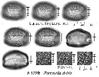 Heteranthera dubia (Jacquin) MacMillan 425831[]Emanuel, J. 5511951-07-19 United States, Minnesota, Winona, Just N of Dam 5A (Winona).;;107N;07W;, 44.052587 -91.6726869 |
MIN:Plants | Heteranthera dubia (Jacquin) MacMillan 430689[]Coulombe-Moore, M.; et al. 1110UM1996-07-26 United States, Minnesota, Wabasha, Wabasha County...Pool 4. River Mile 758.0...UTM: E579336 N4912875. Robinson Lake;Upper Mississippi National Wildlife Refuge;T111N R10W S03, 44.38 -92.045 |
MIN:Plants | Heteranthera dubia (Jacquin) MacMillan 437439[]Moore, John; Moore, Marjorie 121411939-08-26 United States, Minnesota, Lake of the Woods, On the W side of Baudette Bay, Baudette.;;160N;31W;, 48.712474 -94.59993 |
MIN:Plants | Heteranthera dubia (Jacquin) MacMillan 440514[]Smith, Welby 148971988-08-17 United States, Minnesota, Meeker, Meeker County...At the SW end of Round Lake, about 3 mi S-SE of Litchfield...at the public access...NW1/4 NE1/4 sec.36, T119N R31W. 119N 31W 36, 45.0777778 -94.5105556 |
MIN:Plants | Heteranthera dubia (Jacquin) MacMillan 445280[]Myhre, K. 58331995-07-06 United States, Minnesota, Aitkin, Aitkin Countty...Located 2.5 miles southeast of the town of Giese. Plants occur along the south bay of Big Pine Lake...T 43N R 22W SW1/4 of NE1/4 of Sec 24. 043N 22W 24, 46.196977 -93.062078 |
MIN:Plants | Heteranthera dubia (Jacquin) MacMillan 456668[]Winkelman, J.; Hoffmann, J. 1047UM1996-07-12 United States, Minnesota, Wabasha, Upper Mississippi National Wildlife Refuge. Upper Mississippi River Corridor...Wabasha Co.; Pool 5, River Mile 747.6...UTM E587220 N4901636...Martin's Slough, S of road leading to Half Moon boat landing.. , 44.2666664 -91.9000015 |
MIN:Plants | Heteranthera dubia (Jacquin) MacMillan 460550[]Smith, Welby 146421988-07-25 United States, Minnesota, Kanabec, Kanabec County...On the west bank of the Snake River, just south of the Highway 3 crossing; NE1/4 NW1/4 section 22, T 41N R 23W. 041N 23W 22, 46.0238889 -93.2333333 |
MIN:Plants | Heteranthera dubia (Jacquin) MacMillan 471987[]Smith, Welby 148341988-08-12 United States, Minnesota, Washington, Lake Elmo County Park. Washington Co.; at the southwest end of Lake Elmo, about one mile south of the town of Lake Elmo; NW1/4 NE1/4 sec.26, T Washington Co.; at the southwest end of Lake Elmo, about one mile south of the town of Lake Elmo; NW1/4 NE1/4 sec.26, T 29N R 21W. 029N 21W 26, 44.9772224 -92.8911133 |
MIN:Plants | Heteranthera dubia (Jacquin) MacMillan 476474[]Myhre, K. 68221997-07-04 United States, Minnesota, Morrison, Morrison Co.; Sullivan Lake. Located 15 miles northeast of the town of Pierz. Plants occur along the north bay of the la Morrison Co.; Sullivan Lake. Located 15 miles northeast of the town of Pierz. Plants occur along the north bay of the lake; T 42N R 29W SW1/4 of NE1/4 of sEc 1. 042N 29W 1, 46.149497 -93.946975 |
MIN:Plants | Heteranthera dubia (Jacquin) MacMillan 491686[]Lakela, Olga 165871953-08-06 United States, Minnesota, Saint Louis, Lac La Croix, S of Lac La Croix Resort.;Boundary Waters Canoe Area Wilderness / Superior National Forest;N;;, 48.3333 -92.1167 |
MIN:Plants | Heteranthera dubia (Jacquin) MacMillan 505847[]Smith, Welby 146831988-08-04 United States, Minnesota, Mille Lacs, Mille Lacs Co.; About 11 miles north of Milaca; Rum River; SW1/4 SE1/4 section 26, T 40N R 27W;;040N;27W;26, 45.9249992 -93.6680527 |
MIN:Plants | Heteranthera dubia (Jacquin) MacMillan 515652[]Smith, Welby 179111990-08-08 United States, Minnesota, Pennington, Pennington County...at the SE end of the town of St. Hilaire...Red Lake River...T 152N R 43W SE1/4 of SE1/4 of Sec 6;;152N;43W;06, 48.0077778 -96.205 |
MIN:Plants | Heteranthera dubia (Jacquin) MacMillan 519816[]Winkelman, J.; Hoffmann, J. 1056UM1996-07-19 United States, Minnesota, Winona, Upper Mississippi National Wildlife Refuge. Upper Mississippi River Corridor...Winona Co.; Pool 5A, River Mile 732.4...UTM E600816 N4884367...narrow channel located between Burleigh Slough and Twin Lakes.. , 44.0999985 -91.7333298 |
MIN:Plants | Heteranthera dubia (Jacquin) MacMillan 519830[]Winkelman, J.; Hoffmann, J. 1056UM1996-07-19 United States, Minnesota, Winona, Upper Mississippi National Wildlife Refuge. Upper Mississippi River Corridor...Winona Co.; Pool 5A, River Mile 732.4...UTM E600816 N4884367...narrow channel located between Burleigh Slough and Twin Lakes.. , 44.0999985 -91.7333298 |
MIN:Plants | Heteranthera dubia (Jacquin) MacMillan 527931[]Fallstad, R.; Helbig, V. s.n.1955-08-09 United States, Minnesota, Ramsey, Ramsey Co.; Round Lake. Sec. 21 T 30N R 23W;;030N;23W;21, 45.070057 -93.176955 |
MIN:Plants | Heteranthera dubia (Jacquin) MacMillan 57947[]Wheeler, William 10881901-09-13 United States, Minnesota, Rock, Rock River, Luverne.;;102N;45W;, 43.654136 -96.212807 |
MIN:Plants | Heteranthera dubia (Jacquin) MacMillan 57990[]Wheeler, William 4901899-08-09 United States, Minnesota, Houston, Jefferson;Dorer Memorial Hardwood State Forest;101N;04W;35, 43.50806 -91.28287 |
MIN:Plants | Heteranthera dubia (Jacquin) MacMillan 594117[]Thorne, Robert 310331962-07-13 United States, Minnesota, Clearwater, Clearwater County...Off Bear Paw Point, Lake Itasca, Itasca State Park.;Itasca State Park;143N;36W;11, 47.218013 -95.200853 |
MIN:Plants | Heteranthera dubia (Jacquin) MacMillan 607052[]Ownbey, Gerald; et al. 41951968-08-12 United States, Minnesota, Clearwater, Clearwater County...Lake Itasca, Itasca State Park. Just below Peace Pipe Springs overlook.;Itasca State Park;143N;36W;12, 47.217691 -95.180249 |
MIN:Plants | Heteranthera dubia (Jacquin) MacMillan 681419[]Swanson, Steven 11921975-07-07 United States, Minnesota, Houston, Mississippi River (Navigation Pool #8). Housto Co.;Upper Mississippi National Wildlife Refuge;N;;, 43.575557 -91.264979 |
MIN:Plants | Heteranthera dubia (Jacquin) MacMillan 696620[]Smith, Welby 7131978-08-15 United States, Minnesota, Wright, Wright Co.; T. 122N. R. 27W. N.E.1/4 section 21. East bank of Clearwater River.;;T122N R27W S21, 45.363873 -94.084003 |
MIN:Plants | Heteranthera dubia (Jacquin) MacMillan 697866[]Ownbey, Gerald 52701976-08-12 United States, Minnesota, Becker, Becker Co. Twin Island Lake. T142N R36W Sec.6 NE1/4;Itasca State Park;142N;36W;6, 47.139422 -95.277979 |
MIN:Plants | Heteranthera dubia (Jacquin) MacMillan 739531[]Sohmer, S. 72441972-07-16 United States, Minnesota, Houston, Blue Lake area; behind Food Bonanza and La Crescent Mobile Homes;;104N;04W;, 43.828022 -91.304027 |
MIN:Plants | Heteranthera dubia (Jacquin) MacMillan 745948[]Smith, Welby 57651981-09-13 United States, Minnesota, Wright, Cedar Lake, ca. 5 mi. SW of Monticello.;;121N;25W;30, 45.263182 -93.873624 |
MIN:Plants | Heteranthera dubia (Jacquin) MacMillan 746466[]Smith, Welby 57071981-09-05 United States, Minnesota, Wright, On the E bank of the Clearwater River, ca. 1/4 mi. S of its confluence with the Mississippi River.;;123N;27W;35, 45.421949 -94.054501 |
MIN:Plants | Heteranthera dubia (Jacquin) MacMillan 801143[]Smith, Welby 109601985-07-27 United States, Minnesota, Wabasha, Mississippi River (Weaver Bottoms), ca. 1 mi. N of Weaver.;;T109N R09W S19, 44.229186 -91.939369 |
MIN:Plants | Heteranthera dubia (Jacquin) MacMillan 813083[]Wheeler, Gerald 109431988-06-26 United States, Minnesota, Traverse, Mustinka River, ca. 4.5 mi. SW of Wheaton; N of Rte. 27.;;127N;47W;33, 45.780462 -96.565753 |
MIN:Plants | Heteranthera dubia (Jacquin) MacMillan 816973[]Delaney, B. 891751989-08-11 United States, Minnesota, Isanti, N shore of Green Lake at the base of steep, sandy bank. NE1/4 SE1/4 Sec27, T36N, R25W.;;036N;25W;27, 45.581103 -93.433422 |
MIN:Plants | Heteranthera dubia (Jacquin) MacMillan 817120[]Delaney, B. 892801989-08-24 United States, Minnesota, Isanti, Shore, on the NW side of the peninsula that protrudes into Horseshoe Lake from the S; SE1/4 SW1/4 Sec. 2 T34N R22W;;034N;22W;2, 45.456421 -93.054355 |
MIN:Plants | Heteranthera dubia (Jacquin) MacMillan 825750[]Sanford, J. s.n.1948-07-31 United States, Minnesota, Clearwater, Itasca State Park.;Itasca State Park;143N;36W;, 47.197458 -95.201964 |
MIN:Plants | Heteranthera dubia (Jacquin) MacMillan 837352[]Smith, Welby 182321990-08-30 United States, Minnesota, Morrison, Camp Ripley Military Reservation. Camp Ripley Military Reservation. Morrison Co.; about 1 km E of the jct. of Chorwan Road and East Boundary Road; Mississ Camp Ripley Military Reservation. Morrison Co.; about 1 km E of the jct. of Chorwan Road and East Boundary Road; Mississippi River; UTM: 396600E 5124800N T132N R29W SE1/4 of SW1/4 of Sec 4. 132N 29W 4, 46.272931 -94.344197 |
MIN:Plants | Heteranthera dubia (Jacquin) MacMillan 839122[]Smith, Welby 177491990-08-07 United States, Minnesota, Red Lake, Red Lake County ... At 'Old Crossing Treaty State Wayside Park.' On the N bank of the Red Lake River, about 6 miles W of the town of REd Lake Falls ... T151N R45W SE1/4 of SW1/4 of Sec. 27. 151N 45W 27, 47.8666649 -96.4113922 |
MIN:Plants | Heteranthera dubia (Jacquin) MacMillan 840544[]Smith, Welby 135131987-07-18 United States, Minnesota, Sherburne, Sherburne National Wildlife Refuge. Sherburne Co. Sherburne National Wildlife Refuge; about 4 mi E of Orrock. Along the banks of the St. Francis River N of the Hwy. 4 crossing. SE1/4 SE1/4 sec 11, T34N R27W. 034N 27W 11, 45.4449997 -93.6555557 |
MIN:Plants | Heteranthera dubia (Jacquin) MacMillan 841247[]Smith, Welby 145001988-07-05 United States, Minnesota, Washington, Warner Nature Center. Washington Co. Lee and Rose Warner Nature Center, about 2.5 mi SW of Marine on St. Croix; near the S end of Terrapin Lake. SW1/4 NE1/4 sec.15, T31N R20W. 031N 20W 15, 45.176064 -92.82286 |
MIN:Plants | Heteranthera dubia (Jacquin) MacMillan 841649[]Smith, Welby 133751987-07-07 United States, Minnesota, Washington, Washington County ... Island in the St. Croix River, about 2 mi NE of Scandia ... SE1/4 SE1/4 sec.7, T32N R19W. 032N 19W 7, 45.2675018 -92.7555542 |
MIN:Plants | Heteranthera dubia (Jacquin) MacMillan 85333[]Taylor, B. s.n.1891-07-00 United States, Minnesota, Pope, Glenwood.;;N;;, 45.648982 -95.401248 |
MIN:Plants | Heteranthera dubia (Jacquin) MacMillan 85334[]Butters, F. 1919-09-16 United States, Minnesota, Washington, Lake St. Croix, Washington Co.;;;;, 44.920737 -92.771864 |
MIN:Plants | Heteranthera dubia (Jacquin) MacMillan 85335[]Butters, F. 1919-09-14 United States, Minnesota, Washington, Lake St. Croix, Washington Co.;;;;, 44.920737 -92.771864 |
MIN:Plants | Heteranthera dubia (Jacquin) MacMillan 85336[]Ballard, C. 31681901-08-15 United States, Minnesota, Clay, Red River, Moorhead.;;139N;48W;, 46.873852 -96.767581 |
MIN:Plants | Heteranthera dubia (Jacquin) MacMillan 85337[]Sandberg, John s.n.1889-08-00 United States, Minnesota, Hennepin, [no further data];;;;, 45 -93.47 |
MIN:Plants | Heteranthera dubia (Jacquin) MacMillan 85338[]Oestlund, O. s.n.1886-07-00 United States, Minnesota, Hennepin, Minnehaha;Minnehaha Falls Park;028N;23W;, 44.9156 -93.210545 |
MIN:Plants | Heteranthera dubia (Jacquin) MacMillan 85339[]Burglehaus, F. s.n. United States, Minnesota, Hennepin, [no further data];;;;, 45 -93.47 |
MIN:Plants | Heteranthera dubia (Jacquin) MacMillan 85340[]Herrick, C. s.n.1878-08-00 United States, Minnesota, Hennepin, Minneapolis.;;N;;, 44.979965 -93.263836 |
MIN:Plants | Heteranthera dubia (Jacquin) MacMillan 85341[]MacMillan, C. M191900-07-15 United States, Minnesota, Renville, Morton...along the Minnesota River.;;113N;34W;31, 44.55135 -94.984439 |
MIN:Plants | Heteranthera dubia (Jacquin) MacMillan 85342[]Taylor, B. T9871891-08-00 United States, Minnesota, Pope, Glenwood.;;N;;, 45.648982 -95.401248 |
MIN:Plants | Heteranthera dubia (Jacquin) MacMillan 85343[]Sheldon, Edmund S17351891-07-00 United States, Minnesota, Brown, Springfield.;;N;;, 44.238848 -94.975823 |
MIN:Plants | Heteranthera dubia (Jacquin) MacMillan 85344[]Sheldon, Edmund S15081891-08-00 United States, Minnesota, Lincoln, Lake Benton.;;109N;45W;00, 44.261079 -96.287539 |
MIN:Plants | Heteranthera dubia (Jacquin) MacMillan 85345[]Anderson, A. An9361894-09-00 United States, Minnesota, Goodhue, Red Wing.;;113N;14W;, 44.562468 -92.533801 |
MIN:Plants | Heteranthera dubia (Jacquin) MacMillan 85346[]Anderson, A. AN7931893-08-00 United States, Minnesota, Goodhue, Burnside.;;113N;15W;, 44.561513 -92.532547 |
MIN:Plants | Heteranthera dubia (Jacquin) MacMillan 85347[]Sandberg, John s.n.1885-07-00 United States, Minnesota, Goodhue, Belle Creek;;111N;16W;00, 44.550382 -92.724728 |
MIN:Plants | Heteranthera dubia (Jacquin) MacMillan 85348[]Anderson, A. A7931893-08-00 United States, Minnesota, Goodhue, Burnside.;;113N;15W;, 44.561513 -92.532547 |
MIN:Plants | Heteranthera dubia (Jacquin) MacMillan 85349[]Sheldon, Edmund S14301891-08-00 United States, Minnesota, Lincoln, Lake Benton.;;109N;45W;00, 44.261079 -96.287539 |
MIN:Plants | Heteranthera dubia (Jacquin) MacMillan 85350[]Sheldon, Edmund S8131891-07-00 United States, Minnesota, Brown, Sirgrl [sic] Typ. Brown Co.;;109N;31W;00, 44.240385 -94.550839 |
MIN:Plants | Heteranthera dubia (Jacquin) MacMillan 85351[]Sandberg, John s.n.1889-08-00 United States, Minnesota, Hennepin, [no further data];;;;, 45 -93.47 |
MIN:Plants | Heteranthera dubia (Jacquin) MacMillan 85352[]Sheldon, Edmund S7181891-07-00 United States, Minnesota, Brown, Sleepy Eye.;;110N;32W;, 44.297183 -94.72415 |
MIN:Plants | Heteranthera dubia (Jacquin) MacMillan 897941[]Lee, Michael MDL41552005-09-01 United States, Minnesota, Stearns, STEARNS COUNTY ... Knights of Columbus City Park in St. Cloud. Along the Sauk River immediately upstream from the County Road 4 (Veterans Memorial Drive / 8th Street North) bridge ... T124N R28W SW1/4 of NE1/4 Sec.8. 124N 28W 8, 45.569185 -94.225961 |
MIN:Plants | Heteranthera dubia (Jacquin) MacMillan 907071[]Lee, Michael MDL45082007-08-08 United States, Minnesota, Wadena, Wadena County ... Banks of the Crow Wing River west of Radabaugh Lake, six miles north of downtown Staples ... T134N R33W E 1/2 of SE1/4 of SE1/4 Sec. 2 ... UTM: 5144837N 361726E. 134N 33W 2, 46.497447 -94.80406 |
MIN:Plants | Heteranthera dubia (Jacquin) MacMillan 910425[]Perleberg, D.; et al. 11282007-06-19 United States, Minnesota, Cass, County: Cass, Lake ID: 11014200, Lake: Long...T141, R28W, Sec13, Northwest shore of main basin, DNR Site # 1833;Chippewa National Forest / Leech Lake Indian Reservation;141N;28W;13, 47.018996 -94.175824 |
MIN:Plants | Heteranthera dubia (Jacquin) MacMillan 910355[]Loso, Stephanie; et al. 14372007-08-23 United States, Minnesota, Cass, Leech Lake Indian Reservation. Lake ID: 11050400, Steamboat Lake, Not exact location, South shore of lake in the boat channel. [collector provided invalid lat/long] boat channel. 144N 31W 30, 47.257096 -94.652039 |
MIN:Plants | Heteranthera dubia (Jacquin) MacMillan 590643[]Abbott, Robinson s.n.1978-08-08 United States, Minnesota, Kandiyohi, Kandiyohi County; near bait shop, S.W. shore, Eagle Lake, N. of Willmar;;120N;35W;, 45.1833 -95 |
MIN:Plants | Heteranthera dubia (Jacquin) MacMillan 794861[]Myhre, K. 71641997-08-07 United States, Minnesota, Stearns, Stearns Co.; Long Lake by Dulling located 4 miles southwest of the town of St. Joseph. Plants occur along the east shore of the lake; T 124N R 30W SW1/4 of NE1/4 of Sec 14. 124N 30W 14, 45.564772 -94.317966 |
MIN:Plants | Heteranthera dubia (Jacquin) MacMillan 910435[]Loso, Stephanie; et al. 13952007-08-22 United States, Minnesota, Cass, County: Cass, Lake ID: 11038300, Lake: Pleasant...T140, R30W, Sec28, West shorelines. DNR Site # 103;;140N;30W;28, 46.914354 -94.469666 |
MIN:Plants | Heteranthera dubia (Jacquin) MacMillan 456192[]Myhre, K. 097012005-07-28 United States, Minnesota, Otter Tail, Otter Tail County ... West McDonald Lake. Located 14 miles east of the town of Pelican Rapids ... T136N R41W SW1/4 of NW1/4 of Sec 24. 136N 41W 24, 46.5811111 -95.7972222 |
MIN:Plants | Heteranthera dubia (Jacquin) MacMillan 912006[]Smith, Welby 230381993-07-21 United States, Minnesota, Meeker, Meeker County...At the south end of Long Lake, about 1 mile north of Dassel...T 119N R 29W SW1/4 of SE1/4 of Sec 22;;119N;29W;22, 45.0977778 -94.3030556 |
MIN:Plants | Heteranthera dubia (Jacquin) MacMillan 910525[]Knopik, J.; et al. 15832006-07-27 United States, Minnesota, Cass, County: Cass, Lake ID: 11005900, Lake: Washburn...T139, R26W, Sec5, North side of west basin, DNR Site # 652;;139N;26W;05, 46.868251 -93.990673 |
MIN:Plants | Heteranthera dubia (Jacquin) MacMillan 277589[]Hotchkiss, N.; et al. 5091930-09-13 United States, Minnesota, Ramsey, White Bear Lake, Sec. 13, White Bear Twp, Ramsey Co.;;030N;22W;, 45.084446 -93.000327 |
MIN:Plants | Heteranthera dubia (Jacquin) MacMillan 910580[]Lee, Michael MDL45662007-09-26 United States, Minnesota, Itasca, Itasca County...Along the Mississippi River at Veterans Memorial Park in the city of Grand Rapids...T55N R25W NE1/4 of SE1/4 Sec. 21...UTM: 5230844N 460933E. 055N 25W 21, 47.248397 -93.690202 |
MIN:Plants | Heteranthera dubia (Jacquin) MacMillan 633889[]Rowe, Erika ERR20060830022006-08-30 United States, Minnesota, Becker, White Earth Indian Reservation. Becker County...Island/peninsula in the middle of the southern half of Big Sugar Bush Lake and adjacent to the WMA of the same name. 1.5 miles west of Hwy 34...SWSE S08 T141N R40W. 141N 40W 8, 47.0377778 -95.7747222 |
MIN:Plants | Heteranthera dubia (Jacquin) MacMillan 666836[]Gerdes, Lynden; et al. 52752006-08-09 United States, Minnesota, Cass, Leech Lake Indian Reservation. T145 R27W S12 SWSESE Cass County ... Leech Lake Reservation. Chippewa National Forest. Bowstring State Forest. Approximately 6.51 miles NW of Ball Club, MN and 1.60 miles S of Little Winnibigoshish Lake on the west shores of the Mississippi River.. 145N 27W 12, 47.384326 -94.037541 |
MIN:Plants | Heteranthera dubia (Jacquin) MacMillan 910545[]Loso, Stephanie; et al. 14582008-07-31 United States, Minnesota, Cass, Lake ID: 11030400. Lake: Sylvan. Near public access, not exact location;;134N;29W;31, 46.365537 -94.402894 |
MIN:Plants | Heteranthera dubia (Jacquin) MacMillan 928617[]Gudmundson, Barbara s.n.1969-08-17 United States, Minnesota, Cass, Cass Lake dock.;Chippewa National Forest / Leech Lake Indian Reservation;;;, 47.419288 -94.536519 |
MIN:Plants | Heteranthera dubia (Jacquin) MacMillan 941972[]Smith, Welby R. 299102006-09-08 United States, Minnesota, Le Sueur, At the north end of Sabre Lake, about 3 miles west of Kilkenny. NE of NW of section;;110N;23W;30, 44.3092581 -93.6399547 |
Google Map
Google Maps is a web mapping service provided by Google that features a map that users can pan (by dragging the mouse) and zoom (by using the mouse wheel). Collection points are displayed as colored markers that when clicked on, displays the full information for that collection. When multiple species are queried (separated by semi-colons), different colored markers denote each individual species.