University of Minnesota
http://www.umn.edu/
612-625-5000
http://www.umn.edu/
612-625-5000
Minnesota Biodiversity Atlas
Bell Museum
Dataset: MIN-Plants
Taxa: Porellaceae
Search Criteria: excluding cultivated/captive occurrences
1
Page 1, records 1-2 of 2
Bell Museum plants | |
 MIN:Plants | 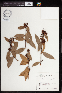 Cavendishia Lindl. 701925[1349674]Taylor, John 176591974-12-26 Costa Rica, Prov. Heredia; along the slopes of the Cerro Zurqui above the Rio Para Blanco., 10.021252 -84.012122, 1600m |
MIN:Plants | 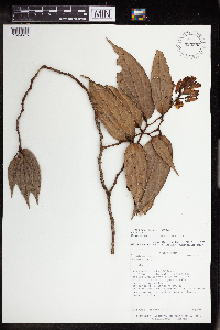 Cavendishia Lindl. 925583[1349675]Hererra, Gerardo 20761988-07-13 Costa Rica, Alajuela: Upala, Bijagua; El Pilon, de la interseccion del camino San Miguel a El Pilon con el Rio Chimurria, 10.725 -85.008333, 600m |
1
Page 1, records 1-2 of 2
Google Map
Google Maps is a web mapping service provided by Google that features a map that users can pan (by dragging the mouse) and zoom (by using the mouse wheel). Collection points are displayed as colored markers that when clicked on, displays the full information for that collection. When multiple species are queried (separated by semi-colons), different colored markers denote each individual species.