University of Minnesota
http://www.umn.edu/
612-625-5000
http://www.umn.edu/
612-625-5000
Minnesota Biodiversity Atlas
Bell Museum
Dataset: MIN-Plants
Taxa: Ranunculaceae
Search Criteria: excluding cultivated/captive occurrences
Bell Museum plants | |
 MIN:Plants |  951692[1299210]Weiblen, G.D. YS3F21152010-08-16 Papua New Guinea, Morobe, Yawan Village, -6.16255 146.839933, 1721m |
MIN:Plants |  112886[1374864]Newdeqate s.n. South Africa, In rupestribus clivris montinm prope Knysna, 27 - 305m |
MIN:Plants | Clematis NULL 939819[]Takeuchi, Wayne 74201991-08-18 Papua New Guinea, On the Gabensis road;;;;, -6.7 146.76666, 564m |
MIN:Plants | Delphinium NULL 479476[]Bright, R. 73-2611973-00-00 United States, Idaho, Franklin, [no further data] |
MIN:Plants |  961359[1334777] United States, Nebraska |
MIN:Plants |  961339[1334787] United States, Illinois |
MIN:Plants | 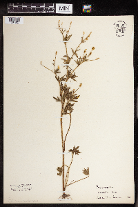 961299[1334827] United States, Wisconsin |
MIN:Plants | 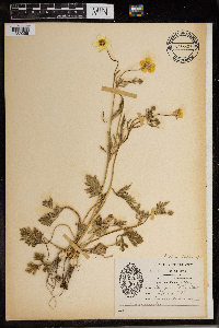 966483[1359258]Sister Saint Mark Wirtz United States, Minnesota, Ramsey, College of St.Catherine |
MIN:Plants |  113662[1374872]Wood, J. Medley 9551891-12-00 South Africa, Natal, summit of Drakensberg near Van Reenen's Pass, 1676m |
MIN:Plants |  972652[1398205]Janssens, J. 1081974-04-26 Belgium |
MIN:Plants |  951930[1290373]Lawrence, D. B. 691930-07-02 United States, Colorado, Gunnison, Gothic. Rocky Mountain Biological Station. |
MIN:Plants |  963351[1348225] United States, Washington, Mount Ranier National Park |
MIN:Plants | Delphinium polycladon Eastwood 238374[]Congdon, J. s.n.1890-08-21 United States, California, Mariposa, Yosemite Creek above Fall, Mariposa County;Yosemite National Park |
MIN:Plants | Delphinium polycladon Eastwood 551729[]Tucker, J. 33421957-09-05 United States, California, Inyo, Onion Valley, east side of Kearsarge Pass, in the high Sierra Nevada, Inyo County;Kings Canyon National Park, 2865m |
MIN:Plants | Delphinium polycladon Eastwood 237722[]Congdon, J. s.n.1891-07-22 United States, California, Mariposa, Elam Meadows, Glacier Point Turnpike, Mariposa County;Yosemite National Park |
MIN:Plants | Delphinium polycladon Eastwood 238113[]Congdon, J. s.n.1899-08-20 United States, California, Madera, Near Minarets, Madera County;Yosemite National Park |
MIN:Plants | Delphinium polycladon Eastwood 238195[]Congdon, J. s.n.1898-08-07 United States, California, Tuolumne, Cathedral Trail, Tuolumne County;Yosemite National Park |
MIN:Plants | Delphinium polycladon Eastwood 238193[]Congdon, J. s.n.1894-08-15 United States, California, Tuolumne, Tioga Road above Soda Springs, Tuolumne County;Yosemite National Park |
MIN:Plants | Cimicifuga racemosa (L.) Nuttall 387115[]Chrysler, M. s.n.1943-07-20 United States, New Jersey, Somerset, Somerset Co. ... First Watchung Mountain at Chimney Rock |
MIN:Plants | Cimicifuga racemosa (L.) Nuttall 479482[]US Nat. Arboretum staff 77-1581977-00-00 United States, New York, Dutchess, Dutchess Co. |
MIN:Plants | Cimicifuga racemosa (L.) Nuttall 479485[]US Nat. Arboretum staff 1491975-00-00 United States, District of Columbia, Washington |
MIN:Plants | Cimicifuga racemosa (L.) Nuttall 479424[]US Nat. Arboretum staff 1421974-00-00 United States, District of Columbia, Washington |
MIN:Plants | Delphinium barbeyi (Huth) Huth 112623[]Osterhout, George s.n.1893-08-00 United States, Colorado, Larimer, High Mts. Larimer Co.;Rocky Mountain National Park |
MIN:Plants | Delphinium barbeyi (Huth) Huth 580498[]Hunnewell, F. 20971913-07-11 United States, Colorado, Larimer, Estes Park, Larimer Co. ... Long's Peak;Rocky Mountain National Park |
MIN:Plants | Delphinium barbeyi (Huth) Huth 112638[]Anonymous 2691898-08-11 United States, Colorado, Larimer, Grays Peak.;Rocky Mountain National Park |
MIN:Plants | Delphinium barbeyi (Huth) Huth []Weiblen, G. D. GW13042001-07-30 United States, Colorado, Gunnison, 1.67 km W of cemetary on Kebler Pass Road, 38.833333 -107.083333, 2987m |
MIN:Plants | Anemone caroliniana Walter 110939[]Leiberg, John s.n.1883-00-00 United States, Minnesota, Blue Earth, [no further data];;;;, 44.132599 -94.002655 |
MIN:Plants | Anemone caroliniana Walter 110940[]Payne, F. s.n.1890-05-00 United States, Minnesota, Swift, Swift Co.;;N;;, 45.2667 -95.6667 |
MIN:Plants | Anemone caroliniana Walter 110941[]Sandberg, John s.n.1886-05-00 United States, Minnesota, Goodhue, Red Wing;;113N;14W;00, 44.562468 -92.533801 |
MIN:Plants | Anemone caroliniana Walter 109417[]Butters, F.; et al. 31921916-05-06 United States, Minnesota, Goodhue, Cannon Valley, 4 mi. E of Cannon Falls.;Dorer Memorial Hardwood State Forest;;;, 44.585648 -92.557156 |
MIN:Plants | Anemone caroliniana Walter 110942[]Moyer, Lycurgus s.n.1895-05-00 United States, Minnesota, Chippewa, Montevideo;;117N;40W;, 44.941389 -95.722222 |
MIN:Plants | Anemone caroliniana Walter 110943[]Sandberg, John s.n.1894-05-00 United States, Minnesota, Goodhue, Cannon Falls;;112N;17W;, 44.506911 -92.905484 |
MIN:Plants | Anemone caroliniana Walter 110944[]Sandberg, John s.n.1890-05-00 United States, Minnesota, Goodhue, Cannon Falls;;112N;17W;18, 44.50707 -92.90512 |
MIN:Plants | Anemone caroliniana Walter 110945[]Moyer, Lycurgus s.n.1894-05-00 United States, Minnesota, Chippewa, Montevideo.;;117N;40W;, 44.941389 -95.722222 |
MIN:Plants | Anemone caroliniana Walter 110946[]Nelson, Nels s.n.1894-05-00 United States, Minnesota, Chippewa, Montevideo;;117N;40W;, 44.941389 -95.722222 |
MIN:Plants | Anemone caroliniana Walter 110948[]Payne, F. s.n.1890-05-00 United States, Minnesota, Grant, Pomme de Terre.;;130N;42W;00, 46.065276 -95.954102 |
MIN:Plants | Anemone caroliniana Walter 110949[]Lakela, Olga s.n.1921-05-02 United States, Minnesota, Hennepin, On the banks of the Mississippi River, below the High Dam, Minneapolis.;;N;;, 44.989366 -93.269236 |
MIN:Plants | Anemone caroliniana Walter 110950[]Menzel, Max s.n.1896-04-00 United States, Minnesota, Pipestone, Pipestone [assuming the quarry area; town generally noted as Pipestone City by collector];Pipestone National Monument;106N;46W;01, 44.01585 -96.31767 |
MIN:Plants | Anemone caroliniana Walter 110951[]Anderson, A. An8891894-05-00 United States, Minnesota, Washington, Stillwater;;030N;20W;, 45.05199 -92.811877 |
MIN:Plants | Anemone caroliniana Walter 110952[]Moyer, Lycurgus 15691894-05-00 United States, Minnesota, Chippewa, Montevideo;;117N;40W;, 44.941389 -95.722222 |
MIN:Plants | Anemone caroliniana Walter 110953[]Aiton, G. s.n.1895-03-24 United States, Minnesota, Goodhue, Cannon Falls;;112N;17W;, 44.506911 -92.905484 |
MIN:Plants | Anemone caroliniana Walter 110954[]Moyer, Lycurgus 15691886-05-02 United States, Minnesota, Chippewa, N of of wagon road to Montevideo. 2 mi. SE of Montevideo.;;117N;40W;, 44.91614 -95.670603 |
MIN:Plants | Anemone caroliniana Walter 110955[]Sandberg, John s.n.1882-05-00 United States, Minnesota, Goodhue, Cannon Falls.;;112N;17W;18, 44.506911 -92.905484 |
MIN:Plants | Anemone caroliniana Walter 110956[]Menzel, Max S16021891-06-00 United States, Minnesota, Pipestone, Pipestone [assuming the quarry area; town generally noted as Pipestone City by collector];Pipestone National Monument;106N;46W;01, 44.01585 -96.31767 |
MIN:Plants | Anemone caroliniana Walter 264100[]Anonymous s.n.1901-05-00 United States, Minnesota, Dakota, Farm area near Hastings.;;N;;, 44.674494 -92.8538 |
MIN:Plants | Anemone caroliniana Walter 295917[]Daggy, Richard s.n.1935-05-13 United States, Minnesota, Washington, Gray Cloud Island. Ramsey Co. [should be Washington Co.];;;;, 44.794667 -92.978442 |
MIN:Plants | Anemone caroliniana Walter 349151[]Rosendahl, C.; et al. 30451935-06-23 United States, Minnesota, Pipestone, Near Pipestone. Pipestone Co.;;106N;46W;, 44.000526 -96.317534 |
MIN:Plants | Anemone caroliniana Walter 349152[]Rosendahl, C.; et al. 30501935-06-23 United States, Minnesota, Pipestone, Near Pipestone. 2nd quartzite outcrop [at the Monument?];Pipestone National Monument;106N;46W;, 44.013519 -96.324755 |
MIN:Plants | Anemone caroliniana Walter 349155[]Rosendahl, C.; et al. 30511935-06-23 United States, Minnesota, Pipestone, Near Pipestone. 2nd quartzite outcrop [possibly at the Monument?];Pipestone National Monument;106N;46W;, 44.013519 -96.324755 |
MIN:Plants | Anemone caroliniana Walter 352425[]Rosendahl, C.; et al. 30141935-05-19 United States, Minnesota, Pipestone, Pipestone quarries, Pipestone.;Pipestone National Monument;106N;46W;, 44.013519 -96.324755 |
MIN:Plants | Anemone caroliniana Walter 421344[]Jacobs, D. 4301948-04-29 United States, Minnesota, Nicollet, Schloeman Farm, across the river from Judson.;;T109N R28W;, 44.196354 -94.195239 |
MIN:Plants | Anemone caroliniana Walter 436978[]Moore, John; Barnum, B. 162051944-05-22 United States, Minnesota, Washington, 1.5 mi s of Bayport.;;029N;20W;, 44.981454 -92.826658 |
MIN:Plants | Anemone caroliniana Walter 497051[]Lawrence, Donald s.n.1954-05-15 United States, Minnesota, Rock, N of the mounds, 2 1/2 mi. NE of Luverne.;;N;;, 43.679736 -96.177417 |
MIN:Plants | Anemone caroliniana Walter 602179[]Westkaemper, Remberta s.n.1966-05-00 United States, Minnesota, Stearns, Stearns Co. Cold Spring;;123N;30W;, 45.454397 -94.422475 |
MIN:Plants | Anemone caroliniana Walter 604732[]Dahl, A. s.n.1937-05-12 United States, Minnesota, Scott, Belle Plaine;;N;;, 44.589637 -93.716839 |
MIN:Plants | Anemone caroliniana Walter 673647[]Borchard, Alma s.n.1939-05-13 United States, Minnesota, Washington, Washington Co.; Mississippi River across from Hastings;;026N;20W;, 44.753721 -92.855704 |
MIN:Plants | Anemone caroliniana Walter 700576[]Mason, Harriet; et al. s.n.1979-05-28 United States, Minnesota, Le Sueur, Le Sueur Co. T109N, R26W, Sec. 6, NE1/4 of SE1/4;East Minnesota River Wildlife Management Area;109N;26W;06, 44.274575 -93.998475 |
MIN:Plants | Anemone caroliniana Walter 743590[]Nietering, E.; et al. 471982-05-08 United States, Minnesota, Redwood, Redwood County...SW1/4 SE1/4 Sec. 17, R37W, T114N. N of Belview.;;114N;37W;17, 44.679459 -95.329739 |
MIN:Plants | Anemone caroliniana Walter 743591[]Nietering, E. 381982-05-03 United States, Minnesota, Chippewa, Chippewa Co. NW1/4 NE1/4 Sec. 14, R39W, T115N. SE of Granite Falls.;;115N;39W;14, 44.771035 -95.513539 |
MIN:Plants | Anemone caroliniana Walter 743592[]Nietering, E.; et al. 221982-05-02 United States, Minnesota, Renville, Renville County...Morton Outcrop (60). NW1/4 NW1/4 Sec. 31, R35W, T113N.;;113N;35W;31, 44.55135 -94.984439 |
MIN:Plants | Anemone caroliniana Walter 743650[]Nietering, E. 1851982-05-02 United States, Minnesota, Renville, Renville Co. Along CR 15, ca. 1/4 mi. from intersection with CR 1. NE1/4 SE1/4 Sec. 20, R35W, T113N. N of North Redwoo Renville Co. Along CR 15, ca. 1/4 mi. from intersection with CR 1. NE1/4 SE1/4 Sec. 20, R35W, T113N. N of North Redwood.. 113N 35W 20, 44.578346 -95.085406 |
MIN:Plants | Anemone caroliniana Walter 743651[]Nietering, E. 521982-05-11 United States, Minnesota, Redwood, Redwood Co. SE1/4 SE1/4 Sec. 28, R35W, T113N. E of North Redwood.;;113N;35W;28, 44.56255 -95.066885 |
MIN:Plants | Anemone caroliniana Walter 743652[]Nietering, E.; et al. 231982-05-02 United States, Minnesota, Renville, Renville County...Morton Outcrop (60). NW1/4 NW1/4 Sec. 31, R35W, T113N.;;113N;35W;31, 44.55135 -94.984439 |
MIN:Plants | Anemone caroliniana Walter 743999[]Ownbey, Gerald 67531982-06-12 United States, Minnesota, Renville, Renville Co. NW of Morton. T113N, R34W, Sec. 31 NW1/4.;;113N;34W;31, 44.549251 -94.983808 |
MIN:Plants | Anemone caroliniana Walter 746960[]Jordan, s.n.1910-05-00 United States, Minnesota, Stearns, Stearns Co.; St. Cloud;;N;;, 45.557693 -94.1603 |
MIN:Plants | Anemone caroliniana Walter 751012[]Galatowitsch, S. 8501983-05-22 United States, Minnesota, Wabasha, Wabasha County...NW1/4 NE1/4 Sec. 6, T109N, R09W.;Kellogg-Weaver Dunes Scientific Natural Area / Kellogg-Weaver Dunes, The Nature Conservancy;109N;09W;06, 44.272608 -91.938982 |
MIN:Plants | Anemone caroliniana Walter 770043[]Smith, Welby 77931983-06-04 United States, Minnesota, Wabasha, Kellogg-Weaver Dunes Scientific Natural Area / Kellogg-Weaver Dunes, The Nature Conservancy. Kellogg-Weaver Dunes State Scientific and Natural Area. Ca. 4 mi. SE of Kellogg, on the E side of Co. Rd. 84. NW1/4 NE Kellogg-Weaver Dunes State Scientific and Natural Area. Ca. 4 mi. SE of Kellogg, on the E side of Co. Rd. 84. NW1/4 NE1/4 Sec. 6, T109N, R9W.. 109N 09W 6, 44.272608 -91.938982 |
MIN:Plants | Anemone caroliniana Walter 770313[]Smith, Welby 76561983-05-18 United States, Minnesota, Wabasha, Kellogg-Weaver Dunes Scientific Natural Area / Kellogg-Weaver Dunes, The Nature Conservancy. Kellogg-Weaver Dunes State Scientific and Natural Area. Ca. 4 mi. SE of Kellogg, on the E side of Co. Rd. 84. SE1/4 NE Kellogg-Weaver Dunes State Scientific and Natural Area. Ca. 4 mi. SE of Kellogg, on the E side of Co. Rd. 84. SE1/4 NE1/4 Sec. 6, T109N, R09W.. 109N 09W , 44.272608 -91.938982 |
MIN:Plants | Anemone caroliniana Walter 780504[]Ownbey, Gerald 68771983-05-11 United States, Minnesota, Washington, Saint Croix Savanna Scientific Natural Area. T29W, R20W, Sec. 15, NE1/4. Along Rte. 95, 3 mi. N of its jct. with I94. High sand and gravel ridge paralleling Rte. 9 T29W, R20W, Sec. 15, NE1/4. Along Rte. 95, 3 mi. N of its jct. with I94. High sand and gravel ridge paralleling Rte. 95, W side.. 029N 20W 15, 45.003221 -92.786674 |
MIN:Plants | Anemone caroliniana Walter 792852[]Converse, C. 23561983-06-10 United States, Minnesota, Dakota, Dakota Co. SE1/4 NW1/4 Sec. 11, T114N, R17W.;;114N;17W;11, 44.696698 -92.825497 |
MIN:Plants | Anemone caroliniana Walter 792853[]Converse, C. 23581983-06-10 United States, Minnesota, Dakota, Dakota Co. SE1/4 NW1/4 Sec. 11, T114N, R17W.;;114N;17W;11, 44.696698 -92.825497 |
MIN:Plants | Anemone caroliniana Walter 499566[]Anonymous s.n.1876-05-10 United States, Minnesota, Washington, Afton;;028N;20W;, 44.897646 -92.791138 |
MIN:Plants | Anemone caroliniana Walter 944930[]Dziuk, Peter M. PMD15-0272015-04-27 United States, Minnesota, Dakota, Hastings. East side of Red Wing Blvd. 1.72 miles south of junction off 61, north and south of sides of private driveway. T114N, T17W, Sec 11, 44.700178 -92.825981 |
MIN:Plants |  Anemone caroliniana Walter 962529[1346910]Putnam, Mary P. s. n.1906-06-19 United States, Minnesota, Stearns |
MIN:Plants |  Anemone caroliniana Walter 0968815[1391413]Jensen, M. s.n.1938-00-00 United States, Texas |
MIN:Plants | Ranunculus pensylvanicus L. f. 904643[]Lee, Michael MDL40472005-07-27 United States, Minnesota, Becker, White Earth Indian Reservation. Becker County...moarine east of Many Point Lake, 9.5 miles north-northwest of Ponsford...Back of the Moon Lake... T142N R38W NE1/4 of NE1/4 Sec. 27. 142N 38W 27, 47.09248 -95.468111 |
MIN:Plants | Ranunculus pensylvanicus L. f. 474298[]Dana, R.; Biederman, L. RPD 990101999-07-01 United States, Minnesota, Dodge, Iron Horse Prairie Scientific Natural Area. Dodge Co.; Iron Horse Prairie Scientific and Natural Area. ... Coll. in releve plot DNR-7906. T105N R17W NW1/4 SE1/4 Sec. 27. 105N 17W 27, 43.8666649 -92.8499985 |
MIN:Plants | Ranunculus pensylvanicus L. f. 910733[]Smith, Welby 247071994-07-13 United States, Minnesota, Polk, Polk County...About 5 miles southwest of Erskine...T 148N R43W NE1/4 of NW1/4 of Sec 25;;148N;43W;25, 47.6094444 -96.0797222 |
MIN:Plants | Ranunculus pensylvanicus L. f. 904368[]Gerdes, Lynden 54692007-07-05 United States, Minnesota, Lake, Superior National Forest. T60N R09W S26 NWSW Lake County ...Superior National Forest. West Fish Fry Lake area, approximately 5.05 miles NW of Isabella, MN ... ('Slash Pond') 0.15 miles north of West Fish Fry Lake ... NAD 83 / 616479 / 5278668. 060N 09W 26, 47.6508333 -91.4488889 |
MIN:Plants | Ranunculus pensylvanicus L. f. 914572[]Smith, Welby 250431994-08-09 United States, Minnesota, Pine, Pine County...Black Lake Bog State Scientific and Natural Area...T 45N R16W SE1/4 of SW1/4 of Sec 25;Black Lake Bog Scientific Natural Area;045N;16W;25, 46.3477778 -92.3111111 |
MIN:Plants | Ranunculus pensylvanicus L. f. 510406[]Gerdes, Lynden; et al. 27951998-07-01 United States, Minnesota, Cook, T65N R01E S27NENW. Cook County ... Superior National Forest, BWCAW. Shores of Clearwater Lake; north side of lake.;Boundary Waters Canoe Area Wilderness / Superior National Forest;065N;01E;27, 48.083795 -90.312959 |
MIN:Plants | Ranunculus pensylvanicus L. f. 480685[]Gerdes, Lynden 28571998-06-06 United States, Minnesota, Cook, Boundary Waters Canoe Area Wilderness / Superior National Forest. Cook County ... Superior National Forest, BWCAW. Wetland coplex ~.25 miles NE of the far NE corner of West Pike Lake, T65N R02E S26SWNW. T065N R02E S26, 48.085574 -90.154825 |
MIN:Plants | Ranunculus pensylvanicus L. f. 510933[]Gerdes, Lynden; et al. 28571998-07-06 United States, Minnesota, Cook, T65N R02E S26SWNW. Cook County ... Superior National Forest, BWCAW ... ~.25 miles NE of the far NE corner of West Pike L;Boundary Waters Canoe Area Wilderness / Superior National Forest;065N;02E;26, 48.085574 -90.154825 |
MIN:Plants | Ranunculus pensylvanicus L. f. 910929[]Smith, Welby 219671992-09-07 United States, Minnesota, Watonwan, Eagle Nest County Park. Watonwan County...In Eagle Nest County Park, about 5 miles east of St. James...along the South Fork Watonwan River... T 106N R 31W NE1/4 of NE1/4 of Sec 14. 106N 31W 14, 43.9925 -94.5097222 |
MIN:Plants | Ranunculus pensylvanicus L. f. 510912[]Gerdes, Lynden; et al. 28451998-07-05 United States, Minnesota, Cook, T65N R02E S28SWNWSW. Cook County ... Superior National Forest, BWCAW ... just south of the south shore of West Pike Lake;Boundary Waters Canoe Area Wilderness / Superior National Forest;065N;02E;26, 48.085457 -90.198929 |
MIN:Plants | Ranunculus pensylvanicus L. f. 913994[]Smith, Welby 227241993-07-02 United States, Minnesota, Becker, Becker County...About 2.5 miles east of White Earth...T 142N R 40W NW1/4 of NW1/4 of sec 29;White Earth Indian Reservation;142N;40W;29, 47.0897222 -95.7816667 |
MIN:Plants | Ranunculus pensylvanicus L. f. 920906[]Smith, Welby 173501990-07-18 United States, Minnesota, Morrison, Camp Ripley Military Reservation. Camp Ripley Military Reservation. Morrison County...On the east side of Luzon Road...Goose Pond... UTM: 389600E 5108500N. T 131N R 30W NW1/4 of NW1/4 of Sec 35. 131N 30W 35, 46.1230556 -94.4288889 |
MIN:Plants | Ranunculus pensylvanicus L. f. 432688[]Gerdes, Lynden 37201999-08-03 United States, Minnesota, Cook, T64N R01W S02SE. Cook County...Superior National Forest, Flour Lake public boat access area.;Superior National Forest;064N;01W;02, 48.055879 -90.415017 |
MIN:Plants | Ranunculus pensylvanicus L. f. 907676[]Lee, Michael; et al. MDL38292004-08-24 United States, Minnesota, Todd, Along the Long Prairie River, five miles north-northeast of Browerville. W1/2 of NE1/4 of NE1/4 Sec.;;131N;33W;22, 46.158563 -94.86094 |
MIN:Plants | Ranunculus pensylvanicus L. f. 913937[]Smith, Welby 254961994-09-13 United States, Minnesota, Murray, Lake Shetek State Park. Murray County ... Lake Shetek State Park, about 3 miles northwest of Currie ... shore of Lake Shetek ... T107N R40W SW1/4 of SW1/4 of Sec 31. 107N 40W 31, 44.1111111 -95.7011111 |
MIN:Plants | Ranunculus pensylvanicus L. f. 920816[]Smith, Welby 176301990-08-01 United States, Minnesota, Morrison, Camp Ripley Military Reservation. Camp Ripley Military Reservation. Morrison County...About 0.5 km west of Kodiak Road and 1.0 km east of Lake... Alexandeer...UTM: 385000E 5117000N. T 131N R 30W NE1/4 of SW1/4 of Sec 32. 131N 30W 32, 46.1988889 -94.4905556 |
MIN:Plants | Ranunculus pensylvanicus L. f. 479950[]US Nat. Arboretum staff s.n.1981-00-00 United States, Minnesota, Crow Wing, Crow Wing Co.;;;;, 46.482372 -94.070879 |
MIN:Plants | Ranunculus pensylvanicus L. f. 114080[]Moyer, Lycurgus 16171903-08-00 United States, Minnesota, Chippewa, Montevideo;;117N;40W;, 44.941389 -95.722222 |
MIN:Plants | Ranunculus pensylvanicus L. f. 114290[]MacMillan, C.; et al. 6131894-06-26 United States, Minnesota, Lake of the Woods, Garden Island, Lake of the Woods;Northwest Angle;166N;33W;00, 49.19326 -94.89383 |
MIN:Plants | Ranunculus pensylvanicus L. f. 114291[]G. & L. 16161885-08-02 United States, Minnesota, Chippewa, Montevideo;;117N;40W;, 44.941389 -95.722222 |
MIN:Plants | Ranunculus pensylvanicus L. f. 114292[]Manning, Sara s.n.1883-08-15 United States, Minnesota, Wabasha, Lake City;;N;;, 44.449412 -92.266844 |
MIN:Plants | Ranunculus pensylvanicus L. f. 114294[]Arthur, J.; et al. B711886-07-19 United States, Minnesota, Saint Louis, Vermilion Lake;;;;, 47.89167 -92.36667 |
MIN:Plants | Ranunculus pensylvanicus L. f. 114295[]Butters, F.; et al. 36331918-07-17 United States, Minnesota, Anoka, Moore Lake;;030N;24W;, 45.07639 -93.2475 |
MIN:Plants | Ranunculus pensylvanicus L. f. 114296[]Ballard, C. 26421900-08-00 United States, Minnesota, Kittson, St. Vincent;;163N;51W;, 48.9667 -97.2167 |
MIN:Plants | Ranunculus pensylvanicus L. f. 114297[]Ballard, C. 27561900-08-00 United States, Minnesota, Kittson, Hallock;;161N;49W;, 48.76042 -96.99613 |
Google Map
Google Maps is a web mapping service provided by Google that features a map that users can pan (by dragging the mouse) and zoom (by using the mouse wheel). Collection points are displayed as colored markers that when clicked on, displays the full information for that collection. When multiple species are queried (separated by semi-colons), different colored markers denote each individual species.