University of Minnesota
http://www.umn.edu/
612-625-5000
http://www.umn.edu/
612-625-5000
Minnesota Biodiversity Atlas
Bell Museum
Dataset: MIN-Plants
Taxa: Simaroubaceae
Search Criteria: excluding cultivated/captive occurrences
1
Page 1, records 1-10 of 10
Bell Museum plants | |
 MIN:Plants | Ailanthus altissima (Miller) Swingle 146438[]Lucy, T. 14961897-06-27 United States, New York, Chemung, Upper Waters of the Susquehanna [River] |
MIN:Plants | 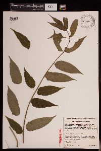 Ailanthus altissima (Miller) Swingle 951883[1290167]Gernes, Carole J. 62013-06-13 United States, Minnesota, Ramsey, City of St. Paul. In an area surrounded by building, retaining wall and sidewalk; west side of former Affinity Plus Credit Union, NE of intersection of Park St. and Sherburne Ave; one block north of University Ave, 44.9572 -93.1036 |
MIN:Plants | Leitneria floridana Chapman 569364[]US Nat. Arboretum staff 1091974-00-00 United States, District of Columbia, USNA [Nat. Arboretum] -- cult. |
MIN:Plants | Simarouba amara NULL 939765[]P 782011-07-07 Costa Rica, Guanacaste, Liberia, , 10.84 -85.61, 320m |
MIN:Plants | 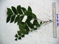 923577[]Whitfeld, T.J.S. OB2A01272008-07-26 Papua New Guinea, Madang, Wanang Village, -5.229433 145.173667, 188m |
MIN:Plants | 921335[]Whitfeld, T.J.S. OC1E00492008-07-31 Papua New Guinea, Madang, Wanang Village, -5.2319 145.155767, 218m |
MIN:Plants | 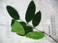 920716[]Whitfeld, T.J.S. PA2A01132008-08-13 Papua New Guinea, Madang, Wanang Village, -5.237483 145.115733, 129m |
MIN:Plants | 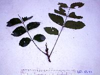 916805[]Weiblen, G.D. & Binatang Research Center WP1B00732006-03-21 Papua New Guinea, Madang, Wanang Village, -5.2373 145.177183, 115m |
MIN:Plants |  Picrasma javanica Blume 920696[]Whitfeld, T.J.S. OC1E00402008-07-31 Papua New Guinea, Madang, Wanang Village, -5.2319 145.155767, 218m |
MIN:Plants |  Picrasma javanica Blume 970221[1371822]Weiblen, G. D. & Binatang Research Center NP4A21262013-07-25 Papua New Guinea, Madang, Numba, -5.7222 145.2714, 1200m |
1
Page 1, records 1-10 of 10
Google Map
Google Maps is a web mapping service provided by Google that features a map that users can pan (by dragging the mouse) and zoom (by using the mouse wheel). Collection points are displayed as colored markers that when clicked on, displays the full information for that collection. When multiple species are queried (separated by semi-colons), different colored markers denote each individual species.