University of Minnesota
http://www.umn.edu/
612-625-5000
http://www.umn.edu/
612-625-5000
Minnesota Biodiversity Atlas
Bell Museum
Dataset: MIN-Plants
Taxa: Sparganiaceae
Search Criteria: excluding cultivated/captive occurrences
Bell Museum plants | |
 MIN:Plants |  Sparganium NULL 427206[1145487]Myhre, K. 28151992-07-23 United States, Minnesota, Cass, Southwest shore of Cedar Lake. SW1/4 of SW1/4 of section;Chippewa National Forest / Leech Lake Indian Reservation;141N;29W;14, 47.025179 -94.325085 |
MIN:Plants |  Sparganium NULL 445261[1145489]Myhre, K. 59371995-07-25 United States, Minnesota, Mahnomen, 7 miles southwest of the town of Nay-tah-waush; north shore of McCraney Lake. SW1/4 of NW1/4 of section;White Earth Indian Reservation / White Earth State Forest;143N;40W;25, 47.228302 -95.938953 |
MIN:Plants |  Sparganium NULL 362051[1145486]Moyle, J. 34321940-08-10 United States, Minnesota, Lake, Nine Mile Creek. Manitou River System.;Superior National Forest;;;, 47.443058 -91.063907 |
MIN:Plants |  Sparganium NULL 532661[1145490]Lakela, Olga; Elwell, M. 206841956-08-07 United States, Minnesota, Saint Louis, Bullet Lake, north of Ely;Boundary Waters Canoe Area Wilderness / Superior National Forest;065N;12W;12, 48.126307 -91.796631 |
MIN:Plants |  Sparganium NULL 429740[1145488]Myhre, K. 68931997-07-10 United States, Minnesota, Carlton, Eagle Lake. Located two miles southwest of the town of Cromwell; northeast end of the lake. NE1/4 of NW1/4 of section.;;048N;20W;17, 46.644264 -92.917206 |
MIN:Plants |  Sparganium NULL 56990[1189370] |
MIN:Plants | 965942[1356701] 1947-08-09 United States, Minnesota |
MIN:Plants |  Sparganium eurycarpum Engelmann 896526[1145926]Smith, Welby 156941989-07-13 United States, Minnesota, Kanabec, Kanabek [sic] County...Along the north side of Mud Lake (Quamba Lake), about one mile south of Quamba...NW1/4 NE1/4 section 2, T 39N R 23W. 039N 23W 2, 45.90377 -93.170582 |
MIN:Plants |  Sparganium eurycarpum Engelmann 910455[1145945]Perleberg, D.; Loso, Stephanie 13782006-07-20 United States, Minnesota, Cass, Lake ID: 11041200, Birch Lake. In the channel between upper birch and lower birch, DNR Site # 754. [collector provided invalid lat/long];Foothills State Forest;140N;31W;13, 46.938473 -94.545107 |
MIN:Plants |  Sparganium eurycarpum Engelmann 917057[1145898]Lee, Michael MDL40572005-07-28 United States, Minnesota, Becker, White Earth Indian Reservation. Becker County...Many Point Boy Scout Camp. at tip of long, narrow peninsula into the southwest side of Many Point Lake, ten miles northwest of Ponsford...T142N R38W NW1/4 of SW1/4 of NE1/4 Sec. 31. 142N 38W 31, 47.073869 -95.539243 |
MIN:Plants |  Sparganium eurycarpum Engelmann 428067[1145855]Mensing, D. 95-21021995-08-31 United States, Minnesota, Chisago, Chisago Co, T37N R22W NE1/4 of the SW1/4 of S21; Bird Island located in west arm of Rush Lake;Rush Lake Island Scientific Natural Area;037N;22W;21, 45.674559 -93.09571 |
MIN:Plants |  Sparganium eurycarpum Engelmann 477623[1145960]Myhre, K. 68011997-07-02 United States, Minnesota, Carlton, Carlton County ... Tamarack Lake. Located one mile south of the town of Wright ... T48N R21W NW1/4 of SE1/4 of Sec 9;;048N;21W;09, 46.656698 -93.008867 |
MIN:Plants |  Sparganium eurycarpum Engelmann 912776[1145928]Lee, Michael; Johnson, Jason MDL44612007-07-25 United States, Minnesota, Hubbard, Crow Wing River just downstream from the mouth of the Shell River, just north of the Wadena County line, two miles north of Huntersville. UTM: 5185401N 356075E. W1/2 SW1/4 SE1/4 of sec.;Crow Wing Chain Wildlife Management Area;139N;33W;32, 46.8066069 -94.8863383 |
MIN:Plants |  Sparganium eurycarpum Engelmann 908341[1145947]Smith, Welby 311052008-08-13 United States, Minnesota, Le Sueur, Murphy Wildlife Management Area [Le Sueur County]. Le Sueur County...Murphy State Wildlife Management Area, about 4 miles northwest of Waterville...T 109N R 23W SE1/4 of SW1/4 of sec 5. 109N 23W 5, 44.2713889 -93.6197222 |
MIN:Plants |  Sparganium eurycarpum Engelmann 505675[1145880]Gerdes, Lynden; Gerdes, D. Lawson 28971998-07-09 United States, Minnesota, Cook, South west shore of John Lake; north & west of narrows between John Lake and Little John Lake. NWNW of sec.;Boundary Waters Canoe Area Wilderness / Superior National Forest;064N;03E;03, 48.063612 -90.046985 |
MIN:Plants |  Sparganium eurycarpum Engelmann 499370[1145944]Capistrant, A. AMC13881998-07-28 United States, Minnesota, McLeod, McLeod Co, T115N R29W S34;Schaefer Prairie, The Nature Conservancy;115N;29W;34, 44.724106 -94.305158 |
MIN:Plants |  Sparganium eurycarpum Engelmann 479153[1145840]Mensing, D. 95-571995-09-08 United States, Minnesota, Chisago, Chisago Co, T36N R20W SE1/4 of the NW1/4 of S30; Goose Creek;Wild River State Park;036N;20W;30, 45.58077 -92.891622 |
MIN:Plants |  Sparganium eurycarpum Engelmann 906385[1145912]Lee, Michael MDL37142004-07-20 United States, Minnesota, Todd, Todd County...Pine Island Lake, 6-1/2 miles west-southwest of Cushing, and 8 miles east-northeast of Browerville... T131N R32W SW1/4 of NE1/4 Sec. 33. 131N 32W 33, 46.11486 -94.720817 |
MIN:Plants |  Sparganium eurycarpum Engelmann 432487[1145799]Lee, Michael; Lee, Brittany MDL22451998-07-16 United States, Minnesota, Stearns, 1.5 miles south-southeast of Sauk Centre. Sauk River. SW1/4 of SE1/4 of section;Sauk River Wildlife Management Area;126N;34W;22, 45.740151 -94.952418 |
MIN:Plants |  Sparganium eurycarpum Engelmann 479546[1145881]Lee, Michael; Zager, S. MDL23171998-07-29 United States, Minnesota, Crow Wing, Little Pine River eight miles south-southwest of Emily. SE1/4 of SW1/4 of sec.;;136N;26W;05, 46.619152 -94.11416 |
MIN:Plants |  Sparganium eurycarpum Engelmann 440644[1145923]DeMink, L. 3892000-09-18 United States, Minnesota, Morrison, Crane Meadows National Wildlife Refuge; NENE 30-T40N-R31W; Rice Lake;Crane Meadows National Wildlife Refuge;040N;31W;30, 45.933896 -94.251565 |
MIN:Plants |  Sparganium eurycarpum Engelmann 107379[1145935]Taylor, B. T11091891-08-00 United States, Minnesota, Pope, Glenwood;;125N;37W;07, 45.648982 -95.401248 |
MIN:Plants |  Sparganium eurycarpum Engelmann 263733[1145917]Nurnberger, P. P28291928-08-10 United States, Minnesota, Aitkin, Big Sandy Lake;Savanna State Forest;N;;, 46.760517 -93.287213 |
MIN:Plants |  Sparganium eurycarpum Engelmann 264298[1145861]Holzinger, John s.n.1900-08-00 United States, Minnesota, Winona, Mississippi River sloughs, opposite Winona.;;N;;, 44.037463 -91.687677 |
MIN:Plants |  Sparganium eurycarpum Engelmann 265522[1145869]Goldsmith, G. EG3291912-00-00 United States, Minnesota, Rice, Northfield;;N;;, 44.458298 -93.161604 |
MIN:Plants |  Sparganium eurycarpum Engelmann 270018[1145893]Taylor, B. T5221891-06-00 United States, Minnesota, Blue earth, Mud Lake;;N;;, 44.167945 -93.817238 |
MIN:Plants |  Sparganium eurycarpum Engelmann 275833[1145955]Grant, Martin 29601929-07-30 United States, Minnesota, Clearwater, Itasca Park. Schoolcraft Island. NE-NW-11, T143, R36.;Itasca State Park;143N;36W;11, 47.218013 -95.200853 |
MIN:Plants |  Sparganium eurycarpum Engelmann 276823[1145884]Huff, N. 2461914-08-29 United States, Minnesota, Lake, Lake Isabella;;N;;, 47.809224 -91.286733 |
MIN:Plants |  Sparganium eurycarpum Engelmann 277654[1145822]Hotchkiss, N.; et al. 2771930-07-07 United States, Minnesota, Hennepin, Halsted Bay, Lake Minnetonka.;;;;, 44.913869 -93.68907 |
MIN:Plants |  Sparganium eurycarpum Engelmann 297949[1145811]Nurnberger, P. 29131929-07-19 United States, Minnesota, Clearwater, Clearwater River.;;N;;, 47.577653 -95.379024 |
MIN:Plants |  Sparganium eurycarpum Engelmann 306560[1145819]Oosting, H. 30521930-08-23 United States, Minnesota, Hennepin, Lake Minnetonka - Navarre.;;117N;23W;, 44.915692 -93.617487 |
MIN:Plants |  Sparganium eurycarpum Engelmann 307306[1145934]Grant, Martin 67631935-09-05 United States, Minnesota, Clearwater, Itasca Park, Floating Boy Bog, SE-NE-11, T143, R36.;Itasca State Park;143N;36W;11, 47.218013 -95.200853 |
MIN:Plants |  Sparganium eurycarpum Engelmann 336389[1145848]Smith, L. 2511936-08-14 United States, Minnesota, Itasca, Marcell, Maple Lake, T60, R27.;Chippewa National Forest;060N;27W;, 47.64748 -93.722135 |
MIN:Plants |  Sparganium eurycarpum Engelmann 338053[1145828]Smith, L. 2531936-08-14 United States, Minnesota, Itasca, Marcell, Maple Lake;;N;;, 47.64748 -93.722135 |
MIN:Plants |  Sparganium eurycarpum Engelmann 345386[1145941]Lakela, Olga 20611937-07-13 United States, Minnesota, Saint Louis, Bayside of Minnesota Avenue between 20th and 21st Streets, Duluth.;;N;;, 46.7833 -92.1 |
MIN:Plants |  Sparganium eurycarpum Engelmann 350177[1145932]McCartney, James 541938-06-28 United States, Minnesota, Scott, Minn River between S.t.h. [highway] #50 and Savage.;;;;, 44.782177 -93.339598 |
MIN:Plants |  Sparganium eurycarpum Engelmann 350847[1145821]Hedman, H. 491938-07-00 United States, Minnesota, Hennepin, N Shore Brown's Bay, L. Minnetonka.;;N;;, 44.954978 -93.545517 |
MIN:Plants |  Sparganium eurycarpum Engelmann 351921[1145891]Nielsen, E. 251929-07-08 United States, Minnesota, Cass, Strawberry Point, Cass Lake;;N;;, 47.419288 -94.536519 |
MIN:Plants |  Sparganium eurycarpum Engelmann 354259[1145835]Moyle, J. 14871934-07-18 United States, Minnesota, Pennington, Along Thief River, Thief River Falls.;;N;;, 48.137191 -96.175395 |
MIN:Plants |  Sparganium eurycarpum Engelmann 360699[1145957]Butters, F.; et al. 65581934-09-06 United States, Minnesota, Aitkin, Farm Island Lake;;;;, 46.422051 -93.772021 |
MIN:Plants |  Sparganium eurycarpum Engelmann 362610[1145864]Lakela, Olga 37641940-07-20 United States, Minnesota, Saint Louis, Along the Minnesota River at Fond du Lac.;;N;;, 46.659664 -92.273248 |
MIN:Plants | 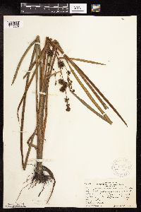 Sparganium eurycarpum Engelmann 370955[1145879]Rosendahl, C.; Moore, John 133571940-06-28 United States, Minnesota, Chippewa, 1/4 mi E of Montevideo.;;117N;40W;, 44.942457 -95.718522 |
MIN:Plants | 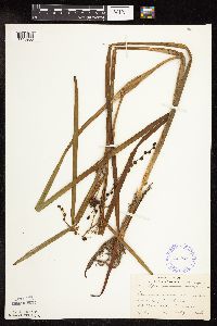 Sparganium eurycarpum Engelmann 385824[1145953]Lakela, Olga 55821944-07-02 United States, Minnesota, Saint Louis, Sturgeon River, 25 mi N of Hibbing;;N;;, 47.789032 -92.937689 |
MIN:Plants | 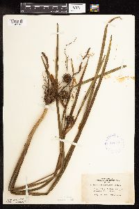 Sparganium eurycarpum Engelmann 407551[1145915]Lakela, Olga 91351949-07-29 United States, Minnesota, Saint Louis, Prairie Lake, SW St. Louis Co.;;050N;20W;, 46.79124 -92.904888 |
MIN:Plants | 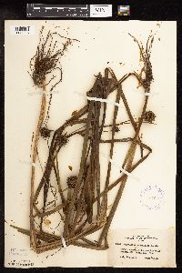 Sparganium eurycarpum Engelmann 407632[1145916]Lakela, Olga 89481949-07-14 United States, Minnesota, Saint Louis, Shagawa River at Winton.;;N;;, 47.927209 -91.808248 |
MIN:Plants |  Sparganium eurycarpum Engelmann 412083[1145914]Moore, John; Moore, Marjorie 109921939-07-20 United States, Minnesota, Lake of the Woods, W of mouth of Pine Creek, Angle Inlet.;Northwest Angle;168N;34W;, 49.353711 -95.002845 |
MIN:Plants |  Sparganium eurycarpum Engelmann 412822[1145913]Moore, John; Moore, Marjorie 115111939-08-07 United States, Minnesota, Kittson, Creek 1 mi S of Noyes.;;N;;, 48.983016 -97.204507 |
MIN:Plants |  Sparganium eurycarpum Engelmann 419675[1145907]Lakela, Olga 110401950-08-02 United States, Minnesota, Saint Louis, Lake S of Gilbert.;;N;;, 47.488816 -92.464905 |
MIN:Plants |  Sparganium eurycarpum Engelmann 425834[1145871]Emanuel, J. 5011951-06-27 United States, Minnesota, Winona, Just W of Prairie Is. bridge in city of Winona.;;107N;07W;, 44.052587 -91.6726869 |
MIN:Plants |  Sparganium eurycarpum Engelmann 426964[1145901]Myhre, K. 26831992-07-13 United States, Minnesota, Cass, Cass Co. Located along the S bank of the Shingobee River; T141N R31W NW1/4 of SW1/4 of Sec 15.;Chippewa National Forest;141N;31W;15, 47.030713 -94.594347 |
MIN:Plants |  Sparganium eurycarpum Engelmann 427370[1145903]Myhre, K. 25291992-07-02 United States, Minnesota, Cass, Cass Co. Located on the N bank of the Shingobee River; T141N R31W SW1/4 of NE1/4 of Sec 16;Chippewa National Forest;141N;31W;16, 47.034082 -94.605753 |
MIN:Plants |  Sparganium eurycarpum Engelmann 428389[1145902]Myhre, K. 27131992-07-14 United States, Minnesota, Cass, Cass Co. Located 1/4 mi N of Cub Lake; small lake; T141N R30W SW1/4 of NW1/4 of Sec 34;Chippewa National Forest;141N;30W;34, 46.988969 -94.467951 |
MIN:Plants |  Sparganium eurycarpum Engelmann 429909[1145801]Walton, G. 25481997-07-25 United States, Minnesota, Carlton, Carlton Co.; T48N, R19W, ne 1/4 of ne 1/4 Sec. 19. Kettle Lake Wildlife Area.;Kettle Lake Wildlife Management Area;048N;19W;19, 46.633924 -92.793291 |
MIN:Plants |  Sparganium eurycarpum Engelmann 430425[1145859]Scott, P. 8241995-08-18 United States, Minnesota, Cook, Cook Co. Northern Light Lake T63N R2E sec.30 SW.;Superior National Forest;063N;02E;30, 47.9109 -90.243686 |
MIN:Plants |  Sparganium eurycarpum Engelmann 437273[1145873]Moore, John; Moore, Marjorie 121281939-08-25 United States, Minnesota, Lake of the Woods, Near the mouth of the Rapid River at Clementson.;;160N;30W;, 48.6833 -94.4333 |
MIN:Plants |  Sparganium eurycarpum Engelmann 442172[1145940]Moore, John; Huff, N. 190561946-08-16 United States, Minnesota, Stevens, Along Hwy No. 28, 4 mi NW of Morris.;;N;;, 45.627012 -95.972461 |
MIN:Plants |  Sparganium eurycarpum Engelmann 442463[1145872]Lakela, Olga 133251951-07-17 United States, Minnesota, Saint Louis, Ash River bend at the Frontier Lodge.;Kabetogama State Forest;068N;19W;04, 48.41713 -92.789044 |
MIN:Plants |  Sparganium eurycarpum Engelmann 444421[1145798]Smith, Welby 132341987-06-27 United States, Minnesota, Murray, Ruthton Wildlife Management Area. Murray Co.; Ruthton State Wildlife Management Area, about 3 miles east of Ruthton; SW1/4 SW1/4 section 8, T 108B [sic] R Murray Co.; Ruthton State Wildlife Management Area, about 3 miles east of Ruthton; SW1/4 SW1/4 section 8, T 108B [sic] R 43W. 108N 43W 8, 44.17245 -95.99167 |
MIN:Plants |  Sparganium eurycarpum Engelmann 444613[1145888]Myhre, K. 57741995-06-30 United States, Minnesota, Aitkin, Aitkin Co.; Located 5.5 miles north of the community of Nichols. Plants occur along the south bay of Farm Island Lake; T Aitkin Co.; Located 5.5 miles north of the community of Nichols. Plants occur along the south bay of Farm Island Lake; T 45N R 27W SW1/4 of SE1/4 of Sec 5. 045N 27W 5, 46.405064 -93.778443 |
MIN:Plants |  Sparganium eurycarpum Engelmann 444935[1145933]Moore, John; et al. 176181945-07-09 United States, Minnesota, Nobles, 5 mi NW of Reading;;;;, 43.754764 -95.783906 |
MIN:Plants |  Sparganium eurycarpum Engelmann 445234[1145900]Myhre, K. 61951995-08-29 United States, Minnesota, Aitkin, Aitkin Co.; Located 5 miles southeast of the town of Aitkin. Plants occur along a south bay of Ripple Lake; T 46N R 26W Aitkin Co.; Located 5 miles southeast of the town of Aitkin. Plants occur along a south bay of Ripple Lake; T 46N R 26W SW1/4 of NE1/4 of Sec 19. 046N 26W 19, 46.455109 -93.672484 |
MIN:Plants |  Sparganium eurycarpum Engelmann 446754[1145878]Moore, John; Huff, N. 178751945-07-24 United States, Minnesota, Morrison, At Darling.;;N;;, 46.027538 -94.421194 |
MIN:Plants |  Sparganium eurycarpum Engelmann 448811[1145882]Moore, John; Tryon, R. 176601945-07-10 United States, Minnesota, Jackson, At Sioux Valley;;;;, 43.543852 -95.304721 |
MIN:Plants |  Sparganium eurycarpum Engelmann 455839[1145918]Smith, Welby 154761989-06-25 United States, Minnesota, Freeborn, Freeborn Co.; Helmer Myre State Park, about 2 miles southeast of Albert Lea; NW1/4 NE1/4 section 23, T 102N R 21W;Myre Big Island State Park;102N;20W;19, 43.627355 -93.314756 |
MIN:Plants |  Sparganium eurycarpum Engelmann 458692[1145860]Lee, Michael MDL2891993-08-04 United States, Minnesota, Dakota, Dakota Co.; Chub Lake; T113N R20W SW1/4 of NE1/4 of SEc 33;;113N;20W;33, 44.552809 -93.225812 |
MIN:Plants |  Sparganium eurycarpum Engelmann 460934[1145800]Puchalski, L. 2711993-07-08 United States, Minnesota, Mahnomen, Mahnomen Co.; Squirrel Lake WPA, in drainage ditch on western boundary of WPA; T 143N R 41W NE1/4 of SW1/4 of Sec 28;Squirrel Lake Wildlife Management Area / White Earth Indian Reservation;143N;41W;28, 47.172179 -95.87893 |
MIN:Plants |  Sparganium eurycarpum Engelmann 462868[1145823]Lakela, Olga 153411952-08-01 United States, Minnesota, Saint Louis, Vermilion Lake, at the End of the Trail Lodge, Daisy Bay.;;N;;, 47.891581 -92.366824 |
MIN:Plants |  Sparganium eurycarpum Engelmann 478748[1145804]Myhre, K. 23891992-06-24 United States, Minnesota, Cass, Cass Co.; Located at the public access to Boy Lake; northwest bay of the lake; T 142N R 28W SE1/4 of NE1/4 of sec 25;Chippewa National Forest / Leech Lake Indian Reservation;142N;28W;25, 47.091471 -94.16265 |
MIN:Plants |  Sparganium eurycarpum Engelmann 497519[1145930]Moore, John 201841949-06-21 United States, Minnesota, Lake of the Woods, Wheeler's Point, on Lake of the Woods.;;162N;32W;, 48.838874 -94.697854 |
MIN:Plants |  Sparganium eurycarpum Engelmann 500686[1145827]Harris, S. 3191953-06-22 United States, Minnesota, Marshall, Plot 5. Mud Lake Pool, Mud Lake National Wildlife Refuge.;Agassiz National Wildlife Refuge;N;;, 48.313302 -96.01363 |
MIN:Plants |  Sparganium eurycarpum Engelmann 505111[1145943]Skinner, S. 241902-06-09 United States, Minnesota, Jackson, Heron Lake.;;N;;, 43.794959 -95.320276 |
MIN:Plants |  Sparganium eurycarpum Engelmann 505851[1145802]Lee, Michael MDL3281993-08-23 United States, Minnesota, Dakota, Dakota Co.; Chub Lake; T 113N R 20W SE1/4 of SE1/4 of Sec 28;;113N;20W;28, 44.560223 -93.22174 |
MIN:Plants |  Sparganium eurycarpum Engelmann 507114[1145939]Moore, John 207731950-09-12 United States, Minnesota, Stevens, 5 1/2 mi W of Cyrus.;;N;;, 45.614626 -95.851956 |
MIN:Plants |  Sparganium eurycarpum Engelmann 507214[1145837]Moore, John 206291950-06-19 United States, Minnesota, Martin, W end of Fox Lake.;;N;;, 43.677018 -94.697833 |
MIN:Plants |  Sparganium eurycarpum Engelmann 508462[1145924]Smith, Welby 144161988-07-01 United States, Minnesota, Nobles, Nobles Co. ... About 4 miles west of Worthington ... right-of-way of the Chicago and Northwestern Railroad line ... NE1/4 SW1/4 sec.25, T102N R41W. 102N 41W 25, 43.6061111 -93.7027778 |
MIN:Plants |  Sparganium eurycarpum Engelmann 515985[1145875]Smith, Welby 131951987-06-27 United States, Minnesota, Pipestone, Altona Wildlife Management Area. Pipestone County...Altona State Wildlife Management Area, about 1.5 mi SE of Verdi...floodplain of Flandreau Creek; NW1/4 NW1/4 sec.1, T108N R46W. 108N 46W 1, 44.1966667 -96.325 |
MIN:Plants |  Sparganium eurycarpum Engelmann 52088[1145892]Sandberg, John s.n.1889-07-00 United States, Minnesota, Goodhue, Red Wing;;113N;14W;, 44.562468 -92.533801 |
MIN:Plants |  Sparganium eurycarpum Engelmann 52413[1145825]Sheldon, Edmund S24561892-07-00 United States, Minnesota, Aitkin, Nichols;;044N;27W;04, 46.32387 -93.75721 |
MIN:Plants |  Sparganium eurycarpum Engelmann 52450[1145829]Frost, W. F2221892-07-00 United States, Minnesota, Kandiyohi, Wilmar;;N;;, 45.121908 -95.043342 |
MIN:Plants |  Sparganium eurycarpum Engelmann 52451[1145830]Sheldon, Edmund S2531891-06-00 United States, Minnesota, Le Sueur, Lake Washington, Le Sueur Co.;;109N;25W;, 44.25 -93.8667 |
MIN:Plants |  Sparganium eurycarpum Engelmann 52457[1145890]MacMillan, C.; et al. 398Sk1900-08-00 United States, Minnesota, Polk, Holmes [historic railway station at Melvin], Polk Co.;;148N;45W;22, 47.62289 -96.376434 |
MIN:Plants |  Sparganium eurycarpum Engelmann 52462[1145889]Holzinger, John s.n.1886-06-00 United States, Minnesota, Winona, Winona Co.;;N;;, 43.98685 -91.779129 |
MIN:Plants |  Sparganium eurycarpum Engelmann 525720[1145820]Lakela, Olga 192521955-08-16 United States, Minnesota, Koochiching, Koochiching Co.; Black Bay at an island, Rainy Lake.;;070N;22W;, 48.548682 -93.419153 |
MIN:Plants |  Sparganium eurycarpum Engelmann 525873[1145806]Lakela, Olga 190801955-08-04 United States, Minnesota, Saint Louis, Vermilion River, ca. 4 mi. above the gorge.;;N;;, 48.275739 -92.506548 |
MIN:Plants |  Sparganium eurycarpum Engelmann 52621[1145877]Ballard, C. B10201892-07-00 United States, Minnesota, Nicollet, Nicollet;;109N;28W;, 44.276077 -94.187463 |
MIN:Plants |  Sparganium eurycarpum Engelmann 526273[1145894]Moore, John 211131951-06-27 United States, Minnesota, Stearns, Sauk Lake, Sauk Center.;;126N;34W;, 45.7333 -94.95 |
MIN:Plants |  Sparganium eurycarpum Engelmann 526451[1145883]Moore, John 212731951-08-08 United States, Minnesota, Wilkin, 6 mi S of Rothsay.;;N;;, 46.388094 -96.280619 |
MIN:Plants |  Sparganium eurycarpum Engelmann 527926[1145952]Fallstad, R.; Wettersten, R. 1955-06-23 United States, Minnesota, Blue earth, Mud Lake ;;;;, 44.167945 -93.817238 |
MIN:Plants |  Sparganium eurycarpum Engelmann 53448[1145838]Frost, W. F250a1892-07-00 United States, Minnesota, Kandiyohi, Willmar;;N;;, 45.121908 -95.043342 |
MIN:Plants |  Sparganium eurycarpum Engelmann 53528[1145832]Sheldon, Edmund s.n.1895-06-00 United States, Minnesota, Hennepin, Ft. Snelling;Fort Snelling Military Reservation;028N;23W;, 44.890943 -93.184951 |
MIN:Plants |  Sparganium eurycarpum Engelmann 53580[1145826]Sheldon, Edmund S6441891-06-00 United States, Minnesota, Waseca, Waseca;;N;;, 44.077741 -93.507443 |
MIN:Plants |  Sparganium eurycarpum Engelmann 549804[1145956]Moore, John; et al. 222771954-09-22 United States, Minnesota, Lincoln, Lincoln County...Island at NE end of Lake Benton.;;110N;45W;25, 44.302569 -96.218568 |
MIN:Plants |  Sparganium eurycarpum Engelmann 550164[1145843]Moore, John; et al. 221581954-09-20 United States, Minnesota, Lyon, Lyon County...3 mi E of Balaton.;;;;, 44.232595 -95.92678 |
MIN:Plants |  Sparganium eurycarpum Engelmann 553787[1145896]Moore, John 227091955-07-28 United States, Minnesota, Clay, Pond 4 1/2 mi E of Hawley.;;N;;, 46.880754 -96.221424 |
MIN:Plants |  Sparganium eurycarpum Engelmann 558485[1145844]Moore, John; Hsi, Yu-tseng [Eugene] 233781957-08-06 United States, Minnesota, Blue Earth, Lily Lake N of Lake Crystal.;;N;;, 44.114329 -94.222787 |
MIN:Plants |  Sparganium eurycarpum Engelmann 561033[1145845]Ownbey, Gerald 22251955-06-30 United States, Minnesota, Clearwater, 4.6 mi N, .2 mi E of Clearbrook. Ditch; border of road.;;N;;, 47.758479 -95.398827 |
MIN:Plants |  Sparganium eurycarpum Engelmann 568347[1145910]Abbott, Robinson s.n.1961-07-22 United States, Minnesota, Stevens, Stevens County...Pomme de Terre River, 1 mi E of Morris on 2nd St.;;125N;41W;31, 45.570189 -95.882233 |
MIN:Plants |  Sparganium eurycarpum Engelmann 57022[1145954]Moyer, Lycurgus 1893-07-00 United States, Minnesota, Chippewa, Hawk Creek.;;;;, 44.957714 -95.363427 |
MIN:Plants |  Sparganium eurycarpum Engelmann 57023[1145931]MacMillan, C.; et al. 131Sk1900-08-00 United States, Minnesota, Polk, Maple Lake, Polk Co.;;148N;43W;00, 47.62936 -96.13114 |
MIN:Plants |  Sparganium eurycarpum Engelmann 57026[1145810]Aiton, G. s.n.1889-07-00 United States, Minnesota, Hennepin, Lake Minnetonka.;;N;;, 44.917794 -93.610061 |
Google Map
Google Maps is a web mapping service provided by Google that features a map that users can pan (by dragging the mouse) and zoom (by using the mouse wheel). Collection points are displayed as colored markers that when clicked on, displays the full information for that collection. When multiple species are queried (separated by semi-colons), different colored markers denote each individual species.