University of Minnesota
http://www.umn.edu/
612-625-5000
http://www.umn.edu/
612-625-5000
Minnesota Biodiversity Atlas
Bell Museum
Dataset: MIN-Plants
Taxa: Staphyleaceae
Search Criteria: excluding cultivated/captive occurrences
1
Page 1, records 1-98 of 98
Bell Museum plants | |
 MIN:Plants | 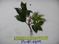 951839[1299277]Weiblen, G.D. YS4F04952010-09-08 Papua New Guinea, Morobe, Yawan Village, -6.16255 146.839933, 1721m |
MIN:Plants | 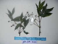 951843[1299274]Weiblen, G.D. YP3A01612010-10-29 Papua New Guinea, Morobe, Yawan Village, -6.162617 146.841967, 1777m |
MIN:Plants | 511279[]Arboretum, Cary 73-591973-00-00 United States, New York, Dutchess, Dutchess Co. |
MIN:Plants | 898315[]Smith, Welby 280301999-07-19 United States, Minnesota, Nicollet, Fort Ridgely State Park. Nicollet County...Fort Ridgely State Park, about 10 miles north of Sleepy Eye...along a small tributary of the Minnesota River...T 111N R 32W NE1/4 of NE1/4 of Sec 6. 111N 32W 6, 44.4538889 -94.735 |
MIN:Plants | 462102[]Smith, Welby 280301999-07-19 United States, Minnesota, Nicollet, Fort Ridgely State Park. Nicollet County ... Fort Ridgely State Park, about 10 miles north of Sleepy Eye ... along a small tributary of the Minnesota River ... T 111N R 32W NE1/4 of NE1/4 of Sec 6. 111N 32W 6, 44.4538889 -94.735 |
MIN:Plants | 386895[]Lee, Michael MDL35832004-05-27 United States, Minnesota, Stearns, Cold Spring Heron Colony Scientific Natural Area. Stearns County ... Cold Spring Heron Rookery Scientific & Natural Area, along the Saulk River two miles east- northeast (downstream) of Cold Spring ... T123N R30W SW1/4 of NE1/4 sec.13. 123N 30W 13, 45.462715 -94.394215 |
MIN:Plants | 914166[]Smith, Welby 250591994-08-10 United States, Minnesota, Nicollet, Nicollet County...In 7 Mile Creek County Park; about 7 miles north of Mankato...T 109N R 17W NW1/4 of NE1/4 of Sec 11;Seven Mile Creek County Park;109N;27W;11, 44.2680556 -94.0344444 |
MIN:Plants | 429090[]Smith, Welby 146561988-07-27 United States, Minnesota, Fillmore, Fillmore County ... About 1 mile S-SW of Peterson ... Root River Valley ... NE1/4 NW1/4 Section 31, T 104N R 8W;;104N;08W;31, 43.77252 -91.842773 |
MIN:Plants | 475227[]Lee, Michael MDL16061996-09-20 United States, Minnesota, Kandiyohi, Kandiyohi County ... On narrow peninsula of land between Kasota & Little Kandiyohi Lakes eight miles southeast of Willmar ... T119N R34W N1/2 SW1/4 Sec. 36. 119N 34W 36, 45.073568 -94.890137 |
MIN:Plants | 905273[]Smith, Welby 294182003-07-17 United States, Minnesota, Martin, Martin County...Timberlane County Park, on the north side of Iowa Lake...T101N R30W SW1/4 of NW1/4 of Sec 32;Timberlane County Park;101N;30W;32, 43.5116667 -94.4633333 |
MIN:Plants | 489445[]Smith, Welby 260451996-05-28 United States, Minnesota, Houston, Dorer Memorial Hardwood State Forest. Houston County ... About 4 miles northwest of Caledonia at the 'Houston County Outdoor Classroom' ... T 103N R 6W NW1/4 of SW1/4 of Sec 27. 103N 06W 27, 43.695904 -91.541372 |
MIN:Plants | 898320[]Smith, Welby 259501995-09-08 United States, Minnesota, Redwood, Redwood County...In Alexander Ramsey Municipal Park in Redwood Falls...along the Redwood River...T113N R36W NW1/4 of SE1/4 of Sec 36. 113N 36W 36, 44.5466667 -95.1269444 |
MIN:Plants | 427035[]Smith, Welby 274361998-07-23 United States, Minnesota, Renville, Town & Country County Park. Renville County ... Town and Country County Park, about 4 miles N of Delhi, in the Minnesota River valley ... T 114N R 36W NE1/4 of NW1/4 of Sec 30. 114N 36W 30, 44.6538887 -95.2277756 |
MIN:Plants | 428955[]Smith, Welby 277521999-05-17 United States, Minnesota, Olmsted, Dorer Memorial Hardwood State Forest. Olmsted County ... On the west side of the North Branch Root River about 5 miles NE of Stewartville ... T 105N R 13W SW1/4 of SE1/4 of sec 17. 105N 13W 17, 43.8927765 -92.4041672 |
MIN:Plants | 462041[]Smith, Welby 277521999-05-17 United States, Minnesota, Olmsted, Dorer Memorial Hardwood State Forest. Olmsted County ... On the west side of the North Branch Root River; about 5 miles NE of Stewartville ... T 105N R 13W SW1/4 of SE1/4 of sec 17. 105N 13W 17, 43.8927765 -92.4041672 |
MIN:Plants | 493851[]Smith, Welby 288522000-07-28 United States, Minnesota, Houston, Houston County ... Reno State Recreation Area about 1 mi N-NW of the town of Reno ... T102N R4W SE1/4 of NW1/4 of Sec 26;Dorer Memorial Hardwood State Forest;102N;04W;26, 43.6091652 -91.2861099 |
MIN:Plants | 511281[]Bright, R. 72-921972-00-00 United States, Minnesota, Hennepin, [no further data];;;;, 44.97441 -93.233002 |
MIN:Plants | 511708[]US Nat. Arboretum staff 2071978-00-00 United States, Maryland, Frederick, [no further data] |
MIN:Plants | 150723[]Sandberg, John s.n.1881-05-00 United States, Minnesota, Goodhue, Cannon Falls;;N;;, 44.506911 -92.905484 |
MIN:Plants | 150724[]Sandberg, John s.n.1882-05-00 United States, Minnesota, Goodhue, Cannon Falls;;N;;, 44.506911 -92.905484 |
MIN:Plants | 150725[]Anderson, A. s.n.1891-06-00 United States, Minnesota, Goodhue, Burnside;;113N;14W;, 44.561513 -92.532547 |
MIN:Plants | 150726[]Sheldon, Edmund S1721891-06-00 United States, Minnesota, Blue Earth, Eagle Lake;;N;;, 44.189661 -93.896402 |
MIN:Plants | 150727[]Sheldon, Edmund s.n.1895-05-00 United States, Minnesota, Ramsey, Groveland Park [St. Paul neighborhood between Highland and Summit aves.];;028N;23W;, 44.93059 -93.185623 |
MIN:Plants | 150728[]Rosendahl, C. 26001912-08-04 United States, Minnesota, Dakota, E of Mendota;;N;;, 44.887127 -93.146534 |
MIN:Plants | 150729[]Rosendahl, C.; Butters, F. 39151920-06-26 United States, Minnesota, Fillmore, Slope near Winch's Springs, valley of the South Fork, Amherst, Fillmore co.;Dorer Memorial Hardwood State Forest;102N;09W;, 43.630903 -91.927644 |
MIN:Plants | 150730[]Rosendahl, C. 12041903-05-16 United States, Minnesota, Houston, Spring Grove;;101N;07W;, 43.543165 -91.672028 |
MIN:Plants | 150731[]Manning, Sara s.n.1883-06-25 United States, Minnesota, Wabasha, Lake City;;111N;12W;, 44.449412 -92.266844 |
MIN:Plants | 150732[]Manning, Sara s.n.1898-05-19 United States, Minnesota, Wabasha, Lake City;;111N;12W;, 44.449412 -92.266844 |
MIN:Plants | 150733[]Sheldon, Edmund S3131891-06-00 United States, Minnesota, Blue Earth, Stony Point, Lake Madison;;N;;, 44.191377 -93.808724 |
MIN:Plants | 150734[]Rosendahl, C. 3071902-06-03 United States, Minnesota, Houston, Spring Grove;;101N;07W;, 43.543165 -91.672028 |
MIN:Plants | 150735[]Sheldon, Edmund S6281891-06-00 United States, Minnesota, Waseca, Wilton;;N;;, 44.013852 -93.534387 |
MIN:Plants | 150736[]Holzinger, John s.n. United States, Minnesota, Winona, Winona;;N;;, 44.0333 -91.6333 |
MIN:Plants | 150737[]Wheeler, William 2021899-06-15 United States, Minnesota, Houston, Winnebago Valley, Houston Co.;Dorer Memorial Hardwood State Forest;N;;, 43.537379 -91.40119 |
MIN:Plants | 150738[]Sheldon, Edmund S7051891-07-00 United States, Minnesota, Ramsey, White Bear Lake. Ramsey Co.;;030N;22W;, 45.084446 -93.000327 |
MIN:Plants | 150739[]Sheldon, Edmund S5531891-06-00 United States, Minnesota, Waseca, Waseca;;N;;, 44.077741 -93.507443 |
MIN:Plants | 264157[]Holzinger, John s.n.1901-06-00 United States, Minnesota, Winona, Winona Co.;;N;;, 43.98685 -91.779129 |
MIN:Plants | 288539[]Beach, W. 51914-05-19 United States, Minnesota, Hennepin, Minnehaha Glen, Minneapolis;;N;;, 44.914688 -93.209944 |
MIN:Plants | 288599[]Jahnke, E. s.n.1914-05-19 United States, Minnesota, Hennepin, Minnehaha Glen;;N;;, 44.914688 -93.209944 |
MIN:Plants | 364495[]Holzinger, John s.n.1901-05-00 United States, Minnesota, Winona, Winona Co.;;N;;, 43.98685 -91.779129 |
MIN:Plants | 381526[]Moore, John; et al. 142271942-05-02 United States, Minnesota, Houston, 1/2 mi S of the Root River, S of the bridge, Houston. Houston Co.;Dorer Memorial Hardwood State Forest;;;, 43.764984 -91.488825 |
MIN:Plants | 413045[]Moore, John 106871939-05-14 United States, Minnesota, Wabasha, Bluffs of the Mississippi River Valley, 1.6 mi below Lake City;;111N;12W;, 44.42624 -92.266844 |
MIN:Plants |  437408[]Moore, John; Barnum, B. 161891944-05-22 United States, Minnesota, Washington, Washington co.; Creek 3 mi north west of Stillwater;;030N;20W;, 45.099614 -92.806721 |
MIN:Plants | 440075[]Deters, M. s.n.1933-00-00 United States, Minnesota, [Lake] Pokegama;;;;, 45.840024 -93.039931 |
MIN:Plants | 464308[]Lee, Michael MDL11881996-05-28 United States, Minnesota, Winona, Winona Co.; small valley three miles north of Rushford; T105N R8W NW1/4 SW1/4 Sec. 26;Dorer Memorial Hardwood State Forest;105N;08W;26, 43.867967 -91.867773 |
MIN:Plants | 466698[]Kruse, K. 023 KMK1994-05-21 United States, Minnesota, Goodhue, Frontenac State Park. Goodhue Co.; T: 112N R: 13W Sec: 2 Quarter SEc: N 1/2;Frontenac State Park;112N;13W;2, 44.534004 -92.339261 |
MIN:Plants | 466706[]Kruse, K. 007 KMK1994-05-20 United States, Minnesota, Goodhue, Frontenac State Park. Goodhue Co.; T: 112N R: 13W Sec: 2 Quarter Sec: N 1/2;Frontenac State Park;112N;13W;2, 44.534004 -92.339261 |
MIN:Plants | 484601[]Wheeler, Gerald 156751997-05-23 United States, Minnesota, Renville, Renville Co.; Ca. 15 mi. S of Danube on Rte. 1, W of road; NW1/4 NE1/4 SW1/4 Sec. 20 T113N R35W (Beaver Falls 20);;113N;35W;20, 44.578346 -95.085406 |
MIN:Plants | 515557[]Smith, Welby 146561988-07-27 United States, Minnesota, Fillmore, Fillmore Co.; about 1 mile S-SW of Peterson; in the Root River Valley; NE1/4 NW1/4 sec.31, T 104N R 8W;;104N;08W;31, 43.772768 -91.842744 |
MIN:Plants | 558629[]Moore, John 237331958-05-27 United States, Minnesota, Blue Earth, Bluff of the Minnesota River at Mankato;;N;;, 44.163578 -93.9994 |
MIN:Plants | 566737[]Lang, H.; et al. 501870-05-20 United States, Minnesota, Ramsey, St. Paul;;;;, 44.9442 -93.0936 |
MIN:Plants | 585522[]Moore, John; et al. 260151962-06-05 United States, Minnesota, Houston, Houston County...Along Badger Creek, 6 mi S of Houston;Dorer Memorial Hardwood State Forest;;;, 43.695487 -91.553345 |
MIN:Plants | 595461[]Vogel, A. 551965-05-16 United States, Minnesota, Brown, KC road, 3.5 mi N of New Ulm, Minn. R. valley, along roadside;;N;;, 44.355912 -94.460529 |
MIN:Plants | 621347[]Smithburg, M.; et al. s.n.1970-10-03 United States, Minnesota, Anoka, Anoka County. On island in Lake Peltier;Rice Creek Chain of Lakes County Park;031N;22W;00, 45.186252 -93.058221 |
MIN:Plants | 630414[]Morley, T. 12791972-10-15 United States, Minnesota, Wright, On island in Mississippi River ca. 2 mi SE of Big Lake, on E 1/2 of island; lots 3 and 4, Sec. 9 T121N R24W;;121N;24W;9, 45.297313 -93.715728 |
MIN:Plants | 671226[]Crawford, Dave 0011975-08-03 United States, Minnesota, Chisago, Interstate State Park on trail upstream from campground near lower contact station, near St. Croix River;Interstate State Park;034N;19W;, 45.393636 -92.667249 |
MIN:Plants | 680738[]Clemants, Steven 6471977-05-08 United States, Minnesota, Fillmore, Fillmore Co. North Branch Root River; T104N R10W Sec. 28 SE1/4 and Sec. 33 NE1/4;Dorer Memorial Hardwood State Forest;104N;10W;, 43.774766 -92.039209 |
MIN:Plants | 681788[]Wheeler, Gerald 11161977-05-18 United States, Minnesota, Olmsted, Dorer Memorial Hardwood State Forest. Olmsted Co. Approx. 3 mi S of Simpson on hwy 1 and about 1/2 mi SSE of the bridge over the Root River following the S ba Olmsted Co. Approx. 3 mi S of Simpson on hwy 1 and about 1/2 mi SSE of the bridge over the Root River following the S bank of the river; T105N R13W Sec. 20. 105N 13W 20, 43.885668 -92.407899 |
MIN:Plants | 701546[]Ownbey, Gerald 62231979-06-13 United States, Minnesota, Washington, Bluffs of the Mississippi River; T26N R20W W1/2 Sec. 7;;026N;20W;7, 44.754163 -92.850962 |
MIN:Plants | 724702[]Smith, Welby 26741980-06-26 United States, Minnesota, Houston, Houston Co. Ca. 3/4 mi N of New Albin, and 1/4 mi W of hwy 26; T101N R4W SE1/4 NW1/4 Sec. 35;Dorer Memorial Hardwood State Forest;101N;04W;35, 43.509557 -91.285188 |
MIN:Plants | 724714[]Smith, Welby 22511980-05-27 United States, Minnesota, Winona, Winona Co. In the valley of Bear Creek, ca. 1 mi E of Altura; T107N R9W SW1/4 Sec. 16;Dorer Memorial Hardwood State Forest;107N;09W;16, 44.06641 -91.909908 |
MIN:Plants | 728511[]Lustig, K. 3311979-05-31 United States, Minnesota, Sherburne, Mississippi River Islands Scientific Natural Area. Sherburne & Wright Cos. ...Mississippi Scenic and Recreational River Islands SNA, Mississippi River Islands between Monticello and Elk River. Sec. 2, 3, 4, T32N, R26, 27W; sec. 7, 9, 18, T121N, R23, 24W. 032N 26W 3, 45.301026 -93.662501 |
MIN:Plants | 738414[]Galatowitsch, S. 1251982-05-20 United States, Minnesota, Goodhue, Binger's Farm, Tract II; T112N R13W NW1/4 Sec. 33 SE1/4 NE1/4 Sec. 32;;112N;13W;, 44.467627 -92.39004 |
MIN:Plants | 747216[]Galatowitsch, S. 8151982-09-11 United States, Minnesota, Houston, Caledonia Oaks; T102N R5W E1/2 SW1/4 Sec. 24;Caledonia Oaks, The Nature Conservancy;102N;05W;24, 43.623103 -91.382423 |
MIN:Plants | 763972[]Lugger, O. s.n.1892-05-30 United States, Minnesota, Hennepin, Lake Harriet;;N;;, 44.921821 -93.304866 |
MIN:Plants | 782272[]Tenney, M. 5961982-09-06 United States, Minnesota, Fillmore, Forestville State Park, Fillmore Co. T102N R12W Sec. 24 SE1/4 SE1/4 NW1/4;Forestville State Park;102N;12W;24, 43.624529 -92.21074 |
MIN:Plants | 787557[]Smith, Welby 100771985-05-03 United States, Minnesota, Fillmore, Dorer Memorial Hardwood State Forest. Fillmore County...On slope along the South Branch Root River, about 3 mi NNW of Greenleafton; SW1/4 NE1/4 SE1/4 Sec. 23 T102N R12W. 102N 12W 23, 43.6205556 -92.2322222 |
MIN:Plants | 793065[]Morley, T. 16671986-05-04 United States, Minnesota, Rice, Rice Co. Prairie Creek, W side of stream; T110N R19W S1/2 Sec. 3;Prairie Creek Woods Scientific Natural Area;110N;19W;3, 44.32897 -93.196369 |
MIN:Plants | 800189[]Cholewa, A. 16281989-05-23 United States, Minnesota, Washington, Carpenter Nature Center. Washington Co, T26N R20W S4...S end of railroad trail;Carpenter Nature Center;026N;20W;04, 44.768259 -92.812758 |
MIN:Plants | 841701[]Smith, Welby 136641987-07-31 United States, Minnesota, Washington, Washington County...On Upper Grey Cloud Island in the Mississippi River, about 3 mi S of St. Paul Park. NE1/4 NW1/4 sec. 35, T27N R22W. 027N 22W 35, 44.7886111 -93.0194444 |
MIN:Plants | 910026[]Smith, Welby 245381994-07-02 United States, Minnesota, Scott, Scott County...In the Minnesota Valley, about 7.5 miles north of Jordan...T 115N R 23W SE1/4 of NW1/4 of Sec 9;;115N;23W;09, 44.77986 -93.58992 |
MIN:Plants | 906150[]Clancy, J.; et al. 122008-09-27 United States, Minnesota, Hennepin, Minnehaha Falls Park. Hennepin County, Minnehaha Falls Park, approximately 0.25 miles south east of Falls, along...Minnehaha Creek, 100 feet south of Den Pen Area Bridge. 1/2SE of 1/4NE of Section 18, Township 28N, Range 23W.. 028N 23W 18, 44.9147222 -93.2097222 |
MIN:Plants | 904716[]Smith, Welby 277371999-05-16 United States, Minnesota, Steele, About 4 miles NW of Claremont. NE1/4 of SE1/4 of section;Rice Lake State Park;107N;19W;11, 44.0866667 -93.0675 |
MIN:Plants | 475214[]Juhnke, C. 181 CMJ FRO1999-05-05 United States, Minnesota, Goodhue, Frontenac State Park Goodhue County ... behind picnic shelter ... T112N R13W NW SW NE 2;Frontenac State Park;112N;13W;02, 44.5075 -92.32611 |
MIN:Plants | 429050[]Smith, Welby 245381994-07-02 United States, Minnesota, Scott, Scott County ... In the Minnesota Valley, about 7.5 miles north of Jordan ... T 115N R 23W SE1/4 of NW1/4 of Sec 9;;115N;23W;09, 44.782176 -93.590648 |
MIN:Plants | 455595[]Smith, Welby 288952000-08-02 United States, Minnesota, Goodhue, Goodhue County ... Frontenac State Park, about 2 miles N-NE of Frontenac (town) ... T112N R13W NW1/4 of SE1/4 of Sec 2;Frontenac State Park;112N;13W;02, 44.5341682 -92.3349991 |
MIN:Plants | 459920[]Biederman, L. 4142000-07-11 United States, Minnesota, Rice, Rice Co.; island between Prairie Creek and an old Channel; T110N R19W NWNW10;;110N;19W;10, 44.348614 -93.212076 |
MIN:Plants | 909806[]Smith, Welby 253401994-08-30 United States, Minnesota, Blue Earth, Blue Earth County ... Minneopa State Park, about 3 miles west of Mankato ... T108N R27W NW1/4 of NW1/4 of Sec 21;Minneopa State Park;108N;27W;21, 44.1480556 -94.0861111 |
MIN:Plants | 489295[]Smith, Welby 165891990-05-15 United States, Minnesota, Faribault, Fairbault County ... About 3.5 miles east-southeast of Huntley ... Blue Earth River Valley ... T103N R28W SW1/4 of SW1/4 of Sec 14. 103N 28W 14, 43.7194443 -94.1655579 |
MIN:Plants | 428949[]Smith, Welby 289952000-08-16 United States, Minnesota, Fillmore, Forestville State Park. Fillmore County ... Forestville State Park, about 3 miles SW of Carimona ... Root River ... T 102N R 11W SW1/4 of NW1/4 of Sec 18. 102N 11W 18, 43.6402779 -92.2074966 |
MIN:Plants | 920827[]Smith, Welby 221021993-05-12 United States, Minnesota, Sibley, Sibley County ... Minnesota Valley, about 3 miles north-northwest of Henderson ... T113N R26W NE1/4 of SE1/4 of Sec 22;;113N;26W;22, 44.5769444 -93.9313889 |
MIN:Plants | 477029[]Wheeler, Gerald 185461998-05-07 United States, Minnesota, Nicollet, Nicollet County ... Ca. 2.5 mi. NW of Courtland on Rte. 14; Red Rock area ... E1/2 SE1/4 SW1/4 Sec. 34 T110N R30W;;110N;30W;34, 44.292954 -94.420107 |
MIN:Plants | 923158[]Smith, Welby 237861993-09-01 United States, Minnesota, Mower, Lake Louise State Park. Lake Louise State Park, about 1 mile north-northwest of LeRoy. At the confluence of the Upper Iowa and the Little Iowa Rivers...T 101N R 14W NW1/4 of NE1/4 of Sec 28. 101N 14W 28, 43.5272222 -92.5177778 |
MIN:Plants | 454850[]Partch, M. s.n.1976-06-05 United States, Minnesota, Stearns, Stearns County;Cold Spring Heron Colony Scientific Natural Area;;;, 45.453611 -94.427778 |
MIN:Plants | 934265[]Partch, M. s.n.1965-06-28 United States, Minnesota, Stearns, Wakefield Township;Cold Spring Heron Colony Scientific Natural Area;123N;30W;13, 45.453611 -94.427778 |
MIN:Plants | 447840[]Sanders, Suzanne 2014-05-30 United States, Minnesota, Pine, Located off the west bank of the St. croix River between Little Yellow Banks Landing and the state park Main Landing; approx. 540 m upstream from confluence with Clam River (on WIS side); 40 m due W from riverbank. UTM: 534773E, 5089231N;Saint Croix State Park;;;, 45.9557681 -92.5512811 |
MIN:Plants |  961468[1334921] United States, Indiana |
MIN:Plants | []Timothy J. S. Whitfeld 31872022-06-03 United States, Minnesota, Washington, Crystal Spring Scientific and Natural Area, 0.4 miles northeast of the intersection of Scandia Trail North and Hwy 95, 45.2598969 -92.764188, 250m |
MIN:Plants | 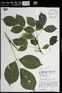 971175[1394648]Nee, M.H. 653722019-08-30 United States, Wisconsin, Grant, Wyalusing State Park, Walnut Forest State Natural Area. Mississippi River valley, S of confluence with Wisconsin River. Near currently maintained “Old Immigrant Trail”, at base of trail down from Sentinel Ridge Trail., 42.995556 -91.121111, 200m |
MIN:Plants | []Timothy J. S. Whitfeld 35372023-05-24 United States, Minnesota, Washington, Crystal Spring Scientific and Natural Area, 0.4 miles northeast of the intersection of Scandia Trail North and Hwy 95, 45.25901 -92.76401, 263m |
MIN:Plants | Staphylea bolanderi A. Gray 240235[]Congdon, J. s.n.1886-05-00 United States, California, Mariposa, Snow Creek;Yosemite National Park |
MIN:Plants | Staphylea bolanderi A. Gray 240234[]Congdon, J. s.n.1888-05-21 United States, California, Mariposa, North side Hite's Cove Mt, Mariposa County;Yosemite National Park |
MIN:Plants | Staphylea bolanderi A. Gray 239731[]Congdon, J. s.n.1888-04-08 United States, California, Mariposa, Devil's Gulch, Mariposa County;Yosemite National Park |
MIN:Plants | Staphylea bolanderi A. Gray 239981[]Congdon, J. s.n.1895-07-07 United States, California, Mariposa, Snow Creek;Yosemite National Park |
MIN:Plants | Staphylea bolanderi A. Gray 239977[]Congdon, J. s.n.1885-06-00 United States, California, Mariposa, Devil's Gulch, Mariposa County;Yosemite National Park |
MIN:Plants | 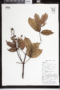 Turpinia pentandra (Schltr.) B.L.Linden 958173[1299370]Weiblen, G.D. YP3A01502010-10-29 Papua New Guinea, Morobe, -6.16262 146.84197 |
MIN:Plants | 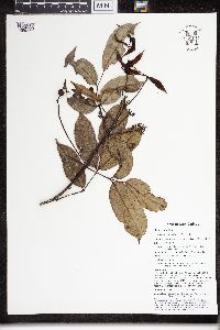 Turpinia pentandra (Schltr.) B.L.Linden 958174[1299371]Weiblen, G.D. YP4A02282010-11-09 Papua New Guinea, Morobe, -6.16262 146.84197 |
MIN:Plants | 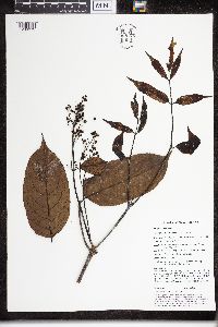 Turpinia pentandra (Schltr.) B.L.Linden 958175[1299372]Weiblen, G.D. YP4B02202012-10-18 Papua New Guinea, Morobe, -6.1637 146.84202 |
MIN:Plants |  Turpinia pentandra (Schltr.) B.L.Linden 970229[1371830]Weiblen, G. D. & Binatang Research Center NS2A01072013-10-19 Papua New Guinea, Madang, Numba, -5.7222 145.2714, 1200m |
1
Page 1, records 1-98 of 98
Google Map
Google Maps is a web mapping service provided by Google that features a map that users can pan (by dragging the mouse) and zoom (by using the mouse wheel). Collection points are displayed as colored markers that when clicked on, displays the full information for that collection. When multiple species are queried (separated by semi-colons), different colored markers denote each individual species.