University of Minnesota
http://www.umn.edu/
612-625-5000
http://www.umn.edu/
612-625-5000
Minnesota Biodiversity Atlas
Bell Museum
Dataset: MIN-Plants
Taxa: Stemonuraceae
Search Criteria: excluding cultivated/captive occurrences
1
Page 1, records 1-19 of 19
Bell Museum plants | |
 MIN:Plants | 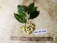 Gomphandra montana (G.Schellenb.) Sleumer 923020[]Ctvrtecka, R. 35372008-12-02 Papua New Guinea, Madang, Wanang Village, -5.23088 145.182, 115m |
MIN:Plants | Gomphandra montana (G.Schellenb.) Sleumer 896676[]Weiblen, G.D. TP1591996-07-31 Papua New Guinea, Simbu, O-Pio 1 ha plot, block 8, Crater Mountain Wildlife Management Area, -6.788611 145.036667, 550m |
MIN:Plants | Gomphandra montana (G.Schellenb.) Sleumer 897302[]Weiblen, G.D. TP2181996-07-31 Papua New Guinea, Simbu, O-Pio 1 ha plot, block 10, Crater Mountain Wildlife Management Area, -6.788611 145.036667, 550m |
MIN:Plants | Gomphandra montana (G.Schellenb.) Sleumer 896692[]Weiblen, G.D. TP2501996-07-31 Papua New Guinea, Simbu, O-Pio 1 ha plot, block 11, Crater Mountain Wildlife Management Area, -6.788611 145.036667, 550m |
MIN:Plants | 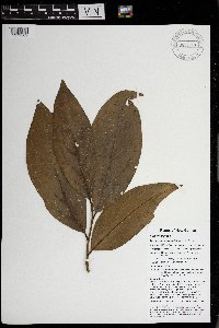 Gomphandra montana (G.Schellenb.) Sleumer 969948[1371569]Weiblen, G. D. & Binatang Research Center NP1A00442013-06-03 Papua New Guinea, Madang, Numba, -5.7222 145.2714, 1200m |
MIN:Plants | 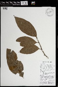 Gomphandra montana (G.Schellenb.) Sleumer 969949[1371568]Weiblen, G. D. & Binatang Research Center NP3A20232013-07-08 Papua New Guinea, Madang, Numba, -5.7222 145.2714, 1200m |
MIN:Plants | Gomphandra papuana (Becc.) Sleumer 923019[]Ctvrtecka, R. 47272008-07-27 Papua New Guinea, Madang, Ohu Village, -5.21667 145.683, 100m |
MIN:Plants | 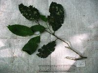 Medusanthera laxiflora (Miers) R.A.Howard 920704[]Whitfeld, T.J.S. PA1B00122008-08-13 Papua New Guinea, Madang, Wanang Village, -5.237483 145.115733, 129m |
MIN:Plants | 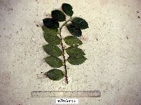 Medusanthera laxiflora (Miers) R.A.Howard 916802[]Weiblen, G.D. & Binatang Research Center WP2A04322007-07-12 Papua New Guinea, Madang, Wanang Village, -5.2373 145.177183, 115m |
MIN:Plants | 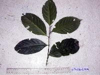 Medusanthera laxiflora (Miers) R.A.Howard 916804[]Weiblen, G.D. & Binatang Research Center WP2A21062006-03-30 Papua New Guinea, Madang, Wanang Village, -5.2373 145.177183, 115m |
MIN:Plants | 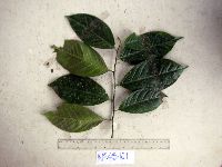 Medusanthera laxiflora (Miers) R.A.Howard 916789[]Weiblen, G.D. & Binatang Research Center WP4B10112007-08-13 Papua New Guinea, Madang, Wanang Village, -5.2373 145.177183, 115m |
MIN:Plants | 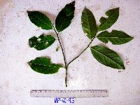 Medusanthera laxiflora (Miers) R.A.Howard 916803[]Weiblen, G.D. & Binatang Research Center WP4C09132007-04-07 Papua New Guinea, Madang, Wanang Village, -5.2373 145.177183, 115m |
MIN:Plants | 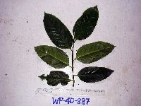 Medusanthera laxiflora (Miers) R.A.Howard 916787[]Weiblen, G.D. & Binatang Research Center WP4D08872007-03-20 Papua New Guinea, Madang, Wanang Village, -5.2373 145.177183, 115m |
MIN:Plants | 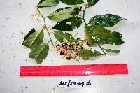 Medusanthera laxiflora (Miers) R.A.Howard 923029[]Ctvrtecka, R. 23232008-09-23 Papua New Guinea, Madang, Mis Village, -5.15 145.783, 10m |
MIN:Plants | 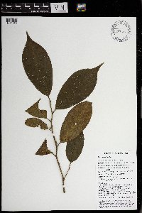 Medusanthera laxiflora (Miers) R.A.Howard 970077[1371669]Weiblen, G. D. & Binatang Research Center NP1B00772014-04-09 Papua New Guinea, Madang, Numba, -5.7222 145.2714, 1200m |
MIN:Plants | 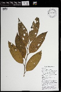 Medusanthera laxiflora (Miers) R.A.Howard 970075[1371671]Weiblen, G. D. & Binatang Research Center NP2B01312014-03-29 Papua New Guinea, Madang, Numba, -5.7222 145.2714, 1200m |
MIN:Plants | 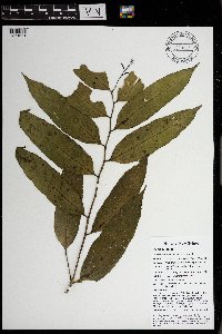 Medusanthera laxiflora (Miers) R.A.Howard 970085[1371661]Weiblen, G. D. & Binatang Research Center NP3B02362014-04-23 Papua New Guinea, Madang, Numba, -5.7222 145.2714, 1200m |
MIN:Plants | 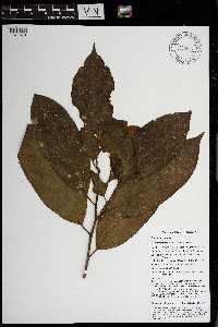 Medusanthera laxiflora (Miers) R.A.Howard 970076[1371670]Weiblen, G. D. & Binatang Research Center NS3A01532013-10-26 Papua New Guinea, Madang, Numba, -5.7222 145.2714, 1200m |
MIN:Plants | 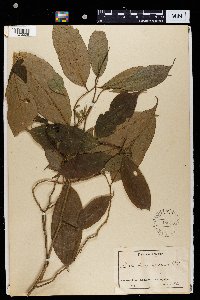 Lasianthera africana P. Beauv. 150755[1372006]Staudt 4901896-00-00 Cameroon, Johann-Albrechtshohe. Urwaldgebiet |
1
Page 1, records 1-19 of 19
Google Map
Google Maps is a web mapping service provided by Google that features a map that users can pan (by dragging the mouse) and zoom (by using the mouse wheel). Collection points are displayed as colored markers that when clicked on, displays the full information for that collection. When multiple species are queried (separated by semi-colons), different colored markers denote each individual species.