University of Minnesota
http://www.umn.edu/
612-625-5000
http://www.umn.edu/
612-625-5000
Minnesota Biodiversity Atlas
Bell Museum
Dataset: MIN-Plants
Taxa: Taxaceae
Search Criteria: excluding cultivated/captive occurrences
Bell Museum plants | |
 MIN:Plants | Torreya californica Torrey 357717[]Ericson, Mildred s.n.1939-06-29 United States, California, Arch Rock Ranger Station, Yosemite National Park;Yosemite National Park, 1219m |
MIN:Plants | Torreya californica Torrey 240279[]Congdon, J. s.n.1883-06-00 United States, California, Mariposa, Yosemite Trail, Mariposa County;Yosemite National Park |
MIN:Plants | Torreya californica Torrey 55871[]Clark, Galen s.n.1896-05-29 United States, California, Yosemite;Yosemite National Park |
MIN:Plants | Torreya californica Torrey 523668[]Cooper, William Eh71904-08-00 United States, California, Yosemite Valley;Yosemite National Park |
MIN:Plants | 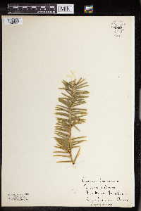 Torreya californica Torrey 861857[1340362] United States, California |
MIN:Plants | Taxus brevifolia Nuttall 55818[]Elmer, A.D.E. 24861900-07-00 United States, Washington, Clallam, Olympic Mts. [Olympic National Park] |
MIN:Plants | Taxus brevifolia Nuttall 293055[]Buell, Murray 9801934-09-03 United States, Montana, Flathead, trail to Avalanche Lake, Glacier Nat'l. Park;Glacier National Park |
MIN:Plants | 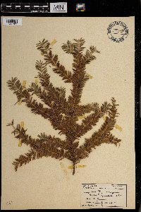 Taxus brevifolia Nuttall 0968705[1391303]Bieberdorf, F. s.n.1938-00-00 United States, Wyoming |
MIN:Plants | Taxus canadensis Marshall 55831[]Sandberg, John s.n.1889-07-00 United States, Michigan, Keweenaw, Isle Royale;Isle Royale National Park |
MIN:Plants | Taxus canadensis Marshall 910081[]Lee, Michael; et al. MDL42322006-06-13 United States, Minnesota, Becker, White Earth Indian Reservation. Becker County...five miles southeast of the village of White Earth...island in Big Sugar Bush Lake...T141N R40W S1/2 of NW1/4 of SE1/4 Sec. 8. 141N 40W 8, 47.037505 -95.772715 |
MIN:Plants | Taxus canadensis Marshall 905251[]Gerdes, Lynden; et al. 44172001-07-26 United States, Minnesota, Cook, T59N R04W S01NWSW. Cook County...Leveaux Mountain. Approximately 4.0 miles NE of Tofte;North Shore / Superior National Forest;059N;04W;01, 47.623034 -90.777434 |
MIN:Plants | Taxus canadensis Marshall 438426[]Cochran, Philip; Cochran, Joseph s.n.2006-08-03 United States, Minnesota, Olmsted, Olmsted Co, along North Branch Root River - 50-150 m upstream from State Highway 19 crossing;;104N;13W;14, 43.904284 -92.339121 |
MIN:Plants | Taxus canadensis Marshall 55841[]Wheeler, William 7851900-08-00 United States, Michigan, Keweenaw, Tobin Harbor, Isle Royale;Isle Royale National Park |
MIN:Plants | Taxus canadensis Marshall 55848[]Sheldon, Edmund S.40201892-09-00 United States, Wisconsin, Polk, Osceola;Saint Croix National Riverway;;;, 45.32052 -92.70493 |
MIN:Plants | Taxus canadensis Marshall 492457[]Smith, Welby 272071998-06-04 United States, Minnesota, Cook, North Shore / Superior National Forest. Cook County ... east bank of the Cascade River, about 2.5 air mi from Lake Superior ... T 60N [should be T61] R 2W NE1/4 of NW1/4 of sec 25. 060N 02W 25, 47.7452774 -90.5258331 |
MIN:Plants | Taxus canadensis Marshall 220261[]Rosendahl, C. 55011927-10-08 United States, Minnesota, Anoka, NE of Ham Lake. Anoka Co.;;032N;23W;, 45.257018 -93.222366 |
MIN:Plants | Taxus canadensis Marshall 220268[]Cloutier, H. s.n.1943-07-20 United States, Minnesota, Itasca, Itasca co, Coleraine, Trout Lake vicinity;;N;;, 47.28883 -93.427708 |
MIN:Plants | Taxus canadensis Marshall 229264[]Stork, H. 11061925-00-00 United States, Minnesota, Itasca, Bowstring;Chippewa National Forest;;;, 47.54306 -93.79639 |
MIN:Plants | Taxus canadensis Marshall 281988[]Butters, F.; et al. 62341930-08-19 United States, Minnesota, Cook, Lucile Island. Cook Co.;North Shore / Susie Islands, The Nature Conservancy;063N;07E;, 47.973776 -89.578978 |
MIN:Plants | Taxus canadensis Marshall 282259[]Gilbert, H. 111923-05-09 United States, Minnesota, Saint Louis, N of Duluth;;N;;, 46.783273 -92.106579 |
MIN:Plants | Taxus canadensis Marshall 283959[]Butters, F.; Buell, Murray 3361932-07-07 United States, Minnesota, Cook, McFarland Lake, Cook Co.;Superior National Forest;064N;03E;, 48.048363 -90.064709 |
MIN:Plants | Taxus canadensis Marshall 284464[]Rosendahl, C. 57921929-05-22 United States, Minnesota, Anoka, Northern Anoka Co.;;N;;, 45.273242 -93.246467 |
MIN:Plants | Taxus canadensis Marshall 297553[]Moyle, J.; et al. 17131934-08-14 United States, Minnesota, Otter Tail, McDonald Lake, Ottertail Co.;;;;, 46.574253 -95.76442 |
MIN:Plants | Taxus canadensis Marshall 305970[]Gunderson, Harvey s..1940-07-02 United States, Minnesota, Saint Louis, Along Lester River, Duluth;;N;;, 46.921472 -92.048391 |
MIN:Plants | Taxus canadensis Marshall 306849[]Moyle, J.; et al. 17131934-08-14 United States, Minnesota, Otter Tail, Lake Mac Donald. Ottertail Co.;;;;, 46.574253 -95.76442 |
MIN:Plants | Taxus canadensis Marshall 307221[]Rosendahl, C. 20181935-06-21 United States, Minnesota, Mahnomen, 4 mi E of Beaulieu, Mahnomen Co.;White Earth Indian Reservation;145N;40W;, 47.335484 -95.719042 |
MIN:Plants | Taxus canadensis Marshall 335565[]Zeck, Otto 1051933-09-17 United States, Minnesota, Becker, Detroit Lakes, Becker Co.;;N;;, 46.817181 -95.845325 |
MIN:Plants | Taxus canadensis Marshall 346206[]Moyle, J. 27601937-07-31 United States, Minnesota, Anoka, Cedar Creek Bog, Anoka Co.;Cedar Creek National History Area;034N;23W;, 45.40217 -93.199397 |
MIN:Plants | Taxus canadensis Marshall 346208[]Grant, Martin 68461936-08-29 United States, Minnesota, Clearwater, Itasca Park. Clearwater Co. Elk Lake. SE-SE-16 T143 R36.;Itasca State Park;143N;36W;16, 47.202671 -95.244357 |
MIN:Plants | Taxus canadensis Marshall 352686[]Benner, F.; Benner, J. 6771929-08-23 United States, Minnesota, Cook, W of hwy.#1 about 1 mi N Mineral Center;;N;;, 47.947665 -89.780647 |
MIN:Plants | Taxus canadensis Marshall 354063[]Lakela, Olga 26931938-08-06 United States, Minnesota, Saint Louis, Hwy.61, about 17 mi from Duluth, St. Louis Co.;;N;;, 46.7833 -92.1 |
MIN:Plants | Taxus canadensis Marshall 363864[]Moyle, J. 35821940-07-02 United States, Minnesota, Saint Louis, Along Lester R. near Duluth. St. Louis Co.;;N;;, 46.921472 -92.048391 |
MIN:Plants | Taxus canadensis Marshall 363875[]Gilbert, H. 111983-05-08 United States, Minnesota, Saint Louis, N of Duluth, St. Louis Co.;;N;;, 46.783273 -92.106579 |
MIN:Plants | Taxus canadensis Marshall 364567[]Butters, F.; et al. s.n.1934-08-00 United States, Minnesota, Cook, 1/4 mi south of Gunflint Lake, Cook Co.;Boundary Waters Canoe Area Wilderness / Superior National Forest;065N;03W;00, 48.078804 -90.739511 |
MIN:Plants | Taxus canadensis Marshall 365157[]Buell, Murray 20641940-08-29 United States, Minnesota, Hubbard, SW of Lake George, Hubbard Co.;;N;;, 47.173088 -94.971569 |
MIN:Plants |  Taxus canadensis Marshall 366557[]Rosendahl, C. 73951939-10-06 United States, Minnesota, Fillmore, Sec.24, Amherst Twp, Fillmore Co.;;102N;09W;24, 43.623312 -91.860019 |
MIN:Plants | Taxus canadensis Marshall 366574[]Rosendahl, C. 74241940-05-22 United States, Minnesota, Houston, Valley of Riceford Creek, Sec.29, Black Hammer Twp, Houston Co.;Dorer Memorial Hardwood State Forest;102N;07W;29, 43.608975 -91.700954 |
MIN:Plants | Taxus canadensis Marshall 370329[]Moore, John; et al. 137501941-04-26 United States, Minnesota, Washington, Above inlet, North Grey Cloud Island, Washington Co.;;027N;22W;, 44.789016 -92.997959 |
MIN:Plants | Taxus canadensis Marshall 375183[]Mickelson, Lillian s.n.1942-08-23 United States, Minnesota, Saint Louis, Palo;;057N;15W;, 47.415205 -92.259625 |
MIN:Plants | Taxus canadensis Marshall 375206[]Lakela, Olga 49721942-06-07 United States, Minnesota, Lake, On Knife Island, 1/2 mi out in Lake Superior, Knife River, Lake Co.;;N;;, 46.946524 -91.794017 |
MIN:Plants | Taxus canadensis Marshall 381421[]Moore, John; et al. 156871942-09-24 United States, Minnesota, Olmsted, Pleasant Grove Twp, Sec.20. Olmstead Co.;Dorer Memorial Hardwood State Forest;105N;13W;20, 43.884226 -92.408042 |
MIN:Plants | Taxus canadensis Marshall 385581[]U.S. Dept. of Agriculture personnel s.n.1938-05-05 United States, Minnesota, Lake, Lake County...Superior Forest. NE-NW Sec.15, T56N R10W;Superior National Forest;056N;10W;15, 47.335541 -91.589861, 457m |
MIN:Plants | Taxus canadensis Marshall 393289[]Ownbey, Gerald; et al. 11281948-08-18 United States, Minnesota, Cook, Cook County...NW bay of Susie Island, Susie Islands near Grand Portage;North Shore / Susie Islands, The Nature Conservancy;064N;07E;, 47.973776 -89.578978 |
MIN:Plants | Taxus canadensis Marshall 393787[]Nielsen, E. 16731932-09-12 United States, Minnesota, Cook, Island in inlet of Saganaga Lake, Cook Co.;Boundary Waters Canoe Area Wilderness / Superior National Forest;;;, 48.21151 -90.917295 |
MIN:Plants | Taxus canadensis Marshall 393788[]Nielsen, E. 16251932-09-09 United States, Minnesota, Cook, Pigeon Point, near Grand Portage, Cook Co.;Grand Portage Indian Reservation / North Shore;064N;07E;, 47.997942 -89.538143 |
MIN:Plants | Taxus canadensis Marshall 393789[]Dahl, A. 251945-06-16 United States, Minnesota, Cook, Cook Co. Near Poplar Lake, T64N R1W 5;Boundary Waters Canoe Area Wilderness / Superior National Forest;064N;01W;5, 48.046734 -90.508674 |
MIN:Plants | Taxus canadensis Marshall 393790[]Butters, F.; Abbe, E. 1391936-06-27 United States, Minnesota, Cook, Cook Co. Winchell Lake, T64N R2W;Boundary Waters Canoe Area Wilderness / Superior National Forest;064N;02W;, 47.991965 -90.603633 |
MIN:Plants | Taxus canadensis Marshall 393791[]Butters, F.; Abbe, E. 881936-06-22 United States, Minnesota, Cook, Cook Co. ClearwaterLake at base of 1st cliff. T65N R1E.;Boundary Waters Canoe Area Wilderness / Superior National Forest;065N;01E;, 47.726653 -90.386005 |
MIN:Plants | Taxus canadensis Marshall 393792[]Butters, F.; Abbe, E.; Abbe, L. 2731937-07-04 United States, Minnesota, Cook, Cook Co. E of portage to Mountain Lake from Clearwater. T65N R1E;Boundary Waters Canoe Area Wilderness / Superior National Forest;065N;01E;, 48.10737 -90.224172 |
MIN:Plants | Taxus canadensis Marshall 393793[]Butters, F.; Abbe, E. 8161944-07-30 United States, Minnesota, Cook, Cook Co. Between Partridge Lake and South Lake, T65N R2W;Boundary Waters Canoe Area Wilderness / Superior National Forest;065N;02W;, 48.084387 -90.488868 |
MIN:Plants | Taxus canadensis Marshall 404954[]Carlander, K. s.n.1941-09-05 United States, Minnesota, Saint Louis, St. Louis Co. Near Lake Vermillion.;;N;;, 47.883729 -92.425514 |
MIN:Plants |  Taxus canadensis Marshall 405322[]Lakela, Olga 79331949-05-01 United States, Minnesota, Saint Louis, Prairie Lake, SW area of St. Louis Co.;;050N;20W;, 46.79124 -92.904888 |
MIN:Plants | Taxus canadensis Marshall 407174[]Lakela, Olga 96731949-09-01 United States, Minnesota, Saint Louis, Small island in Lake Kabetogama, St. Louis Co.;Voyageurs National Park;N;;, 48.470908 -93.008801 |
MIN:Plants | Taxus canadensis Marshall 407358[]Lakela, Olga 95281949-08-29 United States, Minnesota, Saint Louis, Near Gappas Landing, Lake Kabetogama, St. Louis Co.;Voyageurs National Park;N;;, 48.470908 -93.008801 |
MIN:Plants | Taxus canadensis Marshall 412962[]Moore, John; Moore, Marjorie 120851939-08-23 United States, Minnesota, Koochiching, Koochiching Co. 4 mi E of Birchdale;;;;, 48.616667 -94.012435 |
MIN:Plants | Taxus canadensis Marshall 416763[]Lakela, Olga 95281949-08-29 United States, Minnesota, Saint Louis, St. Louis Co. At Gappas Landing, Lake Kabetogama;Voyageurs National Park;N;;, 48.470908 -93.008801 |
MIN:Plants | Taxus canadensis Marshall 420665[]Lakela, Olga 101961950-06-04 United States, Minnesota, Saint Louis, Fond du Lac, Duluth;;N;;, 46.7833 -92.1 |
MIN:Plants | Taxus canadensis Marshall 421286[]Lakela, Olga 96731949-09-01 United States, Minnesota, Saint Louis, Small island in Lake Kabetogama. St. Louis Co.;Voyageurs National Park;N;;, 48.470908 -93.008801 |
MIN:Plants | Taxus canadensis Marshall 434865[]Myhre, K. 17011992-05-07 United States, Minnesota, Cass, Cass Co.; Located on the north side of Little Thunder Lake, 1 mile northeast of Thunder Lake; T 140N R 26W SW1/4 of SW1/ Cass Co.; Located on the north side of Little Thunder Lake, 1 mile northeast of Thunder Lake; T 140N R 26W SW1/4 of SW1/4 of Sec 2. 140N 26W 2, 46.965162 -93.940436 |
MIN:Plants | Taxus canadensis Marshall 439170[]Boe, J. 930604021993-06-04 United States, Minnesota, Cass, Cass Co.; Mad Dog Lake Bog; T 142N R 28W SW1/4 of SE1/4 of sEc 22;Chippewa National Forest / Leech Lake Indian Reservation;142N;28W;22, 47.099832 -94.210777 |
MIN:Plants | Taxus canadensis Marshall 440186[]Myhre, K. 40251993-07-05 United States, Minnesota, Pine, Pine Co. Located 2 mi NE of the town of Sandstone; escarpment of the Kettle River; T43N R20W NW1/4 of SE1/4 of Sec 35;Banning State Park;043N;20W;35, 46.164078 -92.834671 |
MIN:Plants | Taxus canadensis Marshall 440247[]Morley, T. 17521993-06-22 United States, Minnesota, Dakota, Dakota Co.; along top of bluff facing NNW in Spring Lake Park, Schaar's Bluff; T115N, R18W, SW1/4 NW1/4 sec.13;;115N;18W;13, 44.768424 -92.9317 |
MIN:Plants | Taxus canadensis Marshall 440876[]Lee, Michael MDL11301995-08-24 United States, Minnesota, Winona, Winona Co.; along Rush Creek 4 mi SSE of Lewiston; T105N R9W NWSENW 1;;T105N R09W S1, 43.923255 -91.848392 |
MIN:Plants | Taxus canadensis Marshall 444966[]Moore, John; Huff, N. 194051947-05-28 United States, Minnesota, Pine, Pine Co. 3 mi SE of Hinckley;;N;;, 45.980618 -92.900147 |
MIN:Plants | Taxus canadensis Marshall 445265[]Sather, Nancy s.n.1996-08-20 United States, Minnesota, Mahnomen, Mahnomen Co.; in Badboy Creek drainage just northeast of Naytahwaush; T144 R39 SWSW of sec 22;White Earth Indian Reservation;144N;39W;22, 47.259508 -95.628748 |
MIN:Plants | Taxus canadensis Marshall 445266[]Sather, Nancy s.n.1995-08-08 United States, Minnesota, Mahnomen, Mahnomen Co.; east of County Road 4 on northwest shore of South Twin Lake; T144 R39 NESW of Sec 32;White Earth Indian Reservation;144N;39W;32, 47.2333 -95.6333 |
MIN:Plants | Taxus canadensis Marshall 446433[]Moore, John; Huff, N. 191551946-08-30 United States, Minnesota, Beltrami, Beltrami Co. 4 mi NW of Panemah;Red Lake Indian Reservation;N;;, 48.110745 -95.065718 |
MIN:Plants | Taxus canadensis Marshall 447487[]Lee, Michael MDL1081993-05-12 United States, Minnesota, Dakota, Dakota Co.; Spring Lake County Park; T 115N R 18W SE1/4 of NW1/4 of Sec 13;Spring Lake County Park;115N;18W;13, 44.767631 -92.926722 |
MIN:Plants | Taxus canadensis Marshall 447609[]Dunevitz, H. 9621993-07-28 United States, Minnesota, Winona, Winona Co.; Bluff on the south side of Hemingway Creek, 8 miles west of Hart; T 105 R 9 SW1/4 of NW1/4 of sec 34;Dorer Memorial Hardwood State Forest;T105N R09W S34, 43.857793 -91.888132 |
MIN:Plants | Taxus canadensis Marshall 449067[]Moore, John; Hall, Robert 167991944-08-03 United States, Minnesota, Cass, Cass Co. 7 mi S of Remer;;140N;26W;, 46.954733 -93.916069 |
MIN:Plants | Taxus canadensis Marshall 453653[]Boe, J.; et al. 940603021994-06-03 United States, Minnesota, Cass, Cass County...Pike Bay Cedar Swamp...T 145N R 31W SW1/4 of NW1/4 of Sec 27;Chippewa National Forest / Leech Lake Indian Reservation;145N;31W;27, 47.346489 -94.604065 |
MIN:Plants | Taxus canadensis Marshall 456889[]Myhre, K. 47641994-05-18 United States, Minnesota, Itasca, Chippewa National Forest / Leech Lake Indian Reservation. Itasca Co.; located 5 miles northeast of the town of Squaw Lake; embankment between Sand Lakes; T 148N R 26W NE1/4 of NW Itasca Co.; located 5 miles northeast of the town of Squaw Lake; embankment between Sand Lakes; T 148N R 26W NE1/4 of NW1/4 of sec 18. 148N 26W 18, 47.640895 -94.026811 |
MIN:Plants | Taxus canadensis Marshall 457961[]Garrison, O. 83 1/2 United States, Minnesota, Upper Mississippi;;;;, 47.2181 -95.2072 |
MIN:Plants | Taxus canadensis Marshall 459022[]Myhre, K. 47461994-05-14 United States, Minnesota, Itasca, Chippewa National Forest / Leech Lake Indian Reservation. Itasca co.; located on White Oak Point which is 2.5 miles south of the town of Deer River; T 144N R 25W NE1/4 of NE1/4 o Itasca co.; located on White Oak Point which is 2.5 miles south of the town of Deer River; T 144N R 25W NE1/4 of NE1/4 of Sec 13. 144N 25W 13, 47.290539 -93.779338 |
MIN:Plants | Taxus canadensis Marshall 459037[]Boe, J.; et al. 940519071994-05-19 United States, Minnesota, Cass, Cass County...spit extending SW from Cook WMA on peninsula in N part of Woman Lake; T140N R28W NE1/4 of NW1/4 of Sec 7;;140N;28W;07, 46.961436 -94.269415 |
MIN:Plants | Taxus canadensis Marshall 463096[]Lakela, Olga 144071952-06-23 United States, Minnesota, Saint Louis, Along Hammer Creek above the Beaver Dam off Namakan Lake. St. Louis Co.;Voyageurs National Park;N;;, 48.433517 -92.705646 |
MIN:Plants | Taxus canadensis Marshall 463392[]Lakela, Olga 144811952-06-30 United States, Minnesota, Saint Louis, St. Louis Co. Midway Rd. near Nopeming;;N;;, 46.706549 -92.27435 |
MIN:Plants | Taxus canadensis Marshall 464649[]Dunevitz, H. 8941993-06-15 United States, Minnesota, Wabasha, Wabasha Co.; One mile south and east of Zumbro Falls, just south of the Zumbro River; T 109 R 13 SW1/4 of SW1/4 of Sec 5;Dorer Memorial Hardwood State Forest;T109N R13W S5, 44.212766 -92.479382 |
MIN:Plants | Taxus canadensis Marshall 471804[]Myhre, K. 47841994-05-20 United States, Minnesota, Itasca, Itasca County; located along the east shore of the southeast bay of North Star Lake; T 58N R 26W SW1/4 of NE1/4 of Sec 4;Chippewa National Forest;058N;26W;4, 47.539126 -93.647922 |
MIN:Plants | Taxus canadensis Marshall 471985[]Myhre, K. 48261994-05-24 United States, Minnesota, Itasca, Itasca Co.; located on Government Point in Turtle Lake; T 59N R 26W NW1/4 of NW1/4 of Sec 7;Chippewa National Forest;059N;26W;7, 47.436577 -93.695744 |
MIN:Plants | Taxus canadensis Marshall 475143[]Smith, Welby 136701987-07-31 United States, Minnesota, Washington, Washington Co. About 2 mi S of St. Paul Park; on 20 ft high cliff overlooking the Mississippi River (E side). NE1/4 SE1/ Washington Co. About 2 mi S of St. Paul Park; on 20 ft high cliff overlooking the Mississippi River (E side). NE1/4 SE1/4 sec.23, T27N R22w. 027N 22W 23, 44.809161 -93.006793 |
MIN:Plants | Taxus canadensis Marshall 475584[]Dunevitz, H. 7891992-04-24 United States, Minnesota, Goodhue, Goodhue Co.; in Hay Creek Valley; T 112N R 15W SW1/4 of SW1/4 of Sec 27;Dorer Memorial Hardwood State Forest;112N;15W;27, 44.47226 -92.597499 |
MIN:Plants | Taxus canadensis Marshall 475733[]Cholewa, A. 25731999-07-22 United States, Minnesota, Hubbard, Mississippi Headwaters State Forest. Hubbard Co, Mississippi Headwaters State Forest, approximately .75 mile west of county 27 on forest road crossing Missi Hubbard Co, Mississippi Headwaters State Forest, approximately .75 mile west of county 27 on forest road crossing Mississippi RIver. T145N R35W SW1/4 of SE1/4 of sec.5.. 145N 35W 5, 47.407007 -95.148611 |
MIN:Plants | Taxus canadensis Marshall 514267[]Myhre, K. 35331993-05-06 United States, Minnesota, Pine, Banning State Park. Pine Co.; located less than 1 mi N of the town of Sandstone, in the vicinity of the bat hibernacleum; rocky escarpments Pine Co.; located less than 1 mi N of the town of Sandstone, in the vicinity of the bat hibernacleum; rocky escarpments of the Kettle River; T42N R20W NW1/4 of NW1/4 of Sec 10. 042N 20W 10, 46.145255 -92.860815 |
MIN:Plants | Taxus canadensis Marshall 515220[]Schimpf, D.; et al. 2091983-08-24 United States, Minnesota, Cook, Grand Portage National Monument; Cook Co.; R-5E, T-64N, S-26, about 4.5 mi. NW of Visitor Center.;Grand Portage National Monument / North Shore;064N;05E;26, 47.999682 -89.760688 |
MIN:Plants | Taxus canadensis Marshall 539011[]Ownbey, Gerald 23061957-05-26 United States, Minnesota, Wabasha, Wabasha Co. 1.9 mi SE of hwy. overpass at S edge of Lake City, Hwy.61. Facing Lake Pepin;;N;;, 44.449412 -92.266844 |
MIN:Plants | Taxus canadensis Marshall 542360[]Moore, John 215651952-05-20 United States, Minnesota, Koochiching, Koochiching Co. South bank of the Big Fork River at Big Falls;Pine Island State Forest;155N;25W;, 48.1833 -94.1667 |
MIN:Plants | Taxus canadensis Marshall 542481[]Moore, John 215831952-05-21 United States, Minnesota, Beltrami, Beltrami Co. E shore of Black Duck Lake;;N;;, 47.734191 -94.588838 |
MIN:Plants | Taxus canadensis Marshall 543394[]Lakela, Olga 2188841957-08-08 United States, Minnesota, Lake, Caribou River gorge. Lake Co.;Caribou Falls Wildlife Management Area / North Shore;058N;06W;36, 47.468796 -91.032103 |
MIN:Plants | Taxus canadensis Marshall 552518[]Partch, M. s.n.1958-08-10 United States, Minnesota, Mahnomen, Mahnomen Co. Oakland Twp, Balsam Beach;White Earth Indian Reservation;143N;40W;, 47.194568 -95.739162 |
MIN:Plants | Taxus canadensis Marshall 55849[]Sheldon, Edmund S46031893-06-00 United States, Minnesota, Saint Louis, Tower;;N;;, 47.805475 -92.274605 |
MIN:Plants | Taxus canadensis Marshall 55850[]MacMillan, C.; et al. M&S 17081894-07-00 United States, Minnesota, Lake of the Woods, Sandy Beach [other collections by M&S indicate this is in Northwest Angle];Northwest Angle;;;, 49.16861 -95.07694 |
MIN:Plants | Taxus canadensis Marshall 55851[]Rosendahl, C. 26221912-08-26 United States, Minnesota, Cook, Kimball Creek, east of Grand Marais;North Shore / Superior National Forest;061N;02E;, 47.784503 -90.181925 |
MIN:Plants | Taxus canadensis Marshall 55852[]Weiss, F.; et al. 2802R1914-07-12 United States, Minnesota, Anoka, Southern Anoka Co.;;;;, 45.143594 -93.238227 |
MIN:Plants | Taxus canadensis Marshall 55853[]Wheeler, William 2891899-07-05 United States, Minnesota, Houston, Crooked Creek, Houston Co.;Dorer Memorial Hardwood State Forest;N;;, 43.592621 -91.284352 |
MIN:Plants | Taxus canadensis Marshall 55854[]Wheeler, William 3171899-07-10 United States, Minnesota, Houston, Mayville, Houston Co.;;102N;05W;, 43.631001 -91.43252 |
MIN:Plants | Taxus canadensis Marshall 55855[]Wheeler, William 4331899-07-29 United States, Minnesota, Houston, Jefferson. Houston Co.;Dorer Memorial Hardwood State Forest;101N;04W;35, 43.508039 -91.282558 |
MIN:Plants | Taxus canadensis Marshall 55856[]Arthur, J.; et al. B1651886-07-20 United States, Minnesota, Saint Louis, Vermilion Lake;;;;, 47.89167 -92.36667 |
MIN:Plants | Taxus canadensis Marshall 55857[]Sheldon, Edmund s.n.1892-06-00 United States, Minnesota, Aitkin, Farm Island Lake, Aitkin Co.;;N;;, 46.422051 -93.772021 |
MIN:Plants | Taxus canadensis Marshall 55858[]Sheldon, Edmund S37541892-08-00 United States, Minnesota, Otter Tail, Lake Lida, Otter Tail Co.;;N;;, 46.580385 -95.968507 |
Google Map
Google Maps is a web mapping service provided by Google that features a map that users can pan (by dragging the mouse) and zoom (by using the mouse wheel). Collection points are displayed as colored markers that when clicked on, displays the full information for that collection. When multiple species are queried (separated by semi-colons), different colored markers denote each individual species.