University of Minnesota
http://www.umn.edu/
612-625-5000
http://www.umn.edu/
612-625-5000
Minnesota Biodiversity Atlas
Bell Museum
Dataset: MIN-Plants
Taxa: Tetramelaceae
Search Criteria: excluding cultivated/captive occurrences
1
Page 1, records 1-11 of 11
Bell Museum plants | |
 MIN:Plants | 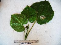 Octomeles sumatrana Miq. 923560[]Whitfeld, T.J.S. OA1C00382008-07-23 Papua New Guinea, Madang, Wanang Village, -5.233683 145.171867, 179m |
MIN:Plants | 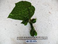 Octomeles sumatrana Miq. 920742[]Whitfeld, T.J.S. OD3D01312008-08-05 Papua New Guinea, Madang, Wanang Village, -5.230783 145.165833, 170m |
MIN:Plants | 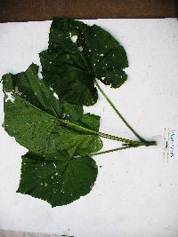 Octomeles sumatrana Miq. 923633[]Whitfeld, T.J.S. SB2E00932008-07-18 Papua New Guinea, Madang, Wanang Village, -5.242633 145.166733, 113m |
MIN:Plants | 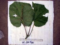 Octomeles sumatrana Miq. 913355[]Weiblen, G.D. & Binatang Research Center WS3B05002006-10-11 Papua New Guinea, Madang, Wanang Village, -5.229583 145.178467, 115m |
MIN:Plants | 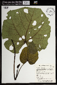 Octomeles sumatrana Miq. 965847[1356595]Whitfeld, T. J. S. 2083b2019-02-16 Papua New Guinea, Madang, Wanang Conservation Area, inside the Wanang 50 hectare Forest Dynamics Plot, -5.232975 145.07455, 150m |
MIN:Plants | 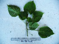 Tetrameles nudiflora R. Br. 921368[]Whitfeld, T.J.S. OA2B01092008-07-23 Papua New Guinea, Madang, Wanang Village, -5.233683 145.171867, 179m |
MIN:Plants | Tetrameles nudiflora R. Br. 913347[]Weiblen, G.D. & Binatang Research Center WS1Z32612008-04-23 Papua New Guinea, Madang, Wanang Village, -5.229583 145.178467, 115m |
MIN:Plants | 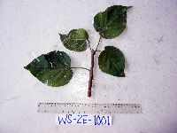 Tetrameles nudiflora R. Br. 913349[]Weiblen, G.D. & Binatang Research Center WS2E10012007-08-03 Papua New Guinea, Madang, Wanang Village, -5.229583 145.178467, 115m |
MIN:Plants | 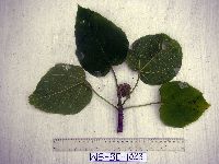 Tetrameles nudiflora R. Br. 913348[]Weiblen, G.D. & Binatang Research Center WS3E10232007-09-10 Papua New Guinea, Madang, Wanang Village, -5.229583 145.178467, 115m |
MIN:Plants | 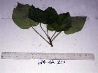 Tetrameles nudiflora R. Br. 913350[]Weiblen, G.D. & Binatang Research Center WS4A02172006-05-15 Papua New Guinea, Madang, Wanang Village, -5.229583 145.178467, 115m |
MIN:Plants | 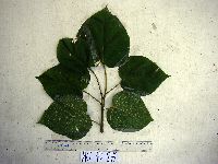 Tetrameles nudiflora R. Br. 913351[]Weiblen, G.D. & Binatang Research Center WS4D08712007-03-08 Papua New Guinea, Madang, Wanang Village, -5.229583 145.178467, 115m |
1
Page 1, records 1-11 of 11
Google Map
Google Maps is a web mapping service provided by Google that features a map that users can pan (by dragging the mouse) and zoom (by using the mouse wheel). Collection points are displayed as colored markers that when clicked on, displays the full information for that collection. When multiple species are queried (separated by semi-colons), different colored markers denote each individual species.