University of Minnesota
http://www.umn.edu/
612-625-5000
http://www.umn.edu/
612-625-5000
Minnesota Biodiversity Atlas
Bell Museum
Dataset: MIN-Plants
Taxa: Theaceae
Search Criteria: excluding cultivated/captive occurrences
1
Page 1, records 1-10 of 10
Bell Museum plants | |
 MIN:Plants | Schima wallichii Choisy 510870[]Univ. of Calif. Bot. Gard. list 18 - 1701976-00-00 China, Hong Kong, Hong Kong |
MIN:Plants | Gordonia lasianthus (L.) J. Ellis 510871[]US Nat. Arboretum staff 2111978-00-00 United States, Alabama, Mobile, Mobile Co.;;;;, 30.685147 -88.19753 |
MIN:Plants | 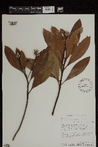 Gordonia lasianthus (L.) J. Ellis 432436[1299052]Merello, M.; et al. 3871992-09-20 United States, North Carolina, Craven, Craven County. South of New Bern Croatan national Forest. Along Forest Service Road 121-3 at dead end., 70m |
MIN:Plants | 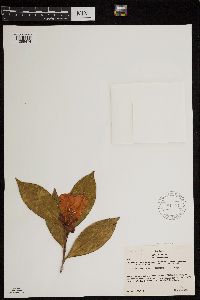 Camellia japonica NULL 581153[1299474]Kirino, Shuho 8751955-04-15 Japan, Honshu Island, Chubu District - Toyama Prefecture; Shime, Sasa-wara, in the town of Yatsuo, 19 kilomieters northwest of Toyama City;;;;, 36.5833333 137.1194444 |
MIN:Plants | 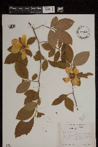 449429[1299051]Duncan, W. 60241944-05-11 United States, South Carolina, Dorchester, Dorchester County...On Middleton Tract. SW of Middleton Gardens about 15 mi. NW of Charleston. |
MIN:Plants | 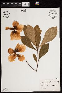 Franklinia alatamaha Marshall 484767[1299687]Abbott, Robinson s.n.1979-07-24 United States, United States; Pennsylvania, Philadelphia County ... cult. |
MIN:Plants | Franklinia alatamaha Marshall 510873[]US Nat. Arboretum staff 1901976-00-00 United States, Maryland, Montgomery Co. cultivated |
MIN:Plants | Gordonia axillaris (Roxbury ex Ker) Endlicher 510872[]Univ. of Calif. Bot. Gard. list 18 - 1691976-00-00 China, Hong Kong, Hong Kong |
MIN:Plants |  350498[1299712] China |
MIN:Plants |  Polyspora papuana (Kobuski) Orel, Peter G.Wilson, Curry & Luu 969957[1371560]Weiblen, G. D. & Binatang Research Center NP2B01432014-03-31 Papua New Guinea, Madang, Numba, -5.7222 145.2714, 1200m |
1
Page 1, records 1-10 of 10
Google Map
Google Maps is a web mapping service provided by Google that features a map that users can pan (by dragging the mouse) and zoom (by using the mouse wheel). Collection points are displayed as colored markers that when clicked on, displays the full information for that collection. When multiple species are queried (separated by semi-colons), different colored markers denote each individual species.