University of Minnesota
http://www.umn.edu/
612-625-5000
http://www.umn.edu/
612-625-5000
Minnesota Biodiversity Atlas
Bell Museum
Dataset: NGBRC
Taxa: Asteraceae
Search Criteria: excluding cultivated/captive occurrences
1
Page 1, records 1-8 of 8
Plant records from the New Guinea Binatang Research Center | |
 NGBRC | 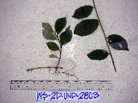 Microglossa pyrifolia (Lam.) Kuntze WS2D2803[]Binatang Research Center WS2D28032007-07-18 Papua New Guinea, Madang Province, Wanang, -5.229583 145.178467, 115m |
NGBRC | 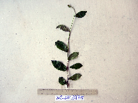 Vernonia lanceolata (Warb.) Mattf. WS2E2975[]Binatang Research Center WS2E29752008-09-23 Papua New Guinea, Madang Province, Wanang, -5.229583 145.178467, 115m |
NGBRC | 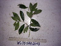 Vernonia lanceolata (Warb.) Mattf. WS3E3043[]Binatang Research Center WS3E30432008-09-23 Papua New Guinea, Madang Province, Wanang, -5.229583 145.178467, 115m |
NGBRC | 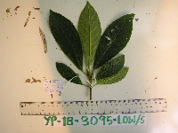 YP1B3095[]Binatang Research Center YP1B30952013-05-29 Papua New Guinea, Morobe Province, Yawan, -6.1637 146.842017, 1749m |
NGBRC | 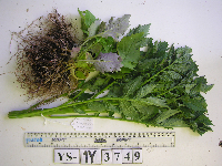 YS1Y3749[]Binatang Research Center YS1Y37492016-04-19 Papua New Guinea |
NGBRC | 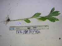 Conyza sumatrensis (Retz.) E. Walker YS1Y3750[]Binatang Research Center YS1Y37502021-07-10 Papua New Guinea |
NGBRC | 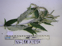 YS1X3778[]Binatang Research Center YS1X37782013-07-05 Papua New Guinea |
NGBRC | 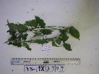 Mikania cordata (Burm.f.) B.L. Rob. YS1X3797[]Binatang Research Center YS1X37972013-07-05 Papua New Guinea |
1
Page 1, records 1-8 of 8
Google Map
Google Maps is a web mapping service provided by Google that features a map that users can pan (by dragging the mouse) and zoom (by using the mouse wheel). Collection points are displayed as colored markers that when clicked on, displays the full information for that collection. When multiple species are queried (separated by semi-colons), different colored markers denote each individual species.