University of Minnesota
http://www.umn.edu/
612-625-5000
http://www.umn.edu/
612-625-5000
Minnesota Biodiversity Atlas
Bell Museum
Dataset: NGBRC
Taxa: Dilleniaceae
Search Criteria: excluding cultivated/captive occurrences
1
Page 1, records 1-13 of 13
Plant records from the New Guinea Binatang Research Center | |
 NGBRC | Dillenia castaneifolia Martelli Ctvrtecka2017[]Ctvrtecka, R. 20172008-09-02 Papua New Guinea, Madang Province, Wanang, -5.23088 145.182, 115m |
NGBRC | 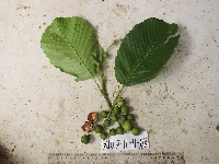 Dillenia castaneifolia Martelli Ctvrtecka3192[]Ctvrtecka, R. 31922008-11-11 Papua New Guinea, Madang Province, Wanang, -5.23088 145.182, 115m |
NGBRC | 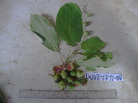 Dillenia castaneifolia Martelli Ctvrtecka3329[]Ctvrtecka, R. 33292008-11-17 Papua New Guinea, Madang Province, Wanang, -5.23088 145.182, 115m |
NGBRC | 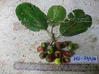 Dillenia castaneifolia Martelli Ctvrtecka3407[]Ctvrtecka, R. 34072008-11-24 Papua New Guinea, Madang Province, Wanang, -5.23088 145.182, 115m |
NGBRC | 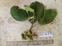 Dillenia castaneifolia Martelli Ctvrtecka3575[]Ctvrtecka, R. 35752008-12-03 Papua New Guinea, Madang Province, Wanang, -5.23088 145.182, 115m |
NGBRC | 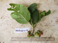 Dillenia castaneifolia Martelli Ctvrtecka3584[]Ctvrtecka, R. 35842008-12-04 Papua New Guinea, Madang Province, Wanang, -5.23088 145.182, 115m |
NGBRC | 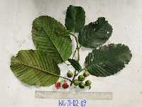 Dillenia castaneifolia Martelli Ctvrtecka4007[]Ctvrtecka, R. 40072009-02-11 Papua New Guinea, Madang Province, Wanang, -5.23088 145.182, 115m |
NGBRC | 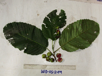 Dillenia castaneifolia Martelli Ctvrtecka3939[]Ctvrtecka, R. 39392009-02-05 Papua New Guinea, Madang Province, Wanang, -5.23088 145.182, 115m |
NGBRC | 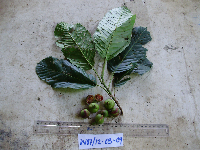 Dillenia castaneifolia Martelli Ctvrtecka4563[]Ctvrtecka, R. 45632009-03-12 Papua New Guinea, Madang Province, Wanang, -5.23088 145.182, 115m |
NGBRC | 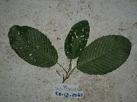 Dillenia castaneifolia Martelli SA1D0060[]Binatang Research Center SA1D00602008-07-14 Papua New Guinea, Madang Province, Wanang, -5.238167 145.170983, 73m |
NGBRC | Dillenia castaneifolia Martelli SA1E0063[]Binatang Research Center SA1E00632008-07-11 Papua New Guinea, Madang Province, Wanang, -5.238167 145.170983, 73m |
NGBRC | Dillenia castaneifolia Martelli SA1E0066[]Binatang Research Center SA1E00662008-07-11 Papua New Guinea, Madang Province, Wanang, -5.238167 145.170983, 73m |
NGBRC | 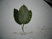 Dillenia montana Diels NP1A0013[]Binatang Research Center NP1A00132014-09-10 Papua New Guinea, Madang, Numba, -5.7222 145.2714, 1200m |
1
Page 1, records 1-13 of 13
Google Map
Google Maps is a web mapping service provided by Google that features a map that users can pan (by dragging the mouse) and zoom (by using the mouse wheel). Collection points are displayed as colored markers that when clicked on, displays the full information for that collection. When multiple species are queried (separated by semi-colons), different colored markers denote each individual species.