University of Minnesota
http://www.umn.edu/
612-625-5000
http://www.umn.edu/
612-625-5000
Minnesota Biodiversity Atlas
Bell Museum
Dataset: NGBRC
Taxa: Ericaceae
Search Criteria: excluding cultivated/captive occurrences
1
Page 1, records 1-12 of 12
Plant records from the New Guinea Binatang Research Center | |
 NGBRC | 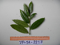 Dimorphanthera denticulifera Sleumer YP1A2217[]Binatang Research Center YP1A22172011-08-18 Papua New Guinea, Morobe Province, Yawan, -6.162617 146.841967, 1777m |
NGBRC | 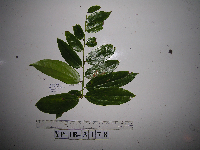 Dimorphanthera denticulifera Sleumer YP1B3178[]Binatang Research Center YP1B31782013-03-23 Papua New Guinea, Morobe Province, Yawan, -6.1637 146.842017, 1749m |
NGBRC |  Dimorphanthera denticulifera Sleumer YP2A2275[]Binatang Research Center YP2A22752011-08-18 Papua New Guinea, Morobe Province, Yawan, -6.162617 146.841967, 1777m |
NGBRC | 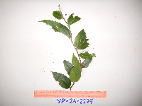 Dimorphanthera denticulifera Sleumer YP2A2279[]Binatang Research Center YP2A22792011-08-18 Papua New Guinea, Morobe Province, Yawan, -6.162617 146.841967, 1777m |
NGBRC | 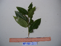 Dimorphanthera denticulifera Sleumer YP3A2331[]Binatang Research Center YP3A23312011-08-18 Papua New Guinea, Morobe Province, Yawan, -6.162617 146.841967, 1777m |
NGBRC | 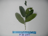 Dimorphanthera denticulifera Sleumer YP3A2350[]Binatang Research Center YP3A23502011-08-18 Papua New Guinea, Morobe Province, Yawan, -6.162617 146.841967, 1777m |
NGBRC | 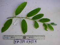 Dimorphanthera denticulifera Sleumer YP3B4025[]Binatang Research Center YP3B40252013-02-13 Papua New Guinea, Morobe Province, Yawan, -6.1637 146.842017, 1749m |
NGBRC | 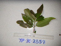 Dimorphanthera denticulifera Sleumer YP3C2859[]Binatang Research Center YP3C28592013-05-22 Papua New Guinea, Morobe Province, Yawan, -6.163017 146.842983, 1732m |
NGBRC | 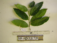 Dimorphanthera denticulifera Sleumer YP3D3679[]Binatang Research Center YP3D36792013-05-28 Papua New Guinea, Morobe Province, Yawan, -6.1642 146.840083, 1738m |
NGBRC | 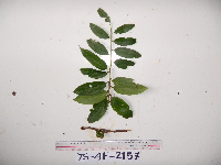 Dimorphanthera denticulifera Sleumer YS4F2157[]Binatang Research Center YS4F21572011-08-18 Papua New Guinea, Morobe Province, Yawan, -6.16255 146.839933, 1721m |
NGBRC | 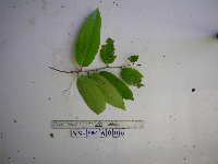 Dimorphanthera denticulifera Sleumer YS4K6006[]Binatang Research Center YS4K60062012-11-07 Papua New Guinea, Morobe Province, Yawan, -6.163883 146.838333, 1723m |
NGBRC | Dimorphanthera robbinsii Sleumer YP4C2772[]Binatang Research Center YP4C27722012-04-06 Papua New Guinea, Morobe Province, Yawan, -6.163017 146.842983, 1732m |
1
Page 1, records 1-12 of 12
Google Map
Google Maps is a web mapping service provided by Google that features a map that users can pan (by dragging the mouse) and zoom (by using the mouse wheel). Collection points are displayed as colored markers that when clicked on, displays the full information for that collection. When multiple species are queried (separated by semi-colons), different colored markers denote each individual species.