University of Minnesota
http://www.umn.edu/
612-625-5000
http://www.umn.edu/
612-625-5000
Minnesota Biodiversity Atlas
Bell Museum
Dataset: NGBRC
Taxa: Ochnaceae
Search Criteria: excluding cultivated/captive occurrences
1
Page 1, records 1-13 of 13
Plant records from the New Guinea Binatang Research Center | |
 NGBRC | 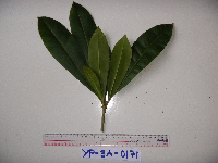 Schuurmansia henningsii K.Schum. YP3A0171[]Binatang Research Center YP3A01712011-03-18 Papua New Guinea, Morobe Province, Yawan, -6.162617 146.841967, 1777m |
NGBRC | 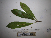 Schuurmansia henningsii K.Schum. YP3D0129[]Binatang Research Center YP3D01292012-08-09 Papua New Guinea, Morobe Province, Yawan, -6.1642 146.840083, 1738m |
NGBRC | 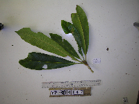 Schuurmansia henningsii K.Schum. YP3D0147[]Binatang Research Center YP3D01472012-08-13 Papua New Guinea, Morobe Province, Yawan, -6.1642 146.840083, 1738m |
NGBRC | 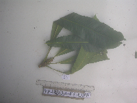 Schuurmansia henningsii K.Schum. YP3D3645[]Binatang Research Center YP3D36452012-08-07 Papua New Guinea, Morobe Province, Yawan, -6.1642 146.840083, 1738m |
NGBRC | 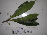 Schuurmansia henningsii K.Schum. YP4D0207[]Binatang Research Center YP4D02072013-04-18 Papua New Guinea, Morobe Province, Yawan, -6.1642 146.840083, 1738m |
NGBRC | 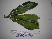 Schuurmansia henningsii K.Schum. YP4D0212[]Binatang Research Center YP4D02122012-08-25 Papua New Guinea, Morobe Province, Yawan, -6.1642 146.840083, 1738m |
NGBRC | 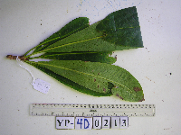 Schuurmansia henningsii K.Schum. YP4D0213[]Binatang Research Center YP4D02132013-03-24 Papua New Guinea, Morobe Province, Yawan, -6.1642 146.840083, 1738m |
NGBRC | 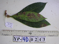 Schuurmansia henningsii K.Schum. YP4D0243[]Binatang Research Center YP4D02432013-02-20 Papua New Guinea, Morobe Province, Yawan, -6.1642 146.840083, 1738m |
NGBRC | 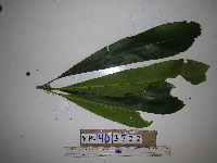 Schuurmansia henningsii K.Schum. YP4D3722[]Binatang Research Center YP4D37222013-05-29 Papua New Guinea, Morobe Province, Yawan, -6.1642 146.840083, 1738m |
NGBRC | 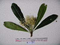 Schuurmansia henningsii K.Schum. YS1F0015[]Binatang Research Center YS1F00152011-03-19 Papua New Guinea, Morobe Province, Yawan, -6.16255 146.839933, 1721m |
NGBRC | 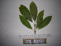 Schuurmansia henningsii K.Schum. YS1Z3356[]Binatang Research Center YS1Z33562013-01-09 Papua New Guinea |
NGBRC | 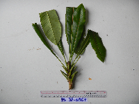 Schuurmansia henningsii K.Schum. YS3F0367[]Binatang Research Center YS3F03672011-05-19 Papua New Guinea, Morobe Province, Yawan, -6.16255 146.839933, 1721m |
NGBRC | 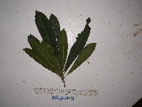 Schuurmansia elegans Blume NP1A0041[]Binatang Research Center NP1A00412014-06-03 Papua New Guinea, Madang, Numba, -5.7222 145.2714, 1200m |
1
Page 1, records 1-13 of 13
Google Map
Google Maps is a web mapping service provided by Google that features a map that users can pan (by dragging the mouse) and zoom (by using the mouse wheel). Collection points are displayed as colored markers that when clicked on, displays the full information for that collection. When multiple species are queried (separated by semi-colons), different colored markers denote each individual species.