University of Minnesota
http://www.umn.edu/
612-625-5000
http://www.umn.edu/
612-625-5000
Minnesota Biodiversity Atlas
Bell Museum
Dataset: NGBRC
Taxa: Pteridaceae
Search Criteria: excluding cultivated/captive occurrences
1
Page 1, records 1-7 of 7
Plant records from the New Guinea Binatang Research Center | |
 NGBRC | Antrophyum reticulatum (Forst.) Kaulf. YS1H3520[]Binatang Research Center YS1H35202015-10-22 Papua New Guinea, Morobe Province, Yawan, -6.1641 146.843567, 1851m |
NGBRC | 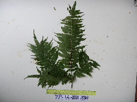 Pteris schlechteri Brause YP1A2180[]Binatang Research Center YP1A21802011-08-16 Papua New Guinea, Morobe Province, Yawan, -6.162617 146.841967, 1777m |
NGBRC | 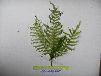 Pteris schlechteri Brause YP2A2249[]Binatang Research Center YP2A22492011-08-16 Papua New Guinea, Morobe Province, Yawan, -6.162617 146.841967, 1777m |
NGBRC | 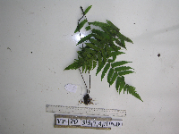 Pteris schlechteri Brause YP2D3574[]Binatang Research Center YP2D35742012-07-23 Papua New Guinea, Morobe Province, Yawan, -6.1642 146.840083, 1738m |
NGBRC | 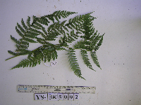 Pteris schlechteri Brause YS3K5002[]Binatang Research Center YS3K50022013-01-09 Papua New Guinea, Morobe Province, Yawan, -6.163883 146.838333, 1723m |
NGBRC | 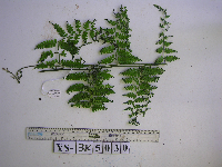 Pteris schlechteri Brause YS3K5030[]Binatang Research Center YS3K50302013-05-25 Papua New Guinea, Morobe Province, Yawan, -6.163883 146.838333, 1723m |
NGBRC | 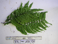 Pteris schlechteri Brause YS4K5071[]Binatang Research Center YS4K50712013-04-26 Papua New Guinea, Morobe Province, Yawan, -6.163883 146.838333, 1723m |
1
Page 1, records 1-7 of 7
Google Map
Google Maps is a web mapping service provided by Google that features a map that users can pan (by dragging the mouse) and zoom (by using the mouse wheel). Collection points are displayed as colored markers that when clicked on, displays the full information for that collection. When multiple species are queried (separated by semi-colons), different colored markers denote each individual species.