University of Minnesota
http://www.umn.edu/
612-625-5000
http://www.umn.edu/
612-625-5000
Minnesota Biodiversity Atlas
Bell Museum
Dataset: JFBM-Fishes
Taxa: Moronidae
Search Criteria: excluding cultivated/captive occurrences
Bell Museum fishes | |
 JFBM:Fishes | 41448[]Bartels, Andy United States, Minnesota, Winona, Detailed locality information protected. This is typically done to protect rare or threatened species localities. |
JFBM:Fishes | 9813[]Culler, Clarence United States, Iowa, Clayton, Detailed locality information protected. This is typically done to protect rare or threatened species localities. |
JFBM:Fishes | 9815[]Culler, Clarence United States, Iowa, Clayton, Detailed locality information protected. This is typically done to protect rare or threatened species localities. |
JFBM:Fishes | 17249[]Darnell, Rezneat; Suttkus, Royal United States, Louisiana, Orleans, Detailed locality information protected. This is typically done to protect rare or threatened species localities. |
JFBM:Fishes | 16698[]Baker, C.; Darnell, Rezneat United States, Tennessee, Lake, Detailed locality information protected. This is typically done to protect rare or threatened species localities. |
JFBM:Fishes | 9812[]Culler, Clarence United States, Iowa, Clayton, Detailed locality information protected. This is typically done to protect rare or threatened species localities. |
JFBM:Fishes | 45887[]D. Dieterman United States, Minnesota, Houston, Detailed locality information protected. This is typically done to protect rare or threatened species localities. |
JFBM:Fishes | 41447[]Bartels, Andy United States, Wisconsin, La Crosse, Detailed locality information protected. This is typically done to protect rare or threatened species localities. |
JFBM:Fishes | 40193[]Simons, Andrew; Egge, Jacob; Vincent, Donnie; Seroogy, Matthew United States, Arkansas, Grant, Detailed locality information protected. This is typically done to protect rare or threatened species localities. |
JFBM:Fishes | 9814[]Culler, Clarence United States, Iowa, Clayton, Detailed locality information protected. This is typically done to protect rare or threatened species localities. |
JFBM:Fishes | 9816[]Culler, Clarence United States, Iowa, Clayton, Detailed locality information protected. This is typically done to protect rare or threatened species localities. |
JFBM:Fishes |  39610[]Feist, Mike; Schmidt, Konrad 2001-08-20 United States, Minnesota, Nicollet, Minnesota River, ca. 2 miles upstream of County Road 14 |
JFBM:Fishes |  45191[]Kelly, Michael 2006-08-22 United States, Minnesota, Otter Tail, Otter Tail River, 1 mile E of Breken Ridge, ca. 2 miles upstream of Highway 9, 46.2672222 -96.5563889 |
JFBM:Fishes |  45221[]Niemela, Scott 2006-09-19 United States, Minnesota, Kittson, Red River of the North, access from Pembina, North Dakota, boat launch in Fort Daer Recreation Area, 48.96459856 -97.23317709 |
JFBM:Fishes |  45212[]Niemela, Scott 2006-09-07 United States, Minnesota, Polk, Red River of the North, upstream of Demers Avenue, in East Grand Forks, 47.9252778 -97.0252778 |
JFBM:Fishes |  42033[]Talmage, Phil 2002-06-17 United States, Minnesota, Wabasha, Zumbro River at boat access at park in Millville (Zumr 05) at River Mile 35.75, 44.2383333 -92.3061111 |
JFBM:Fishes |  9822[]Culler, Clarence 1938-11-28 United States, Iowa, Clayton, Mississippi River at Guttenberg, 42.78683 -91.08902 |
JFBM:Fishes | 43325[]Simons, Andrew; Gamble, Tony; Schmidt, Konrad 2003-10-24 United States, Minnesota, Ramsey/Hennepin/Dakota, Mississippi River below Ford Dam, 44.91455 -93.19981 |
JFBM:Fishes |  45160[]Kelly, Michael 2006-09-20 United States, Minnesota, Wilkin, Red River of the North, downstream of County Road 190, 3.5 miles NW of Wolverton, 46.60641871 -96.76847578 |
JFBM:Fishes |  41902[]Talmage, Phil 2002-07-24 United States, Minnesota, Dakota/Goodhue, Cannon River (station 03), downstream from county park, River Mile 18, 44.5402794 -92.8024979 |
JFBM:Fishes |  22020[]Pflieger, WIlliam 1963-09-25 United States, Missouri, Ralls, Mississippi River, 8.5 miles SE of Hannibal, 39.62883 -91.24369 |
JFBM:Fishes |  42002[]Talmage, Phil; Walerak, Mike; Hoffman, Brent 2002-08-13 United States, Minnesota, Olmsted, Middle Branch Zumbro River, 1 mile downstream from Oronoco dam at River Mile 71, 44.1577759 -92.5205536 |
JFBM:Fishes |  42047[]Talmage, Phil 2002-06-17 United States, Minnesota, Wabasha, Zumbro River at bridge access at Hammond (Zumr06) at River Mile 41, 44.2249985 -92.3755569 |
JFBM:Fishes |  45217[]Niemela, Scott 2006-09-07 United States, Minnesota, Douglas, Red River of the North, 1 mile W of Warren, at public boat launch, 48.19538723 -97.13722987 |
JFBM:Fishes |  41757[]Bartels, Andy 1989-08-14 United States, Wisconsin, La Crosse, Mississippi River, Pool 8, Interstate 90 Bay in E channel, River Mile 701.8, 3 miles NE of La Crescent, 43.8574982 -91.2588882 |
JFBM:Fishes |  41929[]Talmage, Phil; Walerak, Mike; Hoffman, Brent 2002-07-30 United States, Minnesota, Houston, Root River station 08, downstream of Highway 26 at River Mile 3, 3 miles E of Hokah, 43.7711105 -91.2897186 |
JFBM:Fishes | 43317[]Simons, Andrew; Gamble, Tony; Schmidt, Konrad 2003-10-24 United States, Minnesota, Ramsey/Hennepin/Dakota, Mississippi River below Ford Dam, 44.91455 -93.19981 |
JFBM:Fishes |  43816[]Proulx, Nicholas; Ostendorf, David; DeVore, Jayna 2004-09-15 United States, Minnesota, Carver/Scott, Minnesota River downstream of abandoned railroad bridge, 0.2 miles E of Carver, 44.7630539 -93.6213913 |
JFBM:Fishes |  21665[]Olson, David; Porter 1975-08-25 United States, Minnesota, Traverse, Bois de Sioux River, at County Road 10, White Rock Dam, 45.86159 -96.57299 |
JFBM:Fishes | 7264[] United States, Minnesota, Scott, Minnesota River, Shakopee, 44.80084 -93.52661 |
JFBM:Fishes |  7412[] 1898-08-29 United States, Minnesota, Goodhue, Lowe's Lake, Red Wing, 44.57775 -92.5351 |
JFBM:Fishes | 12892[]Anderson, Craig; Erickson, James 1976-08-04 United States, Minnesota, Wilkin, Otter Tail River at County Road 12, in Breckenridge, 46.26424 -96.59871 |
JFBM:Fishes | 9378[JFBM-FISH-0009378] 1976-07-25 United States, Wabasha, unspecified |
JFBM:Fishes |  27451[]Northern States Power Company Biologists 1976-06-24 United States, Minnesota, Goodhue, Mississippi River, Main Channel, Prairie Island, 44.62346 -92.62264 |
JFBM:Fishes | 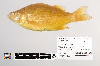 20599[]Kaercher, Roger 1970-10-22 United States, Minnesota, Dakota, Mississippi River at mouth of Minnesota River, 44.89691 -93.14911 |
JFBM:Fishes | 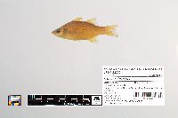 23220[]Wallmow, Rollo; McCormack, David 1985-09-03 United States, Minnesota, Wilkin, Rabbit River at County Road 9, 6 miles WNW of Campbell, 46.12132 -96.53412 |
JFBM:Fishes | 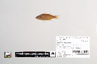 23431[]Wallmow, Rollo; McCormack 1985-07-30 United States, Minnesota, Wabasha, Zumbro River at U.S. Highway 61, 44.31193 -92.00363 |
JFBM:Fishes |  24083[]Hatch, Jay 1988-07-09 United States, Wisconsin, Buffalo, Mississippi River, River Mile 748, ca. 5 km NW of Buffalo City, 44.2755556 -91.8961111 |
JFBM:Fishes |  24098[]Hatch, Jay 1988-07-09 United States, Minnesota, Wabasha, Mississippi River at mouth of Zumbro River, 44.23511 -91.92329 |
JFBM:Fishes |  24102[]Hatch, Jay 1988-07-09 United States, Minnesota, Wabasha, Mississippi River at river mile 751, downstream of U.S. Lock and Dam Number 4, ca. 3 miles ENE of Kellogg, 44.31722 -91.92055 |
JFBM:Fishes |  24129[]Radke, Sue 1988-07-19 United States, Minnesota, Wabasha, Lake Pepin, S of Lake City, Mississippi River, 44.42495 -92.18765 |
JFBM:Fishes |  24272[]Minnesota Department of Natural Resources 1988-08-23 United States, Minnesota, Wabasha, Lake Pepin below Lake City, 44.42642 -92.19658 |
JFBM:Fishes |  7309[]Stoudt, J. 1935-12-00 United States, Minnesota, Dakota, Mississippi River, Hastings, 44.74686 -92.85147 |
JFBM:Fishes |  2820[]Nachtrieb, Henry 2000-08-13 United States, Wisconsin, Trempealeau, Mississippi River at Trempealeau, Wisconsin, 44.00121 -91.44505 |
JFBM:Fishes |  13916[] 1942-10-04 United States, Minnesota, Winona, Mississippi River, Whitman Pool (Pool 5), 44.16491 -91.81515 |
JFBM:Fishes |  2783[] Undefined, Undefined, no data, no data |
JFBM:Fishes |  11208[]Nachtrieb, Henry 1900-07-00 United States, Minnesota, Winona, Mississippi River, Minneiska, 44.2019 -91.86218 |
JFBM:Fishes |  9271[]Nachtrieb, Henry 1899-08-06 United States, Minnesota, Goodhue, Beyond Mud Lake, Red Wing, 44.57897 -92.50214 |
JFBM:Fishes |  7444[] 2000-08-04 United States, Wisconsin, Buffalo, Mississippi River, bay below Fountain City, 44.11779 -91.70134 |
JFBM:Fishes |  7415[] 1899-08-21 United States, Minnesota, Goodhue, Lowe's Lake, Red Wing, 44.56247 -92.5338 |
JFBM:Fishes |  7414[] 1899-08-00 United States, Minnesota, Goodhue, Mississippi River, at Red Wing, 44.57971 -92.51862 |
JFBM:Fishes |  2864[] 1899-08-09 United States, Minnesota, Mississippi River, Lake Pepin, 44.52001 -92.31262 |
JFBM:Fishes |  27850[]Schmidt, Konrad 1994-09-19 United States, Minnesota, Goodhue, Mississippi River, Pool 4, Lock and Dam 3, 44.61222 -92.6023 |
JFBM:Fishes |  27860[]Schmidt, Konrad 1994-09-19 United States, Minnesota, Goodhue, Mississippi River, Pool 4, Diamond Island, 44.60428 -92.58453 |
JFBM:Fishes |  27870[]Schmidt, Konrad 1994-09-13 United States, Minnesota, Houston, Mississippi River, Pool 9 at Twin Island, 43.53192 -91.24069 |
JFBM:Fishes |  27743[]United States Geological Survey; Minnesota Pollution Control Agency 1994-00-00 United States, Minnesota, Norman, Red River of the North at County Road 3, 2 miles W of Shelley, 47.4545 -96.85444 |
JFBM:Fishes |  27970[]Schmidt, Konrad 1994-09-14 United States, Minnesota, Houston, Mississippi River, Pool 8, Wildcat landing, 43.68662 -91.27218 |
JFBM:Fishes |  27960[]Schmidt, Konrad 1994-09-13 United States, Wisconsin, Vernon, Mississippi River at Willow Island, Pool 9, River Mile 678, 43.55079 -91.2394 |
JFBM:Fishes |  28021[]Hatch, Jay; Stopyro, Mark; Schmidt, Konrad 1995-04-07 United States, Minnesota, Wabasha, Mississippi River, Pool 5, middle of Island 42, N of Half Moon Lake and S of mouth of Zumbro River, 44.27974 -91.92381 |
JFBM:Fishes |  28218[]Goldstein 1995-08-08 United States, North Dakota, Ransom, Sheyenne River, N of Lisbon, 46.4472 -97.6815 |
JFBM:Fishes |  28342[]Pierzina, Doug 1995-09-21 United States, Minnesota, Traverse, Lake Traverse 78-25., 45.65053 -96.83144 |
JFBM:Fishes |  28719[]Enblom, Jack; Lee, Kathy 1996-08-19 United States, Minnesota, Carver, Minnesota River, across Highway 11 (formerly Highway 9) to Jordan, 44.69416 -93.64283 |
JFBM:Fishes |  32855[]Lee, Kathy; United States Geological Survey; National Water-Quality Assessment Program 1996-08-27 United States, Minnesota, Dakota, Mississippi River at USGS gauge at Hastings, below Lock & Dam 2, 44.7458333 -92.8541667 |
JFBM:Fishes |  33672[]Schmidt, Konrad 1997-09-23 United States, Minnesota, Chippewa, Lac Qui Parle Lake at Highway 40, Lac Qui Parle Wildlife Management Area, 45.09728 -95.98068 |
JFBM:Fishes |  33880[]Schmidt, Konrad 1997-09-29 United States, Minnesota, Lac Qui Parle, Lac Qui Parle Lake at end of County Road 68, Lac Qui Parle Wildlife Management Area, 45.12478 -96.02892 |
JFBM:Fishes |  33815[]Schmidt, Konrad 1997-09-23 United States, Minnesota, Lac Qui Parle, Minnesota River at State Highway 119, Lac Qui Parle Wildlife Management Area, 45.15928 -96.05415 |
JFBM:Fishes |  32842[]Lee, Kathy 1997-09-09 United States, Minnesota, Dakota, Mississippi River, at Hastings below lock and dam number 2, 44.76063 -92.86537 |
JFBM:Fishes |  30324[]Schmidt, Konrad 1998-07-25 United States, Minnesota, Hennepin, Minnesota River (old channel), 44.88817 -93.18071 |
JFBM:Fishes | 2819[] United States, Minnesota, No data |
JFBM:Fishes | 2821[] United States, Minnesota, No data |
JFBM:Fishes | 3582[] 1934-00-00 |
JFBM:Fishes |  33249[]Minnesota Pollution Control Agency 1999-10-01 United States, Minnesota, Washington, Mississippi River, Saint Paul Park, Pool 2, ca. 1 mile SW of Newport, 44.8606041 -93.00757654 |
JFBM:Fishes |  39190[]Feist, Mike; Schmidt, Konrad 2001-08-21 United States, Minnesota, Brown, Minnesota River downstream of section road 4, 8 miles N of Sleepy Eye, 44.4158325 -94.702774 |
JFBM:Fishes |  45219[]Niemela, Scott 2006-09-18 United States, Minnesota, Kittson, Red River of the North, at Hastings boat launch in Drayton, ND, 48.55885991 -97.17276753 |
JFBM:Fishes |  39442[]Talmage, Phil; Niemela, Scott 2001-08-21 United States, Minnesota, Lac Qui Parle, Lac Qui Parle River, 0.75 miles E of County Road 27 in County Park, 44.9980545 -95.9758301 |
JFBM:Fishes | 9820[]Culler, Clarence 1938-11-28 United States, Iowa, Clayton, Mississippi River at Guttenberg, 42.78683 -91.08902 |
JFBM:Fishes | 44886[]Johnson, T. 2006-07-02 United States, Minnesota, Pine, Cross Lake, NE of Pine City, 45.84985 -92.94159 |
JFBM:Fishes |  9819[]Culler, Clarence 1938-11-28 United States, Iowa, Clayton, Mississippi River at Guttenberg, 42.78683 -91.08902 |
JFBM:Fishes |  9817[]Culler, Clarence 1938-11-28 United States, Iowa, Clayton, Mississippi River at Guttenberg, 42.78683 -91.08902 |
JFBM:Fishes |  9821[]Culler, Clarence 1938-11-28 United States, Iowa, Clayton, Mississippi River at Guttenberg, 42.78683 -91.08902 |
JFBM:Fishes |  42060[]Talmage, Phil 2002-07-23 United States, Minnesota, Goodhue, Cannon River Station 01, downstream of Highway 61 bridge, River Mile 7, 44.5825005 -92.6449966 |
JFBM:Fishes |  45206[]Niemela, Scott 2006-09-06 United States, Minnesota, Wilkin, Red River of the North, downstream of County-State-Aid-Highway 22, 1.5 miles NE of Kent, in Fort Abercrombie State Historic Area, 46.44601143 -96.71890269 |
JFBM:Fishes |  39416[]Niemela, Scott; Schmidt, Konrad 2001-08-15 United States, Minnesota, Redwood, Redwood River downstream of E Oak Street, in Ramsey Park, in Redwood Falls, 44.55303725 -95.1238904 |
JFBM:Fishes |  39508[]Feist, Mike; Niemela, Scott 2001-09-06 United States, Minnesota, Nicollet, Minnesota River 2 miles upstream of County Road 42, 1 mile SW of Courtland, 44.2599983 -94.3577805 |
JFBM:Fishes |  9818[]Culler, Clarence 1938-11-28 United States, Iowa, Clayton, Mississippi River at Guttenberg, 42.78683 -91.08902 |
JFBM:Fishes |  19270[]Smith 1960-07-00 United States, Iowa, Muscatine, Mississippi River, Fairport, 41.43089 -90.90363 |
JFBM:Fishes |  45205[]Niemela, Scott 2006-09-05 United States, Minnesota, Wilkin, Red River of the North, just upstream of Breckenridge, boat access on North Dakota side of river in park visible from HIghway 210, 46.29173945 -96.59770196 |
JFBM:Fishes |  43973[]Niemela, Scott 2004-09-01 United States, Minnesota, Olmsted, South Fork Zumbro River at USGS Gauging Station, next to sewage disposal plant, N side of Rochester, 44.0783348 -92.4680557 |
JFBM:Fishes |  7397[] 2000-07-03 United States, Minnesota, Goodhue, Lake Pepin, upper end of the lake, 44.5458 -92.33185 |
JFBM:Fishes |  42043[]Talmage, Phil 2002-09-24 United States, Minnesota, Wabasha, Zumbro River at canoe access near Kellogg, 44.3133316 -91.9819412 |
JFBM:Fishes |  40451[]Feist, Mike; Niemela, Scott 2001-09-13 United States, Minnesota, Swift, Pomme de Terre River upstream of County Road 51, 2.5 miles W of Appleton, 45.1986122 -96.0738907 |
JFBM:Fishes | 12744[] 1940-11-00 United States, Minnesota, St. Croix River |
JFBM:Fishes | 12743[] 1940-11-00 United States, Minnesota, St. Croix River |
JFBM:Fishes | 12808[] 1940-00-00 United States, Minnesota, Washington, St. Croix River, Lake St. Croix, 44.78915 -92.78984 |
JFBM:Fishes | 9328[]Nachtrieb, Henry 2000-07-25 United States, Minnesota, Wabasha, Mississippi River sand bar, at Minnieska, 44.19365 -91.86819 |
JFBM:Fishes |  48291[]Feist, Mike 2014-09-03 United States, Minnesota, Scott, Minnesota River near Jordan, reach 1, 44.6946389 -93.6486111 |
JFBM:Fishes | 9430[]Carlander, Kenneth 1937-08-00 United States, Minnesota, Wabasha, Mississippi River, Wabasha, 44.38571 -92.03281 |
JFBM:Fishes | 48997[]Eder, Brandon 2017-07-12 United States, Minnesota, Rice, Roberds Lake (DOW 66-0018-00), Station 12, 44.330014 -93.36016 |
JFBM:Fishes |  19166[]Harmer, W. 1959-10-14 United States, Georgia, McIntosh, Butler Branch of Altamaha River, Couper's Bar, 5 miles above Darien, 31.37416 -81.5316 |
JFBM:Fishes |  19801[]Maxfield, Galen 1947-08-26 United States, Maryland, Charles, Potomac River, Colonial Beach, 38.27053 -76.93451 |
Google Map
Google Maps is a web mapping service provided by Google that features a map that users can pan (by dragging the mouse) and zoom (by using the mouse wheel). Collection points are displayed as colored markers that when clicked on, displays the full information for that collection. When multiple species are queried (separated by semi-colons), different colored markers denote each individual species.