University of Minnesota
http://www.umn.edu/
612-625-5000
http://www.umn.edu/
612-625-5000
Minnesota Biodiversity Atlas
Bell Museum
Dataset: JFBM-Fishes
Taxa: Osmeridae
Search Criteria: excluding cultivated/captive occurrences
1
Page 1, records 1-23 of 23
Bell Museum fishes | |
 JFBM:Fishes | 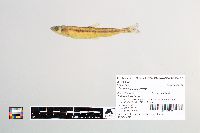 41892[]Schmidt, Konrad; Cholweth, G.; Evrard, L. 2003-05-13 United States, Wisconsin, Ashland, Lake Superior off Stockton Island (station 2 -serial #005) 27 miles NE of Ashland, 46.90759 -90.51361 |
JFBM:Fishes | 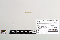 35887[]Bartels, Andy 1993-08-30 United States, Minnesota, Houston, Mississippi River at River Mile 691.7, 2.6 miles N of Brownsville, 43.7336121 -91.2577744 |
JFBM:Fishes | 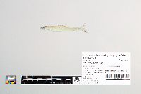 42584[]Schmidt, Konrad 2004-05-10 United States, Wisconsin, Ashland, Lake Superior, Apostle Islands, North Channel at North end of Madeline Island, 46.8697205 -90.5897217 |
JFBM:Fishes | 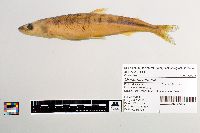 17033[]Gustafson, Ben 1947-04-11 United States, Minnesota, St. Louis, French River, at mouth, near Duluth, 46.89984 -91.89328 |
JFBM:Fishes |  19126[]Johnson, Ray 1946-12-07 United States, Minnesota, St. Louis, Lake Superior, off Duluth, 46.79254 -91.97754 |
JFBM:Fishes |  20711[]Bugge, M. 1972-07-21 United States, Minnesota, St. Louis, Lake Superior, 9 miles S of Knife River, and 6 miles out from shore, 46.85174 -91.80176 |
JFBM:Fishes |  23298[]Blackburn, Jamie; McCormack, David 1984-08-29 United States, Minnesota, Cook, Lake Superior, Double Bay (next bay north of Big Bay), 47.87145 -89.87606 |
JFBM:Fishes |  24333[]Minnesota Department of Natural Resources 1965-08-14 United States, Minnesota, Pine, Grindstone Lake, 46.12197 -93.00753 |
JFBM:Fishes | 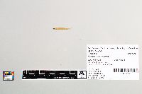 24499[]Schmidt, Konrad 1989-09-10 United States, Minnesota, Lake, Gooseberry River, 47.14224 -91.45676 |
JFBM:Fishes | 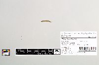 24708[]Blackburn, Jamie; McCormack, David 1984-08-29 United States, Minnesota, Cook, Lake Superior, Grand Portage Bay, 47.96167 -89.68333 |
JFBM:Fishes |  25862[]Etnier, David; Etnier, M.; Skelton, Christopher 1992-08-12 Canada, Ontario, Saganaga Lake at West Side Seagull Island, 48.22696 -90.9565 |
JFBM:Fishes | 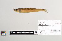 25932[]Ramon; Hagg 1979-07-25 United States, Minnesota, St. Louis, Burntside Lake, 47.9357 -91.9823 |
JFBM:Fishes | 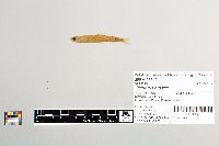 23310[]Blackburn, Jamie; McCormack, David 1984-06-19 United States, Minnesota, Lake, Beaver River at mouth, 47.25995 -91.2951 |
JFBM:Fishes | 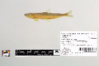 29475[]Schmidt, Konrad; Proulx, Nicholas 1998-04-22 United States, Minnesota, Cook, PIgeon River, above Minnesota Highway 61, 48.0021 -89.58664 |
JFBM:Fishes | 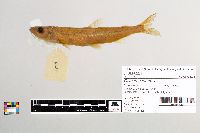 6221[]Elkins, W. 1934-07-17 United States, Vermont, Windsor, Echo Lake, just N of Tyson, 43.47273 -72.701 |
JFBM:Fishes | 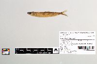 38607[]Ely Fisheries Area Office 1977-06-26 United States, Minnesota, St. Louis, Burntside Lake at Slim Creek and Tamarack Creek, 6 miles W of Ely, 47.89885 -92.05204 |
JFBM:Fishes | 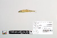 48182[]Hennen, Matt 2014-07-30 United States, Minnesota, Cook, Trout Lake (DOW 16-0049-00), Station #4, 47.8740378 -90.1801528 |
JFBM:Fishes |  48388[]Nagle, Brett; Spak, C. 2009-09-12 United States, Minnesota, Cook, Rose Lake, 48.09863 -90.42252 |
JFBM:Fishes | 48532[]Hennen, Matt 2015-08-04 United States, Minnesota, Cook, Trout Lake, 47.871204 -90.179812 |
JFBM:Fishes | 48533[]Hennen, Matt 2015-08-04 United States, Minnesota, Cook, Trout Lake, 47.866787 -90.176562 |
JFBM:Fishes |  12655[] 1942-04-00 United States, Wisconsin, Brown, Green Bay, Lake Michigan, 44.95702 -87.53906 |
JFBM:Fishes | 19085[]Minnesota Department of Conservation 1953-05-29 United States, Wisconsin, Ashland/Bayfield, Chequamegon Bay, Lake Superior, 46.65022 -90.84713 |
JFBM:Fishes | Hypomesus transpacificus McAllister 16409[]Woods, Don 1951-00-00 United States, California, San Joaquin River |
1
Page 1, records 1-23 of 23
Google Map
Google Maps is a web mapping service provided by Google that features a map that users can pan (by dragging the mouse) and zoom (by using the mouse wheel). Collection points are displayed as colored markers that when clicked on, displays the full information for that collection. When multiple species are queried (separated by semi-colons), different colored markers denote each individual species.