University of Minnesota
http://www.umn.edu/
612-625-5000
http://www.umn.edu/
612-625-5000
Minnesota Biodiversity Atlas
Dataset: MIN-Lichens
Search Criteria: United States OR USA OR U.S.A. OR United States of America; Michigan; Charlevoix; excluding cultivated/captive occurrences
1
Page 1, records 1-9 of 9
Bell Museum lichens | |
 MIN:Lichens | Trypethelium virens Tuck. 624620[]Imshaug, H. 274901961-08-26 United States, Michigan, Charlevoix, Beaver Island, Lake Geneserath, 45.597141 -85.537381 |
MIN:Lichens | Cetraria islandica (L.) Ach. 830810[]Imshaug, H. 275491961-08-26 United States, Michigan, Charlevoix, Beaver Island, North End Bay, 45.744324 -85.534647 |
MIN:Lichens | Julella sericea (A. Massal.) Coppins 838169[]Erbisch, F. 10791962-08-14 United States, Michigan, Charlevoix, East Jordan, 6 Mi Nw of |
MIN:Lichens | Caloplaca cerina (Hedw.) Th. Fr. 841967[]Imshaug, H. 278481961-08-30 United States, Michigan, Charlevoix, Beaver Island, Green Bay, 45.638635 -85.607161 |
MIN:Lichens | 887979[]Imshaug, H. 276821961-08-28 United States, Michigan, Charlevoix, Beaver Island, Iron Ore Bay, 45.57944444 -85.58944444 |
MIN:Lichens | Calicium trabinellum (Ach.) Ach. 894646[]Imshaug, H.A. 277251961-08-29 United States, Michigan, Charlevoix, Beaver Island, Barney Lake, 45.710923 -85.560138 |
MIN:Lichens | Caloplaca crenulatella (Nyl.) H. Olivier 902655[]Imshaug, H. 278561961-08-30 United States, Michigan, Charlevoix, Beaver Island, Green Ba, 45.664723 -85.557306 |
MIN:Lichens | Caloplaca crenulatella (Nyl.) H. Olivier 902656[]Imshaug, H. 278551961-08-30 United States, Michigan, Charlevoix, Beaver Island, Green Bay, 45.664723 -85.557306 |
MIN:Lichens | 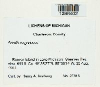 Buellia turgescens (Nyl.) Tuck. 956588[1288402]Imshaug, Henry A. 278151961-08-30 United States, Michigan, Charlevoix, Beaver Island in Lake Michigan. Greenes Bay, 45.640833 -85.603889, 183m |
1
Page 1, records 1-9 of 9
Google Map
Google Maps is a web mapping service provided by Google that features a map that users can pan (by dragging the mouse) and zoom (by using the mouse wheel). Collection points are displayed as colored markers that when clicked on, displays the full information for that collection. When multiple species are queried (separated by semi-colons), different colored markers denote each individual species.