University of Minnesota
http://www.umn.edu/
612-625-5000
http://www.umn.edu/
612-625-5000
Minnesota Biodiversity Atlas
Dataset: MIN-Lichens
Search Criteria: United States OR USA OR U.S.A. OR United States of America; Oregon; Deschutes; excluding cultivated/captive occurrences
1
Page 1, records 1-47 of 47
Bell Museum lichens | |
 MIN:Lichens | Letharia vulpina (L.) Hue 593148[]Ownbey s.n.1938-07-29 United States, Oregon, Deschutes, Cline Falls, 4 Mi W of |
MIN:Lichens | Letharia columbiana (Nutt.) J.W. Thomson 630859[]Tolstead, W. 128311942-06-06 United States, Oregon, Deschutes, Sisters, E of, 44.31 -121.47 |
MIN:Lichens | Letharia vulpina (L.) Hue 630873[]Tolstead, W. 128331942-06-06 United States, Oregon, Deschutes, Sisters, W of, 44.290949 -121.549212 |
MIN:Lichens | Letharia columbiana (Nutt.) J.W. Thomson 630875[]Tolstead, W. 128311942-06-06 United States, Oregon, Deschutes, Sisters, E of, 44.31 -121.47 |
MIN:Lichens | Letharia columbiana (Nutt.) J.W. Thomson 652132[]Tolstead, W. 128321942-06-06 United States, Oregon, Deschutes, Sisters, W of, 44.290949 -121.549212 |
MIN:Lichens | Amandinea punctata (Hoffm.) Coppins & Scheid. 652133[]Tolstead, W. 128341942-06-06 United States, Oregon, Deschutes, Sisters, E of, 44.31 -121.47 |
MIN:Lichens | Lecidea atrobrunnea (DC.) Schaer. 666511[]Tucker, S. 147411975-08-09 United States, Oregon, Deschutes, Sisters, 15 Mi S of; Deschutes National Forest, 44.10397 -121.62432 |
MIN:Lichens | Letharia vulpina (L.) Hue 668155[]Tolstead, W. 128321942-06-06 United States, Oregon, Deschutes, Sisters, E of, 44.290949 -121.549212 |
MIN:Lichens | Physcia cascadensis H. Magn. 693503[]Sherwood, M. s.n.1978-08-15 United States, Oregon, Deschutes, Sisters, 7 Mi E of, Highway 20 |
MIN:Lichens | 704043[]Sherwood, M.A. s.n.1978-08-15 United States, Oregon, Deschutes, Juniper Wayside, Highwy 20, 7 mi. E of Sisters., 884m |
MIN:Lichens | Letharia vulpina (L.) Hue 704044[]Sherwood, M. s.n.1978-08-15 United States, Oregon, Deschutes, Sisters, 7 Mi E of, Highway 20 |
MIN:Lichens | Aspicilia contorta (Hoffm.) Körb. 704046[]Sherwood, M. s.n.1978-08-15 United States, Oregon, Deschutes, Sisters, 7 Mi E of, Highway 20 |
MIN:Lichens | Rhizoplaca melanophthalma (DC.) Leuckert 704049[]Sherwood, M. s.n.1978-08-15 United States, Oregon, Deschutes, Sisters, 7 Mi E of, Highway 20 |
MIN:Lichens | 704050[]Sherwood, M. A. s.n.1978-08-15 United States, Oregon, Deschutes, Juniper Wayside, Hwy 20, 7 mi E of Sisters, 884m |
MIN:Lichens | Diploschistes muscorum (Scop.) R. Sant. 704051[]Sherwood, M. s.n.1978-08-15 United States, Oregon, Deschutes, Sisters, 7 Mi S of, Highway 20 |
MIN:Lichens | Ochrolechia upsaliensis (L.) A. Massal. 704056[]Sherwood, M. s.n.1978-08-15 United States, Oregon, Deschutes, Sisters, 7 Mi E of, Highway 20 |
MIN:Lichens | Buellia triseptata A. Nordin 704057[]Sherwood, M. s.n.1978-08-15 United States, Oregon, Deschutes, Sisters, 7 Mi E of , Highway 20 |
MIN:Lichens | 704060[]Sherwood, M. s.n.1978-08-15 United States, Oregon, Deschutes, Sisters, 7 Mi E of, Highway 20 |
MIN:Lichens | Letharia columbiana (Nutt.) J.W. Thomson 744061[]Ireland, O. 12141938-07-01 United States, Oregon, Deschutes, Between Sisters And Redmond |
MIN:Lichens | Letharia vulpina (L.) Hue 744085[]Sipe, F. s.n.1938-10-00 United States, Oregon, Deschutes, Near Sisters |
MIN:Lichens | Hypogymnia imshaugii Krog 821850[]Wilson, B. 4186C1990-08-09 United States, Oregon, Deschutes, 3-Creek Lake,S15,T17S,R9E |
MIN:Lichens | Xanthomendoza fulva (Hoffm.) Søchting, Kärnefelt & S.Y. Kondr. 873536[]Lindblom, L. 1731993-06-07 United States, Oregon, Deschutes, 8 Km N of Bend; Tumalo State Park, 44.11666667 -121.3333333 |
MIN:Lichens | Rhizoplaca melanophthalma (DC.) Leuckert 891637[]Wetmore, C. 950632006-07-18 United States, Oregon, Deschutes, 6 Mi W of Redmond, 44.29222222 -121.3197222 |
MIN:Lichens | Caloplaca arenaria (Pers.) Müll. Arg. 891638[]Wetmore, C. 950612006-07-18 United States, Oregon, Deschutes, 6 Mi W of Redmond, 44.29222222 -121.3197222 |
MIN:Lichens | Buellia badia (Fr.) A. Massal. 891639[]Wetmore, C. 950572006-07-18 United States, Oregon, Deschutes, 6 Mi W of Redmond, 44.29222222 -121.3197222 |
MIN:Lichens | Candelariella efflorescens R.C. Harris & W.R. Buck 891640[]Wetmore, C. 950562006-07-18 United States, Oregon, Deschutes, 6 Mi W of Redmond, 44.29222222 -121.3197222 |
MIN:Lichens | Caloplaca cerina (Hedw.) Th. Fr. 891641[]Wetmore, C. 950542006-07-17 United States, Oregon, Deschutes, Indian Falls Campground; Deschutes National Forest, 44.3575 -121.6088889 |
MIN:Lichens | Caloplaca holocarpa (Hoffm.) A.E. Wade 891642[]Wetmore, C. 950532006-07-17 United States, Oregon, Deschutes, Indian Falls Campground; Deschutes National Forest, 44.3575 -121.6088889 |
MIN:Lichens | Candelariella lutella (Vain.) Räsänen 891643[]Wetmore, C. 950472006-07-17 United States, Oregon, Deschutes, Indian Falls Campground; Deschutes National Forest, 44.3575 -121.6088889 |
MIN:Lichens | Letharia columbiana (Nutt.) J.W. Thomson 892054[]Wetmore, C. 950652006-07-18 United States, Oregon, Deschutes, 6 Mi W of Redmond, 44.29222222 -121.3197222 |
MIN:Lichens | 892055[]Wetmore, C. 950622006-07-18 United States, Oregon, Deschutes, 6 Mi W of Redmond, 44.29222222 -121.3197222 |
MIN:Lichens | Cladonia chlorophaea (Flörke ex Sommerf.) Spreng. 892056[]Wetmore, C. 950602006-07-18 United States, Oregon, Deschutes, 6 Mi W of Redmond, 44.29222222 -121.3197222 |
MIN:Lichens | Letharia vulpina (L.) Hue 892057[]Wetmore, C. 950522006-07-17 United States, Oregon, Deschutes, Indian Falls Campground; Deschutes National Forest, 44.3575 -121.6088889 |
MIN:Lichens | Letharia columbiana (Nutt.) J.W. Thomson 892058[]Wetmore, C. 950502006-07-17 United States, Oregon, Deschutes, Indian Falls Campground; Deschutes National Forest, 44.3575 -121.6088889 |
MIN:Lichens | Hypogymnia imshaugii Krog 892059[]Wetmore, C. 950482006-07-17 United States, Oregon, Deschutes, Indian Falls Campground; Deschutes National Forest, 44.3575 -121.6088889 |
MIN:Lichens | Cetraria canadensis (Räsänen) Räsänen 892060[]Wetmore, C. 950442006-07-17 United States, Oregon, Deschutes, Indian Falls Campground; Deschutes National Forest, 44.3575 -121.6088889 |
MIN:Lichens | 892061[]Wetmore, C. 950422006-07-17 United States, Oregon, Deschutes, Indian Falls Campground; Deschutes National Forest, 44.3575 -121.6088889 |
MIN:Lichens | Cetraria platyphylla Tuck. 892062[]Wetmore, C. 950412006-07-17 United States, Oregon, Deschutes, Indian Falls Campground; Deschutes National Forest, 44.3575 -121.6088889 |
MIN:Lichens | Parmotrema crinitum (Ach.) M. Choisy 892063[]Wetmore, C. 950402006-07-17 United States, Oregon, Deschutes, Indian Falls Campground; Deschutes National Forest, 44.3575 -121.6088889 |
MIN:Lichens | Parmelia sulcata Taylor 892064[]Wetmore, C. 950382006-07-17 United States, Oregon, Deschutes, Indian Falls Campground; Deschutes National Forest, 44.3575 -121.6088889 |
MIN:Lichens | Lecidella euphorea (Flörke) Hertel 895509[]Wetmore, C. 950462006-07-17 United States, Oregon, Deschutes, Indian Falls Campground; Deschutes National Forest, 44.3575 -121.6088889 |
MIN:Lichens | Lecanora laxa (Sliwa & Wetmore) Printzen 895510[]Wetmore, C. 950392006-07-17 United States, Oregon, Deschutes, Indian Falls Campground; Deschutes National Forest, 44.3575 -121.6088889 |
MIN:Lichens | Xanthomendoza fulva (Hoffm.) Søchting, Kärnefelt & S.Y. Kondr. 906774[]Wetmore, C. 950582006-07-18 United States, Oregon, Deschutes, 6 Mi W of Redmond, 44.29222222 -121.3197222 |
MIN:Lichens | Lecidea plana Kremp. 909312[]Wetmore, C. 950642006-07-18 United States, Oregon, Deschutes, 6 Mi W of Redmond, 44.29222222 -121.3197222 |
MIN:Lichens | Rhizoplaca phaedrophthalma (Poelt) Leavitt, Zhao Xin & Lumbsch 928360[]Wetmore, C. 950592006-07-18 United States, Oregon, Deschutes, Redmond, 6 Mi W, 44.2922222 -121.3197222 |
MIN:Lichens | 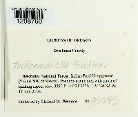 Nephromopsis fendleri (Nyl.) Divakar, A. Crespo & Lumbsch 957983[1298760]Clifford M Wetmore 950452006-07-17 United States, Oregon, Deschutes, Indian Falls Campground; Deschutes National Forest, 44.3575 -121.6088889, 991m |
MIN:Lichens | 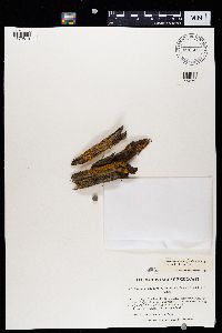 Xanthomendoza fulva (Hoffm.) Søchting, Kärnefelt & S.Y. Kondr. 906665[1370819]Wetmore, C.M. United States, Oregon, Deschutes |
1
Page 1, records 1-47 of 47
Google Map
Google Maps is a web mapping service provided by Google that features a map that users can pan (by dragging the mouse) and zoom (by using the mouse wheel). Collection points are displayed as colored markers that when clicked on, displays the full information for that collection. When multiple species are queried (separated by semi-colons), different colored markers denote each individual species.