University of Minnesota
http://www.umn.edu/
612-625-5000
http://www.umn.edu/
612-625-5000
Minnesota Biodiversity Atlas
Bell Museum
Dataset: MIN-Lichens
Search Criteria: United States OR USA OR U.S.A. OR United States of America; Texas; Val Verde; excluding cultivated/captive occurrences
1
Page 1, records 1-23 of 23
Bell Museum lichens | |
 MIN:Lichens | 020459[]Derstine, K. 10681979-04-09 United States, Texas, Val Verde, Langtry, 4 Mi W of, 29.808519 -101.625653 |
MIN:Lichens | 756523[]Derstine, K. 10691979-04-09 United States, Texas, Val Verde, Langtry, 4 Mi W, 29.808519 -101.625653 |
MIN:Lichens | 788710[]Derstine, K. 10691979-04-09 United States, Texas, Val Verde, Langtry, 4 Mi W of, 29.808519 -101.625653 |
MIN:Lichens | Psora russellii (Tuck.) A. Schneid. 788800[]Derstine, K. 10681979-04-09 United States, Texas, Val Verde, Langtry, 4 Mi W of, 29.808519 -101.625653 |
MIN:Lichens | 822340[]Hopkins, T. 4741976-06-05 United States, Texas, Val Verde, 14 Mi W of Loma Alta |
MIN:Lichens | Dermatocarpon miniatum (L.) W. Mann 822341[]Hopkins, T. 4231976-05-18 United States, Texas, Val Verde, 14 Mi W of Loma Alta |
MIN:Lichens | Physcia aipolia (Ehrh. Ex Humb.) Fürnr. 823117[]Hopkins, T. 4501976-06-04 United States, Texas, Val Verde, 14 Mi W of Loma Alta |
MIN:Lichens | Dermatocarpon americanum Vain. 832649[]Dowell, K. s.n.1993-08-22 United States, Texas, Val Verde, Near Comstock; Amistad National Recreation Area |
MIN:Lichens | Caloplaca appressa Wetmore & Kärnefelt 832653[]Dowell, K. s.n.1993-08-22 United States, Texas, Val Verde, Near Comstock; Amistad Recreation Area |
MIN:Lichens | Caloplaca eugyra (Tuck.) Zahlbr. 832663[]Dowell, K. s.n.1993-08-22 United States, Texas, Val Verde, Near Comstock; Amistad National Recreation Area |
MIN:Lichens | Caloplaca eugyra (Tuck.) Zahlbr. 854012[]Hopkins, T. 4771976-06-05 United States, Texas, Val Verde, 14 Mi W of Loma Alta |
MIN:Lichens | Caloplaca eugyra (Tuck.) Zahlbr. 858248[]Hopkins, T. s.n.1976-05-18 United States, Texas, Val Verde, 14 Mi W of Loma Alta |
MIN:Lichens | Caloplaca eugyra (Tuck.) Zahlbr. 858249[]Hopkins, T. 4291976-05-18 United States, Texas, Val Verde, 14 Mi W of Loma Alta |
MIN:Lichens | Caloplaca eugyra (Tuck.) Zahlbr. 858250[]Hopkins, T. 4271976-05-18 United States, Texas, Val Verde, 14 Mi W of Loma Alta |
MIN:Lichens | Punctelia bolliana (Müll. Arg.) Krog 875708[]Hopkins, T. 4491976-06-04 United States, Texas, Val Verde, 14 Mi W of Loma Alta, 29.885879 -100.992934 |
MIN:Lichens | Caloplaca subsoluta (Nyl.) Zahlbr. 882311[]Ryan, B. 327041996-12-16 United States, Texas, Val Verde, 2-3 km S of Headquarters; Seminole Canyon State Park, 29.68333333 -101.3083333 |
MIN:Lichens | Caloplaca appressa Wetmore & Kärnefelt 882312[]Ryan, B. 327141996-12-16 United States, Texas, Val Verde, 2-3 km S of Headquarters; Seminole Canyon State Park, 29.68333333 -101.3083333 |
MIN:Lichens | Parmotrema austrosinense (Zahlbr.) Hale 894665[]Hopkins, T.R. 4711976-06-05 United States, Texas, Val Verde, Loma Alta, 14 Mi. W, Near Juncture of Devil'S River & Dolan Creek |
MIN:Lichens | 894666[]Hopkins, T.R. 4331976-05-18 United States, Texas, Val Verde, Loma Alta, 14 Mi. W, Near Juncture of Devil'S River & Dolan Creek |
MIN:Lichens | Lecanora marginata (Schaerer) Hertel & Rambold 917440[]Dowell, K. s.n.1993-08-22 United States, Texas, Val Verde, Near Comstock; Amistad National Recreation Area |
MIN:Lichens | Haematomma fenzlianum A. Massal. 941353[]Hopkins, T. 4281976-05-18 United States, Texas, Val Verde, 14 Mi W of Loma Alta Near Juncture of The Devils River & Dolan Creek |
MIN:Lichens | 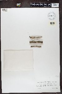 Lecanora glabrata (Ach.) Malme 655982[1370043]Goree United States, Texas, Val Verde |
MIN:Lichens | 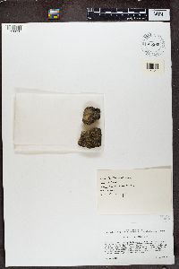 655969[1370056]Weber, W.A. United States, Texas, Val Verde |
1
Page 1, records 1-23 of 23
Google Map
Google Maps is a web mapping service provided by Google that features a map that users can pan (by dragging the mouse) and zoom (by using the mouse wheel). Collection points are displayed as colored markers that when clicked on, displays the full information for that collection. When multiple species are queried (separated by semi-colons), different colored markers denote each individual species.