University of Minnesota
http://www.umn.edu/
612-625-5000
http://www.umn.edu/
612-625-5000
Minnesota Biodiversity Atlas
Bell Museum
Dataset: MIN-Plants
Search Criteria: Mexico; excluding cultivated/captive occurrences
Bell Museum plants | |
 MIN:Plants | Bletia macristhmochila Greenm. 92033[1304054]Pringle, C.G. Mexico, Jalisco, Detailed locality information protected. This is typically done to protect rare or threatened species localities. |
MIN:Plants | Bletia reflexa Lindl. 92029[1304055]Pringle, C.G. Mexico, Michoacan, Detailed locality information protected. This is typically done to protect rare or threatened species localities. |
MIN:Plants | Bletia reflexa Lindl. 558808[1304056]Pringle, C.G. Mexico, Federal District, Detailed locality information protected. This is typically done to protect rare or threatened species localities. |
MIN:Plants | Bletia reflexa Lindl. 92035[1304057]Pringle, C.G. Mexico, Morelos, Detailed locality information protected. This is typically done to protect rare or threatened species localities. |
MIN:Plants | Bletia rosea (Lindl.) Dressler 92024[1304060]Pringle, C.G. Mexico, Jalisco, Detailed locality information protected. This is typically done to protect rare or threatened species localities. |
MIN:Plants | Bletia rosea (Lindl.) Dressler 507027[1304061]Ownbey, G.B. Mexico, Durango, Detailed locality information protected. This is typically done to protect rare or threatened species localities. |
MIN:Plants | Bletia secunda Lindl. 92037[1304062]Pringle, C.G. Mexico, Jalisco, Detailed locality information protected. This is typically done to protect rare or threatened species localities. |
MIN:Plants | Brachystele polyantha (Kuntze) Burns-Bal. 92848[1304065]Pringle, C.G. Mexico, Federal District, Detailed locality information protected. This is typically done to protect rare or threatened species localities. |
MIN:Plants | Brachystele sarcoglossa (A.Rich. & Galeotti) Burns-Bal. 92898[1304066]Pringle, C.G. Mexico, Oaxaca, Detailed locality information protected. This is typically done to protect rare or threatened species localities. |
MIN:Plants | Bletia rosea (Lindl.) Dressler 958945[1304059]Ownbey, G.B. Mexico, Durango, Detailed locality information protected. This is typically done to protect rare or threatened species localities. |
MIN:Plants |  Adiantum glaucophyllum Hook. 558851[1303347]Pringle, C.G. 156381909-02-20 Mexico, Mexico, 2591m |
MIN:Plants |  Adiantum glaucophyllum Hook. 50700[1303348]Pringle, C.G. 89711904-04-14 Mexico, 2316m |
MIN:Plants |  50666[1303351]Pringle, C.G. 4681885-04-24 Mexico, Chihuahua, Wet limestone ledges near Chihuahua, 28.882378 -106.412804 |
MIN:Plants |  50667[1303352]Smith, Jared G. 93 Mexico, Veracruz |
MIN:Plants |  Adiantum concinnum Humb. & Bonpl. ex Willd. 558782[1303354]Pringle, C.G. 157151909-10-11 Mexico, Morelos, Coal banks near Cuernavaca, 18.933725 -99.228488, 1524m |
MIN:Plants |  Adiantum concinnum Humb. & Bonpl. ex Willd. 292930[1303357]Mexia, Ynes 5341926-09-10 Mexico, Nayarit, Road from Tepic to Los Aguacotes, 21.509505 -104.895691, 1000m |
MIN:Plants |  Adiantum gracillimum T.Moore 50702[1303375]Murray, A. s.n. Mexico |
MIN:Plants |  Adiantum latifolium Lam. 50706[1303382]Smith, Jared G. 86 Mexico, Minatitlan, Mexico, 23.100767 -102.150391 |
MIN:Plants |  366035[1303388]Hinton, Geo. B. 108111937-10-16 Mexico, Nuevo León, Florida, 25.472716 -99.923574, 800m |
MIN:Plants |  Adiantum patens Willd. 303757[1303395]Mexia, Ynes 6041926-09-15 Mexico, Nayarit, Road from Tepic to Jalcojotan, 21.509505 -104.895691, 1000m |
MIN:Plants |  Adiantum poiretii Wikstr. 281154[1303400]Pringle, C.G. 117701903-11-15 Mexico, Eslaba, 23.100767 -102.150391 |
MIN:Plants |  Adiantum poiretii Wikstr. 292904[1303401]Mexia, Ynes 17741927-02-27 Mexico, Jalisco, Real Alto, Trail to San Sebastian, below La Bufa, 21.439709 -102.351522, 2000m |
MIN:Plants |  Adiantum tenerum Sw. 295284[1303417]Ortega, Jesus Gonzalez 71201932-09-00 Mexico, 2m |
MIN:Plants |  Adiantum tenerum Sw. 295218[1303418]Ortega, Jesus Gonzalez 68821931-03-00 Mexico, Las Breas, 26.75313 -107.991, 1200m |
MIN:Plants |  Adiantum tetraphyllum Humb. & Bonpl. ex Willd. 296865[1303424]Ortega, Jesus Gonzalez 66571926-12-00 Mexico, Nayarit, Mina Esperanza, 21.65 -104.7, 300m |
MIN:Plants |  279835[1303426]Mexia, Ynes 19071926-03-20 Mexico, Nayarit, Arroyo del Triangulo, Sierra Madre Mtns., 25 -105, 1425m |
MIN:Plants | 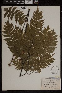 50826[1303431]Pringle, C.G. 39601891-12-01 Mexico, San Luis Potosi, Coffee plantation, Hacienda of Tamasopo, 21.950323 -99.243761 |
MIN:Plants | 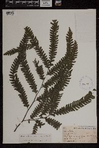 Adiantum wilesianum Hook. 50637[1303437]Smith, Jared G. 641892-00-00 Mexico |
MIN:Plants | 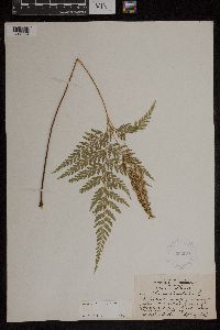 Anemia adiantifolia (L.) Sw. 354164[1303564]White, S. 2161927-09-06 Mexico, Nuevo Leon, 10 or 15 miles south of Monterrey, 25.555599 -100.16838 |
MIN:Plants | 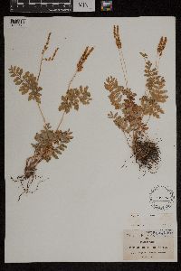 Anemia hirsuta (L.) Sw. 50496[1303571]Pringle,C.G. 38501891-09-15 Mexico, Jalisco, Near Guadalajara |
MIN:Plants |  Anemia hirsuta (L.) Sw. 558858[1303572]Pringle,C.G. 157091909-10-11 Mexico, Morelos, Near Cuernacaca, 1524m |
MIN:Plants |  Anemia hirsuta (L.) Sw. 50497[1303575]Pringle,C.G. 87921903-09-08 Mexico, Morelos, Near Cuernavaca |
MIN:Plants |  Anemia mexicana Klotzsch 635480[1303576]Taylor, John 124511972-12-27 Mexico, Neuvo Leon, 65 km NW of Monterrey, 28.999257 -105.711683, 914m |
MIN:Plants |  Anemia mexicana Klotzsch 50502[1303577]Pringle,C.G. 86951902-10-20 Mexico, Morelos, Near Yantepec, 1372m |
MIN:Plants | 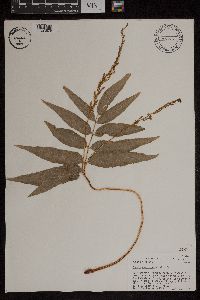 Anemia phyllitidis (L.) Sw. 471808[1303579]Lehto, E. 58531977-08-02 Mexico, Veracruz, Deep canyon along Rio San Antonio (toll road bridge over canyon and railroad on upper slopes of west), 1.3 miles west of Fortin (Plaza), 914m |
MIN:Plants | 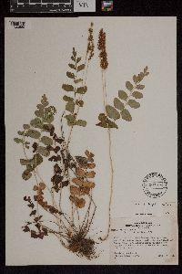 Anemia oblongifolia (Cav.) Sw. 507016[1303580]Ownbey, Gerald B. 18911953-09-26 Mexico, Sinaloa: Road between Durango, Dg, and Villa Union, Sin, 34.2 miles northeast of Villa Union, 914m |
MIN:Plants |  Anogramma Link 52757[1303621]Pringle, C.G. 14461887-09-10 Mexico, Chihuahua, near Guerrero, 28.882378 -106.412804 |
MIN:Plants |  Anogramma leptophylla (L.) Link 507012[1303622]Ownbey, Findley 19461953-09-28 Mexico, Durango, Durango, Road between Durango, Dgo, and Villa Union, Sin.; 60 miles southwest of El Salto, Dgo. (2.8 miles n.e. of El Paraiso, Sin.), 23.100767 -102.150391, 2073m |
MIN:Plants |  Anogramma chaerophylla (Desv) Link. 279832[1303623]unknown 13981927-01-05 Mexico, Jalisco, San Sebastian, Arroyo del Cura; Sierra Madre Occidental, 21.439709 -102.351522, 1425m |
MIN:Plants |  Aspidium trifoliatum (L.) Sw. 52689[1303684]Smith, Jared G. 621892-00-00 Mexico, Veracruz |
MIN:Plants | Corallorhiza ehrenbergii Rchb.f. 92143[1306549]Pringle, C.G. Mexico, Oaxaca, Valles Centrales, Detailed locality information protected. This is typically done to protect rare or threatened species localities. |
MIN:Plants | Corallorhiza mexicana Lindl. 959097[1306550]Pringle, C.G. Mexico, Oaxaca, Valles Centrales, Detailed locality information protected. This is typically done to protect rare or threatened species localities. |
MIN:Plants | Corallorhiza mexicana Lindl. 339743[1306551]Pringle, C.G. Mexico, Oaxaca, Valles Centrales, Detailed locality information protected. This is typically done to protect rare or threatened species localities. |
MIN:Plants | Cranichis Sw. 92279[1306575]Pringle, C. G. Mexico, Oaxaca, Detailed locality information protected. This is typically done to protect rare or threatened species localities. |
MIN:Plants | Cyclopogon pringlei (S.Watson) Soto Arenas 92856[1306578]Pringle, C. G. Mexico, Jalisco, Detailed locality information protected. This is typically done to protect rare or threatened species localities. |
MIN:Plants | Cyclopogon saccatus (A.Rich. & Galeotti) Schltr. 92857[1306579]Pringle, C. G. Mexico, Vera Cruz, Detailed locality information protected. This is typically done to protect rare or threatened species localities. |
MIN:Plants |  Asplenium L. 50846[1307222]Murray, Alex s.n. Mexico, [no further info], 21.515239 -101.476563 |
MIN:Plants |  558857[1307226]Pringle, C.G. 157121909-10-03 Mexico, mountain canyon above Cuernavaca, 18.282246 -101.327922, 1981m |
MIN:Plants | 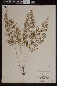 50869[1307227]Pringle, C.G. 89551904-07-21 Mexico, Morelos, mountain canyon above Cuernavaca, 18.933725 -99.228488, 1981m |
MIN:Plants | 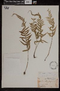 51051[1307230]Smith, Jared G. 741892-01-00 Mexico, Orizaba, 17.679814 -92.484738 |
MIN:Plants | 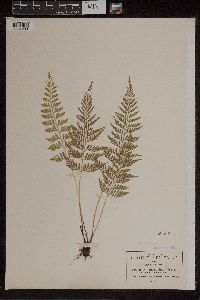 50867[1307233]Pringle, C.G. 89561904-07-21 Mexico, Morelos, mountain canyon above Cuernavaca, 18.933725 -99.228488, 1981m |
MIN:Plants | 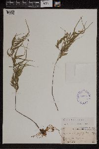 425407[1307234]Smith, Jared G. 751892-02-16 Mexico, Orizaba, 17.679814 -92.484738 |
MIN:Plants | 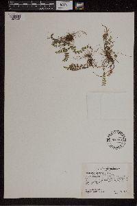 Asplenium castaneum Schltdl. & Cham. 507014[1307236]Ownbey, Gerald B. 19471953-09-28 Mexico, Durango: Road between Durango, Dgo, and Villa Union, Sin.; 60 miles southwest of El Salto, Dgo. (2.8 miles n.e. of El Paraiso, Sin.), 21.171348 -104.779442, 2073m |
MIN:Plants | Asplenium castaneum Schltdl. & Cham. 51001[1307237] Mexico |
MIN:Plants | 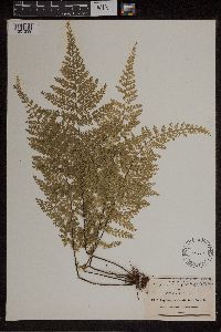 50878[1307239]Pringle, C.G. 40721891-12-04 Mexico, San Luis Potosi, Tamasopo Canyon, 21.943433 -99.510285 |
MIN:Plants | 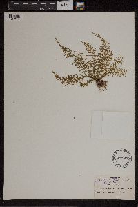 497058[1307240]Pringle, C.G. 60941895-01-21 Mexico, Vera Cruz, barranca near Orizaba, 17.679814 -92.484738, 1219m |
MIN:Plants | 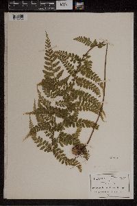 Asplenium eatonii Davenp. 50898[1307253]Pringle, C.G. 103001906-09-08 Mexico, Puebla, 1981m |
MIN:Plants |  50882[1307254]Pringle, C.G. 60721894-12-03 Mexico, Oaxaca, Sierra de San Felipe in Benito Juarez National Park, 31.017029 -114.833695, 2591m |
MIN:Plants |  Asplenium glenniei Baker 50929[1307258]Pringle, C.G. 8331886-11-04 Mexico, Chihuahua, Mapula Mountains, 28.50847 -105.9409 |
MIN:Plants |  Asplenium glenniei Baker 50928[1307259]Pringle, C.G. s.n.1905-10-12 Mexico, Durango, south of Sandias, 25.25 -105.6, 1981m |
MIN:Plants |  Asplenium fibrillosum Pringle & Davenp. 50909[1307261]Pringle, C.G. 87911903-09-06 Mexico, Federal District, Mexico City, near Eslaba, 22.777006 -102.150391 |
MIN:Plants |  50917[1307266]Pringle, C.G. 33641890-11-25 Mexico, San Luis Potosi, Tamasopo Canyon, 21.943433 -99.510285 |
MIN:Plants |  597660[1307267]Heckenlaible, J. 53-91-P1953-06-13 Mexico, Tamaulipas, Sierra Madre Oriental, 4 miles northwest of Gomez Farias, 23.077701 -99.194684, 1067m |
MIN:Plants |  518260[1307274]Barkelew, F.E. 2151903-05-27 Mexico, Colima, Revillagigedo, Revillagigedo Islands, Socorro Island, 18.758452 -110.999291 |
MIN:Plants |  Asplenium monanthemum Murray 50955[1307275]Smith, J.G. 941892-09-00 Mexico, Veracruz, Orizaba, maybe Orizaba mountain?, 17.679814 -92.484738 |
MIN:Plants | 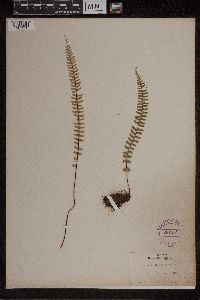 Asplenium monanthemum Murray 281158[1307276]Durand, E.J. 117751903-11-13 Mexico, Federal District, Mexico City |
MIN:Plants | 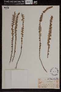 Asplenium monanthemum Murray 50954[1307277]Smith, J.G. 601892-02-27 Mexico, Puebla, Aljojuca, Foot of Mount Orizaba, 17.679814 -92.484738, 3170m |
MIN:Plants | 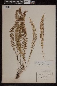 50845[1307278]Pringle, C.G. 87541903-11-15 Mexico, Federal District, Mexico City, 2377m |
MIN:Plants | 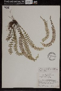 507008[1307279]Ownby, G.B. 19431953-09-28 Mexico, Durango, Road between Durango, Dgo, and Villa Union, Sinaloa ; 60 miles southwest of El Salto, Durango (2.8 miles northeast of El Paraiso, Sinaloa, 21.171348 -104.779442, 2073m |
MIN:Plants |  507010[1307280]Ownbey, G.B. 19441953-09-28 Mexico, Durango, Durango, Road between Durango, Dgo, and Villa Union, Sin.; 60 miles southwest of El Salto, Dgo. (2.8 miles n.e. of El Paraiso, Sin.), 21.171348 -104.779442, 2073m |
MIN:Plants |  507041[1307281]Ownbey, G.B. 19731953-09-29 Mexico, Durango, Road between Durango, Durango and Villa Union, Sinaloa; 51.6 miles southwest of El Salto, Durango (11.2 miles norhteast of El Paraiso, Sinaloa); on overhanging cliffs by steam, 21.171348 -104.779442, 2377m |
MIN:Plants |  507020[1307282]Ownbey, G.B. 19411953-09-28 Mexico, Durango, Road between Durango, Durango and Villa Union, Sinaloa ; 60 miles southwest of El Salto, Durango ; (2.8 miles norhteast of El Paraiso, Sinaloa), 21.171348 -104.779442, 2073m |
MIN:Plants |  507007[1307284]Ownbey, G.B. 19421953-09-28 Mexico, Durango, Road between Durango, Dgo and Villa Union, Sinaloa ;;; 60 miles southwest of El Salto, Dgo. (2.8 miles northeast of El Paraiso, Sinaloa), 21.171348 -104.779442, 2073m |
MIN:Plants | 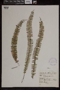 366036[1307285]Hinton, G.B. 111111937-12-24 Mexico, Guerrero, Galeana, 2500m |
MIN:Plants | 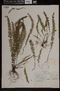 298120[1307286] 16051927-01-31 Mexico, Jalisco, Real Alto, Arroyo de las Cruzes ; Sierra Madre Occidental, 25 -105, 2500m |
MIN:Plants | 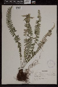 Asplenium L. 304142[1307290]Mexia, Y. 15571927-01-24 Mexico, Jalisco, San Sebastian, Sierra Madre Occidental, 25 -105 |
MIN:Plants | 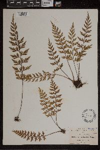 Asplenium L. 50919[1307291]Pringle, C.G. 33631890-11-00 Mexico, Michoacan, hills of Patzcuaro, 19.515938 -101.608867 |
MIN:Plants | 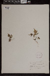 Asplenium L. 297996[1307295]Mexia, Y. 11821926-11-29 Mexico, Jalisco, Quimixto, 70m |
MIN:Plants | 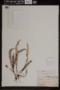 Asplenium L. 51042[1307301]Smith, J.G. 921892-01-14 Mexico, Veracruz, Orizaba |
MIN:Plants | 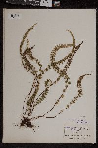 Asplenium L. 51053[1307302]Pringle, C.G. 61501895-10-07 Mexico, Mexico, Sierra de las Cruces, 20.001818 -101.388465, 3658m |
MIN:Plants | 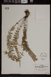 Asplenium sessilifolium Desv. 558824[1307307]Pringle, C.G. 156131908-06-17 Mexico, Hidalgo, Barranca below Honey Station, 20.238845 -98.212529 |
MIN:Plants | 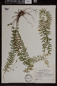 Asplenium sessilifolium Desv. 507013[1307308]Ownby, Gerald B. 19481953-09-28 Mexico, Durango, On road between Durango, Dgo, and Villa Union, Sin.; 60 miles southwest of El Salto, Dgo. (2.8 miles n.e. of El Paraiso, Sin.), 21.171348 -104.779442, 2073m |
MIN:Plants | 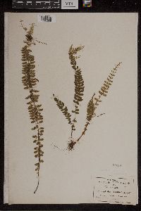 Asplenium sessilifolium Desv. 51108[1307309]Pringle, C.G. 89751904-05-10 Mexico, Hidalgo, Barranca below Trinidad Iron Works, 20.238845 -98.212529, 1524m |
MIN:Plants | 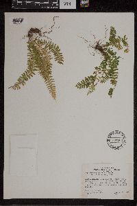 Asplenium sessilifolium Desv. 507006[1307310]Ownby, Gerald B. 19401950-09-28 Mexico, Durango, On road between Durange, Dgo, and Villa Union, Sin; 60 miles southwest of El Salto, Dgo. (2.8 miles n.e. of El Paraiso, Sin.), 21.171348 -104.779442, 2073m |
MIN:Plants | 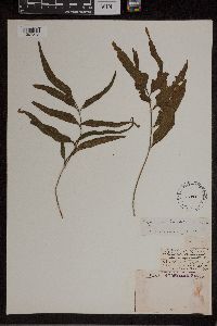 Asplenium tuerckheimii Maxon 52011[1307313]Finck, Hugo 1571890-01-00 Mexico, Cordovenses, 22.045742 -101.930664 |
MIN:Plants | 92446[1310128]Pringle, C.G. Mexico, Jalisco, Detailed locality information protected. This is typically done to protect rare or threatened species localities. |
MIN:Plants |  281512[1309291]Mexia, Ynes 12521926-12-08 Mexico, Jalisco, Santa Cruz de Vallarta, 15.74952 -96.126841, 300m |
MIN:Plants |  304197[1309293]Mexia, Ynes 5331926-09-10 Mexico, Nayarit, Road from Tepic to Los Aguacotes, 21.509505 -104.895691, 1000m |
MIN:Plants |  610710[1309507]Hevly, R.H. 21251961-04-02 Mexico, Baja California, 4 miles South San Vicente, 32.318237 -116.913267, 131m |
MIN:Plants |  297362[1309508]Mexia, Y. 18571927-03-10 Mexico, Jalisco, Trail from Hacienda del Ototal. Sierra Madre, 1500m |
MIN:Plants | Encyclia Hook. 92584[1310255]Pringle, C.G. Mexico, Michoacan, Detailed locality information protected. This is typically done to protect rare or threatened species localities. |
MIN:Plants | Encyclia adenocaula La Llave & Lex. 92621[1310256]Pringle, C.G. Mexico, Jalisco, Detailed locality information protected. This is typically done to protect rare or threatened species localities. |
MIN:Plants | Encyclia cochleata Lemée 507038[1310258]Ownbey, Gerald B. Mexico, San Luis Potosi, Detailed locality information protected. This is typically done to protect rare or threatened species localities. |
MIN:Plants | Encyclia radiata Lindl. 92606[1310262]Pringle, C.G. Mexico, San Luis, Detailed locality information protected. This is typically done to protect rare or threatened species localities. |
MIN:Plants | Encyclia varicosa Bateman 92618[1310267]Pringle, C.G. Mexico, Morelos, Detailed locality information protected. This is typically done to protect rare or threatened species localities. |
MIN:Plants |  Blechnum meridense Klotzsch 558774[1309592]Pringle, C.G. 157031909-10-06 Mexico, Puebla, By Brooks, Honey Station |
MIN:Plants |  281614[1309598]Mexia, Ynes 13361927-01-01 Mexico, Jalisco, 1425m |
MIN:Plants |  304195[1309599]Mexia, Ynes 5351926-09-10 Mexico, Nayarit, Trail from Tepic to Los Aguncates, 1000m |
MIN:Plants |  51423[1309600]Smith, Jared G. 811892-02-04 Mexico, Veracruz, Minatitlan |
MIN:Plants | Epidendrum anceps Jacq. 92617[1310313]Pringle, C.G. Mexico, Jalisco, Detailed locality information protected. This is typically done to protect rare or threatened species localities. |
Google Map
Google Maps is a web mapping service provided by Google that features a map that users can pan (by dragging the mouse) and zoom (by using the mouse wheel). Collection points are displayed as colored markers that when clicked on, displays the full information for that collection. When multiple species are queried (separated by semi-colons), different colored markers denote each individual species.