University of Minnesota
http://www.umn.edu/
612-625-5000
http://www.umn.edu/
612-625-5000
Minnesota Biodiversity Atlas
Bell Museum
Dataset: MIN-Plants
Taxa: Aspleniaceae
Search Criteria: excluding cultivated/captive occurrences
Bell Museum plants | |
 MIN:Plants |  Asplenium scleroprium Hombr. & Jacq. 616869[1307828]Perrin, Mrs. 104 G1934-12-00 Australia, Tasmania; Lowhead; Launceston, -41.804719 146.388645 |
MIN:Plants |  Asplenium paleaceum R.Br. 50986[1307830]Bloomfield s.n. [Asia?] |
MIN:Plants |  Asplenium phyllitidis D.Don 620509[1307831]Moore, John W. 171 B1926-10-05 French Polynesia, 1st valley SW of Uturoa, -16.726482 -151.447529, 160m |
MIN:Plants |  Asplenium pseudofalcatum Hillebr. 268069[1307833]Hapeman, Dr. H. s.n.1908-04-14 United States, Hawaii, island of Oahu, 21.4333 -157.9667 |
MIN:Plants |  Asplenium rhipidoneuron W.J.Rob. 376203[1307835]Topping, D.L. 38441935-12-15 United States, Hawaii, Palehua- Palikea Ridge, Oahu, 21.4333 -157.9667 |
MIN:Plants |  Asplenium rhipidoneuron W.J.Rob. 376211[1307836]Topping, D.L. 35721932-04-24 United States, Hawaii, Waianae Ridge, Oahu, 21.4333 -157.9667 |
MIN:Plants |  Asplenium sarelii Hook. 278796[1307838]Maire, E.E. 60861910-00-00 China |
MIN:Plants |  620237[1307840]Moore, John W. 2551926-10-28 Japan, 3rd valley south of Uturoa, 36.298139 138.098633, 80m |
MIN:Plants |  Asplenium sphenotomum Hillebr. 376132[1307841]Topping, D.L. 119471927-07-29 United States, Hawaii, Pipe-line Trail, Olinda, Maui, 20.770239 -156.268158 |
MIN:Plants |  Asplenium sphenotomum Hillebr. 51109[1307842]Heller, A.A. 27651895-08-30 United States, Hawaii, Kauai, On Kaholuamanoa above waimea, 1219m |
MIN:Plants |  Asplenium sphenotomum Hillebr. 376145[1307843]Degener, Otto 58421928-06-04 United States, Hawaii, Molokai, Kahuaawi Gulch, 21.136241 -157.010941 |
MIN:Plants |  Asplenium tenerum Gaudich. 620281[1307844]Moore, John W. 2481926-10-27 French Polynesia, Raiatea, 3rd valley south of Uturoa, -16.726482 -151.447529, 20m |
MIN:Plants |  Asplenium tenerum Gaudich. 220356[1307845]Weber, C.M. 15591912-01-00 Philippines, Gagayan, Luzin, Abulug river, 18.460288 121.448681 |
MIN:Plants |  Asplenium tenerum Gaudich. 51110[1307846]Powell, Revd L. s.n.1885-05-00 Samoa |
MIN:Plants |  Asplenium tenerum Gaudich. 289914[1307847]Grant, Martin L. 35291930-05-12 French Polynesia, Tahiti, Diadem [mountains], -17.633333 -149.45, 539m |
MIN:Plants |  Asplenium tenerum Gaudich. 289913[1307848]Grant, Martin L. 39161930-07-02 French Polynesia, Teahupoo, Ronui [Mountain], -17.846451 -149.266821, 811m |
MIN:Plants |  Asplenium tenerum Gaudich. 289912[1307849]Grant, Martin L. 53821931-02-18 French Polynesia, Afareaitu, Moorea, Puutoa, -17.679809 -149.397095, 224m |
MIN:Plants |  Asplenium unilaterale Colla 408908[1309027]Whitcomb, William K. s.n.1939-08-00 India, One mile below Jubberkhet spring, Mussoorie (hill station), Dehra Dun District, United Provinces of India. Himalaya Mts., 30.416667 77.933333, 1829m |
MIN:Plants |  Asplenium unilaterale Colla 51048[1309028]Stanford, Arthur W. 2101894-10-00 Japan, Kamo gamo[?], Kyoto, 36.298139 138.098633 |
MIN:Plants |  Asplenium unilaterale Colla 268065[1309029]Hapeman, Dr. H. s.n.1908-05-11 United States, Hawaii, Oahu, on Island of Oahu, 21.4333 -157.9667 |
MIN:Plants |  Asplenium unilaterale Colla 620177[1309031]Moore, John W. 7121927-04-02 French Polynesia, Society Islands; Island of Raiatea; west side of highest mountain, -17 -150, 800m |
MIN:Plants |  Asplenium unilaterale Colla 376048[1309032]Degener, Otto 39951928-04-10 United States, Hawaii, between Waikolu Valley and near northern base of Puu Alii, Molokai, T.Hawaii., 21.1333 -157 |
MIN:Plants |  Asplenium unilaterale Colla 959214[1309030]Heller, A.A. 28441895-10-01 United States, Hawaii, Kauai, Island of Kauai, on Kaholuamanoa, above Waimea, 22.05 -159.5, 762m |
MIN:Plants |  Asplenium unilaterale Colla 368601[1309033]Topping, D.L. 34981932-03-13 United States, Hawaii, Tvie Break Trail, Oahu, T.H., 21.3 -157.866667 |
MIN:Plants |  Asplenium unilaterale Colla 368602[1309034]Topping, D. LeRoy 33581930-05-16 United States, Hawaii, Oahu, Island of Oahu; Slopes of Puu Hapapa, 21.4333 -157.9667 |
MIN:Plants |  Asplenium unilaterale Colla 363981[1309035]Topping, D.L. 34271931-03-16 United States, Hawaii, Oahu, Kahana Ditch Trail, Oahu, T.H., 21.4333 -157.9667 |
MIN:Plants |  Asplenium unilaterale Colla 278373[1309036]Hitchcock, Mrs. s.n. United States, Hawaii, Sandwich Islands, 21.075084 -157.477539 |
MIN:Plants |  Asplenium yokoscense Franch. & Sav. 51412[1309039]Stanford, Arthur W. s.n.1895-08-00 Japan, Hieiz-[?], 36.298139 138.098633 |
MIN:Plants |  Asplenium dimorphum Kunze 50895[1307909]unknown s.n. Australia, Norfolk Island, -29.028332 167.950853 |
MIN:Plants |  Diellia falcata Brack. 357768[1322775]Topping, D.L. 37311934-03-15 United States, Hawaii, Oahu, Kamokunui, Oahu |
MIN:Plants |  Diellia falcata Brack. 368644[1322776]Topping, D.L. 37311934-03-15 United States, Hawaii, Oahu, Kamokunui, Oahu |
MIN:Plants |  Diellia pumila Brack. 358291[1322777]Topping, D.L. 37401934-04-08 United States, Hawaii, Oahu, Pahakea Pass, Oahu, T.H. |
MIN:Plants | 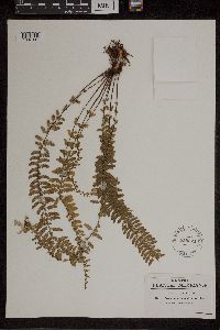 Asplenium sessilifolium Desv. 558824[1307307]Pringle, C.G. 156131908-06-17 Mexico, Hidalgo, Barranca below Honey Station, 20.238845 -98.212529 |
MIN:Plants | 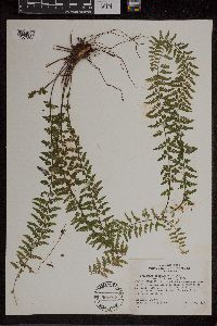 Asplenium sessilifolium Desv. 507013[1307308]Ownby, Gerald B. 19481953-09-28 Mexico, Durango, On road between Durango, Dgo, and Villa Union, Sin.; 60 miles southwest of El Salto, Dgo. (2.8 miles n.e. of El Paraiso, Sin.), 21.171348 -104.779442, 2073m |
MIN:Plants | 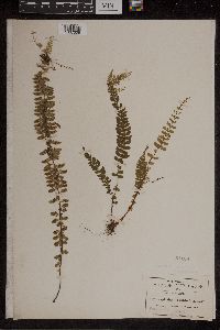 Asplenium sessilifolium Desv. 51108[1307309]Pringle, C.G. 89751904-05-10 Mexico, Hidalgo, Barranca below Trinidad Iron Works, 20.238845 -98.212529, 1524m |
MIN:Plants | 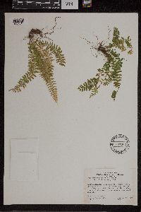 Asplenium sessilifolium Desv. 507006[1307310]Ownby, Gerald B. 19401950-09-28 Mexico, Durango, On road between Durange, Dgo, and Villa Union, Sin; 60 miles southwest of El Salto, Dgo. (2.8 miles n.e. of El Paraiso, Sin.), 21.171348 -104.779442, 2073m |
MIN:Plants |  Asplenium tuerckheimii Maxon 52011[1307313]Finck, Hugo 1571890-01-00 Mexico, Cordovenses, 22.045742 -101.930664 |
MIN:Plants |  Asplenium aethiopicum (Burm.f.) Becherer 940651[1307314]Fay, Alice 34411992-06-27 Ecuador, Tungurahua, Baños Canton, East of Baños, 78.416667 -1.383333, 1770m |
MIN:Plants |  Asplenium cirrhatum Rich. 937399[1307318]Vasquez, R. 170611991-07-06 Peru, Maynas, Loreto, Iquitos, Allpahuayo-IIAP. Bosque primario, inundable solo hay grandes lluvias (Quebrada Shimbaico), muestreo de 1000 m cuadrada en subparcelas de 50 x 2 m, -4.166667 -73.5, 150 - 180m |
MIN:Plants |  Asplenium cirrhatum Rich. 485123[1307319]Vasquez, R. 165211991-05-25 Peru, Maynas, Loreto, Iquitos. Allpahuayo. Estación Experimental del Instituto de Investigaciones de la Amazonia Peruana (IIAP); (Quebrada Brashico), -4.166667 -73.5, 150 - 180m |
MIN:Plants |  Asplenium bilobulatum Gand. 220539[1307326]Bang, A. Miguel 2285 Bolivia |
MIN:Plants |  Asplenium bilobulatum Gand. 50947[1307327]Bang, A. Miguel 2419 Bolivia |
MIN:Plants |  Asplenium pearcei Baker 427609[1307328]Vasquez, R. 173751991-07-11 Peru, Maynas, Loreto, Iquitos, Allpahuayo-IIAP., -4.166667 -73.5, 150 - 180m |
MIN:Plants |  Asplenium pearcei Baker 478608[1307329]Timana, M. 21001991-08-28 Peru, Tambopata, Madre de Dios, Las Piedras. Cusco Amazónico, Inventario Permanente., -12.483333 -69.05, 200m |
MIN:Plants | 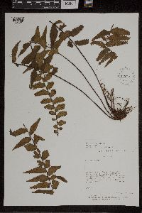 928766[1307331]Killeen, T. 37831992-04-00 Bolivia, Franz Tamayo, La Paz, Serranía de Chepite, Campamento Scismico de Texaco, 15 km O del Río Tuichi., -14.333333 -68.066667, 700m |
MIN:Plants |  Asplenium stubelianum Hieron. 427554[1307336]Vasquez, R. 166361991-05-27 Peru, Maynas, Loreto, Iquitos, Allpahuayo. Estación Experimental del Instituto de Investigaciones de la Amazonia Peruana (IIAP)., -4.166667 -73.5, 150 - 180m |
MIN:Plants |  Asplenium stubelianum Hieron. 427555[1307337]Vasquez, R. 166961991-05-30 Peru, Maynas, Loreto, Iquitos, Allpahuayo. Estacion Experimental del Instituto de Investigaciones de la Amazonia Peruana (IIAP)., -4.166667 -73.5, 150 - 180m |
MIN:Plants |  Asplenium uniseriale Raddi 447820[1307338]Fay, Alice 38121992-08-02 Ecuador, Napo, Quijos Canton; between Baeza and Quijos, 77.941667 -0.458333, 1920m |
MIN:Plants |  Asplenium zamiifolium Willd. 925564[1307339]Smith, D.N. 63561984-03-00 Peru, Oxapampa, Pasco, Trail between Yanahuanca and Chumalli along Rio Pozuzo, -11.77974 -75.05808, 820 - 1100m |
MIN:Plants |  Phyllitis nigripes (Fée ex T.Moore) Kuntze 53048[1378334] Mexico, San Luis Potosi |
MIN:Plants |  Phyllitis plantaginea Kuntze 281214[1378335] Brazil |
Google Map
Google Maps is a web mapping service provided by Google that features a map that users can pan (by dragging the mouse) and zoom (by using the mouse wheel). Collection points are displayed as colored markers that when clicked on, displays the full information for that collection. When multiple species are queried (separated by semi-colons), different colored markers denote each individual species.